

Click the link to read the article on The Aspen Daily News website (Lucy Peterson). Here’s an excerpt:
April 17, 2026
Roaring Fork Valley governments and fire and law enforcement agencies are gearing up for what is anticipated to be a much warmer and drier summer than normal. The Roaring Fork Valley is experiencing a “record breaking year” for drought, snowfall and snowpack, Erin Walter, a meteorologist with the National Weather Service, said during a press briefing Thursday with multiple local emergency management and fire leaders. The agencies are emphasizing both individual preparedness and cross-agency preparedness in hopes of mitigating wildfires or minimizing the damage of wildfires if they occur this summer.
“Wildfires are inevitable,” said Ali Hammond, director of wildfire resilience for Aspen Fire. “Wildfire disasters are preventable.”
Local leaders are encouraging individuals to make their own wildfire preparedness plans, like building a go-bag and establishing an evacuation plan. They’re also urging homeowners to harden their homes and ensure the first 5 feet around their homes is cleared of any vulnerable vegetation…Agencies across the valley are changing evacuation frameworks to “ready, set, go,” which they will use when notifying residents about wildfire risk in their area. They’re also trying to improve their messaging on wildfire risks, like red flag warnings and what different stages of a fire ban mean. Local officials are working to prevent wildfires from a number of angles. But it can be difficult under unprecedented circumstances. The city of Aspen is currently under stage two drought restrictions. Erin Loughlin-Molliconi, the city of Aspen’s utilities director, said the city is considering more stringent measures because of the persistent, dry conditions.

Click the link to read the article on the Circle of Blue website (Brett Walton):
April 19, 2026
Difficult decisions for the Colorado River are starting to be made.
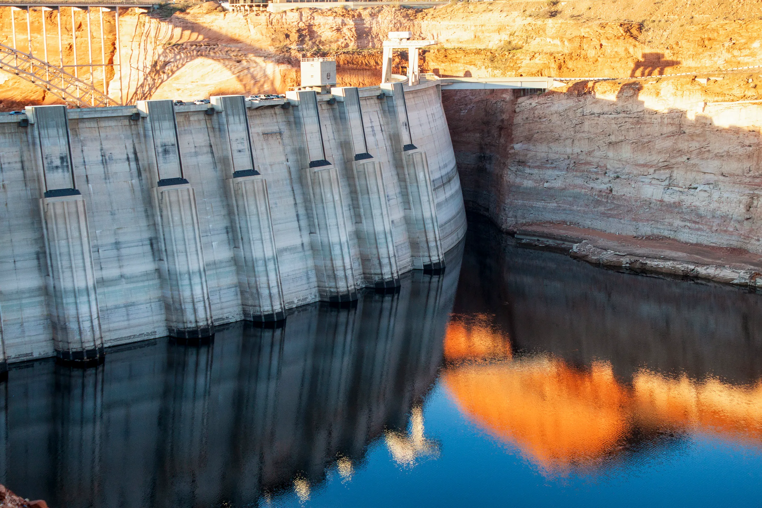
In what will be a defining year for the struggling watershed, the federal agency that manages the basin’s dams took unprecedented actions on Friday to store more water in Lake Powell in order to preserve hydropower generation and protect water-delivery infrastructure at Glen Canyon Dam that the agency says is at risk of damage due to low reservoir levels.
The April 17 announcement from the Bureau of Reclamation will also set in motion events that could result in first-ever lawsuits from Arizona, California, or Nevada against their upstream neighbors over water supply from the shrinking Colorado River.
The Central Arizona Project, which delivers Colorado River water to Phoenix and Tucson, called Reclamation’s actions “a band-aid” and urged the agency to release even more water from upstream reservoirs into Powell. CAP, because it has lowest water-rights priority in the lower basin, is the most vulnerable to proposed water cuts that would attempt to align water supply with demand.
“There is no time to delay,” Patrick Dent, CAP’s assistant general manager for water policy, told Circle of Blue two days before the announcement.
The Bureau of Reclamation will make two moves to support Lake Powell, the huge reservoir formed by Glen Canyon Dam that is less than 25 percent full and shrinking.
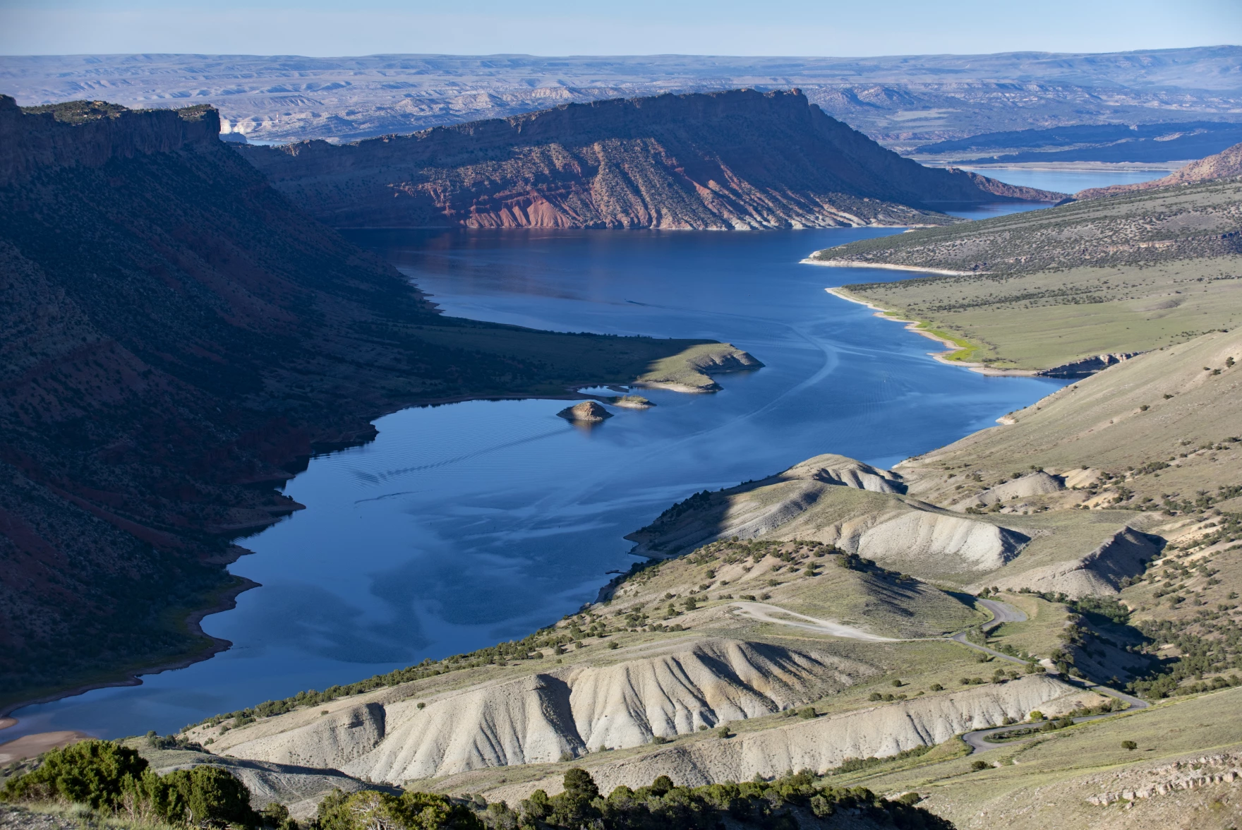
Reclamation’s first move is to release more water from Flaming Gorge, an upstream reservoir that is 82 percent full. With the consent of the four upper basin states, between 660,000 acre-feet and 1 million acre-feet will flow from Flaming Gorge into Powell over the next 12 months.
Reclamation previously used upstream reservoirs to prop up Powell in 2022-23, when some 463,000 acre-feet were released. These extra releases are supposed to be recovered if water supply conditions turn favorable. If more dry years are ahead, then the upstream releases will have been a one-shot intervention.
The agency’s second move is to hold back more water in Powell. Using authority granted in a 2024 decision, the agency will cut Powell’s water releases from 7.48 million acre-feet to 6 million acre-feet. This is the first time that Reclamation has invoked its Section 6(E) authority.
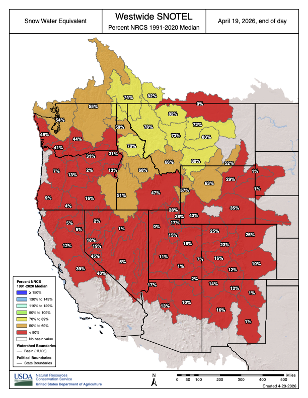
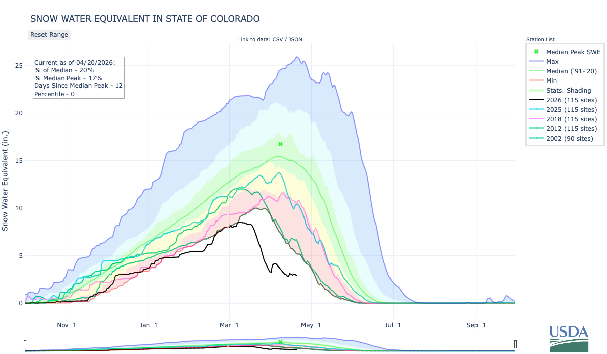
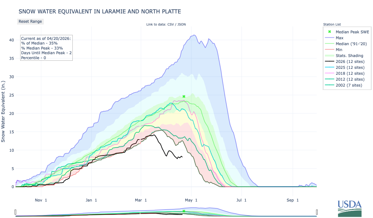
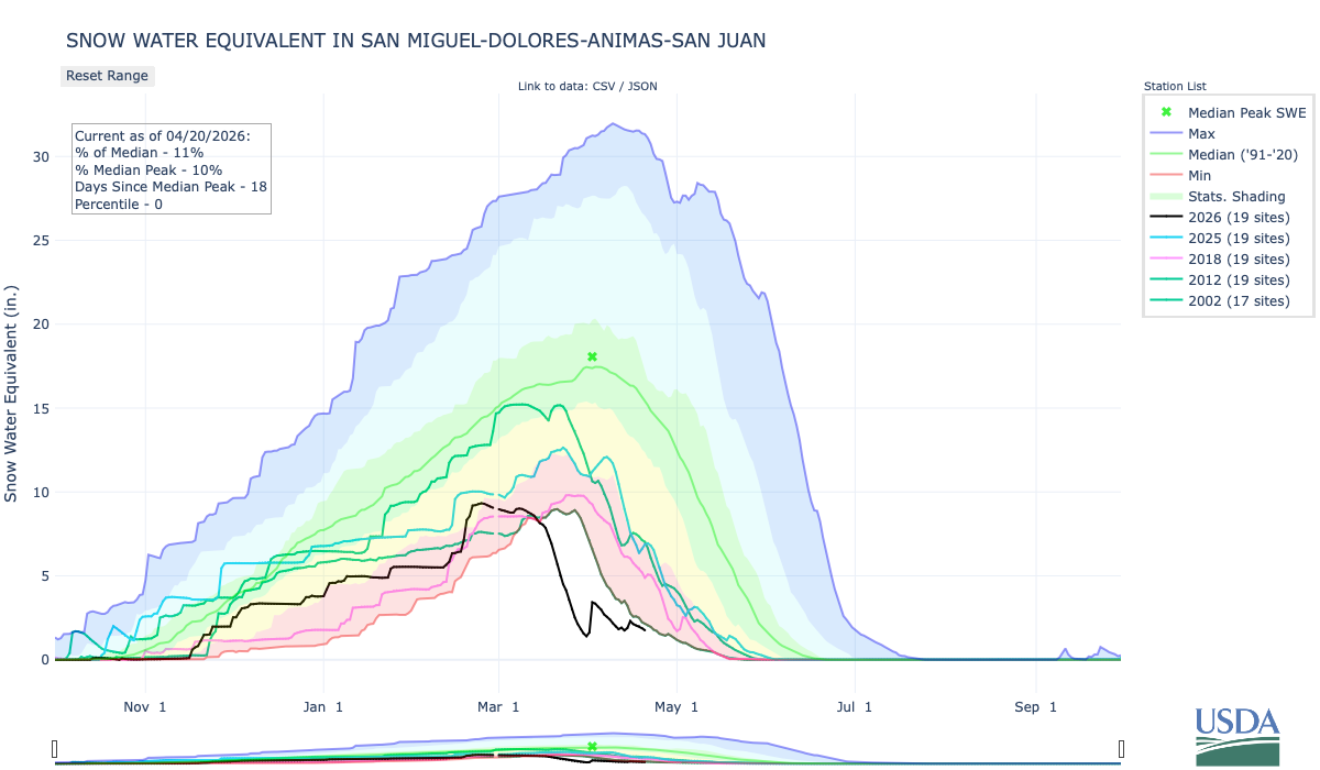
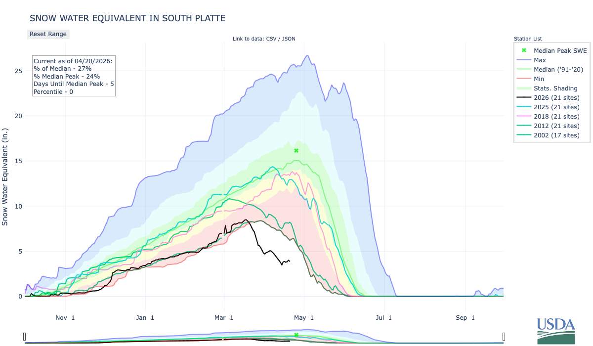
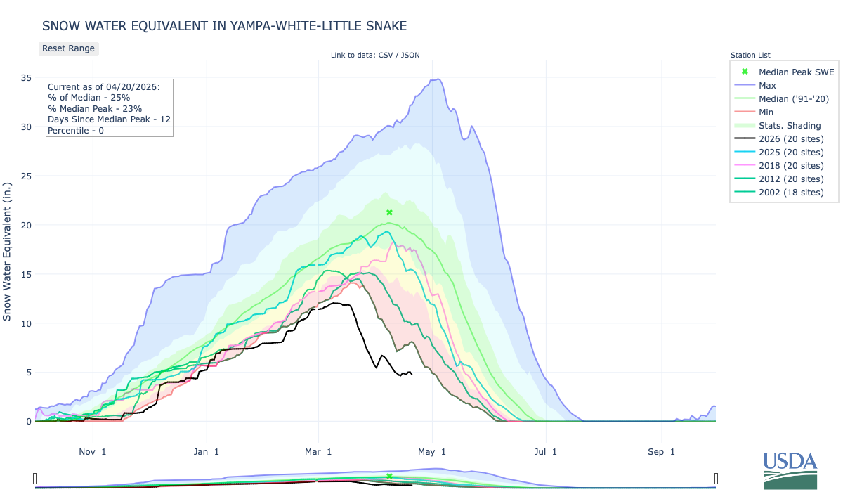
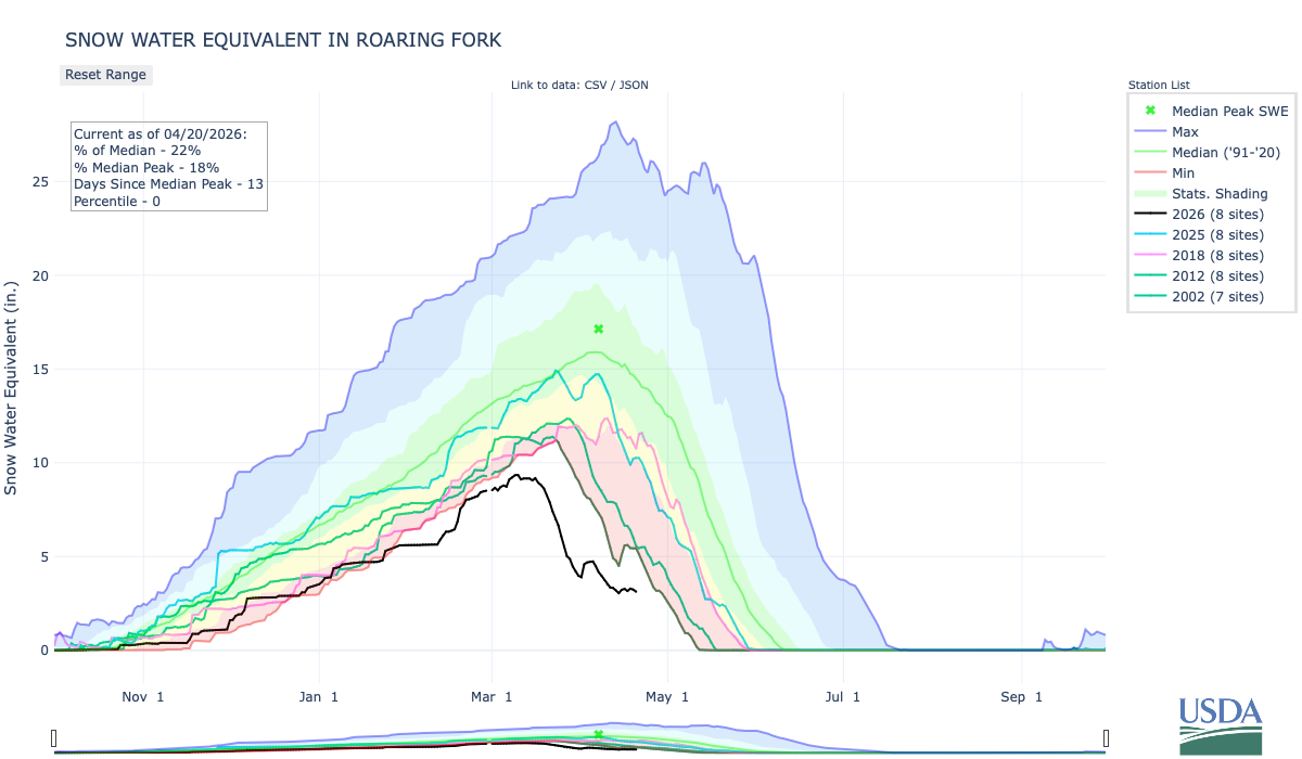
Water supply conditions in the basin worsened each month this year as hot, dry weather drained a meager snowpack that is on a downward trend due to manmade climate change. A heat wave in late March was the most extreme on record in the Southwest for that time of year. Inflows into Lake Powell this year are projected to be the lowest ever measured, breaking a record set in 2002.
The water elevation at Powell currently sits at 3,526 feet. Reclamation has stated that it will do what it can to prevent the reservoir from dropping below 3,500 feet. Hydropower generation stops at 3,490 feet. Without Reclamation’s announced interventions, that level is expected to be breached by August.
With the two interventions, Powell is projected, with average weather conditions, to remain above 3,500 feet by April 2027, but just barely. If the next 12 months continue to be hot and dry, more emergency actions might be necessary.

If Powell were to drop below 3,490 feet, water would have to be released through a smaller set of pipes called the river outlet works. Reclamation has said that using these pipes for extended periods of time is untested and risks damaging them.
Reducing outflows from Powell will have two effects. One is that Lake Mead, located downstream, will shrink more quickly, as will its hydropower output. Boating access will be more difficult.
The other consequence is the specter of litigation. The 1922 Colorado River Compact requires the four upper basin states – Colorado, New Mexico, Utah, and Wyoming – to deliver 75 million acre-feet over 10 years. Add in the upper basin’s share of the water required for Mexico and the figure rises to roughly 82.5 million.
Cutting Powell outflows this year to 6 million acre-feet will likely push the 10-year total below the required threshold.
Reclamation is not focusing on the legal implications, says James Eklund, a partner at Taft Law.
“Reclamation is essentially telling the basin states, ‘We are going to protect our billions of dollars’ worth of infrastructure, including Glen Canyon Dam, and if you believe that violates your compact entitlement, you know where the courthouse is’,” Eklund, a former Colorado River commissioner for Colorado, wrote to Circle of Blue.
States in both upper and lower basins have already set aside money for potential litigation or are considering it.
Still, a legal right does not necessarily mean the water is available, Eklund cautions. “No court can conjure acre-feet that aren’t in the reservoir.”


Click the link to read the article on The Denver Post website (Elise Schmelzer). Here’s an excerpt:
April 19. 2026
The multitude of water managers tasked with overseeing the drying Colorado River systemstand at a dire crossroads. As a years long stalemate in negotiations persists between the seven states that share the river, it’s become increasingly likely that the federal government will impose its own long-term plan, choosing from a range of proposals officials have outlined in recent months. But experts and water managers across the 250,000-square-mile Colorado River basin are raising the alarm about the five plans, questioning if any of them hold up under the new climate reality. They say the federal plans won’t keep the system from crashing in critically dry years — which are becoming more frequent — and could wreak chaos on the pivotal lifeline for 40 million people in the American Southwest.
“In every one of those alternatives, under what they call critically dry hydrology, the system is failing,” said Andy Mueller, the general manager of the Colorado River District, a taxpayer-funded agency based in Glenwood Springs that works to protect Western Slope water. “And critically dry hydrology is what we have continued to see consistently in the basin in the last 25 years and what we should expect going forward.”
[…]
In extremely dry years, the longer-term plans under consideration by Reclamation would allow the water levels of the system’s two main reservoirs to repeatedly fall below minimum power pool. Federal officials then would be forced to make recurring emergency cuts to the water supplies of the three states downstream of the reservoirs, creating uncertainty for millions of people and a massive agricultural industry…Letters from a number of Colorado entities — including the Northwest Colorado Council of Governments, irrigation districts, the Western Slope’s Club 20 and county commissions from a vast swath of the state — urged federal officials to present at least one plan that would hold up in extremely dry years.
“Sound science dictates that Colorado River management must evolve to handle a permanently drier future,” Tina Bergonzini, the general manager of the Grand Valley Water Users Association, wrote in her comments to the bureau. “The current federal preference for predictability is an atmospheric impossibility given that studies indicate rising temperatures have already slashed river flows by a fifth.”
[…]
The conflict on the Colorado is likely one of the world’s first major water policy overhauls to grapple with the reality of climate change, said Brad Udall, a senior water and climate research scholar at Colorado State University’s Colorado Water Center. In the past, Colorado River managers made operational tweaks and short-term deals to address drought. This time, it’s different.
“We’re not looking at an incremental step here,” Udall said. “We’re looking at a complete redo of how we operate this resource that affects 40 million people.”

Click the link to read the article on The Land Desk website (Jonathan P. Thompson):
April 17, 2026
🥵 Aridification Watch 🐫
Sometimes it feels like there are two parallel Southwestern United States out there.
One is naturally arid, is getting hotter and hotter by the year and is gripped by the most severe drought of the last millennium or more. Its water lifeline, the Colorado River system, is on the brink of collapse, and communities and farmers from Wyoming to Calexico are facing painful mandatory water cutbacks this summer.
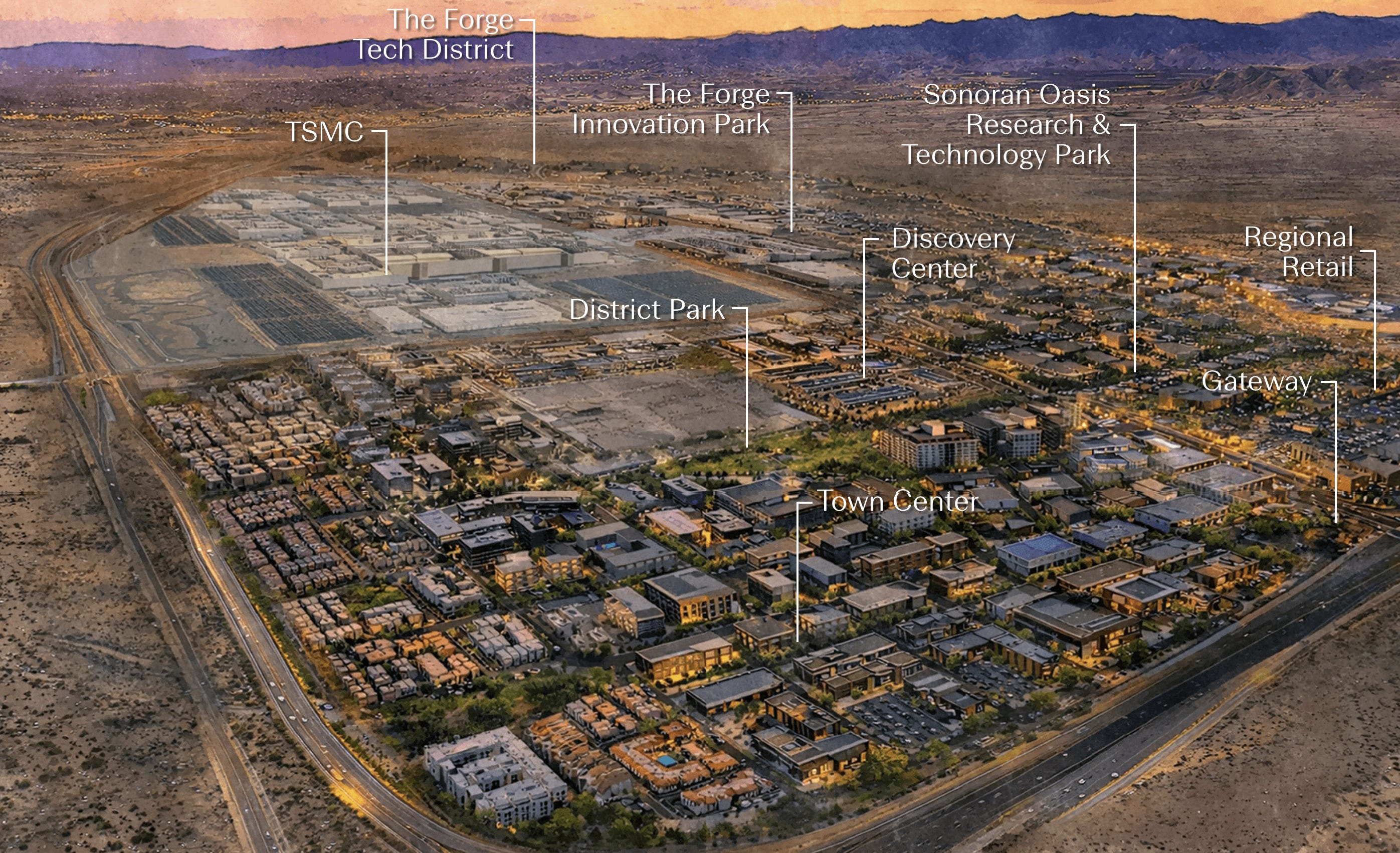
And then there’s the other one, a sort of fantasy world, or maybe just an oblivious one, in which new water diversion projects like the Lake Powell Pipeline remain on the table, state leaders prepare to go to legal war to protect their states’ profligate water consumption, and a developer is breaking ground on a 2,300-acre “city within a city” called Halo Vista in North Phoenix.
Halo Vista’s developers are billing it as a companion development to TSMC’s $165 billion semiconductor fabrication facility complex. It will wrap around the industrial campus (thus the “halo” in the name), and plans call for some 30 million square feet of industrial, retail, office, research, and healthcare spaces along with 9,000 or more residential units.
“You have to think about all the people at full build-out who’ll work in this area — about 60 to 80,000 people,” Greater Phoenix Economic Council President Christine Mackay told AZFamily. “They’ll work in the Halo Vista science and technology park. They need restaurants, hotels, places to live — and places to shop for what they need.”
Historically, Arizona’s economy was said to run on five Cs: copper, cotton, citrus, cattle, and climate. Copper is still going fairly strong, most of the citrus groves have given way to housing developments, alfalfa has surpassed cotton, and the beef-cattle have been replaced by dairy factories. Now another C — computer chips — is being added to the mix, as the Phoenix-area experiences a semiconductor manufacturing boom and a coinciding data-center buildup.
The tech industry’s expansion is adding economic diversity, making the city somewhat less vulnerable to 2008-like financial breakdowns. But as Halo Vista demonstrates, it is also feeding Phoenix’s dominant economic force, the Growth Machine. And both the Growth Machine and the data center/semiconductor boom need water, and quite a lot of it. This, in turn, increases Phoenix’s exposure to future water shortages, which seem more and more likely with each passing day.
According to TSMC’s draft environmental assessment, the first phase of its Phoenix fabrication plants will initially use about 4.75 million gallons of water per day, or 5,320 acre-feet per year, which would jump to about 19,400 acre-feet yearly if and when all three phases are built out. But the company says it will eventually install a recycling system that will bring that number down considerably. The 9,000 residential units in Halo Vista would use about 2,800 acre-feet per year (based on Phoenix’s current per-capita water consumption multiplied by a rough estimate of 20,000 people occupying those residences). Halo Vista’s other industrial and commercial properties will consume an unknown additional amount of water.
So let’s say the whole development, including the “fabs,” will use about 25,000 acre-feet per year — less if the water efficiencies are realized, more if Halo Vista’s tech district includes data centers or other water-intensive industries.
That’s a lot of water, or a drop in the bucket, depending on how you look at it.
On the one hand it is equal to about one-fourth of Nevada’s total consumptive use from the Colorado River. Yes, the city of sin and excess only uses about four times more water than the TSMC/Halo Vista “city” will use.
On the other, it’s far less than the alfalfa farms in Maricopa County — in which Halo Vista is located — use for irrigation each year, which totals something like 500,000 acre-feet.1 And yet, Halo Vista/TSMC, once all built out in 20 years or so, will have a significantly larger economic output than a bunch of hay fields (which isn’t the only measure of value or even the most important one, and yet, well, water does flow uphill to money).
So yes, it is possible to sidestep water concerns by pulling out the “what about alfalfa” comparison. But it’s also not all that productive.
Halo Vista, which is being built on a plot of uncultivated state land in the desert, is not displacing an alfalfa farm’s water use. Rather, it represents a new water use piled on top of existing consumption. The water will come out of Phoenix’s municipal system, and therefore officially has an “assured and adequate” 100-year water supply, which is necessary in Arizona for this sort of development.
Yet there’s nothing assured about Arizona’s water future. Phoenix’s water comes primarily from high priority rights on the Salt and Verde Rivers, and from the Colorado River via the Central Arizona Project. But those rights will hardly matter if the rivers dry up: This year’s Salt River Basin meagre snowpack had vanished by March 1, spring runoff peaked weeks ago, and flows are rapidly falling. Meanwhile, the Central Arizona Project has relatively low priority rights, meaning it will be the first to take cuts as the river shrinks.
In other words, aridification and the Colorado River crisis pose an existential threat to Phoenix’s tech boom and, well, Phoenix, itself, which is one of the reasons Arizona Gov. Katie Hobbs is preparing for a bitter legal fight with the feds and the Upper Basin states over the Colorado River.
The good news for the developers and the semiconductor makers is that agriculture continues to use a lot of water in Arizona. And where there is large consumptive use, there is also more room for increased efficiencies and, if it comes to it, “buying and drying” the farms for their water — which has its own negative consequences. The bad news is that the shortages to come may very well exceed the amount that could be wrung out of the existing farms.
Halo Vista, which is on a 20-year buildout schedule, is far from the only major water- and energy-guzzling development on slate for the increasingly arid West. And maybe it’s not realistic to expect all such development to come to a screeching halt simply because the water may run out sometime in the future. After all, climate change could cause more precipitation; maybe in 20 years we’ll be worrying more about flooding than desiccation.
But you would think that planners and policymakers and the developers would at least act in line with our current reality, where resources, especially water, are limited. Halo Vista-esque projects should be required not just to certify an “assured” 100-year supply, but they also should have to offset new consumption with cuts somewhere else, whether it’s paying for farmers to install drip irrigation or funding treated wastewater recycling projects.
Continuing to consume water at current rates is one thing. Adding new uses on top of our current overconsumption is quite another.
***
And so it begins. It looks like residents of the small Arizona community of Kearney may lose their water altogether later this summer, making developments like Halo Vista look even more surreal.
The town sent this emergency memo out to residents in April:
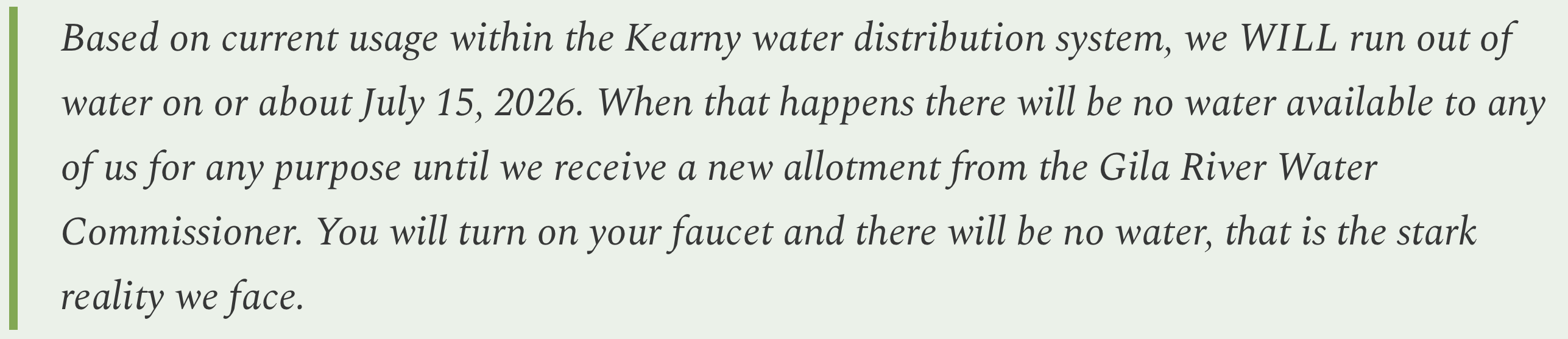
Kearney sits in Arizona’s “Copper Triangle” along the banks of Gila River and in the proverbial shadow of the Hayden copper smelter smokestack. The town was established by the Kennecott Mining Company in 1958 to house residents displaced from Ray, Sonora, and Barcelona as the mine’s gaping Ray mine pit gobbled up the communities. Resolution Copper’s proposed Oak Flat mine is also nearby, as is Faraday’s proposed Copper Creek project.
Kearney has a maximum allotment of 610 acre-feet of water from the Gila River. This year, however, extreme drought conditions have brought the allotment down to just .76 acre-feet, forcing the town to impose severe restrictions on use to try to make it last until the monsoon arrives.
As for all the mines surrounding Kearney? I’m guessing their dealing with their own water issues, but I’d also wager that they’re allowed a heck of a lot more than three-fourths of an acre-foot.
The water footprint of Arizona’s copper mines — Jonathan P. Thompson

🐟 Colorado River Chronicles 💧
In the comment section on the last Land Desk dispatch, reader wkarls reported on the Colorado River’s flows during a recent raft trip on the Grand Canyon. It got me to thinking about how low those flows might go and what that could mean.

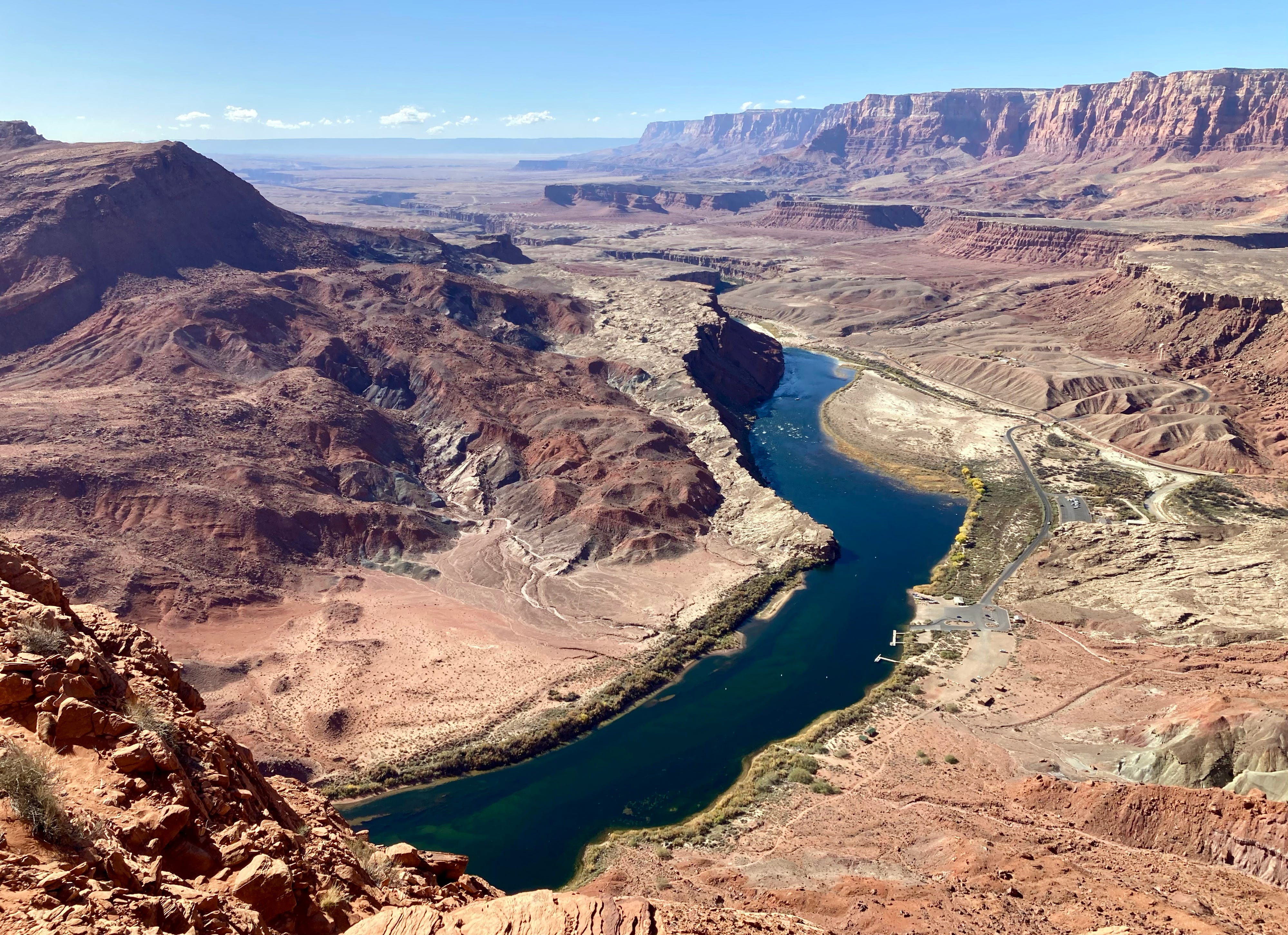
I’ve only boated down the Grand Canyon once, back in October and November of 1995 with a group of slightly crazy Salida rafting folks. It was a beautiful, terrifying, sublime — if somewhat debauched — experience. During the trip, releases from Glen Canyon Dam — which make up about 95% of the flow in the Grand Canyon — fluctuated between 11,000 and 16,000 cubic feet per second, a number that was bolstered downstream after a good rainstorm moved through, turning the river that intimidating blood-and-chocolate-milk color. That seemed like plenty of water to me; it was certainly enough to generate waves big enough to toss our little rafts about like toys (did I mention it was scary as hell?).
Somewhat surprisingly, the releases were about the same in September of last year, bouncing between 10,000 and 16,000 cfs, which appears to have been an effort to get the annual flows past Lees Ferry up to about 7.5 million acre-feet to keep the Upper Basin in compliance with the Colorado River Compact’s non-depletion obligation. Then, on Oct. 1, the beginning of the 2026 water year, releases plummeted. This spring they’ve been in that 7,000 to 9,000 cfs range that wkarls mentioned.
That’s in line with the Bureau of Reclamation’s plan to release just 6 million acre-feet from the dam this water year: 6 million acre-feet per year averages out to about 8,200 cfs. That’s also right in line with the Grand Canyon Protection Act’s operating criteria, which set a minimum allowable release during the day (between 7 a.m. and 7 p.m.) at 8,000 cfs, while the minimum nighttime release is 5,000 cfs.
So, given all of that, we can assume that the flows shouldn’t drop much below current levels this summer. Of course, if conditions are worse than expected, then the reservoir could drop to 3,500 feet earlier than anticipated, which could force dam operators to further curtail releases to “defend” minimum power pool. If so, then you might see nighttime releases drop as low as 5,000 cfs. If that’s not enough, then I suppose dam operators would have to go to a run-of-the-river scenario, where flows could plummet to 2,000 or 3,000 cfs, which would make rafting quite interesting.
📸 Parting Shot 🎞️