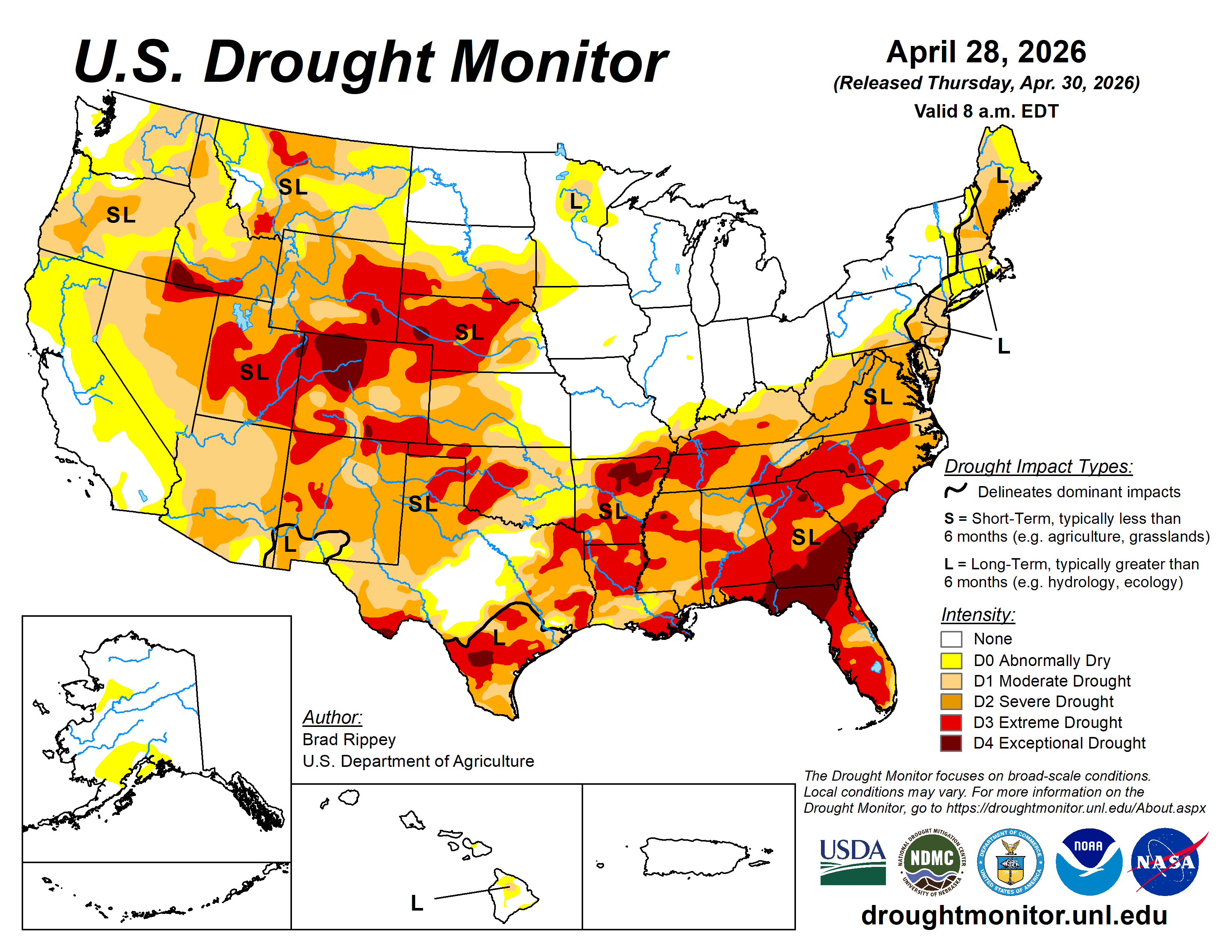
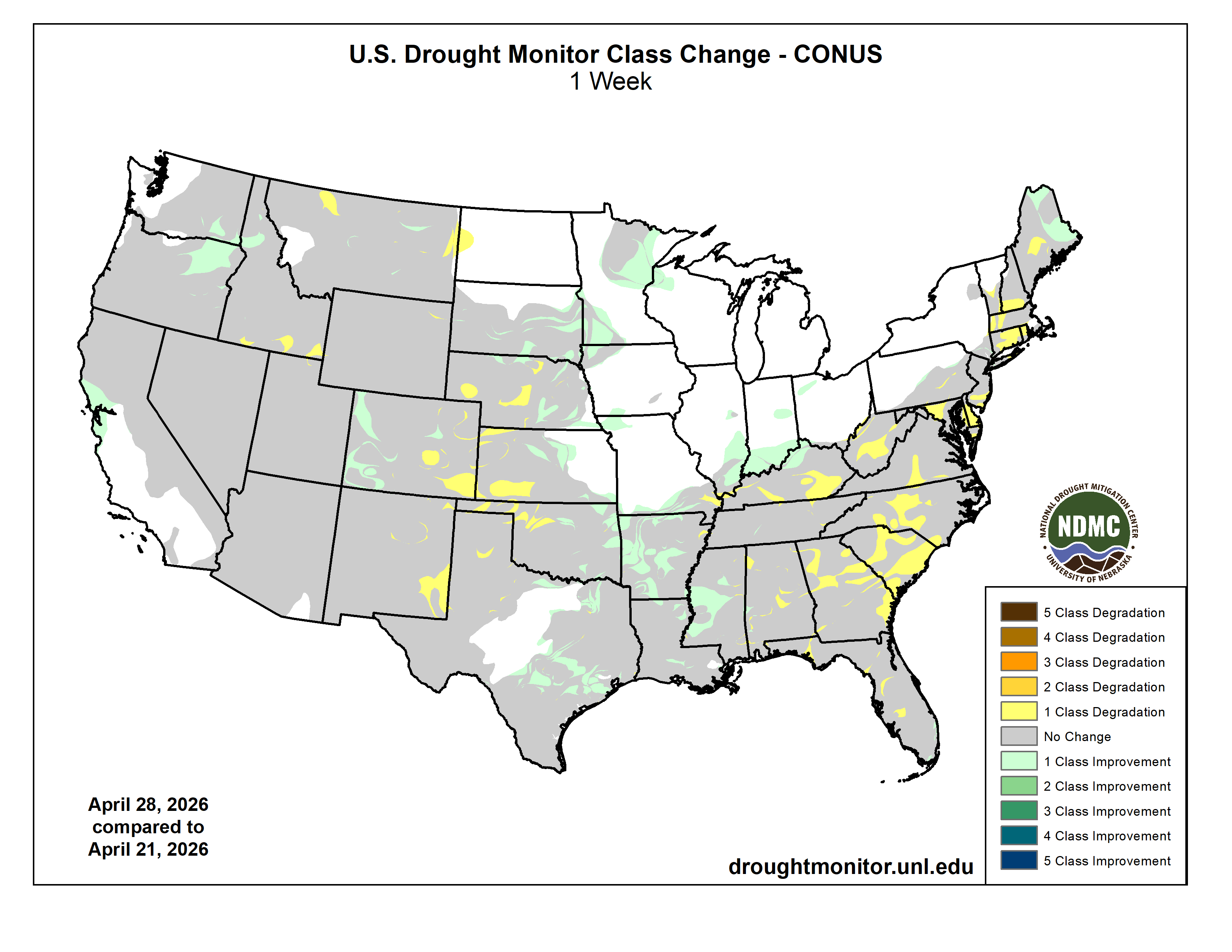
Rain continued to bypass the central and southern High Plains, leaving rangeland, pastures, and winter wheat in desperate need of moisture. Farther east, however, showers and thunderstorms continued to ease drought across the eastern Plains, extending into the mid-South and Mississippi Delta. Some of the heaviest rain, accompanied by locally severe thunderstorms, fell from eastern Kansas into the lower Midwest. The remainder of the Midwest also received some precipitation, although some of the region’s wettest areas in the Great Lakes States got a break from the excessive rain that had led to pockets of record flooding earlier in the month. In contrast, much of New England and northern sections of New York were cool and dry. Elsewhere, unsettled, showery weather prevailed in the West, mainly north of a line from central California to the central Rockies, boosting topsoil moisture, delivering high-elevation snow, and reducing irrigation demands. However, any precipitation did not fundamentally change a mostly bleak Western water-supply outlook for the remainder of the spring into the summer of 2026…
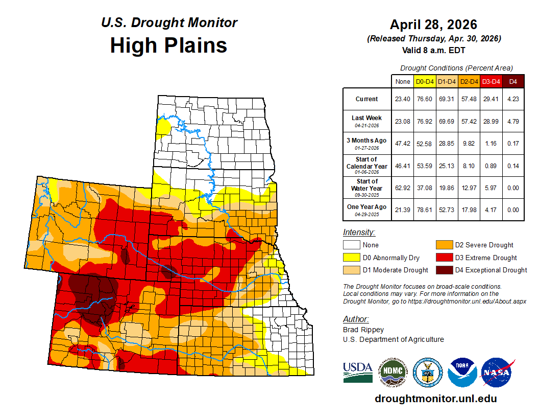
Precipitation delivered drought relief to some areas, including parts of southern South Dakota and eastern sections of Nebraska and Kansas. Still, by April 26, topsoil moisture—as reported by the U.S. Department of Agriculture—was rated at least 40% very short to short in all the region’s states, except North Dakota, and led by Colorado (95%). Winter wheat continued to struggle due to drought and recent freezes, with 65% of Nebraska’s crop rated in very poor to poor condition on April 26, along with 54% in Colorado and 41% in Kansas. Drought continued to generally worsen in eastern Colorado and western sections of Kansas and Nebraska…
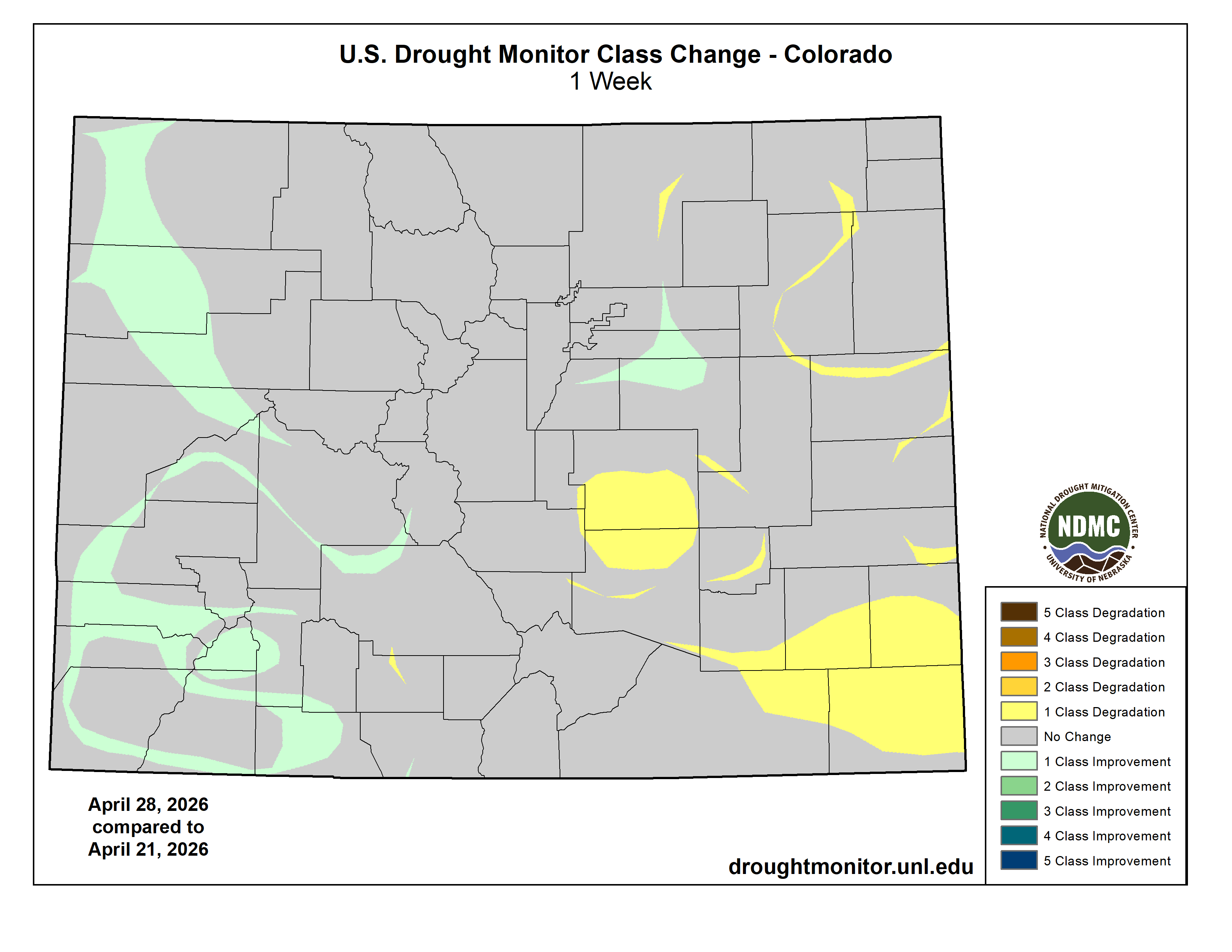
Colorado Drought Monitor one week change map ending April 28, 2026.
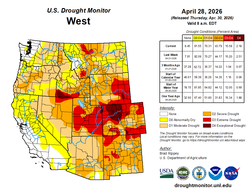
Any changes in the West were mostly minor and mixed, as cooler weather prevailed and spotty precipitation occurred. In most areas, Western precipitation did not alter bleak water-supply prospects, since most of the mountain snowpack has already melted, except in the northern Rockies. Already in late April, fears of an hydroelectricity generation crisis in the Colorado River Basin have led the Department of Interior to start sending water from Flaming Gorge Reservoir downstream to Lake Powell to help boost water levels. The Department of Interior also indicated that water normally destined for Lake Mead, farther downstream, would be held in Lake Powell. Despite overall lack of impact on Western supplies, any precipitation was largely welcomed, due to positive impacts such as a boost in topsoil moisture and a reduction in irrigation demands. In fact, enough precipitation has recently fallen to warrant a slight reduction in drought intensity in a few areas, including parts of western Colorado, northeastern Oregon, and southeastern Washington…
Late in the drought-monitoring period, significant rain overspread portions of the South, resulting in broad reductions in drought intensity. Some of the heaviest rain fell from eastern sections of Oklahoma and Texas into portions of Arkansas, Mississippi, and northern Louisiana. Still, more rain will be needed to ensure full drought recovery, since many of the hardest-hit areas had slipped into extreme to exceptional drought (D3 to D4) in recent weeks. Meanwhile, western sections of the South—including western Oklahoma and western Texas—remained critically dry, leading to poor rangeland, pasture, and winter wheat conditions, as well as a chronically elevated wildfire threat. Statewide, winter wheat in Texas was rated 56% very poor to poor on April 26, along with 45% in Oklahoma…
Looking Ahead
During the next several days, active weather across the South should lead to 1- to 4-inch rainfall totals from much of Texas to the southern Atlantic States. However, some Southern thunderstorms may produce large hail, damaging winds, and isolated tornadoes. The moisture will have a sharp northern edge, with little or no precipitation expected during the next 5 days across the northern and central Plains and Midwest. Generally dry weather will also cover the West, aside from late-season snow in the central and southern Rockies. Elsewhere, a cool pattern across the nation’s mid-section will strengthen, with frost and freezes possible into the weekend across the northwestern half of the Plains into the upper Midwest. By Saturday morning, scattered frost could extend as far south as the Ohio Valley and the southern High Plains.
The NWS 6- to 10-day outlook for May 5 – 9 calls for the likelihood of cooler-than-normal conditions in most areas east of the Rockies, while warmer-than-normal weather will be confined to an area stretching from the Pacific Coast to the northern Rockies, including the Great Basin and northern Intermountain West. Meanwhile, near- or below-normal precipitation from the Pacific Northwest into the upper Midwest should contrast with the likelihood of wetter-than-normal conditions across the remainder of the Lower 48 States.
Drought Monitor one week change map ending April 28, 2026.
This story was produced by Circle of Blue, in partnership with The Water Desk at the University of Colorado Boulder’s Center for Environmental Journalism.
KEY POINTS
Glen Canyon Dam, completed in 1963, was not designed to be operated at extremely low water levels in Lake Powell.
The decline of Lake Powell is putting hydropower generation and downstream water deliveries at risk.
The Bureau of Reclamation, the federal water manager, is studying options for retrofitting Glen Canyon Dam.
In the span of U.S. history certain years are turning points, milestones in the nation’s story. 1776. 1865. 1929. 1968. Circumstance and consequence conspire to make it so.
For the Colorado River and those who rely on it, 2026 is on the verge of similar prominence. Circumstances in the basin today are that urgent.
Udall/Overpeck 4-panel Figure Colorado River temperature/precipitation/natural flows with trend. Lake Mead and Lake Powell storage. Updated through Water Year 2025. Note the tiny points on the annual data so that you can flyspeck the individual years. Credit: Brad Udall
A slow-developing water supply calamity, decades in the making, has boiled over, like a cold war turning hot. Extreme heat in March – triple-digit temperatures never witnessed that early in the year – obliterated a meager snowpack. The basin’s big reservoirs, the supposed buffers against short-term drought, were already uncomfortably low after a quarter-century of declining river flows. They will drop even lower. The amount of water flowing this summer into Lake Powell, the nation’s second-largest reservoir, will be one of the smallest ever measured, barely a trickle.
“This is unprecedented, but it’s not unpredicted,” said Eric Balken, executive director of the Glen Canyon Institute. “I like to say that this is the most predicted disaster of all time.”
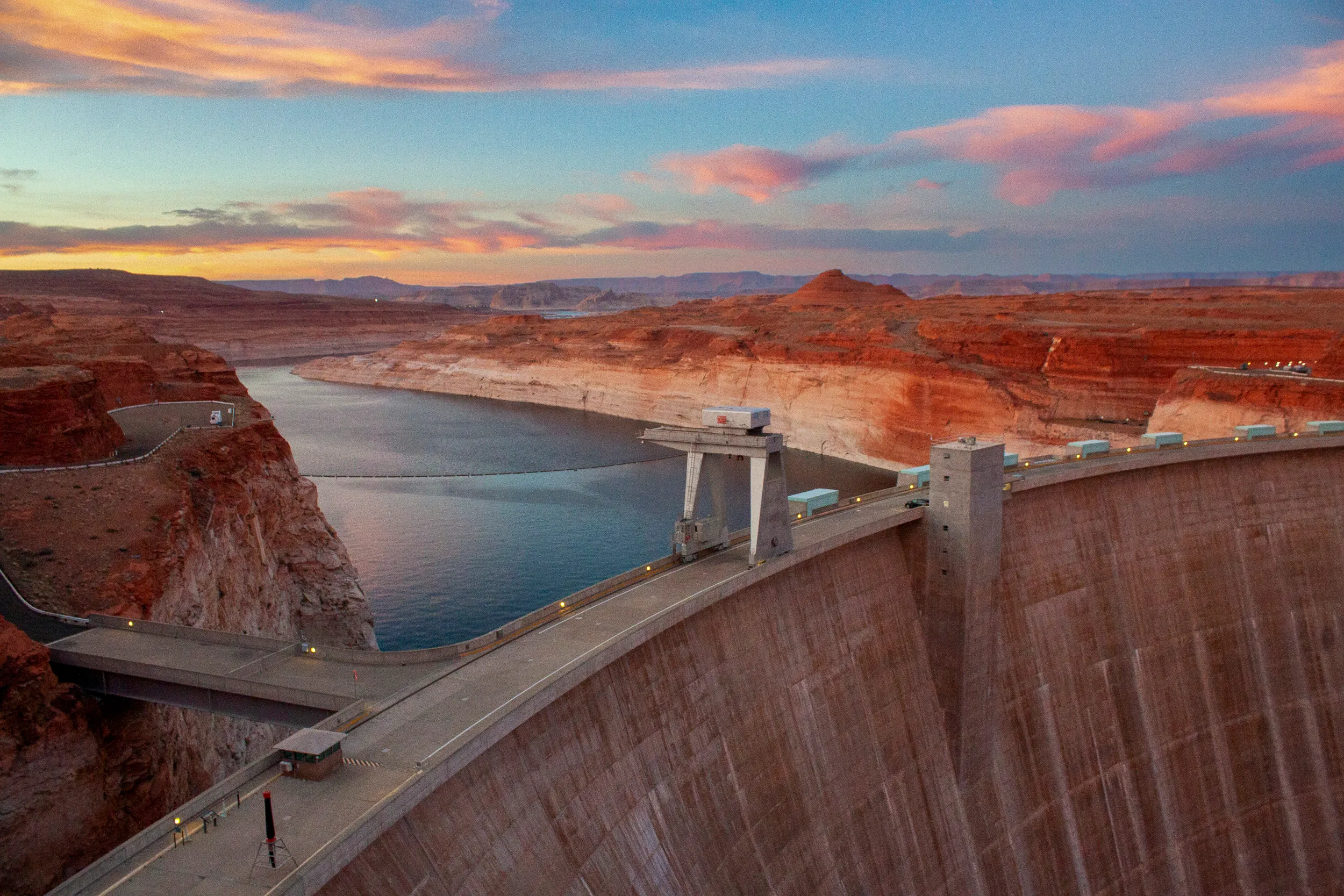
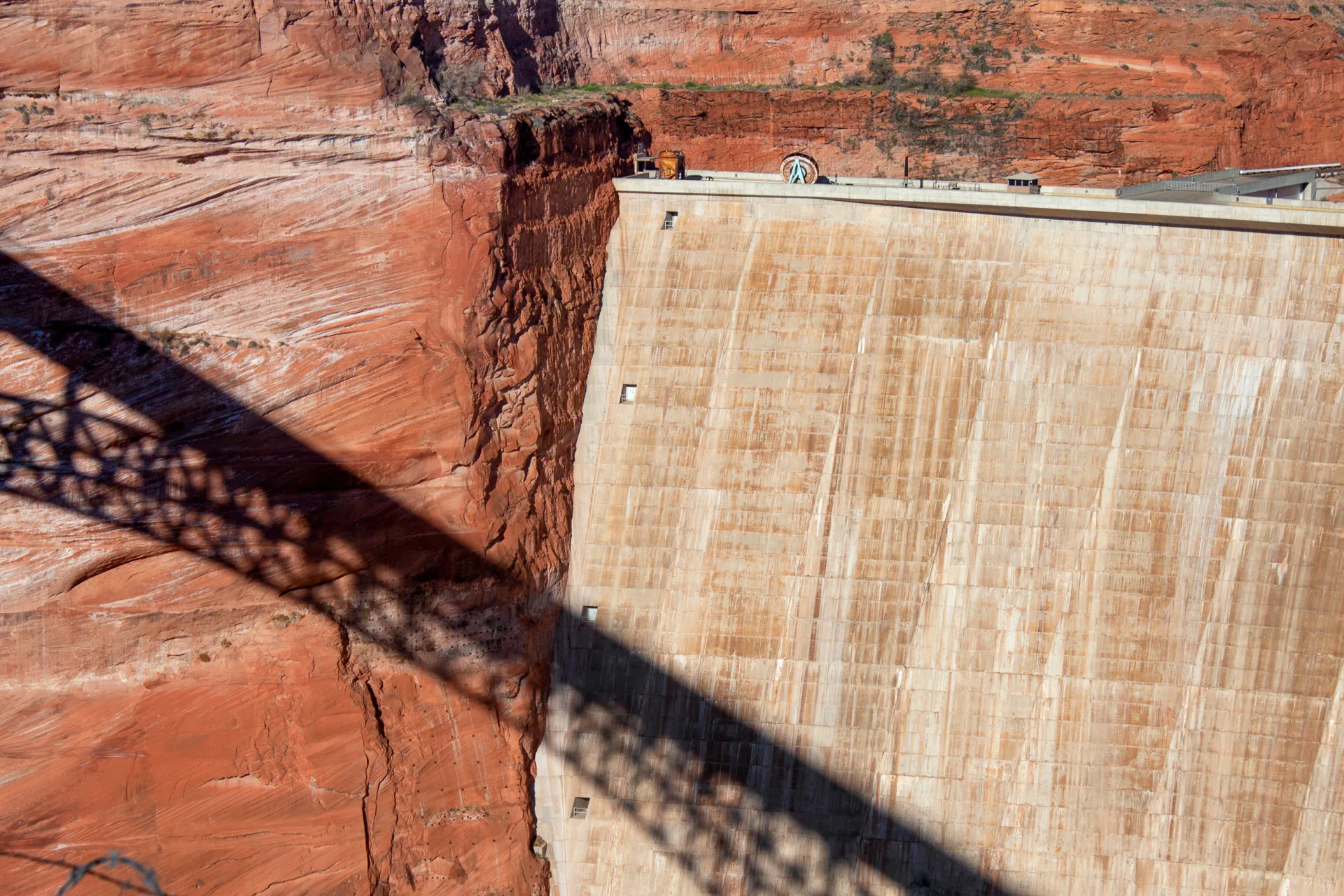
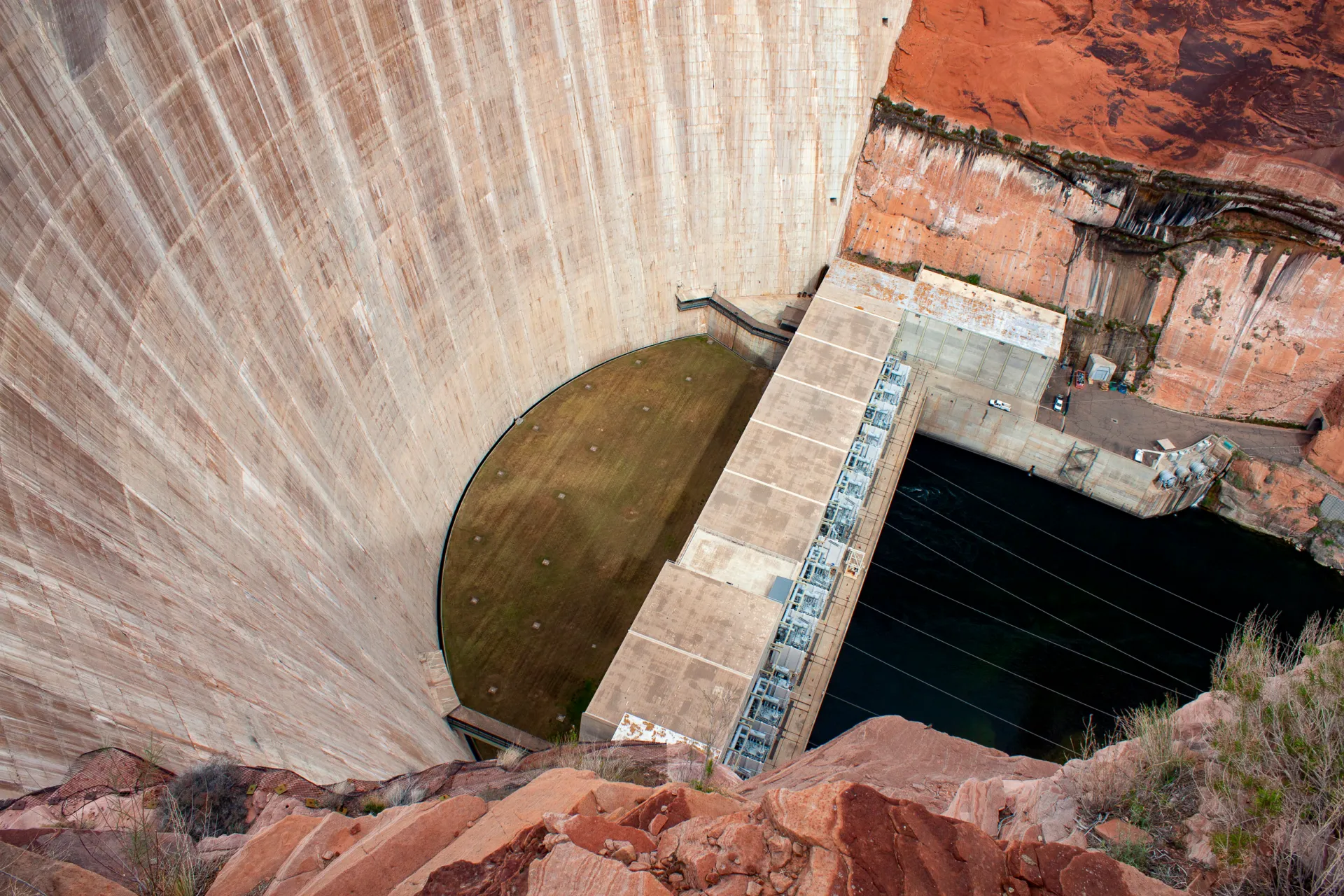
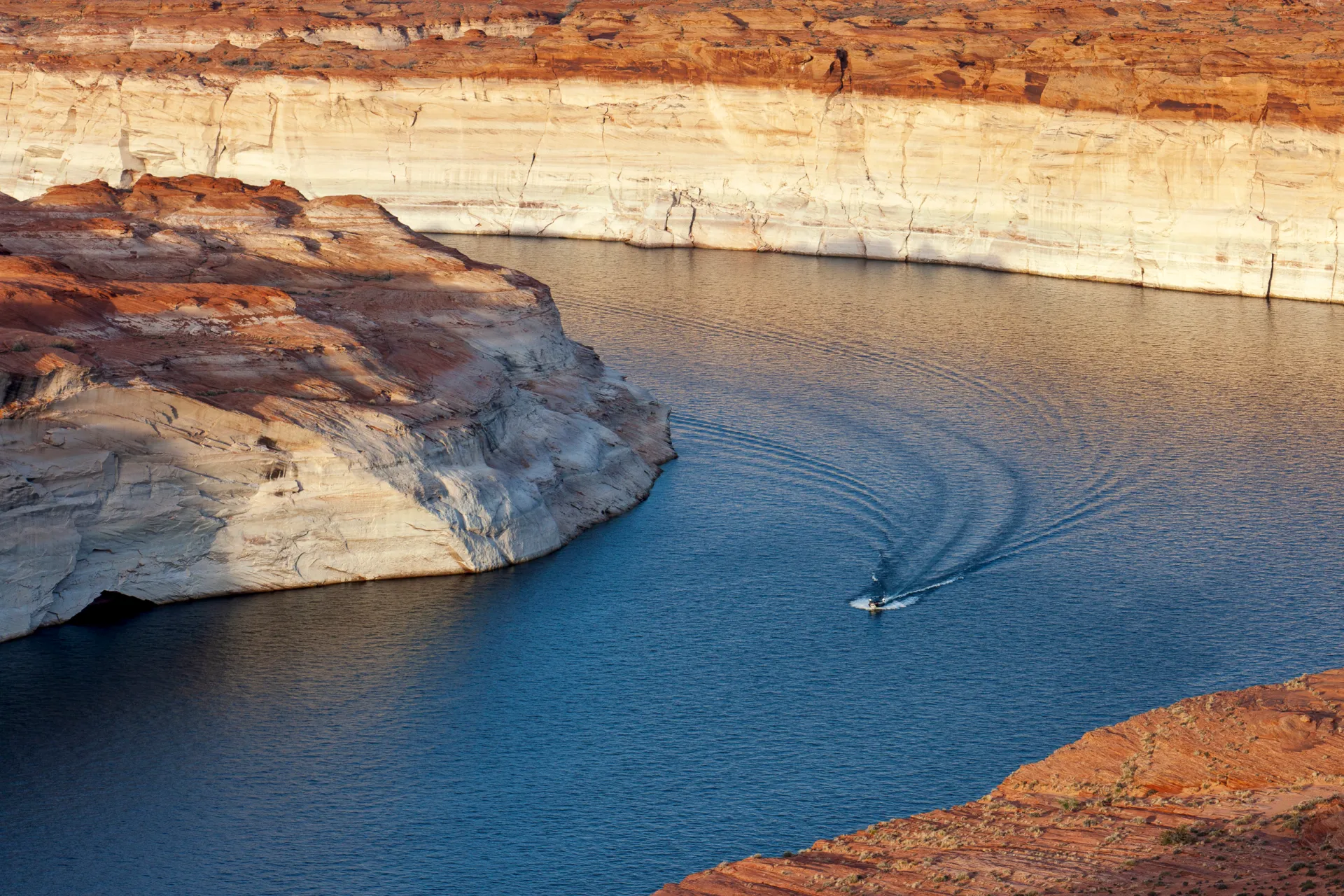
Lake Powell is formed by Glen Canyon Dam, a striking 710-ft tall concrete arch braced against ruddy sandstone walls. It plugs the Colorado just after the river enters Arizona. Meant to ensure water deliveries to the lower basin states of Arizona, California, and Nevada, Glen Canyon Dam was finished in 1963 to complement the Colorado River’s audacious engineering that distributes water through mountains and uphill to the largest cities in the Southwest and to the region’s most productive farmland. When full, Lake Powell holds enough water to flood the entire state of Virginia to the depth of one foot.
Climate change and water demand that still exceeds supply have flipped the engineering script. Lake Powell is less than 25 percent full today. Glen Canyon Dam, instead of being a guarantor of water, is now the most significant water chokepoint in the basin. The hard-won asset has become a glaring liability.
The back of Glen Canyon Dam circa 1964, not long after the reservoir had begun filling up. Here the water level is above dead pool, meaning water can be released via the river outlets, but it is below minimum power pool, so water cannot yet enter the penstocks to generate electricity. Bureau of Reclamation photo. Annotations: Jonathan P. Thompson
The reversal of fortune is because of how Glen Canyon Dam was designed. The dam was never meant to be operated at the extremely low water levels that Lake Powell is rapidly approaching. Doing so for extended periods of time could damage the pipes that move water through the dam, according to the Bureau of Reclamation, the federal agency that manages the structure.
Reclamation is now studying its options for retrofitting Glen Canyon Dam to accommodate a lower Lake Powell. It expects to release those findings later this year or in early 2027. As any home remodeler knows, renovating an aging structure is neither quick nor cheap, especially when failure could have disastrous consequences.
In the short term, Reclamation is relying on operational band-aids for Glen Canyon Dam and Lake Powell. With the consent of the seven states in the basin – Arizona, California, Colorado, Nevada, New Mexico, Utah, and Wyoming – the agency took unprecedented action this month to prop up the reservoir. Releasing more water from upstream reservoirs and holding back more in Powell will delay Glen Canyon’s infrastructure reckoning. But that day will soon come, and Reclamation’s answer to the dam’s engineering problems will have far-reaching implications – not only for the reliability of the basin’s water supply, but also for its power customers, ecology, and recreation economy.
An Assessment Deferred
Dams are difficult to manage under any circumstance. Management is even more troublesome when operators must balance multiple, conflicting objectives. In Glen Canyon’s case those objectives are water supply, flood control, hydropower generation, and releasing water to protect the ecology downstream in the Grand Canyon – namely, beach-building and threatened native fish like the humpback chub. This is in addition to ensuring the safe operation of the dam itself.
How to operate Glen Canyon Dam and Hoover Dam, its larger downstream sibling, is what the seven basin states and Reclamation are attempting to figure out right now. The current agreement covers operations through 2026. Reclamation published a draft environmental impact statement, or EIS, in January that would impose severe cuts on water users in the lower basin, particularly Arizona, in part to protect Glen Canyon Dam’s fragile infrastructure.
For that reason, water users in the lower basin and elsewhere support an engineering fix for Glen Canyon Dam. Many were incredulous that Reclamation did not include an assessment of dam modifications in its draft environmental analysis.
“This EIS could have been a great avenue to look at real changes at Glen Canyon Dam that could solve the water delivery problem and some of the ecological problems, too,” Balken said.
Patrick Dent is the assistant general manager for water policy at the Central Arizona Project (CAP), which delivers Colorado River water to the densely populated center of the state. He said that CAP does not favor any particular fix – only one that provides dam managers with more flexibility.
“Our primary interest is that they could release water at a lower lake level,” Dent said.
The Gila River Indian Community, which receives Colorado River water through CAP, told Reclamation that the agency has a duty to safeguard the tribe’s water rights, which are at risk if the dam cannot release enough water. “The United States must take action to fix Glen Canyon Dam,” Gov. Stephen Roe Lewis wrote in a March 2026 letter.
The Colorado Water Conservation Board, which represents that state’s water interests, said it supports a reevaluation of Glen Canyon Dam, but “in a separate action” from the EIS.
Becki Bryant, a Reclamation spokesperson, said the agency will release an appraisal study assessing three dam modification alternatives at the end of this year or in early 2027. Any action beyond the study, she said, requires congressional authorization and funding.
Illustration from the report, “Antique Plumbing & Leadership Postponed” from the Utah Rivers Council, Glen Canyon Institute and the Great Basin Water Network. Courtesy of Utah Rivers Council
‘Antiquated Plumbing’
The tool for managing the dam’s multiple objectives, which are a legislative requirement as well as a practical necessity, is the water held in Lake Powell, said David Wegner, a scientist who has worked on Glen Canyon policy for more than four decades. But even water has limits when the engineering is inadequate. “Sadly, these dams were not built for multiple objectives,” Wegner said. And Glen Canyon was certainly not built for extremely low water, he added.
The problem with Glen Canyon is what a coalition of environmental groups calls the dam’s “antiquated plumbing.” The groups – Glen Canyon Institute, Great Basin Water Network, and Utah Rivers Council – published a report in August 2022 that outlined these engineering deficiencies.
Water can exit Glen Canyon in only three ways. One is the spillways, a pressure-release valve for flooding, which are located at elevation 3,648 feet, near the top of the dam. They are irrelevant today. Lake Powell rests 122 feet below them.
The main exit point is through the eight penstocks, the 15-foot diameter tubes that move water through the turbines to generate hydroelectricity. The penstocks are incapacitated when Powell drops below 3,490 feet. (The lake today is 36 feet higher than that level.) If the lake falls below what is known as minimum power pool, hydropower generation also ceases.
If that happens, water must be released through four 8-foot diameter pipes called the river outlet works. Smaller than the penstocks, the river outlet works are located at elevation 3,370. Below that elevation water cannot be released from Powell, a status known ominously as “dead pool.” (Functionally, the river outlet works may be useless at elevation 3,394, Reclamation says.)
The environmental groups identified two limitations with the river outlet works. One is that they were not designed to be operated full-time. They are a role player, not the star. The other is that their smaller size means less water can pass through them. That’s a problem because the upper basin states of Colorado, New Mexico, Utah, and Wyoming are required to send a set amount of water downstream to the lower basin, according to the 1922 Colorado River Compact that divided the river.
The flow restrictions imposed by the river outlet works, if they had to be used full time, means that the upper basin could violate the compact, which could mean water cutbacks imposed by the lower basin.
“It’s just so counterintuitive that the tool that was designed to meet this delivery obligation” – the construction of Glen Canyon Dam – “is now going to be the roadblock that may prevent the delivery obligation from being met,” said Balken of the Glen Canyon Institute.
The engineering problems are not a new discovery. Wegner, who was with the Bureau of Reclamation at the time as its Grand Canyon environmental studies manager, helped lead a 1987 National Academies report on Glen Canyon. The report recommended that the Interior Department consider the “installation and operation of multiple outlet structures” at Glen Canyon, which would give dam managers more flexibility with water releases.
Glen Canyon’s structural problems were substantiated in 2023, when Reclamation used the river outlet works during an experimental “high-flow” release of water to flush sediment downstream and rebuild eroding Grand Canyon beaches.
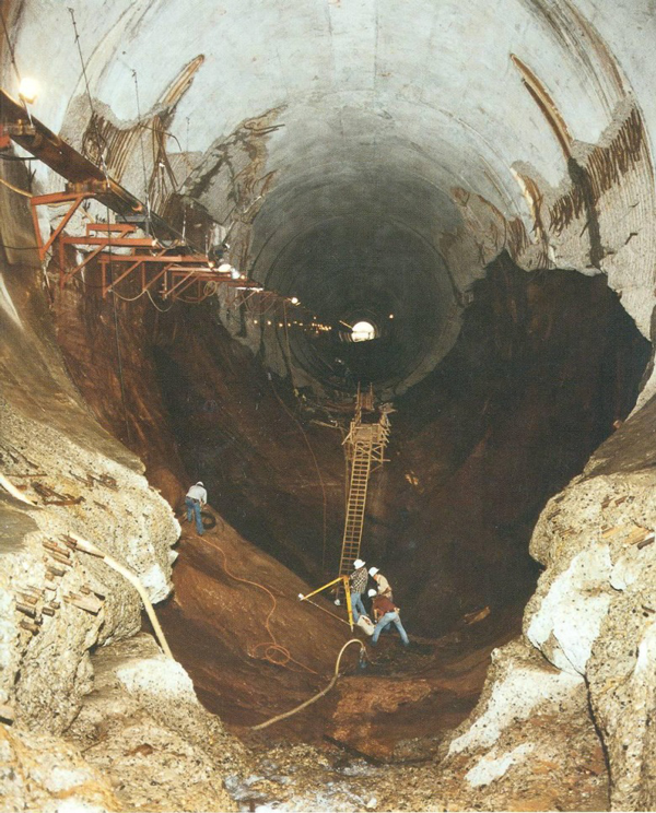
The high-volume release caused pitting, or cavitation, within the river outlet works, a risk that was heightened due to the physics of water when Lake Powell is low. Reclamation coated the pipes with epoxy as a temporary fix to prevent more damage, a process that took several months. The agency has since used two small-scale physical models at its Technical Service Center in Denver to test dam operations at low water levels and the effect on infrastructure.
Reclamation acknowledged the limitations of the river outlet works in a technical memopublished in March 2024 by Richard Lafond, director of the agency’s Technical Service Center. The memo’s conclusions were endorsed by the top decision-makers in Reclamation’s Upper Colorado River Office.
“Long term operation of the river outlet works will result in accelerating regular operation and maintenance tasks,” LaFond wrote. Reclamation should “not rely on the river outlet works as the sole means for releasing water from Glen Canyon Dam.”
Wegner put it in starker terms. If the river outlet works had to be relied upon and the pipes began to erode again, then Reclamation could potentially lose control of water flows.
“Potentially that could fail,” Wegner said, meaning an inability to control water releases through the dam if the pipes are structurally compromised. “And if that fails, now you have a catastrophe on your hand and you have limited options to manage that catastrophe.”
In other words, there would be no way to release water downstream into the Grand Canyon and into the lower basin.
Neither Quick Nor Easy
What fixes are possible? Reclamation received $2 million from Congress in the fiscal year 2022 budget for an appraisal study.
Reclamation outlined three engineering possibilities in a 2023 presentation, most of which centered on preserving hydropower generation as Lake Powell declines.
One possibility is a new, lower intake that uses the existing power generation turbines. An intake located deeper in the reservoir would allow Glen Canyon to pass water in what is currently dead pool. But it would entail “increased risk from penetration through the dam.”
The second would connect new power generation equipment to the river outlet works.
The third option is tunneling through the canyon wall and installing a new underground power station. This would also provide more flexibility for water releases.
Reclamation also included three operational or policy changes for power production, including investing in wind and solar to offset hydropower declines.
Other ideas that seemed kooky and fringe just a few years ago – draining Lake Powell and filling Lake Mead first; changing the basin’s water accounting system – are now being discussed throughout the basin with more seriousness and candor.
Beyond that presentation, Reclamation has not said much publicly about dam modification. The agency declined an interview request to discuss Glen Canyon Dam’s engineering problems.
Whatever direction Reclamation chooses – an option outlined above or something new – the process will not be quick or easy. Any change to Glen Canyon must go through an environmental analysis and public comment period. Congress will have to authorize actions and appropriate the funds. Construction alone will take years.
Wegner, who was the staff director for the House Natural Resources Water and Power Subcommittee from 2008 to 2014, knows the difficulty and sees a lack of leadership. “There’s nobody in Washington who has been willing to lead the charge trying to get Congress to provide authorized funding to do this sort of work.”
‘Reservoir Triage’
Because Reclamation is not confident it can operate the river outlet works for an extended run, the agency is focused on keeping Powell above elevation 3,500 feet.
Protecting 3,500 feet comes with all sorts of baggage. It preserves hydropower generation, which power customers appreciate. But in effect the redline at that elevation strands some 4.4 million acre-feet in Lake Powell. (Only 3.7 million acre-feet is technically accessible with the current plumbing.) Some have called this elevation a “de facto” dead pool. Thus, the agitation in the lower basin for a plumbing system within the dam that provides access to this water.
Balken said that downstream water deliveries, not preserving hydropower, should be Reclamation’s biggest concern.
“When these decision makers are talking about Glen Canyon Dam from only a hydropower perspective, I think it’s missing the larger point, which is the dam is about to become the biggest roadblock of water deliveries that the basin has ever seen,” Balken said.
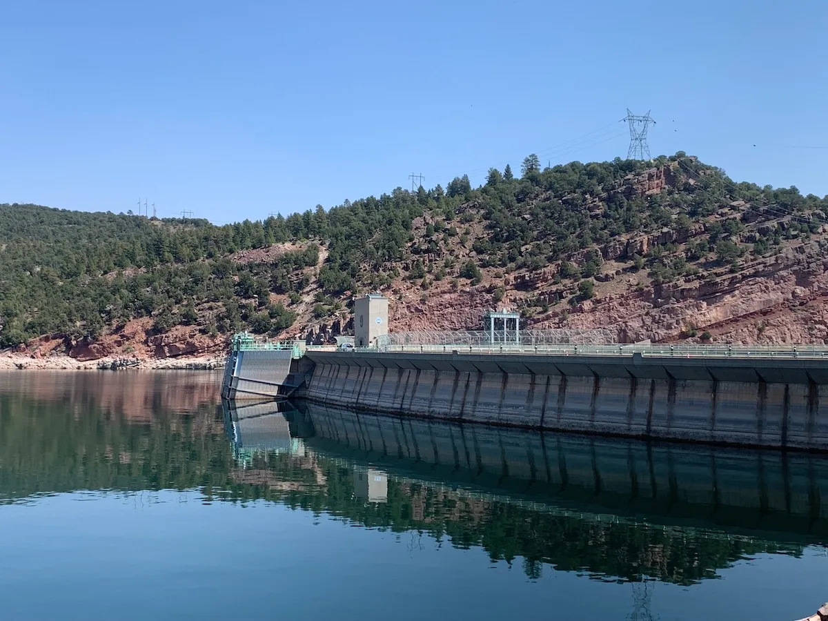
Flaming Gorge Reservoir, on the Green River, straddles the Wyoming-Utah border south of Rock Springs. The Flaming Gorge dam, on the Utah side, was completed in 1964 and is a critical component of the Colorado River water storage system. The Green River, the chief tributary to the Colorado River, originates in the Wind River Range, flows to Flaming Gorge Reservoir, then connects with the Colorado River in Canyonlands National Park in Utah.
To avoid the infrastructure risks of dropping below 3,500 feet, Reclamation has started to take extraordinary action. The agency has two emergency levers it is pulling. One is to hold more water back in Lake Powell. Reclamation cut water releases to the legal minimum this year, something it has never done. The other is releasing more water from Flaming Gorge, a reservoir upstream that is in better shape.
As Balken describes it, “This is reservoir triage.”
These emergency actions have serious side-effects. Upstream, Flaming Gorge is expected to lose 35 feet of elevation by next spring, once the extra water has been released. That will hurt the recreation economy of northeastern Utah and southwestern Wyoming – fewer boat ramps in the water, less fishing access.
These upstream releases have limited utility, Wegner said. “You can do that once or twice. But you got to then depend upon Mother Nature refilling those reservoirs upstream.”
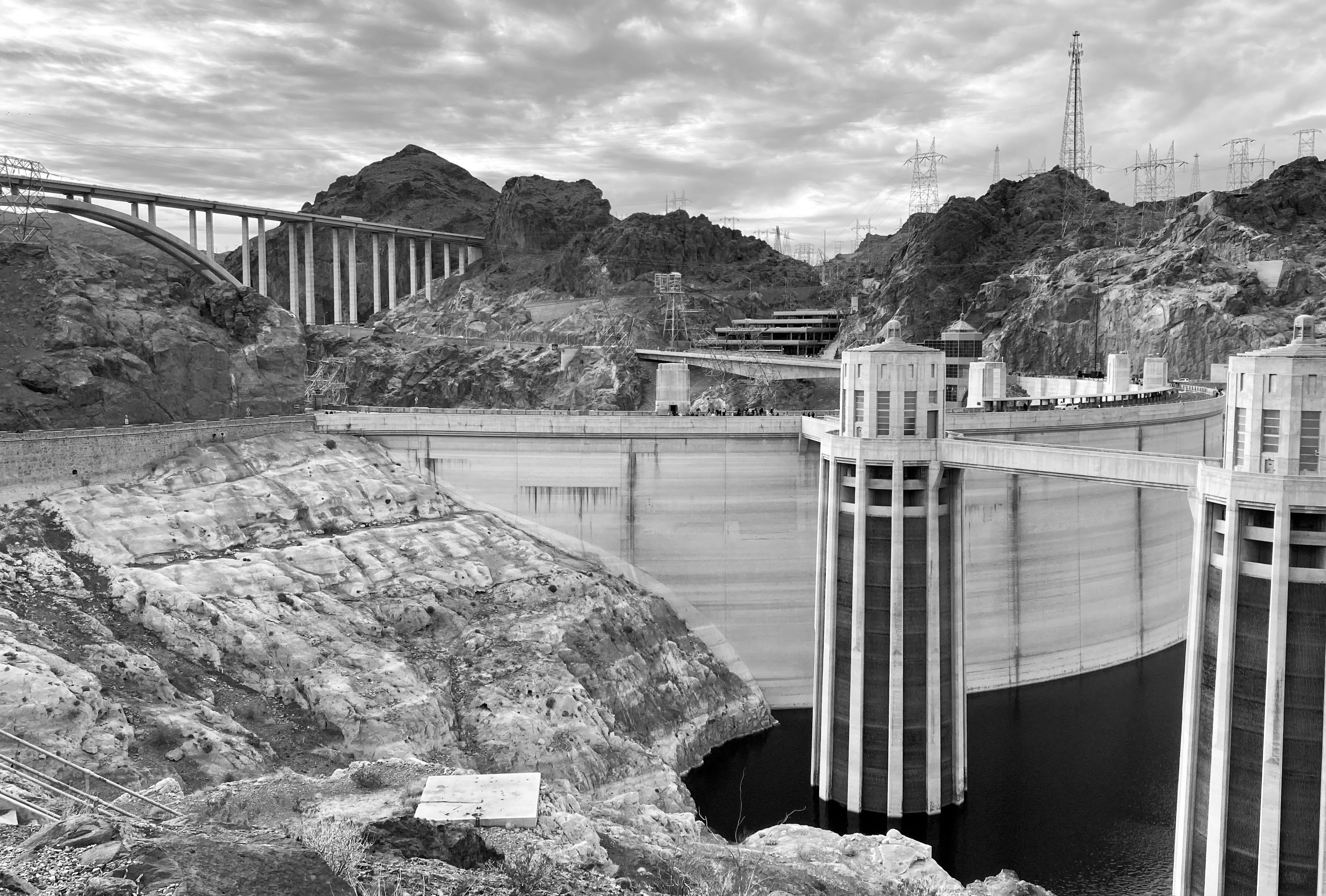
Hoover Dam at low water. Jonathan P. Thompson photo.
Downstream, Lake Mead will drop quickly and it too will approach a level in which hydropower generation at Hoover Dam severely drops. Algal blooms in a warmer, shallower lake could be a problem. “They’re going to be robbing Mead to pay Powell,” Balken said.
Trying Not to Hit Bottom
The idea of dead pool – when Lake Powell can no longer release water – was almost inconceivable when the reservoir was designed and filled. The official device for measuring Lake Powell’s elevation ends at the top of the penstocks, at elevation 3,477.5 feet. According to Reclamation’s 2024 technical memo, “This is an indication that reservoir elevations below minimum power pool” – 3,490 feet – “were not anticipated.”
Cavitation at the Glen Canyon Dam, the cause of the emergency in 1983 via Flow Science.
Reclamation finished filling the reservoir in 1980. Three years later, after an intense El Niño winter, the dam’s upper limits were tested. Floodwaters in the summer of 1983 nearly broke the dam. Such volumes are almost inconceivable now.
In a typical year, Lake Powell would be rising in late April, flush with the deposits of snowmelt from headwater basins in the Rocky Mountains. Not this year. The snowpack peaked in many basins in late February or early March. What little snow there was has already melted. As of April 28, Lake Powell inflows are projected to be just 16 percent of average. Lake level forecasts from mid-April showed a long downward slope for the next 12 months. Those projections were what triggered the emergency release of water from Flaming Gorge and the reduction in Lake Powell releases.
Scientists have been warning about circumstances like this for years. In a defining period for the basin, all the predictions of water supply shocks in the Colorado River from the past two decades are coming to pass.
“We should have been prepared for this,” Balken said.
Click the link to read the article on the Big Pivots website (Allen Best):
April 26, 2026
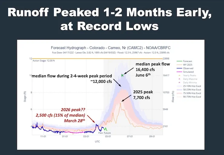
The staff at the Colorado River District showed this slide during a session on Colorado River hydrology at the district’s board of director meeting in Glenwood Springs this past Tuesday afternoon.
Here in metro Denver, the staff of Big Pivots said something profound like “holy moly!”
With moisture coming into Colorado during the next two weeks, it’s possible that the runoff into Lake Powell may surpass that of 2002. This slide says that right now, at Cameo, the gaging station on the Colorado River, east of Palisade, it looks like the spring runoff peaked in late March. The usual is in early June.
Another takeaway from the River District meeting was about Green Mountain Reservoir. The dam that creates the reservoir was built from 1938 to 1943, giving the Western Slope a way to store water as part of the Colorado-Big Thompson diversion that came after World War II. The normal allotment of the reservoir storage for downstream irrigators, mostly in the Grand Junction area, is 66,000 acre-feet.
For the first time in the history of Green Mountain, said Andy Mueller, the River District’s general manager, the water is unavailable. Instead, the river district is tapping various pools of water over which it has control to come up with a thimbleful here, a cup there. A creative solution, Mueller called it. Irrigators won’t become whole, but they will get some help.
“We’ll survive, and we will continue to survive,” said Mike Ritschard, a director from the Kremmling area and a fourth-generation rancher there, said during a roundup of reports from board members.
Created in 1937, one of the ramifications of the Colorado-Big Thompson water diversion, the River District has primary responsibility for water matters across 15 of the 20 Western Slope counties.
The Colorado River Water Conservation District spans 15 Western Slope counties. Colorado River District/Courtesy image
When Donald Trump was elected president for the second time, we all knew what was coming to the nation’s public lands: The administration would favor extractive uses by eviscerating environmental protections, rolling back regulations, and leasing out as much land as possible while handing out drilling permits like Shriners throwing candy at a parade.
Yet there was one realm where I figured the administration couldn’t bestow any more deregulatory gifts, namely public lands grazing. It’s not that I thought Trump would clamp down on the destructive practice, it’s just that I figured the status quo was about as permissive as it could get. Past administrations, be they Democratic or Republican, have generally shied away from updating or reforming public lands grazing policies out of fear of inflaming the West’s cowboy culture — even if it is based largely on myth.
But Trump, his Interior Secretary Doug Burgum, and Agriculture Secretary Brooke Rollins are intrepidly going where previous administrations did not dare: grazing reform. Well, sort of, though maybe not in the way public lands lovers might have hoped. In fact, they are doing their best to make grazing policy even more lax with a goal of getting more cattle out there to trample public lands, cryptobiotic soils, and cultural sites.
Last month, Burgum and Rollins announced an MOU between the two agencies designed to “boost the supply of American born, raised, and harvested beef” by cutting “bureaucratic red tape” and giving the livestock industry more control. The MOU has a goal of “maintaining grazing capacity wherever possible, including no net loss of Animal Unit Months within allotments,” even if those allotments are degraded or in poor health. In Burgum’s words, one goal is to “preserve America’s ranching heritage for generations to come.” Forgive me for getting anxious whenever I see “heritage” used in conjunction with public lands.
“Today’s signing sends a clear message: the Trump administration is putting America’s farmers and ranchers first,” said Secretary of Agriculture Brooke Rollins. Which brings up the question of what message the administration was sending in February when Trump signed an executive order to quadruple beef imports from Argentina in an effort to keep Big Macs affordable.
🗺️ Messing with Maps 🧭
To help it carry out its mission, the Bureau of Land Management has released an interactive map aimed at putting more cattle and sheep back on public lands. The “federal grazing lands potentially available” map shows allotments that have been vacated, often as a result of deals brokered by environmentalists, with the intent of peddling the tracts to livestock operators. While there’s no guarantee that the BLM would lease out all of the vacant tracts, the presence on the map of the ones vacated for environmental purposes is enough to set off alarm bells.
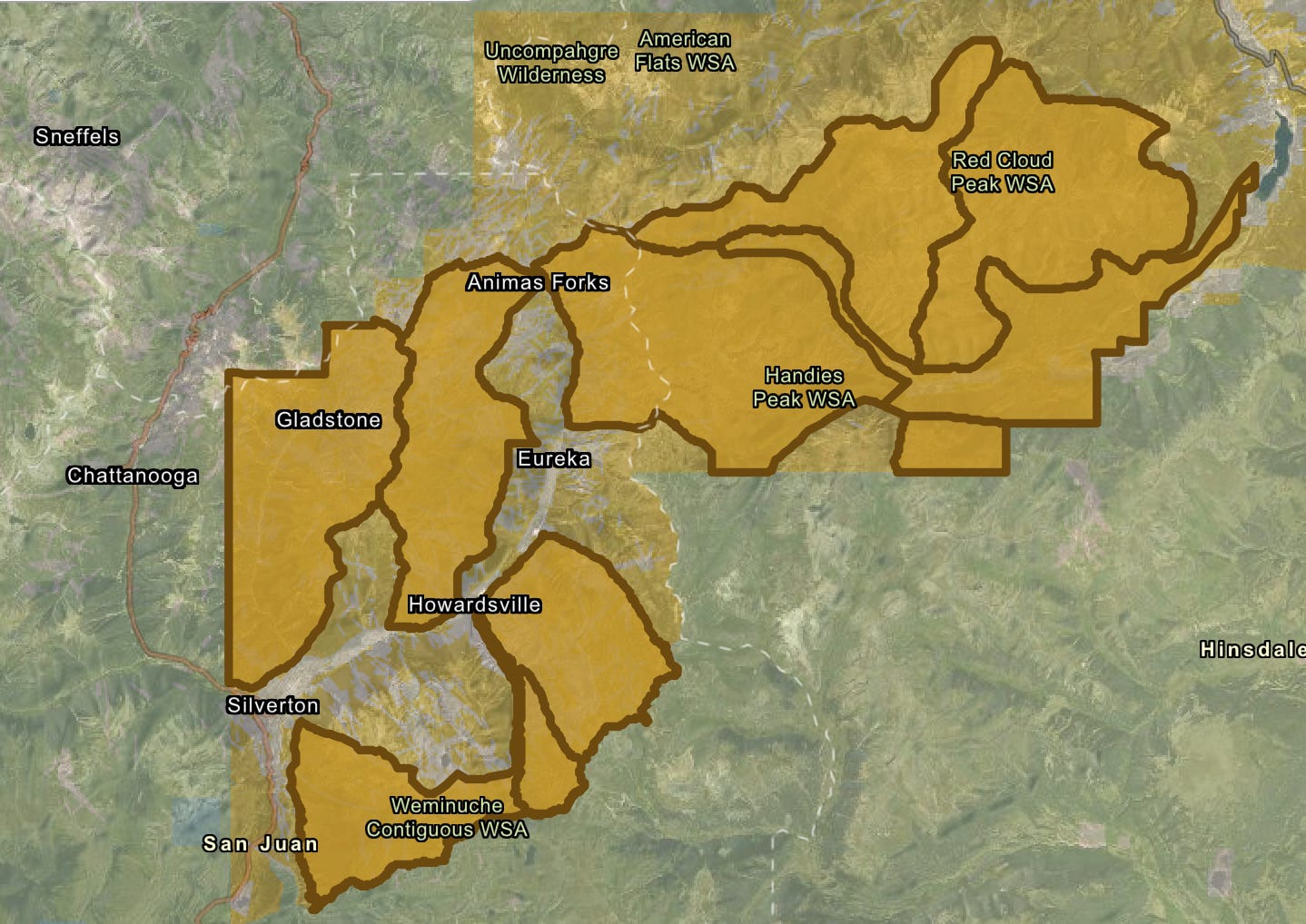
Grazing allotments listed as “potentially available” for leasing on the BLM’s new map. The five parcels closest to Silverton were retired in 2023 to protect bighorn sheep. Source: BLM
For example, the map includes 10 allotments in the high country around Silverton, Colorado, totaling about 70,000 acres. In 2023, the National Wildlife Federation paid the Etchart Sheep Ranch to vacate five of these allotments in an effort to give Rocky Mountain bighorn sheep more breathing room and protect them from diseases transmitted by domestic sheep. The deal was made with the hope that the leases would be retired permanently. Yet the inclusion on the map indicates they could see domestic sheep once again, emphasizing the need for legislation that would make such retirements perpetual.
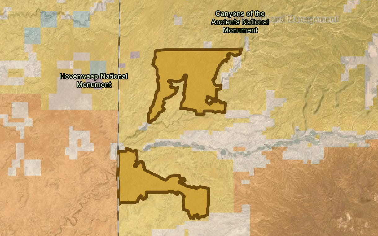
Also on the map are the Flodine Park and Yellowjacket allotments in Canyon of the Ancients National Monument near the Colorado-Utah border. In 2005, a rancher gave up the allotments, north and south of McElmo Canyon, respectively, and sold 4,500 acres of adjacent private land to the BLM to add to the national monument. Both allotments and the private land contain a number of intermittent streams, shallow canyons, and numerous cultural sites. They had been grazed relentlessly for decades prior, and showed the wear and tear—much of the cryptobiotic soil had long before been trampled and destroyed and invasive cheat grass had infiltrated the grazed areas. An archaeological assessment conducted later found grazing had damaged dozens of sensitive and cultural sites in the areas.
The Yellowjacket and Flodine Park allotments in Canyons of the Ancients National Monument. They have been vacant since 2005, and a previous effort to lease them out again was halted. Now it looks like they may be back on the block. Source: BLM
In 2010, the BLM, which manages the monument, issued a new resource management plan, which allowed for continued grazing, but also opened the door to permanently retiring vacant grazing allotments if they fail to meet BLM rangeland health standards or when grazing is negatively impacting cultural sites. Five of the 28 allotments in the most heavily visited areas—including Sand Canyon—were cancelled, but not the Flodine Park and Yellow Jacket allotments, which were still in retirement at the time.
Instead, the local county commissioners and a group of ranchers pressured the BLM to reauthorize grazing on both allotments—to bring them out of retirement, if you will. The BLM acquiesced, but environmentalists and tribes with roots in the area fought back, forcing the agency to do a more thorough environmental analysis of the proposal. The opposition was enough to prompt the agency at least to delay issuing any leases, and the allotments remain in limbo.
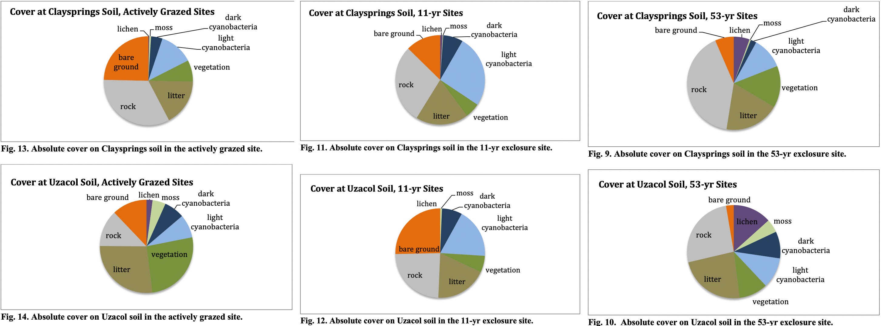
Meanwhile, a team of scientists assessed the healing process on the Flodine Park and Yellow Jacket allotments, which by then had been cow-free for 11 years (though feral horses had grazed there). They compared biocrusts on those allotments to a fenced enclosure that hadn’t seen grazing for 53 years and a plot that was being actively grazed. What they found was both predictable and remarkable: The longer a plot went without cows, the healthier it was, as summed up by these graphs.
Source: Grazing, Rest, and Biological Soil Crust in Canyons of the Ancients National Monument Marc Coles-Ritchie, Lior Gross and Mary O’Brien, Grand Canyon Trust.
While the natural landscape can eventually heal itself, livestock’s damage to the cultural landscape is irreversible. BLM surveys identified 266 cultural sites on the two allotments, including 35 with “standing architecture.” At least 43% of those had been damaged by livestock.
Now what’s left may be in danger, too, at least if those allotments’ presence on the new map is any indication. And guess what? Packing these allotments isn’t going to make that steak any cheaper. Only about 1% of American beef is grazed on public lands.
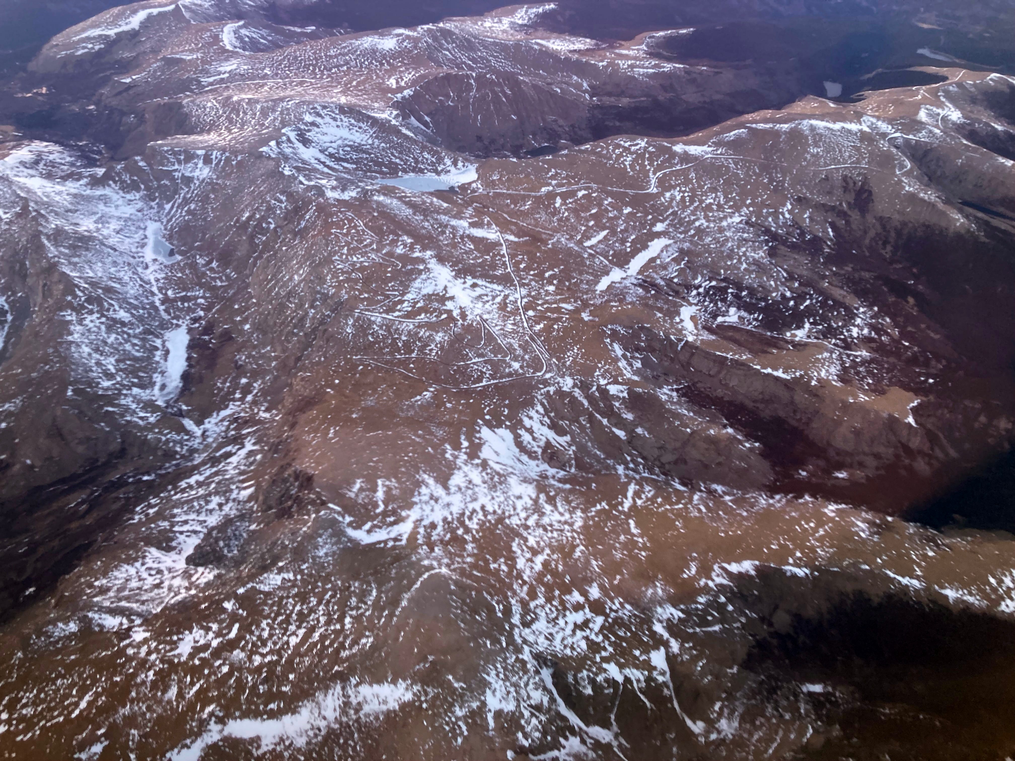
Mt. Blue Sky at 14,130 feet in elevation on April 22, 2026. Jonathan P. Thompson photo.
⛈️ Wacky Weather Watch ⚡️
If you were to get all of your information about the West’s climate from daily weather reports and road condition websites, you might think that April snow showers and deep freezes had ended the snow drought and would lead to big May streamflows. After all, it snowed enough in Colorado to turn roads to slip-and-slides and causing a 75-car pileup on I-70 near the Eisenhower Tunnel. The temperatures dropped low enough to wipe out most of the fruit blossoms the March heat wave tricked into blooming early. Only the farmers who used extraordinary measures — starting fires or smudge pots in the orchards, running wind machines, etc. — could save some of their summer harvest.
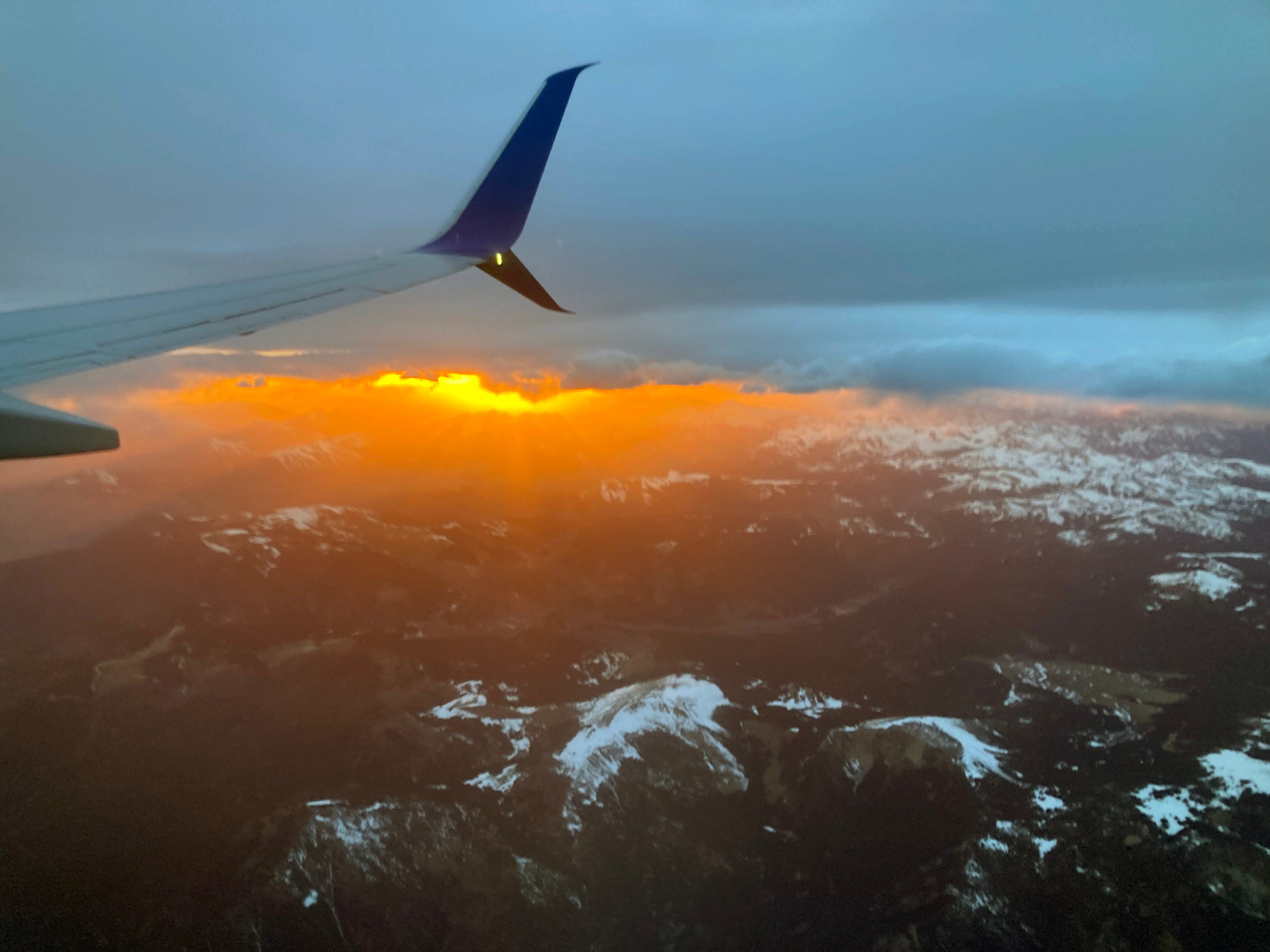
Sunset over the San Juans. Jonathan P. Thompson photo.
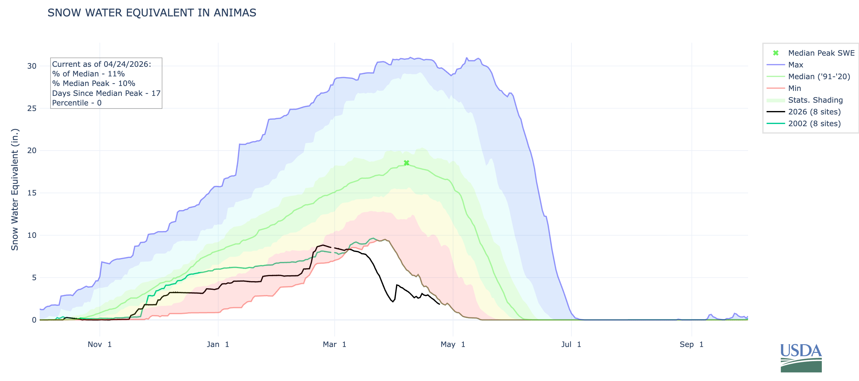
Sure, the snow that did fall in April helped, but only enough to elevate snowpack levels to, well, the lowest on record (only by a slightly smaller margin than before). And the freeze was deep, which helped extend the spring runoff in the few areas where there was any snow left. But even there, I suspect that peak runoff has already come and gone (though I’m not calling the Predict the Peak contest yet!).
I flew over Colorado’s mountains the other day and was rather shocked at the dearth of snow, even on the highest peaks. Mt. Blue Sky, formerly Mt. Evans, had only a few patches of white left — at 14,130 feet in elevation. Everything below 10,000 feet appeared to be snowless. While the San Juan Mountains appeared to be in slightly better shape, it was still looking pretty dry. The Animas River watershed’s snowpack remains lower than it was on 2002 on this date.