Click on a thumbnail graphic to view a gallery of drought data from the US Drought Monitor website.

Click the link to go to the US Drought Monitor website. Here’s an excerpt:
This Week’s Drought Summary
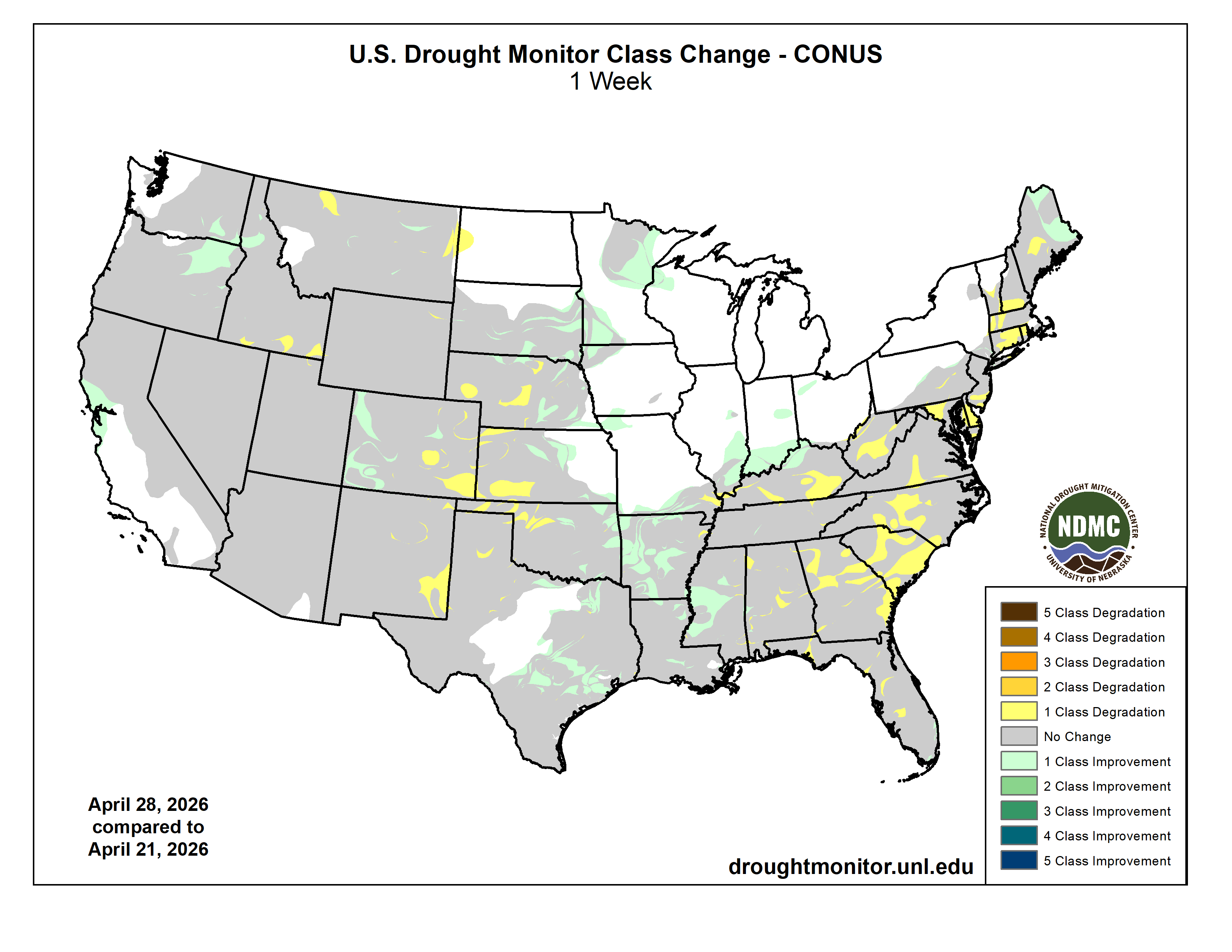
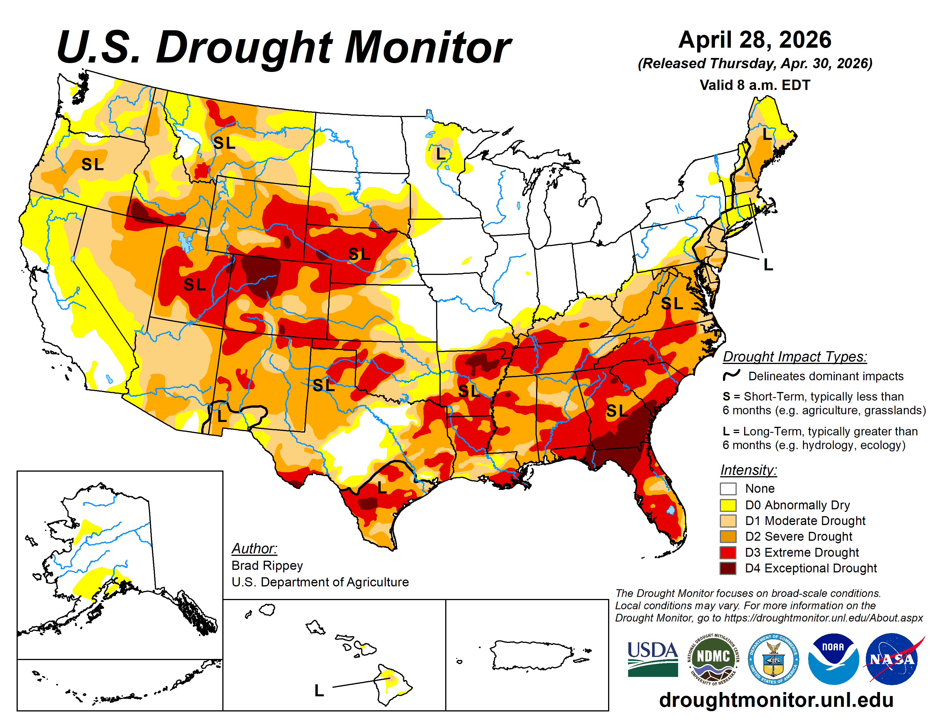
Rain continued to bypass the central and southern High Plains, leaving rangeland, pastures, and winter wheat in desperate need of moisture. Farther east, however, showers and thunderstorms continued to ease drought across the eastern Plains, extending into the mid-South and Mississippi Delta. Some of the heaviest rain, accompanied by locally severe thunderstorms, fell from eastern Kansas into the lower Midwest. The remainder of the Midwest also received some precipitation, although some of the region’s wettest areas in the Great Lakes States got a break from the excessive rain that had led to pockets of record flooding earlier in the month. In contrast, much of New England and northern sections of New York were cool and dry. Elsewhere, unsettled, showery weather prevailed in the West, mainly north of a line from central California to the central Rockies, boosting topsoil moisture, delivering high-elevation snow, and reducing irrigation demands. However, any precipitation did not fundamentally change a mostly bleak Western water-supply outlook for the remainder of the spring into the summer of 2026…
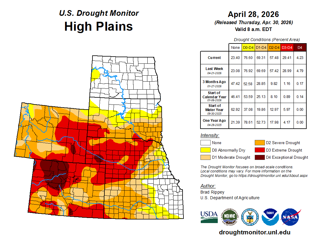
High Plains
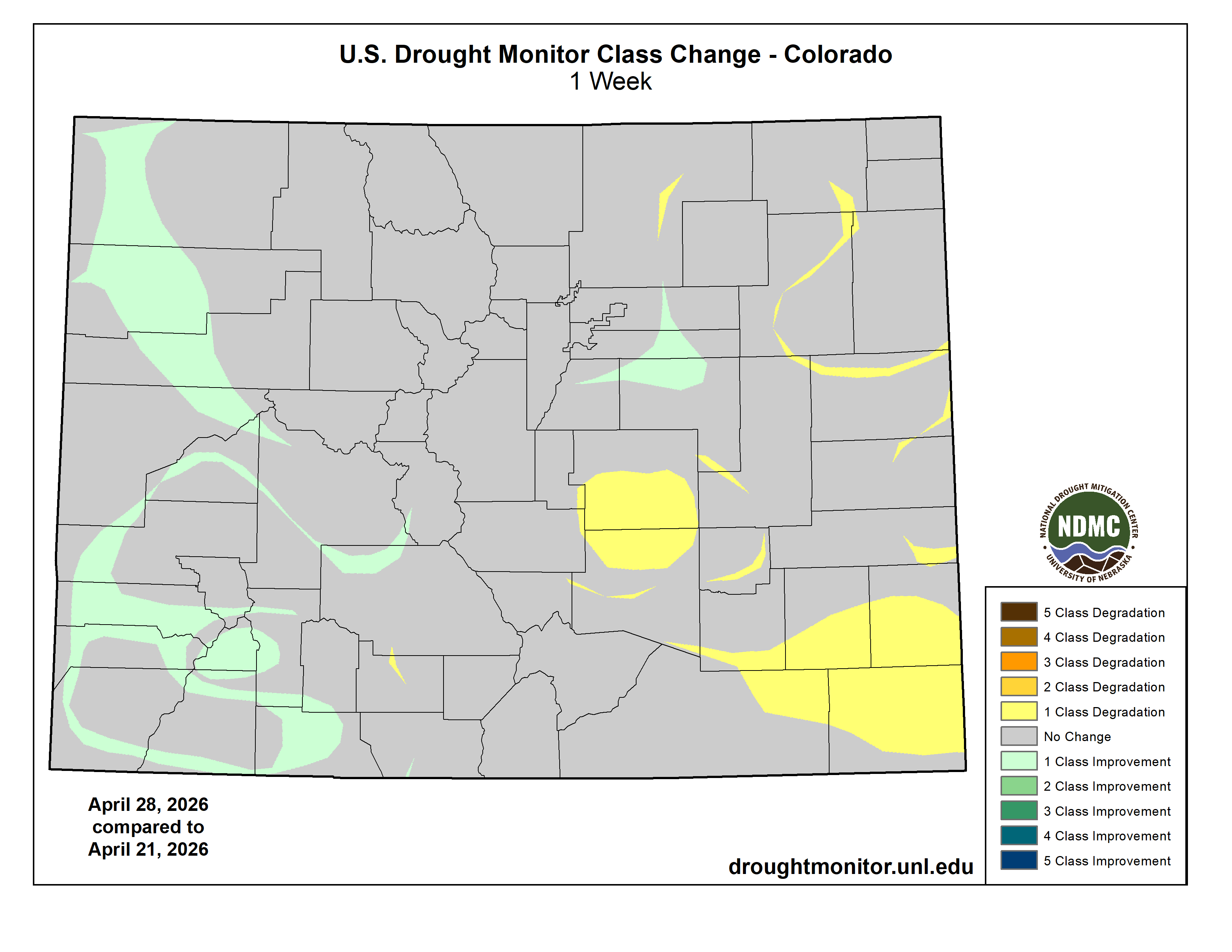
Precipitation delivered drought relief to some areas, including parts of southern South Dakota and eastern sections of Nebraska and Kansas. Still, by April 26, topsoil moisture—as reported by the U.S. Department of Agriculture—was rated at least 40% very short to short in all the region’s states, except North Dakota, and led by Colorado (95%). Winter wheat continued to struggle due to drought and recent freezes, with 65% of Nebraska’s crop rated in very poor to poor condition on April 26, along with 54% in Colorado and 41% in Kansas. Drought continued to generally worsen in eastern Colorado and western sections of Kansas and Nebraska…
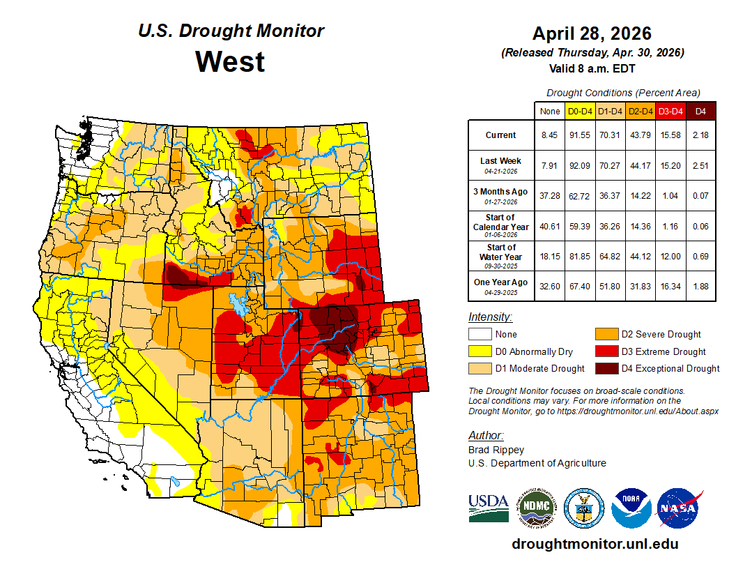
West
Any changes in the West were mostly minor and mixed, as cooler weather prevailed and spotty precipitation occurred. In most areas, Western precipitation did not alter bleak water-supply prospects, since most of the mountain snowpack has already melted, except in the northern Rockies. Already in late April, fears of an hydroelectricity generation crisis in the Colorado River Basin have led the Department of Interior to start sending water from Flaming Gorge Reservoir downstream to Lake Powell to help boost water levels. The Department of Interior also indicated that water normally destined for Lake Mead, farther downstream, would be held in Lake Powell. Despite overall lack of impact on Western supplies, any precipitation was largely welcomed, due to positive impacts such as a boost in topsoil moisture and a reduction in irrigation demands. In fact, enough precipitation has recently fallen to warrant a slight reduction in drought intensity in a few areas, including parts of western Colorado, northeastern Oregon, and southeastern Washington…
South
Late in the drought-monitoring period, significant rain overspread portions of the South, resulting in broad reductions in drought intensity. Some of the heaviest rain fell from eastern sections of Oklahoma and Texas into portions of Arkansas, Mississippi, and northern Louisiana. Still, more rain will be needed to ensure full drought recovery, since many of the hardest-hit areas had slipped into extreme to exceptional drought (D3 to D4) in recent weeks. Meanwhile, western sections of the South—including western Oklahoma and western Texas—remained critically dry, leading to poor rangeland, pasture, and winter wheat conditions, as well as a chronically elevated wildfire threat. Statewide, winter wheat in Texas was rated 56% very poor to poor on April 26, along with 45% in Oklahoma…

Looking Ahead
During the next several days, active weather across the South should lead to 1- to 4-inch rainfall totals from much of Texas to the southern Atlantic States. However, some Southern thunderstorms may produce large hail, damaging winds, and isolated tornadoes. The moisture will have a sharp northern edge, with little or no precipitation expected during the next 5 days across the northern and central Plains and Midwest. Generally dry weather will also cover the West, aside from late-season snow in the central and southern Rockies. Elsewhere, a cool pattern across the nation’s mid-section will strengthen, with frost and freezes possible into the weekend across the northwestern half of the Plains into the upper Midwest. By Saturday morning, scattered frost could extend as far south as the Ohio Valley and the southern High Plains.
The NWS 6- to 10-day outlook for May 5 – 9 calls for the likelihood of cooler-than-normal conditions in most areas east of the Rockies, while warmer-than-normal weather will be confined to an area stretching from the Pacific Coast to the northern Rockies, including the Great Basin and northern Intermountain West. Meanwhile, near- or below-normal precipitation from the Pacific Northwest into the upper Midwest should contrast with the likelihood of wetter-than-normal conditions across the remainder of the Lower 48 States.