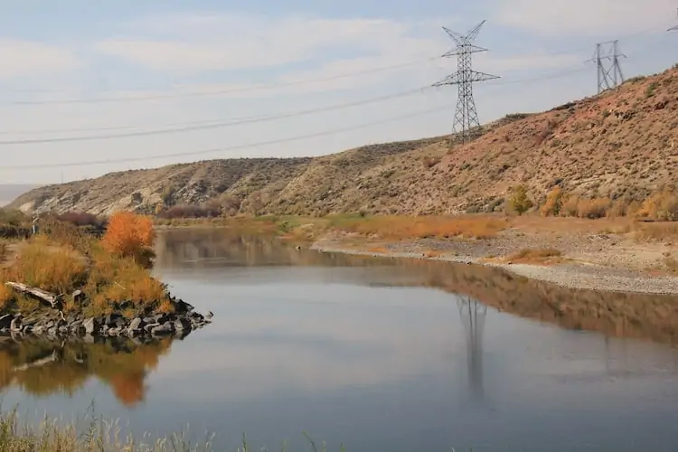
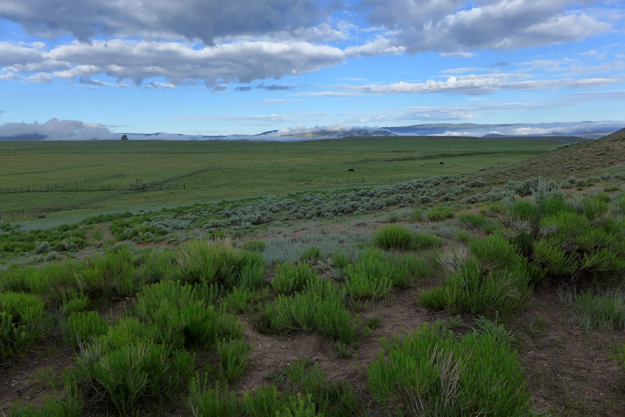
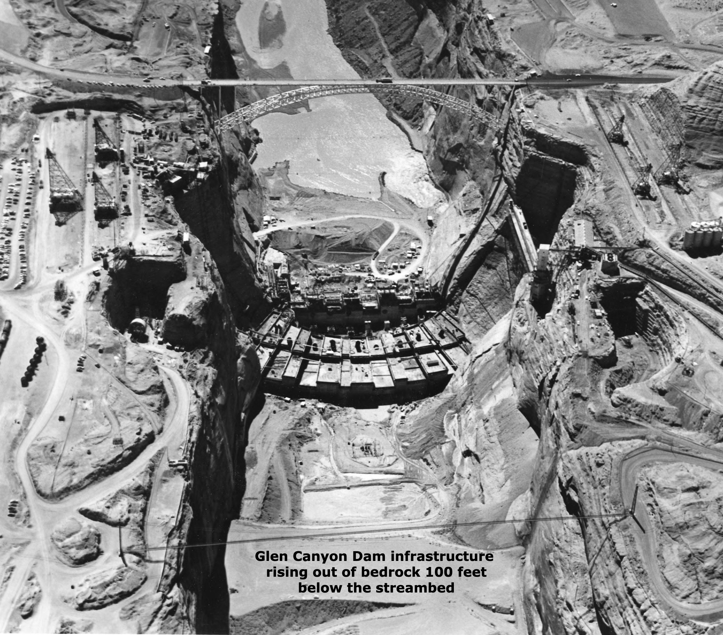
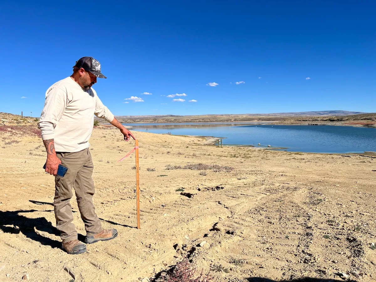
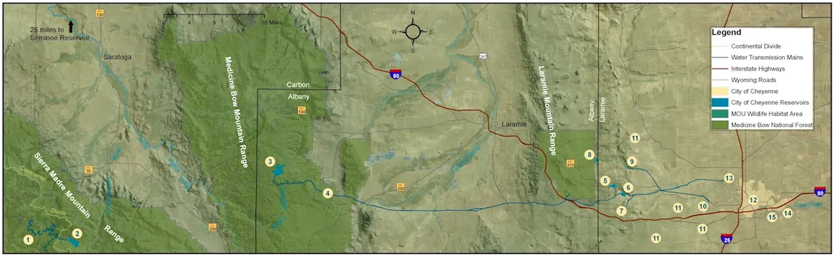
The size of Wyoming’s proposed and controversial West Fork Dam in the Medicine Bow National Forest in Carbon County is in flux as federal environmental analysts juggle economics and conservation in a review of the planned 264-foot high concrete structure, key analysts say.
As now planned, the structure would flood 130 acres and hold 10,000-acre-feet of water on a headwaters tributary of the Colorado River Basin where drought and climate change plague a river system that supports 40 million people. The dam’s reservoir would hold enough water to supply 20,000 households for a year but it would be used principally to benefit a few dozen irrigators, federal and state documents show.
Releases from the proposed reservoir would flow down Battle Creek to irrigators in the Little Snake River Valley in Wyoming and Colorado. But Wyoming’s plan has drawn public scrutiny and controversy over its purported benefits and impacts.
Studies and analysis reveal that some parts of the plan are uneconomical, officials with the U.S. Natural Resources Conservation Service said last week. That’s leading the agency to consider reducing the cost and scope of the project, cutting the amount of water to be impounded and also employing irrigation conservation measures, federal analysts said.
Even as reviewers flesh out various ways to supply irrigators with late-season water, along with some public benefits and habitat improvements, Wyoming’s design remains “one of the leading alternatives,” said Shawn Follum, an engineer with the federal conservation service.
As envisioned by the Savery-Little Snake Water Conservancy District, Colorado’s Pothook Water Conservancy and the Wyoming Water Development Office, the 700-foot-long dam near the confluence of Battle and Haggarty creeks would span a gorge and back up water for almost two miles.
Project backers estimated in 2017 that the entire project would cost $80 million, most of which the state of Wyoming would fund.
Some alternatives being considered in the environmental impact statement are “just not economically viable,” Follum said. “There’s no net benefit to the government.
“There’s a possibility of maybe changing the scope of that dam a little bit as we’re going through some of the economics to try to reduce some costs,” he said.
“We haven’t identified a modified West Fork [Dam] that’s practical yet,” Follum said. “But we are looking at [whether] we [can] reduce the need of the impounded water with some conservation measures, like lining a ditch to reduce seepage.”
Ongoing studies could propose a smaller project: “That’s what we’re hoping,” he said. But analysts haven’t resolved that size issue, Natural Resources Conservation Service public affairs specialist Alyssa Ludeke said.
“We just don’t have the final answer on that yet,” she said.
December deadline
A draft environmental impact statement likely won’t be completed and released for public comment until December, the two officials said in a telephone interview. The federal conservation service began reviewing the project in December 2022, coordinating with other federal and state agencies, including the Wyoming Water Development Office, the Medicine Bow National Forest and the Wyoming Office of State Lands and Investments.
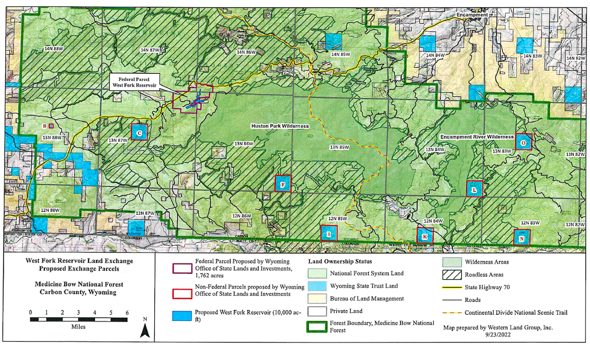
The state lands office proposed exchanging Wyoming property located inside the Medicine Bow for federal property at the dam site, a swap officials said would expedite environmental reviews. Wyoming sought 1,762 acres of federal land in exchange for an equal value of state property — until last month.
That’s when Jenifer Scoggin, director of the land office, reduced Wyoming’s proposal by 272 acres, or about 16%.
Wyoming’s Office of State Lands and Investments proposed this 1,490-acre Forest Service parcel be traded to Wyoming to enable construction of the West Fork Dam. the parcel is 16% smaller than Wyoming’s original request. (OSLI via Medicine Bow National Forest)
The amendment to seek only 1,490 acres was “based on discussions with the U.S. Forest Service,” Scoggin wrote Jason Armbruster, Bush Creek/Hayden District ranger with the Medicine Bow. The change “addresses resource issues” identified by field studies, she wrote.
Some of the parcels the state sought required Wyoming to surmount “larger hurdles than we could jump,” said Jason Crowder, deputy director of the state lands office.
“We’ve been working for the past year or so trying to come up with a package of land that would move easily through the federal exchange system,” he said in an interview. “It just made sense to change the make-up of the parcels involved [to follow an] easier path.”
The Medicine Bow will use the updated Wyoming proposal as the basis for a “feasibility analysis,” forest spokesman Aaron Voos wrote in an email. That finding — whether the exchange is possible — is the first of two steps.
If the swap is feasible, the Medicine Bow would then determine whether it is in the public interest.
Alternatively, the environmental review might suggest that the state construct and operate a reservoir under a federal permit instead of acquiring the land underneath and surrounding the dam and reservoir. Wyoming has not favored that path.
The Natural Resources Conservation Service and U.S. Forest Service continue their independent reviews.
“I believe the land exchange will probably be slower than the EIS itself,” Follum said. “But that won’t impact [us at the conservation service] because we’re going forward with the kind of a dual assumption; it’ll either be a land exchange or permit.”
The conservation service identified six alternatives when it announced its environmental review, including a no-action alternative. Three other alternatives consider building the dam as proposed under a Forest Service permit or through a land exchange. A fifth option calls for locating a reservoir elsewhere and a sixth calls for water conservation and habitat-improvement projects.
A major project to update the Maybell Diversion and headgate on the Yampa River is nearing completion as its users prepare for irrigation season. The Nature Conservancy, Maybell Irrigation District and JHL Constructors have worked together on the $6.8 million endeavor, which makes possible the first remote operation of the headgate in over 126 years.
Maybell is home to one of the largest irrigation diversions on the Yampa River. It provides water to about 2,000 acres of irrigated hay meadows in Northwest Colorado through a series of lateral ditches that come off the Maybell Diversion located just west of Craig toward Dinosaur National Monument…In the past, the headgate was manually operated, requiring a 3-mile round-trip hike and special tools and equipment to open the gates to the ditch. This often meant water was not used efficiently or at the most opportune times for ranchers. In addition, the Maybell Diversion has previously posed challenges for both fish and recreational boat passage through that part of the river in Juniper Canyon. In the past, fish movement was constrained by low river flows, especially during irrigation season. The Maybell reach has been considered a recreational-use hazard due to landslides, large boulders that block the river and push-up dams that hinder fish and boaters alike.
The newly modernized diversion and headgate will allow for remote operation and improved water delivery control to agricultural lands. It also aims to improve fish passage and recreational boat access. The redesign will connect two sections of floatable river with a constructed riffle at the diversion.
“We are excited to have this project completed,” said Mike Camblin, president of the Maybell Irrigation District. “Water is a precious resource, and this project allows us to manage it in the way the 21st century demands. We’re grateful to our partners, The Nature Conservancy, JHL Constructors and others who made this possible.”
Power distribution lines in the Yampa River Valley October 2020. Photo credit: Allen Best/Big Pivots
Click the link to read the article on the Big Pivots website (Allen Best):
April 18, 2024
Bill moving through Colorado Capitol that would allow Xcel Energy and Tri-State G&T to keep water rights for 20 years after last coal plant closes
Colorado’s Yampa River Valley has five coal-burning units that will cease operations from 2025 to 2030. Two are at Hayden and three are at Craig. All require water for cooling.
What will become of that water once the coal plants close?
SB24-197, a bill that is rapidly moving through the Colorado Legislature, would allow Xcel Energy and Tri-State Power and Generation to hold onto their water rights, even if they are not using them, until 2050. That is a precedent-setting exception to Colorado’s famous use-it-or-lose-it provision in water law.
The utilities say they may very likely need the water once they figure out how they will replace the coal generation. Neither utility has announced specific plans, but in response to a question at the bill’s first hearing in a Senate committee last week, Xcel Energy’s Richard Belt identified pumped-storage hydro and hydrogen as leading candidates. The federal government has devoted considerable funding and support for development of both technologies, he said.
“Those are the two leaders,” said Belt. “There aren’t many on the horizon that would fill the niche in that decree.”
Both technologies would provide storage. Xcel and other utilities are on their way to having massive amounts of cheap renewable energy. Still to be solved is how to ensure reliability when winds quiet for long periods. And the sun, of course, always goes down.
Storage will be essential and perhaps some kind of baseload generation. Xcel’s current plans call for an increase in natural gas capacity to ensure reliability even if the natural gas plants are used only infrequently, say 1% or 2% of the time. Xcel Energy is also adding literally tons of four-hour lithium-ion battery storage.
Cabin Creek pumped hydro reservoir. Photo credit: EE Online
The company’s biggest storage device is still its oldest, the 324-megawatt Cabin Creek pumped storage unit. Water from the upper reservoir is released to generate electricity when it is needed most, then pumped back uphill when power is relatively plentiful.
A developer has secured rights from landowners at a site between Hayden and Craig. See story. Another pumped-storage hydro possibility has been identified in the area between Penrose and Colorado Springs.
Hydrogen has less of a track record, at least in Colorado. However, it is part of Colorado’s all-of-the-above approach. See story. Hydrogen can be created from natural gas, but to meet Colorado’s needs it must be created from water. It would then be stored. Like pumped-storage hydro, it would be created when renewables are producing excess electricity, and the hydrogen could then be tapped to create electricity when needed most. That electrical generation would also use water for cooling, Belt said.
The bill, said Belt, proposes to allow Xcel the time for the economic and feasibility details of these emerging technologies to be resolved “instead of forcing a near-term decision driven by the processes of current water law.”
Normally, utilities would be required to demonstrate purpose of water, which can take several years, or risk abandonment. Because they will not have to, some see this as allowing the utilities to speculate. The utilities insist that it’s too soon to know exactly what their future water needs will be. But in addition to owning land in the Yampa Valley and water, they have expensive transmission linked to the rest of Colorado.
State Sen. Cleave Simpson, a Republican from Alamosa — and a former lignite coal-mining engineer, made note of that infrastructure on the floor of the Senate on Monday morning when he spoke in favor.
The bill will allow the utilities to hold onto the water in Western Colorado “so the region can have a true just transition and so hopefully it can continue to be an energy producing
region using existing infrastructure.” Upon advice of the Colorado Attorney General’s Office, the bill was amended by the Senate to specify that the water must remain in the Yampa River Basin.
Coyote Gulch near the confluence of the Little Snake and Yampa Rivers July 2021.
Since Colorado adopted carbon reduction targets in 2019, there have been questions about what might happen to the water in the Yampa Valley. It’s not a huge amount of water, but it can matter in a basin that since 2018 has had several calls on the river after having none for the previous 150 years.
The issue was hashed out by the legislatively-created Drought Task Force in 2023. The task force called attention to the idea of allowing utilities to preserve their water rights until 2050, but the idea failed to get a full endorsement.
Sen. Dylan Roberts, a prime sponsor, explained at the Senate Agriculture and Natural Resources Committee meeting that additional work in recent months has produced legislation that has ended objections. Indeed, Western Resource Advocates supported the full bill, as did others.
Jackie Brown, who represented Tri-State on the task force, told the Senate committee members that the measures in SB24-197 “provide Tri-State certainty that our water resources remain intact and available for future dispatchable carbon-free generation as needed and is projected in our electric resource plan. While we continue our planning process, keeping this utility water in the Yampa River helps all water users, creating a win-win situation.”
The Glenwood Springs-based Colorado River District in 2021 conducted a study of what happens to water when released from the Elkhead Reservoir, which is located near Hayden. The study found that 14% of the water was picked up by irrigators, 10% was lost to transit – and the rest of it flowed downstream. That suggests what will become of this water while it is not used.
Downstream lie segments of the Yampa where endangered fish species live. Those stretches have become nearly non-existent during the hot and dry summers of recent years.
Routt County Commissioner Tim Corrigan said his county supports the bill. He said hebelieved that Moffat County did also. He emphasized that the solution will help the environment as well as other users. The energy transition in northwest Colorado, he said “will take place over a very long time.”
The bill also has provisions applicable across Colorado. It allows the owner of a decreed storage water right to loan water to the Colorado Water Conservation Board for a reach of river for which the board does not hold a decreed instream flow water right. It also requires the CWCB to establish an agricultural water protection program in each of the state’s water divisions.
Simpson, on the Senate floor, also explained that the bill would create what he called a much-needed program, crafting a pathway to loan water from water storage for a reservoir to benefit an instream flow program “without going through the whole CWCB process with getting an adjudicated flow.”
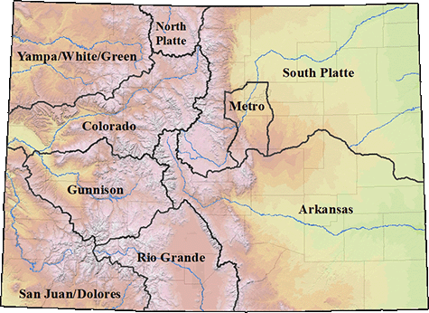
Yampa/White/Green/North Platte river basins via the Colorado Geological Survey
The coal-fired Tri-State Generation and Transmission plant in Craig is scheduled to close in 2028. Senate bill SB24-197 would allow the water rights associated with the plant to be protected from abandonment until 2050. Photo credit: Brent Gardner-Smith/Aspen Journalism
State lawmakers are considering a bill that would let two energy companies with coal-fired power plants in northwest Colorado hang on to their water rights even after the plants’ planned closures in 2028.
Senate Bill SB24-197 says that industrial water rights held by Xcel Energy and Tri-State Generation and Transmission Association Inc. will be protected from abandonment through 2050. Under Colorado law, a water right that is not being used could end up on an abandonment list, which is compiled every 10 years.
Abandonment is the official term for one of Colorado’s best-known water adages: Use it or lose it. It means that the right to use the water is essentially canceled and ceases to exist. The water goes back into the stream where another water user can claim it.
Supporters of the bill say this protection from abandonment would give the companies a grace period to transition to clean-energy sources and eventually use the water again in new methods of energy production. In the meantime, the water will remain in the stream for the benefit of the environment, recreation and downstream irrigators.
State Sen. Dylan Roberts, D-Frisco, is one of the bill’s sponsors, and represents Clear Creek, Eagle, Garfield, Gilpin, Grand, Jackson, Moffat, Rio Blanco, Routt and Summit counties.
“The idea is if we can find a way to ensure that the water rights of the power companies are protected over the next couple of decades, this will give them a stronger incentive to find a new way to produce energy in the region,” Roberts said.
Tri-State plans to shut down its coal-fired power plant in Craig in 2028, the same year that Xcel Energy plans to close the Hayden Generating Station, which has prompted questions about what will happen to the water currently being used by the facilities.
Jackie Brown is a senior water and natural resource advisor at Tri-State. She said the bill preserves future opportunities for economic development by energy utilities in Moffat and Routt counties.
“The measures in this bill provide Tri-State with certainty that our water resources remain intact and available for future dispatchable, carbon-free generation as needed and projected in our Electric Resource Plan,” Brown said in a statement. “While we continue our planning process, keeping the utility water in the Yampa River helps all water users, creating a win-win situation.”
According to Brown, the water used from the Yampa River by both energy companies is estimated to be about 44 cubic feet per second of flow. But, if the bill passes, engineers will officially quantify by 2030 the amount of water that the industries have historically used, and that is the amount that will be protected from abandonment. Any portion of the water rights that the energy companies lease to a third party would not be protected from abandonment.
The Yampa River begins in the Flat Tops Wilderness, flows through the city of Steamboat Springs and west through Routt and Moffat counties to Dinosaur National Monument, and eventually joins with the Green River. The Yampa River basin was one of the last to be developed in the state and in recent years has begun experiencing some of the issues long present in other areas such as shortages, calls, an overappropriation designation and stricter enforcement of state measurement rules.
In 2018, irrigators placed the first call on the river, triggering cutbacks from junior water users. When an irrigator is not receiving the entire amount of water to which they are legally entitled, they can place a call, which requires water-rights holders with younger water rights to stop irrigating so the senior water user can get their share. The Colorado River Water Conservation District, the Colorado Water Trust and others have made releases out of Elkhead Reservoir to get extra water to these senior downstream irrigators and keep the call off the river.
The Lefevre family prepares to put their rafts in at Pebble Beach for a float down the Yampa River to Loudy Simpson Park in Craig in June 2021. When the coal-fired power plants shut down in 2028, the water they currently use will be left in the water to the benefit of the environment, recreation and downstream irrigators. From left, Marcie Lefevre, Nathan Lefevre, Travis Lefevre and Sue Eschen. CREDIT: HEATHER SACKETT/ASPEN JOURNALISM
Support from environmental groups
SB 197 has gained support from environmental groups, including Conservation Colorado, The Nature Conservancy and Western Resource Advocates. Josh Kuhn, senior water campaign manager with Conservation Colorado, said leaving the water in the river will have environmental benefits such as lowering the often-too-high temperature of the Yampa, boost flows for recreation and the environment, and prevent calls on the river.
But the benefit to the river and water users from SB 197 may only be temporary. The energy companies will still own the water rights and may begin using them again whenever they want.
“It has been made clear that there’s no assurances that the water will be there on a permanent basis because Tri-State wants the ability to use that water to generate additional renewable clean-energy supplies in the future,” Kuhn said. “So there is a shared understanding that this is being done on a temporary basis.”
With the impending closure of the coal mines and power plants that by one estimate will result in 800 lost jobs, some see the Yampa River as an underutilized amenity that could supply recreation jobs and enhance quality of life. Supporters of the bill say keeping the energy companies’ water in the river and protected from abandonment will ensure that the water is not diverted out of the basin.
“The Yampa is already a river that suffers the impacts of climate-driven drought,” Kuhn said. “And so, in order to help protect that river and the economy that’s dependent upon it, they were looking for solutions to make sure that none of that water was exported to another basin.”
The protection of the energy companies’ water rights is just one facet of SB 197, which would also implement recommendations from last year’s Colorado River Drought Task Force. These include expanding the state’s instream-flow temporary loan program to let owners of water stored in reservoirs to loan it for the benefit of the environment in stream reaches where the state does not hold an instream-flow water right; expanding the state’s agricultural water rights protection program; and waiving the matching funds requirement for water project grants to the Southern Ute and Ute Mountain Ute tribal nations.
Roberts was the sponsor of 2023’s SB 295, which created the drought task force. Although the 17-member task force did not advance protections for industrial water rights from abandonment as an official recommendation (it failed on a 9-7 vote), it was included in the narrative section of the report that it provided to lawmakers.
“I’ve been working on this for months with the energy companies, with the state, with environmental groups and with local stakeholders in Routt and Moffat counties,” Roberts said. “And we narrowed the proposal significantly, and now almost everybody who was opposed on the task force is supportive of this idea moving forward.”
SB 197 passed unanimously in the Senate on Wednesday [April 17, 2024] and will now be up for approval by the House.
Children age five and younger, and women who are pregnant, planning to become pregnant or breastfeeding, are more susceptible to health impacts from commonly called “forever chemicals,” which have been found so far in unhealthy levels in one neighborhood water system in Routt County…Sleepy Bear mobile home park, located along U.S. Highway 40 on the western edge of Steamboat Springs, has recorded PFAS levels in the neighborhood water system that are higher than health advisory and national drinking water standards. The mobile home park is not part of the city water system and uses a well water system, according to the local park manager…
“Most people living in the United States have some amount of these chemicals in their blood,” according to the Colorado Department of Public Health & Environment. “People in communities that have been contaminated by PFAS — through water or other sources — are more likely to have health impacts.”
[…]
Consumer drinking water testing for Sleepy Bear showed 9.2 parts per trillion of PFOA, which is more than double the newly released legally enforceable standards set by the U.S. Environmental Protection Agency. The EPA limits PFOA and PFOS drinking water standards to four parts per trillion. The CDPHE, which issues water system permits in the state, advised Sleepy Bear residents to “consider taking action to reduce your exposure.” Since the EPA previously issued a health advisory in June 2022, Sleepy Bear voluntarily participated in a proactive testing program for PFAS water sampling in June 2023. Sleepy Bear contracted water operator Ron Krueger, owner of Crystal Clear Water Treatment in Lakewood, said Thursday he is awaiting direction from the CDPHE for next steps…
Mount Werner Water & Sanitation District General Manager Frank Alfone said the district has been conducting voluntary PFAS testing that will continue throughout 2025. The most recent testing in February showed no detectable levels of PFAS in the city drinking water supply.
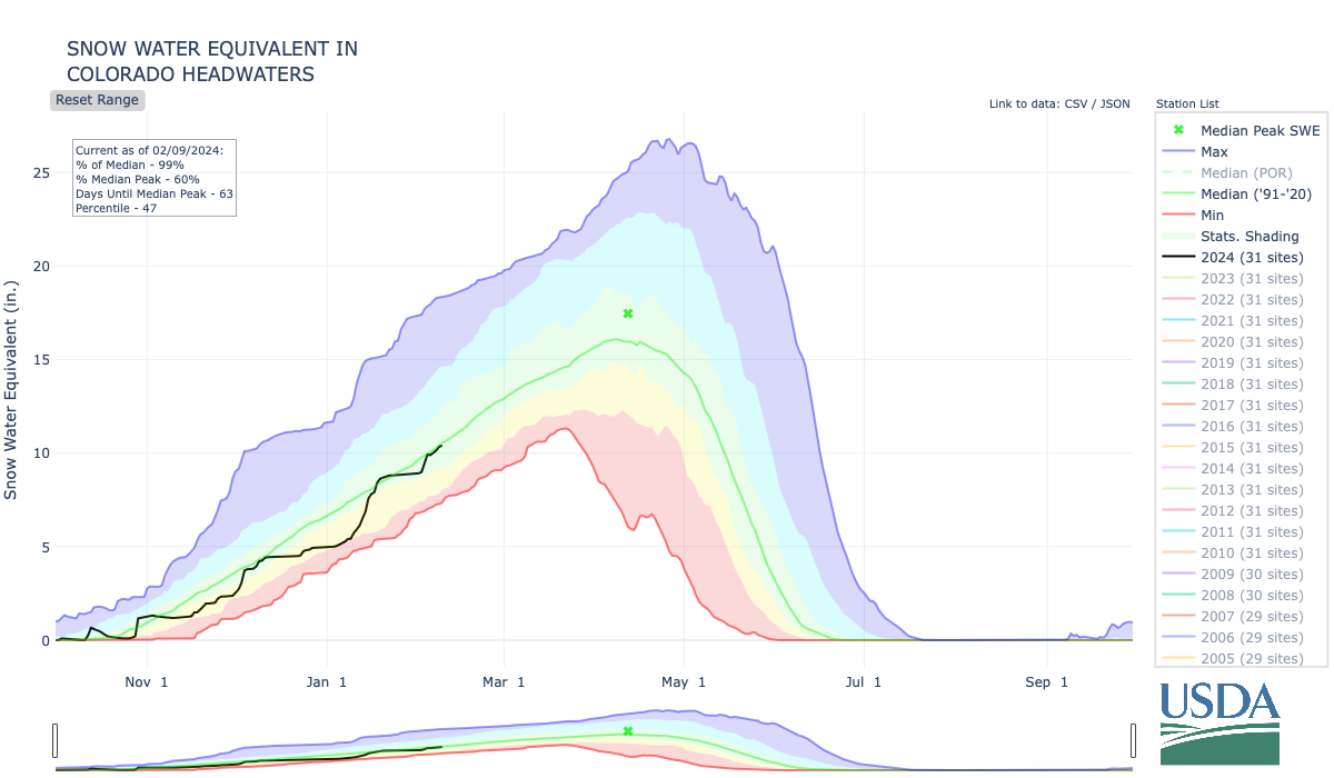
Colorado’s statewide snowpack is currently at 96% of the 30-year average, and storms in the forecast could push it closer to 100%. While a majority of the snow is slated to arrive early next week, experts are predicting snowfall varying from 1 to 3 inches for many of Colorado’s ski resorts over the course of the next couple days…[Jim] Kalina said a storm system moving in early next week is expected to bring favorable conditions to those looking to hit the ski slopes.
The Colorado Headwaters Basin — including the northern and central mountain regions as well as parts of the Western Slope — is currently at 97% of the 30-year median. In terms of whether or not it will push the Colorado Headwaters Basin up to 100% snowpack, Kalina said “It looks like a pretty good storm, so it could bump it up a little bit to be in that kind in of range.”
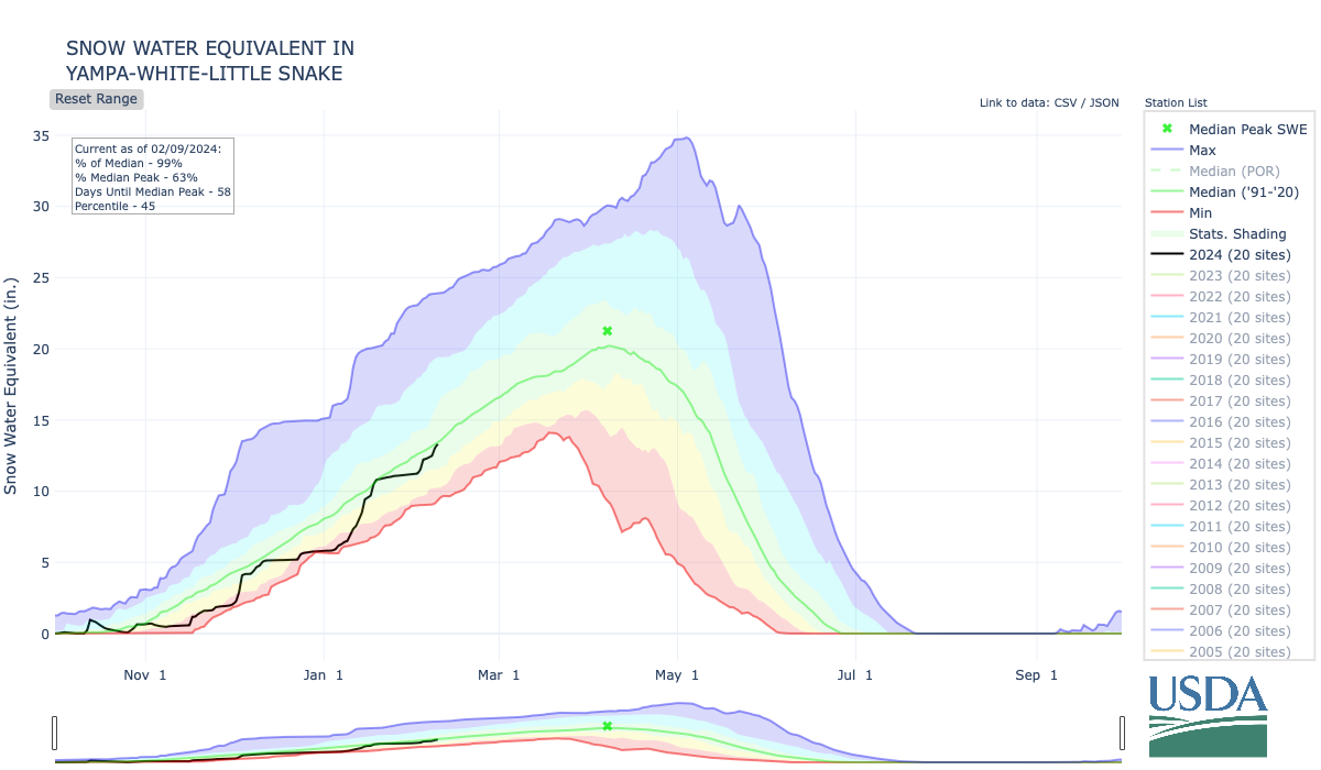
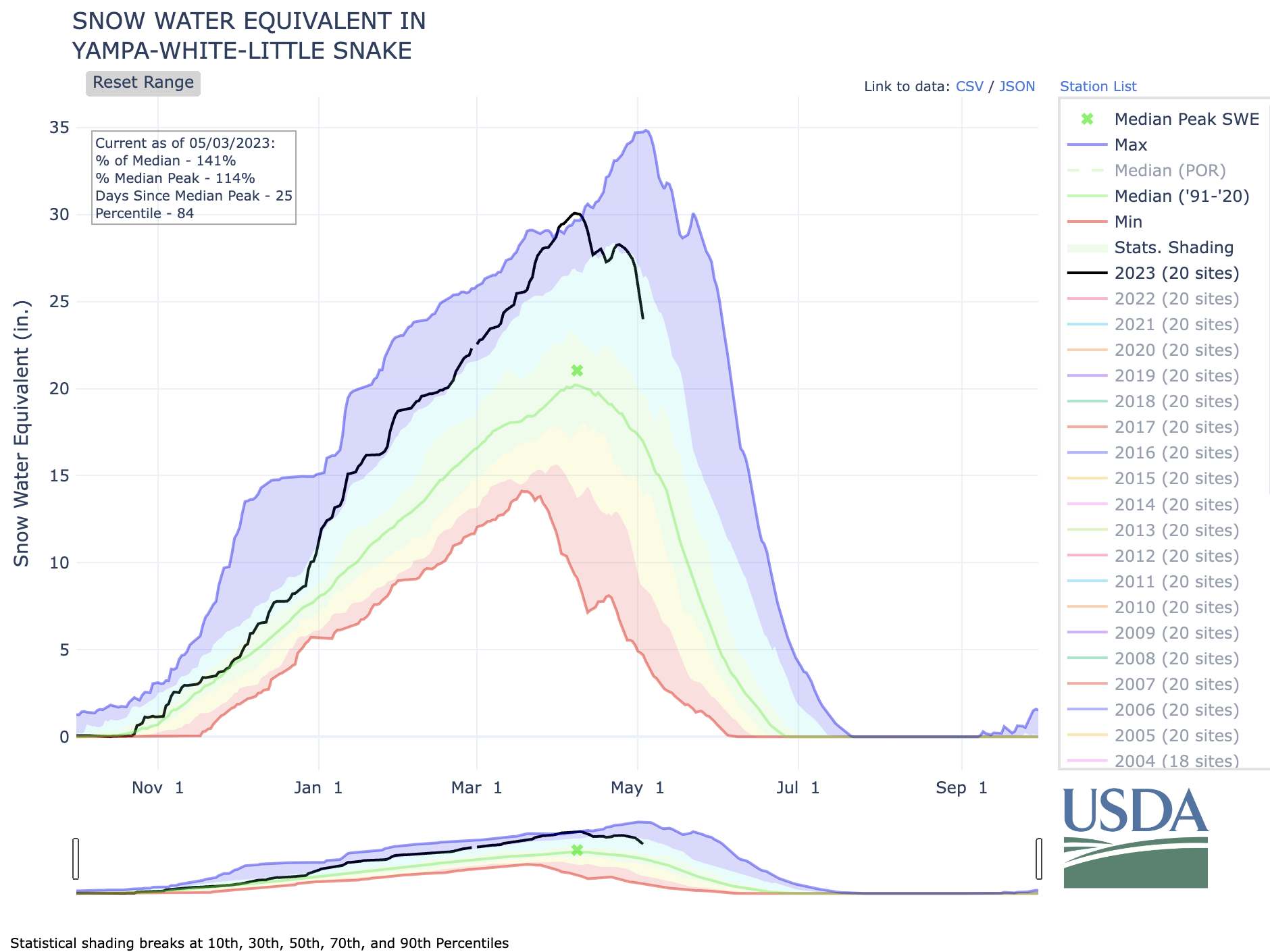
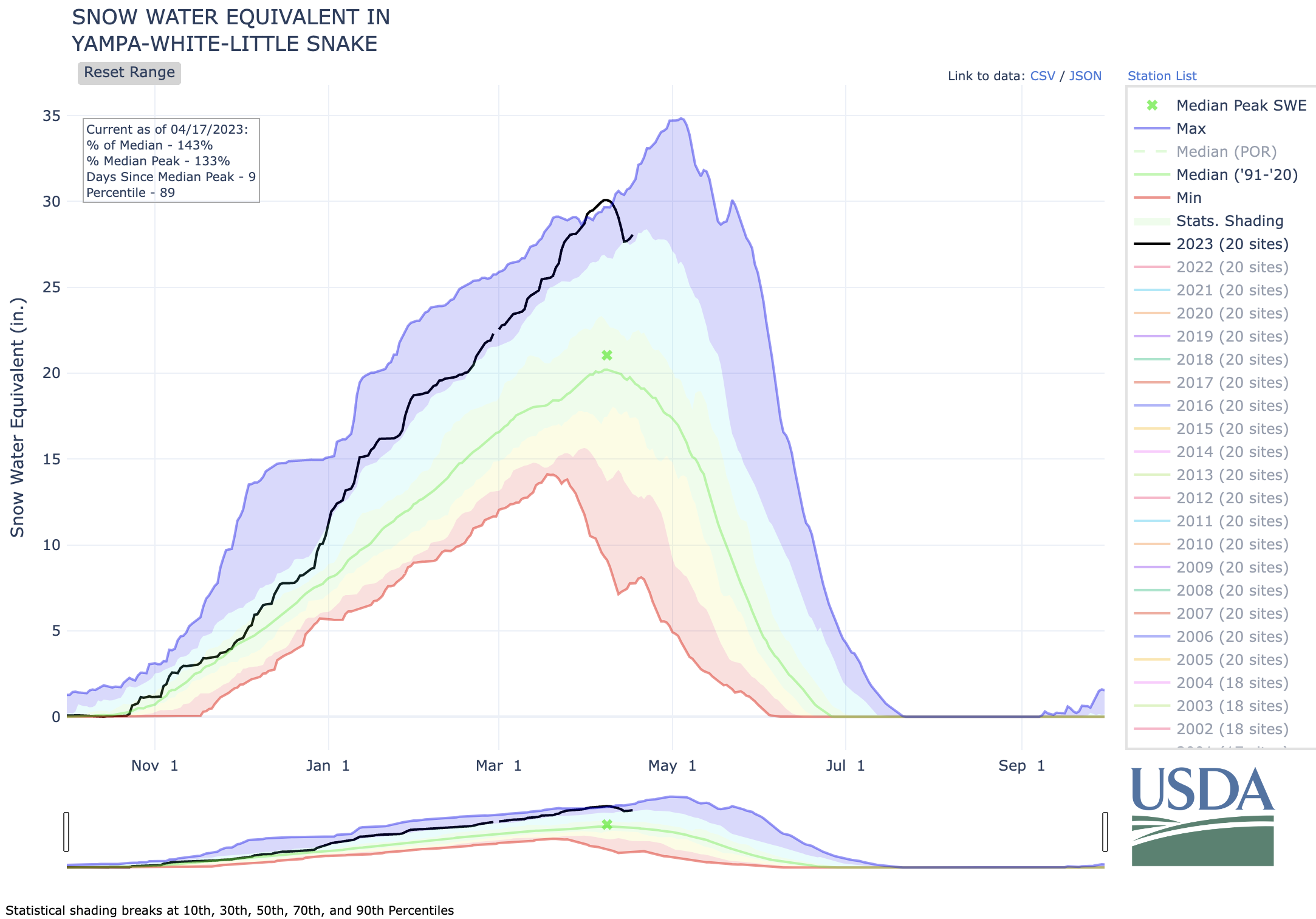
…the Yampa-White-Little Snake River Basin, which is currently at 105% of the 30-year median for snowpack…The USDA National Resources Conservation Service reported that The Colorado Headwaters Basin generally reaches its snowpack peak around April 12, and the Yampa-White-Little Snake River Basin generally reaches its snowpack peak around April 7.
As the Stewardship Manager for Colorado Water Trust, I am lucky to have several interesting jobs outside of developing new projects. I write a monthly forecasting memo that helps our staff plan for the upcoming season’s operations. I travel around the state and visit our projects to ensure they are still operating as designed. I collect streamflow and water temperature data to inform project design. It’s all great work but there is one job that is arguably the most important; I maintain and update (read the next words in an important sounding voice) The Master Dashboard Accounting Spreadsheet.
This spreadsheet tallies the streamflow volumes and the number of river miles with improved flows. Volume and miles restored are the primary metrics that describe our impact. We must report accurate records to the Division of Water Resources, and our funders like to see our volume and mileage metrics, as well. Heck, the first thing you see on our website is a cool animation tallying up our volumes and stream miles. Just looking at the site now, I see that we have restored 73,242 acre-feet of water to 612 miles of Colorado’s rivers, which is very impressive… or is it? Honestly what do those numbers mean? Is our work important? Impactful? Let’s dig a little deeper to find a better way to highlight the benefits our work.
Let’s start with terms. Acre-feet is a weird one—it’s a very important term in the water world but doesn’t translate well to a general audience. Us water nerds often try to better explain the term. “An acre-foot of water is enough water to supply two average households for one year” we will say in a very serious tone. Great, so now we can visualize how many showers and toilet flushes the Water Trust has restored. Hmm… perhaps if we convert it to gallons it will make more sense. I see that we have restored 22.6 billion gallons—that sounds impressive! Let’s convert it to metric tablespoons to get a truly enormous number. Unfortunately, the human brain is epically bad at comprehending large numbers so perhaps we should look at this another way.
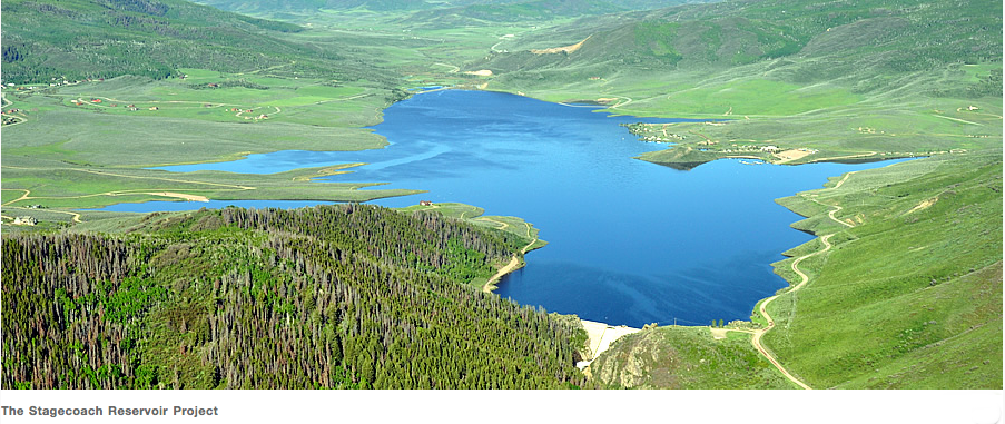
Rivers and streams are not simple units easily counted and categorized. Rivers are homes for fish, drinking water for towns, irrigation water for farmers, places of recreation, and focal points for communities in the arid west. Rivers are local and personal. Our Yampa River Project is a great example for examining the alternative metrics we can use to measure our impact on the river and the community that depends on it. Low summertime flows on the Yampa lead to high water temperatures that are unhealthy or even deadly to the trout who call the river home. To help protect the trout, Colorado Parks and Wildlife (CPW) is often forced to close the river to extremely popular recreational activities like angling and tubing. While the closures help keep fish alive, they severely impact summer tourism and the local economy. Since 2012, the Water Trust has partnered with the Upper Yampa Water Conservancy District, Colorado Water Conservation Board, City of Steamboat Springs, and the Yampa River Fund to release additional water from Stagecoach Reservoir 18 miles upstream of Steamboat. These releases help cool temperatures for the fish and keep the river open for recreation. Now, let’s take a closer look at some of the metrics that tell the story of our impacts to the Yampa and the Steamboat community.
Take a look at the plot below, which shows the flows in the Yampa River in Steamboat during the late summer of 2023. The blue shading shows the flows that the Water Trust released. Last summer, Water Resources Specialist, Blake Mamich, saw that dropping flows and high river temperatures were exceeding regulatory thresholds (which lead to river closures) so he acted quickly, coordinating releases to boost stream flows and keep the river cool.
Graphic credit: Colorado Water Trust
Let’s look at some of the metrics that help tell the story of this successful project. In 2023, the Yampa River Project:
Released water for 60 days, keeping the river cool to keep the city compliant with regulations.
Boosted flows for fish for nearly two months.
Averted 38 days of river closures, keeping the river open when it would have otherwise been closed for over a month during the busy tourism season.
Water Trust releases often accounted for over 30% of the entire flow in the Yampa River, and has accounted for over half of the flow in years past.
Now there are some metrics that show the impact of our work a little better than 3,288 acre-feet or one billion gallons. Let’s look beyond the flow numbers to see how the project is providing benefits to the upper Yampa community. A 2019 study by the Steamboat Chamber of Commerce found that summer tourism has a $166 million-dollar impact on the city which supports over 2,000 jobs. While I am not an economist, it’s not unrealistic to imagine that a 38-day closure of the river flowing through the heart of town would reduce those numbers. It’s also interesting to note that less than 2% of the economic benefits would easily pay for this project to run in perpetuity. Looking beyond the tourism impacts, the water continues to flow downstream of Steamboat where it is available to agricultural users along the length of the river. This project is also a long-term investment in sustainable river health as the Water Trust has operated this project in 10 of the last 12 years, providing a decade of benefits.
Digging more deeply into the impact of our projects really shows why our work is so important. They go beyond just putting flows into the river—they make tangible and long-term impacts on the habitats and communities that rely on healthy rivers across the state.
I will keep updating the Master Dashboard Accounting Spreadsheet and reporting our volume numbers since they are still very important to our work, but I promise to chime in here on occasion to highlight all of the benefits that our projects generate. So next year when you are reading the annual report and you see we have restored enough water to cover Manhattan Island to a depth of 5 feet*, know that there is a story behind the numbers.
*That is true by the way.
The Yampa River emerging from Cross Mountain Canyon in northwest Colorado had water in October 2020, but only the second “call” ever was issued on the river that year. Photo/Allen Best
A second atmospheric river of moisture in a matter of days is further bolstering Colorado snowpack levels that have continued to lag a bit behind normal…An initial atmospheric river storm system that wound down over the weekend dumped as much as three feet of snow in parts of the mountains, with the Colorado Avalanche Information Center saying the Ruby and Ragged ranges west of Crested Butte and south of Marble were particularly hard-hit. The Mesa Lakes area on Grand Mesa got about 15 inches of snow in that storm and Park Reservoir saw about a foot of snow fall, while another measuring site on Grand Mesa got only about 4 inches, said Dennis Phillips, a meteorologist for the National Weather Service in Grand Junction. The second atmospheric river that arrived this week is expected to be a stronger system, he said…
The federal Natural Resources Conservation Service on Tuesday said that statewide snowpack in Colorado stood at 93% of normal for Feb. 6. It has seen little growth since the middle of last month or so, after increasingly sharply from below 70% of normal at the start of January.
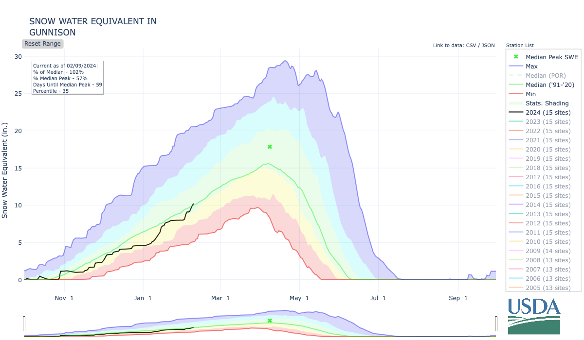
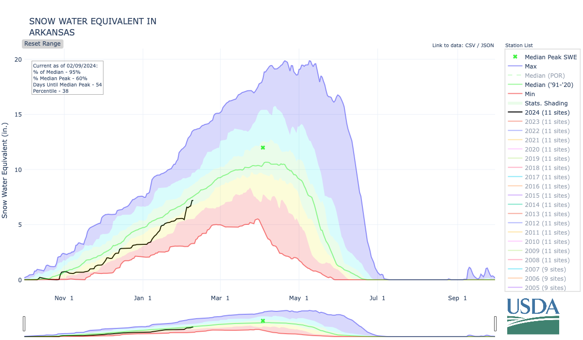
Snowpack in the Colorado headwaters basin on Tuesday stood at 96% of normal for Feb. 6. The Yampa-White-Little Snake basins were at 95% of normal, as was the Gunnison River Basin, and the Arkansas River Basin was at 91%.
Southwest Colorado is drier, with the combined San Miguel-Dolores-Animas-San Juan basins at 84% of normal and Upper Rio Grande River Basin at 80%. On Grand Mesa, snowpack levels at NRCS sites Tuesday ranged from 93% at Mesa Lakes to 74% at Overland Reservoir. Mountain snowpack is relied upon to bolster streamflows, reservoirs and agricultural and municipal supplies when that snow melts and runs off.
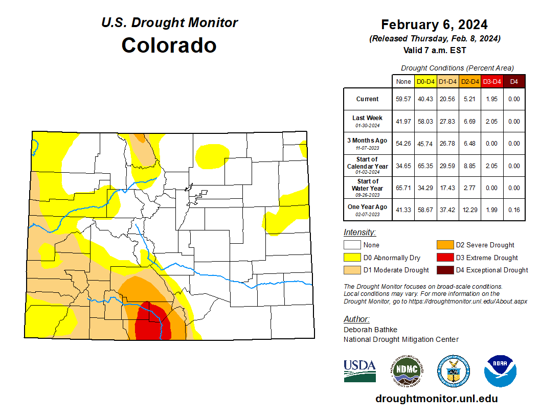
Colorado Drought Monitor map February 6, 2024.
Most of Southwest Colorado is in varying levels of drought, with moderate drought stretching into western and southern Mesa County, according to the U.S. Drought Monitor.
Wyoming’s plan to construct the West Fork Dam in the Medicine Bow National Forest “does not align well” with federal policy and management plans, a forest official wrote in a 2022 brief intended for U.S. Secretary of Agriculture Tom Vilsack.
The Medicine Bow environmental policy analyst who evaluated the state’s plan for the 264-foot high dam also said the proposal might not meet a U.S. Forest Service public-interest standard necessary for a land swap that would enable dam construction.
The critical assessment was penned as Medicine Bow staff prepared a briefing paper on Wyoming’s plan to construct the dam and its 130-acre reservoir in Carbon County to serve fewer than 100 irrigators who want more late-season water. Forest officials sought staffers’ input on the proposed development above the Little Snake River.
Medicine Bow officials were preparing the late-2022 briefing for regional and Washington D.C. officials, unnamed VIPs and Secretary Vilsack, according to documents obtained by WyoFile through a records request.
In an internal Medicine Bow email, forest environmental policy analyst Matt Schweich asked that the briefing paper state that “[t]he Forest is concerned that the State’s current preferred concept does not align well with Forest Service policy and the Forest plan, that it may not be in the public interest, and is likely to be highly controversial with the public.”
Ninety-six percent of comments on the plan opposed the project, a WyoFile tally of submissions showed. Criticism ranged from the project’s environmental impacts to Wyoming’s rosy analysis of public benefits and the state’s willingness to fund the bulk of the project for the benefit of private irrigators.
An ongoing environmental review necessary to advance the Wyoming project will determine whether the dam plan meets federal policies and the Medicine Bow management plan. A federal-state land exchange necessary for construction must be found to be in the public interest. An environmental impact statement and associated reviews of the proposal have been delayed once, and their completion date remains uncertain.
A Medicine Bow spokesman said Schweich’s opinion does not reflect the official position of the agency, which will only be revealed through the environmental impact statement.
Last puzzle piece
The Forest Service, U.S. Natural Resources Conservation Service and U.S. Army Corps of Engineers are working to complete the EIS in a process largely obscured from public view. The emails, however, provide another peek into the thinking of Forest Service specialists regarding the merits of the controversial project.
In another internal discussion previously reported by WyoFile, a Medicine Bow hydrologist expressed worry that the dam proposal wasn’t being thoroughly vetted. Medicine Bow spokesman Aaron Voos dismissed that worry last year, characterizing the criticism as healthy agency discussion.
Schweich added his newly revealed assessment of the dam plan in a Sept. 26, 2022 email exchange as Medicine Bow staffers were preparing a “Hot topic” report for leadership, including Vilsack. Fully four years before that, Wyoming water developers had settled on the size of the dam, the capacity and size of the reservoir and the site of the complex. Wyoming has not deviated significantly from those plans.
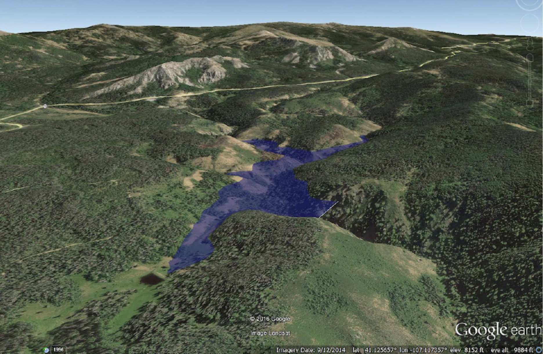
Little Snake River watershed S. of Rawlins. Water developers want to construct an $80 million, 264-foot-high dam on the West Fork of Battle Creek south of Rawlins. This artist’s conception shows what the reservoir would look like in a Google Earth rendition. Credit: Wyoming Water Development Office.
A month before Schweich wrote his 2022 assessment, Wyoming had provided the last piece of the puzzle, telling Medicine Bow officials the state would seek 1,762 acres of forest land in an exchange that would enable construction of the dam and reservoir. Jenifer Scoggin, director of the Wyoming Office of State Lands and Investments, provided that land-swap information to Medicine Bow officials in August 2022,according to a letter she wrote later that year.
Medicine Bow officials appeared to have known the size of the dam and reservoir, their location and the federal acreage Wyoming sought when the officials asked Schweich for his assessment.
A month after Schweich responded, Wyoming submitted its formal proposal to the Medicine Bow for a land exchange and dam construction.
Regardless how well-informed Schweich was when he made his 2022 assessment, spokesman Voos said it was unclear at that time exactly what the state intended.
“[T]he internal, draft email of Hot Topics updates [to which Schweich contributed] is prior to receipt of any formal land exchange proposal from the State,” Voos wrote WyoFile. “At the time, multiple informal discussions were taking place surrounding conceptual ideas.
“Since it was unclear what the State’s future use of any current National Forest System land might have been at that time,” Voos wrote, “then yes, there was the possibility for misalignment with our policy and Plan.”
WyoFile obtained the emails through a Freedom of Information Act request. Although the environmental impact statement is being written largely out of public view, the public had an opportunity to weigh in on the issue before the analysis began. People will be able to comment on the review when it is completed.
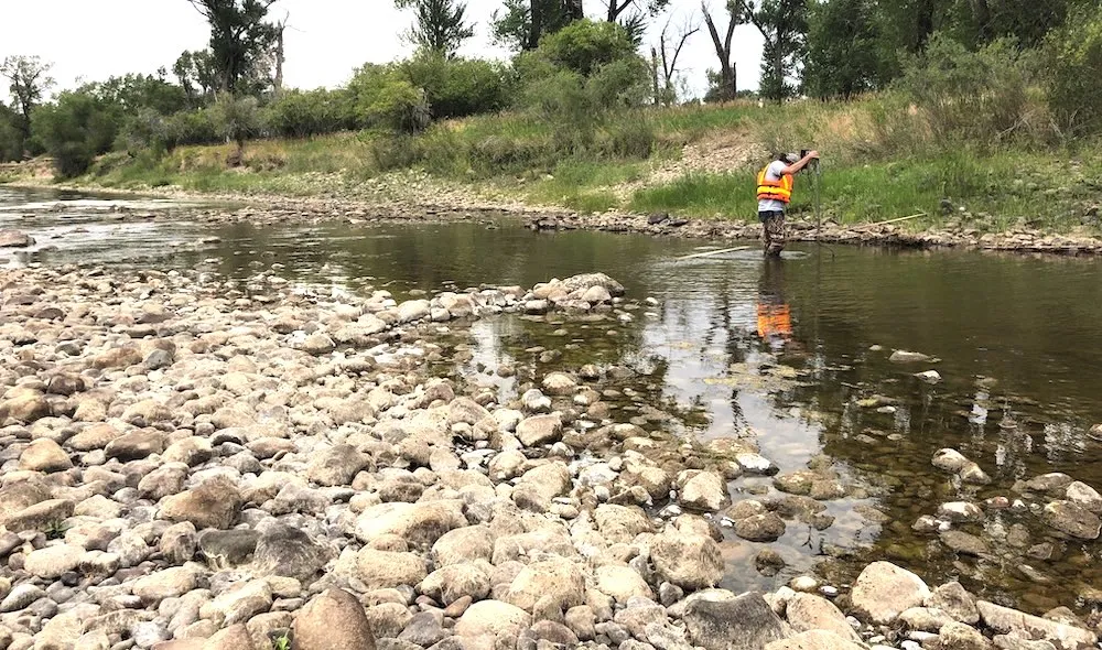
Scott Hummer, former water commissioner for District 58 in the Yampa River basin, checks out a Parshall flume installed on an irrigation ditch in this August 2020 photo. CREDIT: HEATHER SACKETT/ASPEN JOURNALISM
From email from the Colorado Division of Water Resources (Michael Elizabeth Sakas):
January 26, 2024
The Colorado Division of Water Resources announced that as of January 16, 2024, new rules governing the measurement of surface and groundwater diversions and storage are now in effect for Division 6. The division includes the Yampa, White, Green and North Platte River basins.
“The Division 6 Measurement Rules are the first set of rules covering surface water measurement in the State of Colorado and are a significant milestone for the Division of Water Resources,” said Erin Light, Division 6 Engineer. “The adoption of the rules will provide the Division of Water Resources greater leverage in assuring that the diversion and use of water is administerable and properly measured and recorded.”
For background, Colorado statutes include a requirement that owners of ditches and reservoirs install headgates where water is taken from the natural stream. These statutes also give the state and division engineer the authority to require owners and users of water rights to install measuring devices.
“Accurate measurement of diversions is critical to protect Colorado’s entitlement to water, including under the Colorado River Compact, and to ensure we are maximizing the beneficial use of the public’s water resource for consumptive and environmental purposes,” said Jason Ullmann, Deputy State Engineer.
The statutes, however, do not include any specifics regarding what is considered an acceptable headgate or measuring device. Historically, it has been administered by the Division of Water Resources (DWR) through issuing orders to owners for the installation of headgates or measuring devices.
“Over several years, Division 6 has issued hundreds of orders for the installation of operable headgates and measuring devices with varying degrees of success,” said Division Engineer Light. “I believe that these rules will help water users in Division 6 by providing clarity regarding what structures require measurement and what is considered an acceptable level of accuracy for the required measurement methods.”
The rules describe two types of measurement methods: measuring devices, which are physical devices (flumes, weirs, etc) that are placed in a diversion for measurement. Then there are alternative measurement methods, which are typically indirect methods of measuring flow rates without a physical device.
Water users are provided the following time periods to comply with the rules:
Diversion structures with a capacity or water rights greater than or equal to 5.0 cfs – 12 months (January 16, 2025);
Diversion structures with a capacity or water rights greater than or equal to 2.0 cfs and less than 5.0 cfs – 18 months (July 16, 2025);
Diversion structures with a capacity or water rights less than 2.0 cfs – 24 months (January 16, 2026);
Reservoirs with a capacity or water rights greater than or equal to 5.0 AF – 12 months (January 16, 2025);
Reservoirs with a capacity or water rights less than 5.0 AF – 24 months (January 16 2026).
Water users unsure of their decreed water right or permitted well permit flow rates and volumes can use DWR’s online tools available through CDSS (https://dwr.state.co.us/Tools/) to find this information. Anyone who has questions regarding how these Rules apply to their diversion or how to install a measuring device on their system can contact the DWR’s Division 6 Lead Hydrographer at (970) 291-6551. The Rules are available on the DWR website as a Laserfiche imaged document.
Yampa River Basin via Wikimedia.
Map of the North Platte River drainage basin, a tributary of the Platte River, in the central US. Made using USGS National Map and NASA SRTM data. By Shannon1 – Own work, CC BY-SA 4.0, https://commons.wikimedia.org/w/index.php?curid=79266632
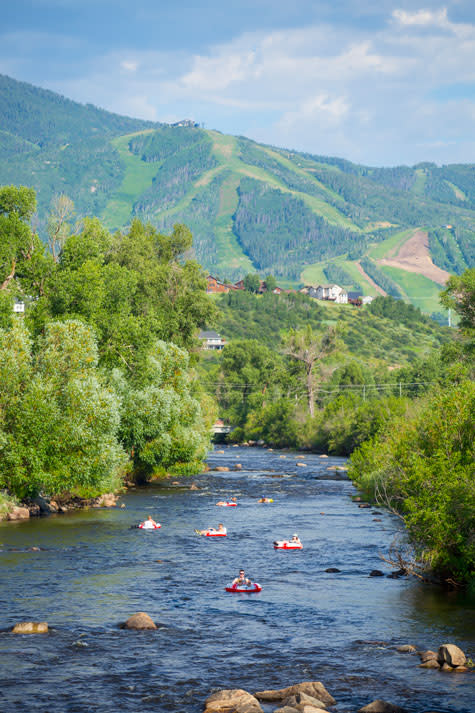
Tubing the Yampa River in Steamboat Springs. Tubing season typically begins in June and lasts through August. Conditions are reliant on the amount of snow-melt and rainfall Steamboat receives. If the water levels are too high or too low tubing will be halted. Photo credit: City of Steamboat Springs
A new forecasting tool to determine closing and opening procedures for the Yampa River is among a set of proposed regulations being discussed by city officials. The proposed policies are aimed at protecting “the biological integrity of the Yampa River while sustainably managing recreation,” according to a report provided to council members last week. Late last year, Parks and Recreation commission members approved the use of the new tool, provided by the Carbondale-based firm Lotic Hydrological, which will set closure and reopening decisions for the Yampa River based on a framework of scientific criteria. Craig Robinson, Parks and Recreation Open Space and Trails Manager, said the current regulations for the criteria to determine river openings and closures “are a little bit vague,” in that they are based on a number of factors and involve consultation with Colorado Parks and Wildlife…
Outfitters and anglers licensed by the city to use the Yampa River agree the health of the river’s ecosystem is most important, but depending on their interests, they don’t necessarily agree over the proposed policies. Backdoor Sports owner Pete Van De Carr noted the proposed system to close and reopen the river will likely result in less frequent but longer-term closures…
Brett Lee, the owner of Straightline Sports, provides angling tours for his customers on the Yampa River. Unlike Van De Carr, he said he welcomes the new opening and closing procedures being pitched by city staff because they will, hopefully, help mitigate the impact of tubing on the river…Adding to system for determining the opening and closing of the Yampa River, the city is also proposing new policies for licensed commercial outfitters that supply tubes and other guided services on the Yampa River. The proposed rules will require any tubes rented by outfitters or sold in the city must have a minimum 30-guage PVC thickness. If approved, they would also implement a three-year permit renewal process for outfitters and will specify that tube allocations for the outfitters are not considered as “real or personal property.” Additionally, if any business owner with tube allocations sells their business — and its tubing allocations — the city must be notified, and the new entity must reapply to assume their allocation.
Early morning fog hangs in the valleys above this irrigated field outside of Kremmling in July 2021. The pasture is part of a study that aims to learn about the impacts of using less water on high-elevation fields. CREDIT: HEATHER SACKETT/ASPEN JOURNALISM
The results of a recent economic study of Grand County irrigators show that certain water conservation programs may be worth it for irrigators who grow hay but not for those who grow cows.
In 2020, a group of nine flood irrigators in the Kremmling area, scientists and conservation groups began a multiyear research project to find out what happens when irrigation water is withheld from high-elevation fields for a full season and a half-season. The project, officially called “Evaluating Conserved Consumptive Use in the Upper Colorado,” is ongoing through 2023, but preliminary results from 2020-22 show that the effects of taking water off a field linger beyond one season and that these types of programs may not make financial sense for irrigators who raise livestock.
In 2020, control fields were irrigated normally; some fields received no irrigation water and some received irrigation water only through June 15. Normal irrigation practices were resumed in 2021, 2022 and 2023. But the fields with no or less water in 2020 did not fully bounce back and produce the same crop yield as the control fields in subsequent years. The amount of water used by the plants, known as consumptive use, as well as the amount of forage crop production, lagged behind the control fields even two years after resuming normal irrigation, something maybe partly due to the extreme drought in the summers of 2020 and 2021.
Perry Cabot, a researcher with Colorado State University, and Hannah Holm, associate director for policy with environmental group American Rivers, worked on the project and presented their findings to the Colorado Basin Roundtable last month.
“2020 was such an awful, horrible drought year, especially late in the season,” Holm said. “We are wondering if the fact that there was basically no precipitation falling from the sky, and that summer of 2021 [was also dry], might have knocked back the treatment fields that much harder. … We do see substantial recovery when returned to full irrigation, but it’s not uniform across the fields and it seems to not be 100% a couple of years later.”
Where water was removed for half of the irrigation season, irrigators received $281 per acre, and those with full irrigation withdrawal received $621 per acre in 2020.
The study was funded by the Colorado Water Conservation Board, with support from the Colorado Basin Roundtable, The Nature Conservancy, Trout Unlimited and American Rivers.
The 2020 Economics and Enterprise Budgeting Report, released in August as part of the preliminary project report, found that these amounts need to be increased for irrigators who also raise livestock to make participation in the program worth it for them. The report, which is based on interviews, financial data and budgets from six of the participating irrigators, said agricultural producers who relied on their hayfields to feed cattle experience a net loss of profit, despite the payments.
Producers with livestock would have needed an average payment of at least $971 per acre to fully compensate them for the additional costs of not irrigating their fields. This was mostly due to the high cost of having to buy hay in a drought year to replace the hay they didn’t grow.
Those just growing hay saw an average of a $197 increase in income per acre on the full-season treatment fields; those growing hay saw an average $46 loss per acre on the half-season treatment fields. Those who also had a herd of cows to manage in addition to growing hay lost an average of $350 of income per acre on the treatment fields.
Paul Bruchez, a Kremmling rancher and CWCB member, is one of the project’s leaders.
“We were part of creating a deficit in our local hay market,” he said. “That was compounded by what was a natural drought. And then the end result was that hay was off-the-charts expensive.”
Many ranchers continue irrigating late into the season after their last cutting of hay so that they can grow back a little bit of grass, alfalfa or other forage crop on which their cattle can graze for several weeks in the fall before they start feeding them hay. Ranchers who participated in the project also lost this bit of fall grazing because they didn’t irrigate.
“They had a loss of production initially for the harvesting of the hay to feed them through the winter, but then they also lost fall grazing,” said Jenny Beiermann, an agriculture and business management specialist with Colorado State University, who co-authored the economics study. “They incurred a lot of additional expenses compared to those who were just harvesting hay, and that’s why they needed a higher rate of payment for their fields.”
These cows live on the Fetcher ranch in Clark, north of Steamboat Springs. The results of a recent economics study found that certain types of water conservation programs may be worth it for irrigators who grow hay, but not for those who raise livestock.
CREDIT: HEATHER SACKETT/ASPEN JOURNALISM
System conservation
These findings could have basinwide implications for the Upper Colorado River Commission’s System Conservation Program, which in September water managers voted to continue in 2024. The federally funded program pays irrigators to forgo watering their fields for a season with the goal of protecting critical elevations in the nation’s two largest reservoirs, Lake Powell and Lake Mead. The 2024 program will have a narrower scope that explores demand-management concepts and supports innovation and local drought resiliency on a longer-term basis.
For the 2023 System Conservation Program, water managers set the opening payment to producers at $150 per acre-foot conserved, a number that some producers told Aspen Journalism was insultingly low. Producers could then negotiate up from there. SCP project participants in Colorado were paid an average of about $394 for every acre-foot conserved. The average price per acre-foot across the four upper basin states — Colorado, Utah, Wyoming and New Mexico — was $422.
For 2024, the program will offer Colorado irrigators a fixed price of $509 per acre-foot conserved.
UCRC Executive Director Chuck Cullom said the agency used projected commodity prices and crop budgets from CSU to arrive at the amount of compensation offered to producers for 2024 and did not take into account whether an irrigator had a cow/calf operation.
Another thing the project is studying is how birds use irrigated agricultural lands. But the results through 2022 of an avian monitoring project by Audubon Rockies were inconclusive. Researchers expected that when irrigation was resumed in the years after 2020, there would be more water-associated birds. The number of bird species counted did increase in 2021 — the first year irrigation water returned — but not in 2022.
“In some regard, the results from 2022 were diminished from those in 2020 (treatment year), which further opposed our expectations,” the report reads. “Birds are highly diverse, mobile creatures that use a wide array of habitats for many different seasonal purposes, often making it challenging to interpret the outcomes of avian monitoring efforts.”
The thing to keep in mind about the economics study, Beiermann said, is that it was small and that conditions in high-elevation Grand County can be particularly brutal, with long winters. Drought and water availability can vary widely across the upper Colorado River basin and from year to year. Still, a key takeaway is that these types of water conservation programs may be better suited for irrigators who grow only hay.
“Agriculture is a really risky business and being profitable is really tough,” she said. “There are too many variables (for livestock producers). Generally speaking, they are going to have a lot higher costs.”
Residents and river lovers may have noticed weeks of river cleanup and streambank restoration work that took place this fall along the Yampa River in south Steamboat Springs at the site of a former concrete batch plant of decades past. For about five weeks this fall, workers removed dozens of dump truck loads of concrete, rebar, debris and an old concrete truck, said Mitch Clark, owner of Snow County Nursery, who purchased the 10-acre site located off Dougherty Road just south of the current southern end of the Yampa River Core Trail. Heavy machinery could be seen in the river this fall moving huge boulders…
Clark purchased the land on either side of the Yampa River adjacent to his existing nursery, garden center and landscape company. The business owner received a floodplain development permit to clean up the river bank, stabilize the bank, prevent erosion, increase sediment transport and provide habitat, according to Alan Goldich with Routt County Planning. The river work was designed by Landmark Consultants in Steamboat..
“The floodplain permit does allow for that type of activity, and he did receive an Army Corps permit as well,” Goldich noted.
Clark received significant grant support for the restoration project through the USDA Natural Resources Conservation Services EQIP program, or Environmental Quality Incentives Program, which provides financial and technical assistance to agricultural producers, said Vance Fulton, NRCS engineering tech in Steamboat…Fulton said the Yampa River through the property was too wide and too shallow, so material was being deposited in that section of the river during high water runoff in the spring.
“New plot using the nClimGrid data, which is a better source than PRISM for long-term trends. Of course, the combined reservoir contents increase from last year, but the increase is less than 2011 and looks puny compared to the ‘hole’ in the reservoirs. The blue Loess lines subtly change. Last year those lines ended pointing downwards. This year they end flat-ish. 2023 temps were still above the 20th century average, although close. Another interesting aspect is that the 20C Mean and 21C Mean lines on the individual plots really don’t change much. Finally, the 2023 Natural Flows are almost exactly equal to 2019. (17.678 maf vs 17.672 maf). For all the hoopla about how this was record-setting year, the fact is that this year was significantly less than 2011 (20.159 maf) and no different than 2019” — Brad Udall
Colorado could spend millions more to replace water-hungry lawns, keep extra water in streams to protect fish and their habitats, and repair water-wasting farm and city delivery systems, according to a list of potential fixes from a state task force hoping to drought-proof the Colorado River.
The 17-member panel finished its preliminary list of recommendations [December 1, 2023]. It will finalize the list Thursday and hone it for a final report to lawmakers due December 15, 2023.
The task force’s job has been to identify new policies and tools to help save water and ensure neither Colorado water users nor the environment are adversely affected by any new federal Colorado River agreements designed to protect the drought-strapped river across the seven-state region where it flows.
Created by lawmakers last spring when they approved Senate Bill 23-295, the task force includes representatives of environmental and agricultural groups, urban and rural water users, and the Southern Ute and Ute Mountain Ute tribes, among others.
In all, 24 recommendations will be voted on this week, covering a broad range of options, including small storage projects, more flexibility in sharing water stored in reservoirs, and new tools to measure water so that conservation programs can operate effectively.
“It has been a very short timeline, but it has been concentrated time,” task force chair Kathy Chandler-Henry said. “People showed up every other week in far-flung places for five-hour meetings and we have worked well together. It has felt as if it was a common goal to do something positive for drought in Colorado and get something useful to the legislature.”
The recommendations could make their way to lawmakers next year, or could be addressed by water agencies if no legislation is required to make the changes.
Among the proposals is a request to dramatically boost funding for a new state program that gives cities, water districts and nonprofits cash to help residents and businesses tear out thirsty lawns and replace them with water-saving landscapes. Last year, lawmakers provided $2 million for the work, including $1.5 million in actual grants. But some task force members would like to see that number rise significantly, perhaps as high as $5 million, according to Randi Kim, utilities director for the City of Grand Junction. Nevada spends $24 million on such programs, according to the task force.
“The current levels are helpful,” Kim said. “We received a $25,000 grant and we can do about 50 single-family homes. More money would have a broader effect.”
Also on the list are several proposals that would bolster tools used to keep water in streams, including a state program that allows water to be loaned to a stream for a certain period of time. Under one task force recommendation, the loan program could be operated for longer periods of time.
In another proposal, Tri-State Generation and Transmission Association is asking that water rights it controls, which are used to help run its coal plants in the Yampa River Valley, be preserved once the plants are shut down, a process that is scheduled to occur between 2025 and 2028. The recommendation isn’t specific only to Tri-State, but could include other utilities with coal-fired power plants and creates a pilot program in the Yampa Valley.
Under Colorado law, the rights to water that is no longer used must be transferred or sold to another user or the water must be returned to the river. Traditionally, the idea has been to prevent water right holders from hoarding water they are not using. But the utility is asking that its water rights be protected and left in the river even if they are not being used through 2050, in case they are needed for future green power projects.
Such proposals have won the support of environmental groups, including Conservation Colorado, which maintain that finding ways to leave additional water in streams offers more protection for the environment, and the communities and recreation economies that rely on the waterways.
“The Western Slope in particular has been threatened by drought, by river closures due to low flows, and fish kills due to low flows. These measures could help Colorado become more resilient,” said Josh Kuhn, senior water campaign manager for Conservation Colorado.
There also are recommendations to provide more funding to improve leaky water systems for irrigators and cities. Though water funding has increased from some sources, such as tax revenue from sports betting in Colorado and from the federal government, task force members said funding is still difficult to come by and needs to be prioritized.
Steve Wolff, a task force member representing the Southwestern Water Conservation District in Durango, said it’s unclear how many of the recommendations will turn into on-the-ground drought fixes.
“I certainly think it’s been a good discussion,” Wolff said. “But a lot of these things involve more funding. We need to understand if by doing these things, are we taking money from elsewhere and is that fair? I think it would be helpful to start prioritizing, whether it should be for aging infrastructure, or more storage, or other things.”
More by Jerd SmithJerd Smith is editor of Fresh Water News. She can be reached at 720-398-6474, via email at jerd@wateredco.org or @jerd_smith.
This photo shows the newly-installed headgate stem wall at the Sheriff Reservoir dam in Routt County. The town is moving forward with repairs to the dam’s spillway after the Colorado Division of Water Resources placed restrictions on the 68-year-old structure in 2021.
Town of Oak Creek/Courtesy photo
Oak Creek is preparing to move forward with important upgrades to a 68-year-old dam at Sheriff Reservoir…With the threat of a dam breach, the town worked with the engineering firm W. W. Wheeler & Associates to create a hydrology study to determine what repairs would be necessary. Completed this year, the report used updated high elevation hydrology formulas to anticipate how much water the dam and its spillway would need to handle in a maximum flood event. According to Torgler, the study found the spillway would need to be expanded from its current 32 feet to 55 feet across. Approved by the state’s engineer Monday, the study is key, the town administrator said, because it was originally believed the expansion improvement would need to be 330 feet across…
After completing work to replace the headgate on the dam, which sits close to the structures base on the reservoir side, the project will now turn to the completion of the design engineering for the spillway enhancements, Torgler said. To date, the town has spent $520,000 for design engineering for the headgate and the purchase and installation of operating equipment and $320,000 for final design work. Cost estimates for the spillway work will be ready by the end of the year.
Torgler said that without performing the dam improvements, there would be a significant reduction in the amount of water stored in the reservoir. He noted the reservoir provides recreational opportunities for locals and visitors, but it is also Oak Creek’s drinking water supply.
Eagle River Water & Sanitation District General Manager Siri Roman. Photo credit: Allen Best/Big Pivots
Click the link to read the article on the Big Pivots website (Allen Best):
The Western Slope delivers 70% of the Colorado River water. So why do Aspen, Vail and other places want to replace thirsty turf?
This story, a collaboration of Big Pivots and Aspen Journalism, is part of a series that examines the intersection of water and urban landscapes in Colorado.
If you’ve ever slipped and spun your way across Vail Pass through a wet, heavy snowstorm, you can be excused for wondering how Eagle River Valley communities could ever have too little water.
Vail and its neighbors do have that problem, though. It has become evident in the growing frequency of drought years in the 21st century.
U.S. Drought Monitor July 23, 2002.
First came 2002. Water officials, verging on panic, restricted outdoor water use. The drought was believed to be the most severe in 500 years. Fine, thought water officials as rain and snow resumed, we’re off the hook for at least our lifetimes.
West Drought Monitor map October 12, 2021.
In 2012 came another drought, one nearly identical in severity. More bad years followed in 2018 and 2021. The Eagle River normally chatters its way down the valley through Avon and to a confluence with the Colorado River near Glenwood Canyon. In those bad, bad drought years, it sulked. The shallow water was hot enough to endanger fish.
“New plot using the nClimGrid data, which is a better source than PRISM for long-term trends. Of course, the combined reservoir contents increase from last year, but the increase is less than 2011 and looks puny compared to the ‘hole’ in the reservoirs. The blue Loess lines subtly change. Last year those lines ended pointing downwards. This year they end flat-ish. 2023 temps were still above the 20th century average, although close. Another interesting aspect is that the 20C Mean and 21C Mean lines on the individual plots really don’t change much. Finally, the 2023 Natural Flows are almost exactly equal to 2019. (17.678 maf vs 17.672 maf). For all the hoopla about how this was record-setting year, the fact is that this year was significantly less than 2011 (20.159 maf) and no different than 2019” — Brad Udall
Colorado River flows have declined 20% since 2000. Having water rights is not enough. And the future looks even hotter and, because of that heat, drier. Brad Udall, a senior scientist and scholar at Colorado State University, warns of up to 20% additional flow loss by midcentury.
Average temperatures in the Colorado River Basin are projected by the U.S. Bureau of Reclamation to rise 5 to 6 degrees Fahrenheit during the 21st century. The agency projects slightly greater increases in Colorado and other upper basin states.
Average temperatures in the Colorado River Basin are projected significantly, even in headwaters areas such as in Glewnood Springs, where this photo was taken after a rainstorm in September 2023. Photo/Allen Best Top photo: Siri Roman of Eagle River Water and Sanitation District. Courtesy photo.
In Vail, managers of the Eagle River Water and Sanitation District have decided they need more storage. They plan a 1,200-acre-foot reservoir near Minturn called Bolts Lake. That compares with the 257,034-acre-foot storage of Dillon Reservoir. At that capacity, this new reservoir will be the most cost-effective way to ensure resilience as the climate becomes more variable. With the reservoir, they hope to capture water during high-runoff years for use in the district’s service territory from Vail through Edwards.
Demand reduction will be another tool of growing importance in a hotter, sometimes drier climate. Managers hope to reduce water demand in the district 5% by 2026 even as new housing, especially more affordable units, gets built. That’s 400 acre-feet per year.
The most productive place to wring these savings will be in water used for outdoor landscapes. Only 25% — or even less — of water applied to lawns returns to streams and rivers compared with 95% of water used indoors.
Siri Roman, the district’s general manager, said short-term change, such as restricted lawn watering in drought years, can be a strategy. But her district wants to effect permanent change.
“It’s not about drought years,” she said. “It’s about a drying climate. We have to get people to shift their attitudes, to know that water is getting to be more scarce.”
Roman’s district, like other water utilities in Colorado, is targeting nonfunctional turf. Precise definitions vary, but nonfunctional generally refers to grasses that require large volumes of water to irrigate but rarely see human feet except when mowed. It is also described as aesthetic turf.
Three years ago, Eagle River Water began offering rebates of $1 per square foot to customers willing to replace thirsty lawns with landscapes that use less water. Using state aid, the district this year bumped up the incentive to $2.
“We are not saying it needs to be stone and look like Arizona,” Roman said.
Directors of the district in October also agreed to new tiered rates that will discourage high-volume consumption.
Other Western Slope communities have also set out to discourage thirsty landscape choices. Motivations vary, but for many, there is also acknowledgement of the need to walk the talk of water conservation expected of Front Range communities. “That is something I hear a lot from communities I am working with,” said Marjo Curgus, a consultant.
‘Lawn Begone’ in Durango
Almost a decade ago, Steve Harris, a water engineer in Durango, summoned the local news media to his house to watch him remove sod from his front yard. He also had bumper stickers produced: “Lawn Gone.” In an editorial, the Durango Herald offered an alternative: “Lawn Begone.”
Harris believed that Colorado needed to make clear that decorative lawns had less value than agriculture. He worked with his state legislators to draft a bill that would have limited transfers of agricultural water to cities if that water went to lawns. As for his own lawn, Harris thought that he and others on the Western Slope couldn’t just pay lip service to this idea.
At the Colorado Capitol, the bill introduced in 2014 by then-Sen. Ellen Roberts and then-Rep. Don Coram was quickly shelved. Local governments objected. So did ag producers who thought state legislators had no business blocking their abilities to sell water rights.
Instead, the idea was directed to an interim committee for further study. Bills sometimes get sent there to die. In this case, the conversation continued, as Roberts had intended.
Since then, legislators have adopted several laws. A bill that passed in 2022, House Bill 22-1151, does not institute a prohibition but instead allocated $2 million to the Colorado Water Conservation Board, $1.5 million of which went to local jurisdictions to spur voluntary replacement of irrigated turf.
The law asserts that for every 100 acres of turf converted to water-wise landscaping, up to 200 acre-feet of water can be conserved. The act defines water-wise landscaping as a water- and plant-management practice that emphasizes using plants with lower water needs.
Whether that much water gets saved also depends upon whether irrigation systems are changed to match the lesser water needs of the new landscapes. Grass that needs 12 inches of supplemental water per year need not continue to get 25.
All that funding has now been allocated. On the Western Slope, the municipalities of Cortez, Glenwood Springs and Frisco were awarded funds as was the Eagle County Conservation District. The state agency said 25% of turf-replacement funds were for Western Slope entities.
Rep. Marc Catlin of Montrose and then-Rep. Dylan Roberts of Frisco, two of the four prime sponsors, are from the Western Slope. Another prime sponsor, Sen. Cleave Simpson of Alamosa, now has a district that encompasses southwest Colorado, while Roberts has become a senator.
Without state funding, Montrose County approved grants for seven turf-replacement projects.
“From the start, I thought this initial effort might have more value from an education and outreach perspective than actual water savings,” said Justin Musser, the county’s natural resources manager.
Projects were chosen based on various objectives. For example, do the new landscapes provide energy savings or wildlife benefits? “We are not overly prescriptive,” said Musser. “If you have a good plan that references standards from the Colorado State University Extension or another reputable source, the application gets a higher ranking.”
Why would Montrose County be interested in yanking sod to save water?
“It’s important that we look at these types of things across the Colorado River basin,” Musser said. “We would want people in California and Arizona and Nevada to be looking at these types of programs, too. I think it makes sense for a place like Montrose County to be conserving water as much as we can, too.”
But, he added, this is “one part of a very complex issue.”
As this diagram (Snake Diagram) shows, native flows in the Arkansas River Basin are dwarfed by the amount of water in West Slope basins (created by the Colorado Water Conservation Board).
Droughts versus aridification
The Western Slope of Colorado produces 70% of the water in the Colorado River, according to the Colorado River Water Conservation District. Some of that water stays in Colorado. About half of the water for Front Range cities comes from the Western Slope. Yet more of the Colorado River gets diverted to farms in the South Platte and Arkansas river valleys.
And, of course, water from the Western Slope flows downstream to farms and cities in Arizona, California and Nevada.
The Colorado River has infamously been falling short of meeting all demands. The river first failed to reach the Sea of Cortez in the 1960s and, as diversions in Arizona and elsewhere expanded, has ceased to reach the sea altogether since the 1990s — save for an especially engineered pulse in 2014.
In 1922, when delegates of the seven states met to negotiate the Colorado River Compact, they assumed that flows of the early 20th century would be the norm, delivering more than 20 million acre-feet. As Eric Kuhn and John Fleck explain in their book, “Science Be Dammed: How Ignoring Inconvenient Science Drained the Colorado River,” it had been a wet period.
It didn’t stay that wet, and in the 21st century it has been delivering far less water, an average 13.2 million acre-feet through 2022. Andy Mueller, general manager of the Glenwood Springs-based Colorado River District, and others have warned that continued warming could depress flows to 9 million acre-feet during coming decades. Or even less.
Grand Junction has a maze of irrigation canals but the municipal water utility gets water from a creek that flows from the Grand Mesa. Photo/Allen Best
Grand Junction more recently adopted regulations curbing water needed for urban landscaping. The city has adopted sustainability goals, “and water plays a big part of that,” said Randi Kim, utilities director for the city of 69,000 people.
Cost savings enter into the city’s calculation as it prepares for a projected 91,000 residents by 2040. The municipal utility taps high-quality water from Kannah Creek, which originates on Grand Mesa. When that is insufficient to meet demands, as the city utility projects will be the case by 2040, the city will tap the Gunnison River but will need to pay more to treat the dirtier water.
Rising heat can also drive higher demand. Grand Junction in July reached 107 degrees, tying the record that had been set just two years before. The city’s 13 highest temperatures have occurred this century.
This is but one aspect of the changing and drying climate, a process that many — including Kim — describe as aridification. “I think people realize that we have to change the way we use and manage water, and it really affects every aspect of our lives,” she said.
Grand Junction’s new regulations apply to new developments. Turf that does not meet the city’s definition of “functional” cannot exceed 15% of landscaping. The new regulations also require low-water vegetation in traffic medians and some other common areas.
Steamboat Springs, although cooler and wetter than Grand Junction, faces similar challenges. It gets 24 inches of precipitation a year, compared with 10 inches for Grand Junction. Some years, the snow along streets of Steamboat gets piled higher than the head of a rim-rattling professional basketball player.
These prodigious snowfalls have not been yielding equally impressive runoffs in the Yampa River. Several times during the longer, hotter summers of the 21st century, the river slunk to such shallow depths that water officials decreed a temporary end to fishing. It almost happened again in July before temperatures cooled and rain arrived.
“We were one day from the river being shut down again,” said Madison Muxworthy of the Yampa Valley Sustainability Council, a nonprofit. “It was crazy.”
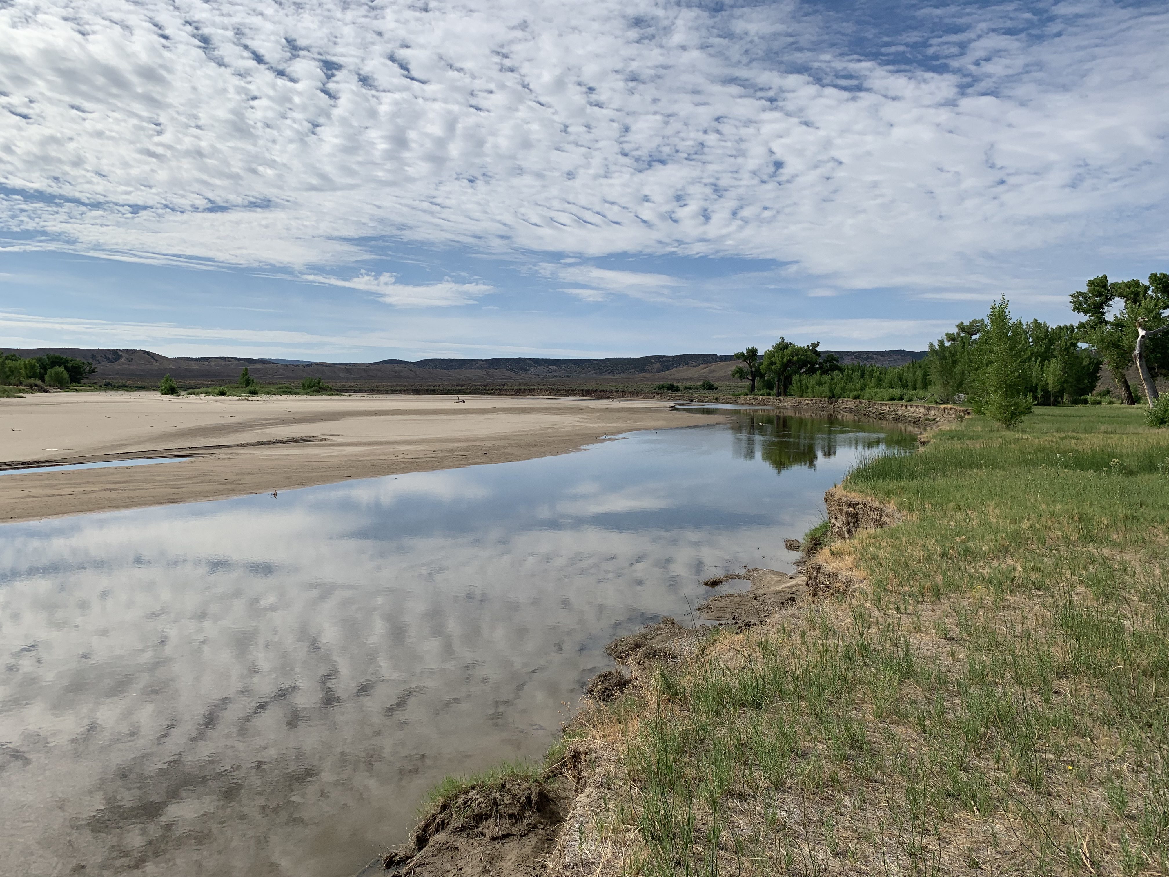
The Yampa River at Deerlodge Park July 24, 2021 downstream from the confluence with the Little Snake River. There was a ditch running in Maybell above this location. Irrigated hay looked good. Dryland hay not so much.
Muxworthy calls the Yampa River the “life beat of our community.” The description is apt. Kayakers paddle amid the waves during runoff months, and anglers drop lines every season. There are always people along the river banks.
In 2021, heeding local sentiment, the sustainability council launched a water-conservation program focused on outdoor use. Working with the city government and Mount Werner Water and Sanitation District, the group created a guidance document for landscapes called “Yampascaping.” Four educational workshops this year were well attended.
“Citizens are really interested in this because they see the impacts from climate change that we’re already having,” said Muxworthy, her organization’s soil moisture, water and snow program manager. “It’s really easy for them to make the connection and want to do something about it.”
The Mount Werner district, which serves the base of the city’s bigger ski area, offers rebates of $1 per square foot for turf removal.
Eighty miles south of Steamboat, at a 131-unit multifamily project along the Eagle River called The Reserve, turf-removal incentives of $2 per square foot have also helped the homeowners association replace a half-acre of thirsty grasses with native vegetation. The homeowners hope to replace another 60% of the more than 4 acres of common area.
Saving water is paramount in the mind of Deb Forsline, a director of the homeowners association. She sometimes lulls her grandchildren to sleep with the soothing sound at river’s edge and, at other times, accompanies her husband on fishing expeditions, knitting while he dangles lines. “It’s about saving water for the river, not the money,” she said of the efforts to reduce water for landscaping.
It’s all about saving water, says Deb Forsline, explaining the native grasses installed at The Reserve, a housing project at Edwards where she lives. Photo/Allen Best
Diane Johnson, communications and public affairs manager at Eagle River Water and Sanitation District, concurs. The $2 per square foot “helps move the thinking of people who have already been thinking about it,” she said.
Roman, the district’s general manager, points to the innate connection that most of her district’s 31,000 consumers have with the outdoors. “A lot of people who live here year-round know that it is irresponsible to overuse.”
A steeper staircase of water rates
After the 2002 drought, the Eagle River district adopted an inclining block rate structure. The more you use, the more you pay. The district got inconsistent results. Larger homes and those with more expansive and water-intense landscaping dropped their use in smaller percentages than smaller homes. The rate structure had been flawed, allowing larger homes to pay less per 1,000 gallons than smaller homes for the same volume of water. Different rates were needed to snag the attention of high-volume consumers.
Aspen had the same problem. It adopted tiered water rates in 2005. Managers thought the rates would discourage high volumes of consumption. But even in drought years, some properties continued stubbornly high volumes.
In 2017, Aspen adopted a new approach. The regulations require reduced water use in the landscape and irrigation plans for new and redeveloped projects. Such caps are called budgets. Like Denver and Boulder, Aspen has almost no new development of raw land. The law imposes a hard cap of 7.5 gallons per square foot of landscape. That’s about a foot of water, or roughly half of the supplemental water required in Colorado for Kentucky bluegrass. The law also requires so-called “smart” irrigation systems and alternative plants but leaves some flexibility in how developers and their consultants stay within the water budgets.
So far, 110 to 120 projects in Aspen have been reviewed, but only 15 to 20 have been executed – still too soon to discern clear results in water savings for the city, said Rob Gregor, utilities permit coordinator. Still, the city has leveled its water use and hopes to achieve even greater efficiencies in water devoted to residential and commercial landscapes. That could leave more water in Castle Creek and the Roaring Fork River, one of the goals of the program.
Durango, with 19,000 people and a projected population of 25,000 by 2035, has considered using rates to nudge high-volume users to less demanding landscapes. Justin Elkins, utilities manager, said the city hopes to encourage voluntary reductions in water use by allowing water users to monitor the volume of their use and compare it to consumption by their neighbors.
The Ute Water Conservancy District has successfully used rates to encourage water conservation. The Grand Junction-based district delivers water to rural and exurban areas of the Grand Valley from Cameo to the Utah border. Customers tend to be more responsive “when it hits them in the pocketbook,” said Andrea Lopez, the district’s external affairs manager. “As they use more water and enter into tiers that become steeper with the more they use, we usually see a reduction in use.”
That’s what Eagle River Water has done. Like Aspen, the Vail Valley has some wealthy homeowners. Under the old tier system, somebody in a smaller home paid more per gallon than somebody in a larger home, if they both used the same large volume.
Beginning in January, Roman was on the agenda of everybody from Rotary clubs to Eagle County commissioners. “Really, this is targeting our excessive users,” she told the Vail Town Council at a June meeting. “They’re the ones that are going to feel this.”
District directors in October approved the new tiered rates that intend to discourage high-volume consumption.
Linn Brooks uses about 7,000 gallons of water a month at her house in Avon after transitioning the yard to water-wise principles. Before, it used 15,000 to 25,000 gallons. Courtesy photo
In Wildridge, a neighborhood on the south-facing slopes of Avon, Linn Brooks has shown what is possible in landscape conversions. Fifteen years ago, before she started transitioning her landscape, her home used 15,000 to 25,000 gallons a month. Now, it uses, at most, 7,000 gallons a month and her landscape is commanding.
The takeaway, she said, is that communities can have vibrant landscapes and protect property values – and still use less water.
Next: How did bluegrass lawns in Colorado become the default? Some trace it to the castles of Europe. Half or more of Coloradans live in neighborhoods governed by homeowners associations. Some have started to curb thirsty bluegrass, but others needed a firm nudge this year from state legislators.
Allen Best, a longtime Colorado journalist, publishes Big Pivots, which tracks the energy and water transitions in Colorado and beyond. Aspen Journalism is a nonprofit, investigative news organization covering water, environment and community. This story is part of a five-part series produced in a collaboration between Big Pivots and Aspen Journalism. Find more at https://bigpivots.com and at https://aspenjournalism.org
Heroes are sometimes hard to find. However, in the world of protecting Colorado’s environment, culture and water resources, Colorado Water Trust is a hero.
I have served on the Board of Directors with Colorado Water Trust (CWT) for five years and am continually amazed with the projects, work ethics and involvement of the staff and fellow board members. The positive, “can-do” attitude is proving to be a model of what can be done to protect and improve our state’s river flows.
I became aware of Colorado Water Trust before joining the Board because of their efforts to maintain sustainable water levels in the Yampa River. As a non-legal, non-engineering individual in the water world, it was amazing to me that a non-profit had the interest and resources to purchase water for a struggling river system. My first thought was “they really care about agriculture”because this extra water meant ranchers along the Yampa River would be able to irrigate hay fields and pastures that were threatened with severe drought conditions. A search of CWT’s website opened my eyes to their mission, and I became intrigued with other projects.
Years later, through a strange set of events, I was asked to become part of their Board. They were looking to expand their representation throughout the state with people involved in day-to-day agricultural water and land use. I became a candidate, was accepted, and was thrilled with the opportunity to become involved.
CWT is striving to find solutions for many of the land use challenges facing agriculture: water equity, adequate water quantity, protection of natural resources, retention of properties for future generations, and respect for people who provide food and fiber to our country and world.
Much has been accomplished and there are many successful CWT stories. We have projects in process and potential proposals are being researched. There is much to do—and Colorado Water Trust is a positive leader in the efforts.
Hero is defined as a person who is admired or idealized for courage, outstanding achievements, or noble qualities. CWT is an organization that embodies that definition, and I am proud to serve on the Board.
Marsha Daughenbaugh Board Member, Colorado Water Trust Rancher, Steamboat Springs
Click the link to read the article on the Big Pivots website (Allen “You got the story right, without going too long” Best):
Colorado’s Just Transition legislation intends to help coal-dependent communities like this one ease into an economy after coal
Yampa, the town of 400 near the headwaters of the river of the same name in northwest Colorado, recently got a small grant from the state’s Just Transition program designed for coal-reliant communities.
You won’t immediately see the presence of coal in Yampa. You will quickly recognize that for hunters, wilderness hikers, and anglers, it’s a gateway to the Flat Top mountains with all of their wilds and mysteries plus the reservoirs that store their melted snow. At the head of one of the creeks is a narrow bridge of land above timberline called the Devil’s Causeway. Those with acrophobia need not cross.
Yampa also lies amid a valley of hay ranches, emerald in some seasons but always comforting in their relative emptiness. This is a valley that to some is best described as “Colorado as it used to be.” It’s not crowded, nor is there a rush. Not surprisingly, Yampa is on a Colorado Scenic and Historic Byway.
The coal is less obvious. The closest active mine, Twentymile, Colorado’s fourth largest, is actually about 50 minutes to the north along sometimes winding roads choked by oak brush.
Yampa’s economy is intertwined closely with that of coal extraction at Twentymile. Some coal miners and others directly associated with the mine live in Yampa. Others work on the railroad. There’s even a motel for railroaders built in the 1990s and a café, Penny’s Diner, created specifically to ensure that railroaders can get a square meal at all hours of the day.
The coal economy of northwest Colorado is on the decline. Most of the coal mined at Twentymile travels only a short distance, to be burned at the two units at Hayden operated by Xcel Energy. The same is true for mines in Moffat and Rio Blanco counties, whose coal mostly if not entirely gets burned at the three units of the Craig Generating Station. That plant is operated by Tri-State Generation and Transmission.
All five coal-burning units are scheduled to cease operations from 2025 to 2030.
Will the coal mines continue operations? That’s unclear. Peabody Energy, the owner of Twentymile, has not said for certain what it plans.
Without reservation it can be said that the shipments of coal from Routt County through Yampa and to markets elsewhere have significantly declined in the last 20 years. The official evidence is scant. Coal companies don’t release such reports. But the anecdotal evidence—what locals can report about the frequency of passing trains —is abundant.
In recognition of this impact, Colorado has awarded Yampa a $105,000 grant for implementation of a business support program. The money is to be used for purchase of new and upgraded equipment for local businesses.
Some of the money will also be used to install signs along Highway 131, which passes on the edge of town. Many travelers use the highway to get between Steamboat Springs and the I-70 corridor.
Colorado also awarded a $600,000 grant to the Pioneers Medical Center in Meeker for implementation of a new electronic medical health record system. That was identified as the first step to expand healthcare services and long-term plans to develop medical tourism. See: “Medical tourism in a land of fishing poles & orange vests”
Both grants come from state funding allocated to smooth the transition of coal-dependent communities during the energy pivot underway in Colorado.
New jobs will be the end result of the grants, according to a press release issued by Gov. Jared Polis’s administration.
“As the economy moves away from the high cost of coal power, Colorado is helping local communities diversify their economies and creating new opportunities for their residents to be successful,” said Polis.
Yampa, the town, lies at the head of the Yampa River drainage on the eastern flanks of the Flat Tops. Top, Twentymile Mine in 2022 was Colorado’s four largest coal producer Photos/Allen Best
Paul Bonnifield, a resident, rejects the characterization of the new grant for Yampa as being a “nod of the hat.” In the context of Yampa’s municipal government, “it’s a pretty danged big chunk of money,” he said when asked for his on-the-ground observations.
As a history professor at a college in Oklahoma, he had several books to his credit, including “Dust Bowl: Men, Dirt and Depression,” which was published in 1979.
While never completely abandoning his interest in history, Bonnifield decided to pursue a life of railroading on Colorado’s Western Slope. He was based in the nearby railroad community of Phippsburg for 25 years while working as a conductor on trains from Grand Junction to Denver before retiring in 2002. This writer became familiar with him when we met during the early 1990s at the Turntable, a railroad restaurant located adjacent to newspaper offices of The Vail Trail in Minturn. Both of us were regulars there for awhile.
At one time, far more trains traveled through Yampa, he said. A train from northwest Colorado, for example, delivered coal to a plant along the South Platte River near downtown Denver. That plant, Arapahoe Station, ceased electrical production in 2014. Trains also delivered coal from northwest Colorado to Texas.
Now, maybe one train a month exports coal out of the Yampa Valley. One train a week may travel through the town ferrying wheat and other goods from northwestern Colorado and delivering pipes and other supplies.
But the valley no longer has a maintenance crew and other railroad employees like it once did. As for the diner for railroad employees, it has had trouble finding enough local help to maintain reliable hours.
At the same time, local governments will enormously suffer from the eroded tax base if the mine closes.
These grants are an expression of Colorado’s commitment to ease coal-dependent communities economically as the era of coal, now more than 125 years old in Colorado, ebbs even more rapidly through the end of this decade. By 2031, the state’s remaining last eight coal-fired electricity-generating plants will be closed, casting doubt on the viability of Colorado’s six remaining coal mines.
The legislative roots were in 2019, when Colorado adopted what was then seen as ambitious—too ambitious, in the minds of at least some Republican legislators—decarbonization goals: 50% economy-wide decarbonization by 2030 and 90% by 2050, both compared to 2005 levels. The law was HB 19-1261.
In HB 19-1314, Colorado legislators declared that they did not want to throw coal workers in the mines, power plants, or on the railroad under the energy transition bus. Colorado had been mindful of impacts, the law said, and state government had a role in helping provide a transition for those people and their communities.
The state, Colorado’s law declared, had a “moral commitment to assist the workers and communities that have powered Colorado for generations” by supporting a “just and inclusive transition” away from coal.
It also noted that resources existed at neither the state nor federal levels sufficient to assist workers and communities impacted by the transition. That included the absence of coordinated leadership within Colorado’s state government.
The law appropriated a thin sum for staffing, not quite $157,000, with the understanding that more would come. Wade Buchanan, a veteran of several state positions, was hired to run the new Office of Just Transition.
Meetings in early March 2020 were held in Craig and Hayden. I attended all three. In Craig that first evening, I heard anguish and dismay about the announcement two months before by Tri-State Generation and Transmission that the three coal units it operated there would all be closed by 2030. Only one had been announced previously.
The third day, the governor arrived in Craig. First he toured a small shop, Good Vibes, that produces gear for river boaters. It was just the governor by himself with the two co-owners and me the observer.
That afternoon, he sat in the Hayden Town Hall listening to testimony when the news arrived. One coal miner from Twentymile pleaded with the governor to see a future that included coal. Polis seemed to be listening, but likely he had been told just a few hours before that Colorado had its first case of covid. Surely, he was thinking many thoughts.
Colorado put together a 20-page action plan by the end of 2020 that outlined 13 strategies for communities, workers, and funding. It also gained state funding.
Between the Office of Just Transition and its parent agency, the Office of Economic Development & International Trade, $9.62 million in funding in the form of coal transition community grants had been issued. They were:
Yampa Valley, $5,152,538
West end of Montrose County (Nucla and Naturita), $3,058,192
Pueblo County, $471,423
Morgan County, $471,423
$471,423 for Delta, El Paso, Gunnison, La Plata and Larimer counties collectively
So, money is getting distributed, lots and lots of meetings are being held now, and the Office of Just Transition is no longer a one-man office, as it was for the first year.
Antlers began operating in 1904, shortly before the rails of what many called the Moffat Road arrived. The principle figure in the railroad was David Moffat, whose name lingers on the tunnel through the Continental Divide, the county in northwest Colorado — and the street on which this business is located. Photo credit: Allen Best/Big Pivots
Yampa’s main street, Moffat Avenue, is wide and still largely without pavement. It has never had a large population, hovering between 300 and 400 in recent decades. None of the busyness of Steamboat Springs 40 miles to the north, or the Vail Valley communities, 40 miles to the south, can be found in Yampa. To most locals, that’s fine.
Still, a little more activity would also suit the locals, and that is how the town intends to use the money, to bolster business activity. Part of that plan is to ensure that the community has a restaurant open to the public on a year-round, not just seasonal basis.
Yampa has had a very fine restaurant called Antlers. The business was established in 1904, just before the rails arrived from Denver through the Moffat Tunnel on their way to Moffat County, and has been in operation continuously since then with the exception of 2005-2009.
The restaurant has now returned to operating hours year-round with some help from the town government.
The opening of Yampa Garage Eatery is another bright spot in the town’s economic story. The money will also help expand the space and variety of goods at the local grocery store and mercantile.
But 90% of the town’s workers leave to work elsewhere, points out Mary Alice Page-Allen, the town planner and treasurer.
The goal of her work, she said, is to “retain what we have, but also to expand and attract.” The town core lies just a block off the highway, but for many travelers, there may be no particular reason to pause on their journeys.
Oak Creek, a one-time coal-mining town 10 miles to the north, which Page-Allen formerly managed, has had some success in creating more buzz in its commercial district. It even has a parking problem a couple days a week.
That’s a hard problem to imagine for Yampa, but a few more cars on that big, broad street would be welcome.
Wyoming angler Jeff Streeter’s shadow casts over the shallow flow of the Encampment River, a tributary to the North Platte River, July 21, 2021. (Dustin Bleizeffer/WyoFile)
Click the link to read the article on the WyoFile website (Anne MacKinnon):
Climate change poses challenges for Wyoming water law, seen these days on the Grand Encampment River southwest of Saratoga.
The Encampment River valley is like many small, irrigated valleys in Wyoming. It was once the home of a few pioneer ranches that built a network of ditches, but the ranches have been divided up, the river has moved over time, and people have kept irrigating using the old ditches, sometimes with a little jerry-rigging. The Encampment valley is also narrow, with usually more than enough water, so state water officials haven’t had to “regulate” to keep water use in line with water rights.
Enter the Sinclair Refinery near Rawlins, Carbon County’s biggest employer. Its workforce includes people from the Encampment valley, located some 40 miles away. In just the last year and a half, the oil company that took over the refinery bought a ranch on the Grand Encampment River.
The attraction: the old water rights on the ranch. The goal: to bolster the refinery’s water supply in the face of climate change.
Two years out of the last six, the Upper North Platte Basin has seen climate change in low snowpack. It has meant that in spring, the refinery couldn’t legally use its own 100-year-old water rights. Refinery managers had to arrange for temporary use of older water rights from elsewhere. Buying the Encampment ranch offers the new refinery’s owners, called HF Sinclair, a more permanent solution for those low snow-pack years.
That has some neighbors worried. Now, how water works in the Encampment valley — which lands are irrigated or not, when and through what ditch — must be examined.
It might seem neighboring irrigators wouldn’t care if a ranch won’t use its water rights in some years. But in a classic Wyoming spot like the Encampment valley, where the water rights and ditches and the irrigation practices and the water table and the water runoff from irrigation are interwoven, the refinery’s water use could disrupt the current pattern.
The HollyFrontier Sinclair refinery in Sinclair, Wyoming as seen in July 2011. (James St. John/FlickrCC)
HF Sinclair’s plan will test the capacity of Wyoming water law to serve both the refinery and the Encampment irrigation community in the era of climate change. Will water officials’ decisions start to unravel the fabric of the community, as some fear, or will it leave that fabric substantially intact?
Map of the North Platte River drainage basin, a tributary of the Platte River, in the central US. Made using USGS National Map and NASA SRTM data. By Shannon1 – Own work, CC BY-SA 4.0, https://commons.wikimedia.org/w/index.php?curid=79266632
Most climate change headlines in Wyoming have focused on the Colorado River Basin, but the Upper North Platte River Basin — embracing both the Sinclair refinery on the North Platte and the Encampment River, a North Platte tributary upstream — has also gotten steadily hotter in the last 20 years.
HF Sinclair’s proposal to move water rights from one location to another — in response to the impending climate crisis — is a prospect that has long alarmed Wyoming irrigators. The fear is that “drying up” a ranch can damage local economies. Such moves were once mostly illegal in Wyoming, and many irrigators believe they still are. But 50 years ago in another national crisis — rising energy prices, creating demand for power plants in Wyoming — the state changed its law to allow such moves if they meet strict standards. There must, for instance, be proof of how much water was consumed at the original spot — no more can be consumed at the new spot, and the amount of water that used to return to the stream from the original irrigation must be left in the stream at that point.
Notably, HF Sinclair is not proposing to dry up its ranch with any such permanent move of water rights. Only in low snowpack years would the refinery activate a new arrangement — a proposed “exchange.” The plan is that in those years the refinery would legally get to use its rights on the North Platte despite low flows, while it would not irrigate its Encampment ranch at all in spring or summer. That would allow Encampment water unused at the ranch to flow down the North Platte to Pathfinder Reservoir as “makeup” water, as required by the Wyoming water exchange law.
HF Sinclair also says it will invest in the interconnected headgate and ditch system on the Encampment to make sure that when the ranch does not tap the Encampment River at all for a year, neighbors still get water for their rights.
There is heavy pressure for an uncomplicated review of HF Sinclair’s plan. The company does not hesitate to underline the implications for sustaining local jobs. To get approval, the company has hired a phalanx of high-powered law and technical people, including a former Wyoming State Engineer.
But leading irrigators on the Encampment have asked state officials for a thorough review — they don’t, however, want the cost and trouble of hiring lawyers and engineers to fall on them. The Wyoming Stock Growers, meanwhile, this summer called for public meetings on water changes as a review of Sinclair’s plans got underway.
Neighbors don’t have grounds to complain if a ranch just decides not to irrigate in a few years. But because HF Sinclair is proposing a legal change, the ranch neighbors have brought concerns to the state water officials who must decide whether to approve the exchange.
To get that approval, HF Sinclair must take two steps: first clean up the water rights on the ranch, and then get the exchange petition granted.
Cleanups are standard in places like the Encampment River, since actual use of old water rights in Wyoming often changes over decades, as streams move a little and ditches fall into disuse. Often old water rights must be identified and nailed down to the current use, at the expense of the right-holder. Sometimes, cleanups get complicated. The strict standards of Wyoming’s water-moves law can apply, if change over time includes water moving some distance.
HF Sinclair is asking for a simple cleanup, which could avoid that scrutiny. The company has filed documents to show that only relatively insignificant changes in irrigation have taken place in over a century of ranch operations — nothing that should invoke the scrutiny required for serious movements of water rights.
There are, of course, all kinds of questions that could arise in HF Sinclair’s cleanup: How much of the ranch’s Encampment River rights have actually been used, where and from what headgates? Does the groundwater level in low-lying lands mean that water consumption there can’t really be stopped, and maybe fields there haven’t required much irrigation water? Has enough irrigation water been used on other ranch fields to provide the proposed “makeup” water for the exchange?
How intensely to review HF Sinclair’s cleanup is a decision for the state Board of Control (the State Engineer and the superintendents of Wyoming’s four geographical water divisions). Then HG Sinclair’s separate request for an exchange – a transaction expressly encouraged by state law – goes to the State Engineer alone to decide.
It will take months or years to see how Wyoming’s water rights review process plays out in this case. And the practical impact may finally depend on how many low snowpack years the future holds for the North Platte Basin. But ultimately, what happens on the Encampment will say a lot about how the state’s water law system will handle the pressures on water that are brought by climate change.
Yampa River Basin via Wikimedia.
Relatively smooth approval of an exchange on the Encampment could encourage towns and industries in Wyoming’s Green and Little Snake River basins to seek their own exchanges. For them, exchanges could be a solution to water supply shutdowns threatened by climate change on the Colorado River. In recent years the State Engineer’s Office has suggested that exchanges could be useful for that purpose, using reservoirs as makeup water.
On the Encampment, HF Sinclair’s experts include former State Engineer Pat Tyrrell, former Division I Water Superintendent Brian Pugsley, and veteran water lawyer Dave Palmerlee.
The facts on the ground may well be such that the refinery’s proposal would easily survive any tough scrutiny. But the way the consultants have couched the requests makes it appear they’re betting they won’t trigger that kind of review, so they get approval — and relatively quickly.
The Encampment community’s fear of local damage has brought an audience to the normally unnoticed Board of Control meetings, however.
Nearby ranchers would like to see Sinclair offer a signed contract for the investment in headgates and ditches to secure access to all neighbors’ water rights. They don’t want to contend with Sinclair’s experts in formal hearings or appeals. But they do want a very careful state review.
To study 11 tributaries on U.S. Forest Service land in the Yampa River basin, organizers and volunteers are traveling four seasons per year by snowmobile, ATV, raft, four-wheel drive, mountain bike or on foot to test stream water quality. The goal is to collect water quality samples and data so that the tributaries can be considered for the Outstanding Waters designation program that helps to safeguard water quality. Jenny Frithsen, environmental program manager at nonprofit Friends of the Yampa, is leading the local Outstanding Waters two-year study and application process to determine if the candidate tributaries on Forest Service land qualify for the water quality protection program. The 11 streams are located in four general areas across northern Routt County and in Steamboat Springs, including Elkhead and First creeks in the west California Park area, middle fork of the Little Snake River north of Columbine, four tributaries that feed into the Elk River east of Clark, and Fish, Walton and Soda creeks near Steamboat.
Friends of the Yampa staff are working with the Colorado River Basin Outstanding Waters Coalition formed in summer 2022 to identify and try to protect “clean water” across the state and to designate more headwater streams as outstanding waters deemed worthy of increased protections by Colorado. Frithsen said similar studies are underway in the region, for example, in the Roaring Fork and Eagle River watersheds…
The water quality sampling at 13 different sites in the Yampa River basin started in summer 2022 and will be completed in spring 2024 with a decision on the designations in summer 2024, Frithsen said. The designation would not impact irrigation water rights that are based on water quantity but would serve as an added layer of protection from dangers to water quality from point-source pollution such as wastewater treatment plant discharge or runoff or discharges from mining. Outstanding Waters is the highest level of anti-degradation protection under the federal Clean Water Act, Frithsen said. The designation prevents new or increased sources of pollution, but preexisting uses such as grazing and recreation can continue at current levels as long as pollution is not increased.
The Outstanding Waters designation is awarded through the Water Quality Control Commission of the Colorado Department of Public Health and Environment. For a stream or part of a stream to qualify, the water must meet specific quality criteria gathered across 12 key parameters such as dissolved oxygen, pH, E. coli bacteria levels, nutrients, metals and water temperature. Partners on the local project include The Pew Charitable Trusts and two nonprofits, American Rivers and Mountain Studies Institute in Durango.
Water developers want to construct an $80 million, 264-foot-high dam on the West Fork of Battle Creek south of Rawlins. This artist’s conception shows what the reservoir would look like in a Google Earth rendition. (Wyoming Water Development Office)
More detailed analysis is underway for “less environmentally impactful” locations for the proposed 264-foot high concrete West Fork Dasm and 130-acre reservoir
Citing a need to examine alternative dam and reservoir sites, officials have pushed back the expected completion of the environmental review of the proposed and contested West Fork Dam.
The Savery-Little Snake River Water Conservancy and Colorado’s Pothook Water Conservancy District want Wyoming to build the 264-foot-high dam in the Medicine Bow National Forest and swap state land with forest service property to streamline and enable the project. Designed to meet irrigation desires and provide other benefits to Carbon County’s Little Snake River Valley, the proposed 10,000 acre-foot reservoir would flood 130 acres at the confluence of the West Fork of Battle Creek and Haggarty Creek.
But the proposed development in a steep, forested canyon drew opposition over its cost, location, need, efficiency and potential environmental impacts. Opponents have criticized a proposed land exchange between Wyoming and the Medicine Bow that would put the development site in state hands and construction more firmly under its control.
Wyoming, which would pick up the bulk of the initially estimated $80-million dam cost, favors that site and design, said Jason Mead, director of the Wyoming Water Development Office. Wyoming has touted the development as one that would meet late-season irrigation needs and provide environmental benefits too.
“When the state and [irrigation] districts went through the feasibility analysis, it was felt, based on the information, that the West Fork site was the least environmentally damaging practicable alternative,” he wrote in an email.
The U.S. Natural Resources Conservation Service anticipated completing a draft environmental impact statement in September. The review of alternative sites has added “a few months to the anticipated schedule” spokeswoman Alyssa Ludeke wrote in an email, but how long the delay might be is unknown.
A better solution?
Wyoming identified nine alternative sites, one or more of which will now be reviewed in depth in the draft environmental impact statement.
“We have to do a more detailed analysis to see if [they are] less environmentally impactful or provide a better answer, a better solution,” Shawn Follum, an engineer with the NRCS, said Friday. “While there’s a preferred alternative [at the West Fork site], that’s the very beginning, not a deal.
“We’ve not seen any indication that that site won’t be a possibility,” Follum said.
Agricultural lands in the Little Snake River valley on the border of Wyoming and Colorado. (Angus M. Thuermer, Jr./WyoFile)
Meantime, the Medicine Bow National Forest continues to work on a “feasibility analysis” to inform the Forest Supervisor whether to move forward with a land exchange for the West-Fork site. There’s no deadline for that yet, said Aaron Voos, the Medicine Bow spokesman, and no guarantee a land swap would take place.
“It is looking highly likely that one of the alternatives analyzed will include a non-land exchange option, such as a special use permit,” Voos said.
The Medicine Bow has been analyzing the feasibility of the proposed land exchange, Voos said. If feasible, the Forest Service would determine whether an exchange is in the public interest.
“‘Public interest’ is required to be addressed and will be heavily factored into the Forest Supervisor’s recommendation to proceed or not proceed,” Voos wrote in an email.
Wyoming shunned obtaining a special use permit for the West Fork site because environmental reviews and other regulatory burdens would have been more complex. If the reservoir land were instead exchanged and became state property, construction permitting would be simpler, according to state officials.
Wyoming may have underestimated the complexity of the undertaking, stating in a proposed contract that it expected 100 comments on the development plan with only 40 being substantive. Instead, people submitted 936 comments, of which 96% opposed the project, according to a tally by WyoFile.
The study’s delay is not a surprise, Mead said. “Oftentimes federal agencies want a little more information to determine if an alternative should be dismissed or not, or may want to reconsider other sites,” he said. The additional analyses will ensure “a reasonable range of alternatives” is considered, he said.
New work necessary for the draft environmental impact statement includes hydraulic analysis and other tasks, some of which may involve field work, Follum said. It’s possible that work could be delayed by snow, extending the task until next spring, he said.
The NRCS is leading the environmental study with cooperation from the Medicine Bow National Forest and other agencies.
Angus M. Thuermer Jr. is the natural resources reporter for WyoFile. He is a veteran Wyoming reporter and editor with more than 35 years experience in Wyoming. Contact him at angus@wyofile.com or (307)… More by Angus M. Thuermer Jr.
We’re in a bit of a holding pattern along the Colorado River today, at least in the Upper Basin: on the one hand, waiting for the Bureau of Reclamation to weigh the options for big cuts in Lower Basin use; and on the other hand, seeing the Lower Basin states trying to come up with a less painful set of big cuts to impose on themselves over three years, taking advantage of the big snow year that relieves a little (but just a little!) of the immediate pressure.
At any rate, it’s an opportunity for me to step back a step and try to restore something of the perspective with which I started these posts – ‘learning to live in the Anthropocene.’ I’ve been calling the posts ‘Romancing the River,’ wanting to work in the spirit of Frederick Dellenbaugh in his book The Romance of the Colorado River: making the story of the First River of the Anthropocene something to engage in rather than deny. But the stories keep getting lost in the avalanches of mostly dispiriting details coming down these days….
So anyway, today – an unremembered part of the story of Glen Canyon Dam. Last post, we explored the structure of the dam itself, a good solid Early Anthropocene structure. But today I want to explore the infrastructure of the dam. As with most dams, what you can see is not the whole thing, even physically. To get a firm foundation on bedrock for ten million tons of concrete, the builders had to dig out more than a hundred feet of rock, rubble and sand from the natural streambed. That hundred feet of dam below the streambed is the physical infrastructure of the dam.
But even before that digging-down could begin, a political, economic, legal and philosophical infrastructure had be cobbled together on which to erect the physical structure. Recent articles about the river and its troubles that try to offer any river history at all tend to give credit (or blame) for the dam to a large mass of ego and bluster, Floyd Dominy, but he was just the Reclamation Commissioner when the dam was legislated, a guy who wanted to build dams as big as his ego. He built the structure, but he didn’t assemble the legal and political infrastructure that enabled it.
The larger story of Glen Canyon Dam’s infrastructure is mostly, but not entirely, a story of the Old West – a story of the most serious attempt to achieve a working truce between the Old West and the New West. And for those with my tendency toward an iconoclastic interpretation of history, it was one of the final episodes (thus far anyway) in America’s semi-civil westward war between the advance of the well-defined and well-funded Industrial Revolution and the retreat of a vaguely defined agrarian counter-revolution. For a review of that semi-civil war, go to ‘Westward the Curse of Empire,’ April 4, 2022.
When we talk about the Old West and the New West, we are talking about two very different cultures. Most (over)simply, we can say that the Old West is the west to which people went to live and make a living developing and marketing the natural resources of the West; and the New West is the west where people who live in the urban-industrial realm go to play, to ‘recreate’ themselves among the natural wonders and magnificent scale of the West.
It is useful to make a further distinction about the Old West: it was populated by ‘settlers’ and ‘unsettlers’: the unsettlers usually arrived first, the human equivalent of a plague of locusts with a mining mentality (mining gold and silver, other metals, old-growth timber and grass) – a drive to get there first, get the goods, and get rich. The settlers, on the other hand, came to farm or ranch with the intention of staying and making a life, settling down, homesteading. Some of the farmers tended to be soil miners, but the ones who stayed were true agrarians, the counterrevolutionaries to the industrial revolutionaries.
People of course do come to live in the New West too, not just to visit: they are usually either relatively well-off people retiring, or professionals working remotely with incomes from elsewhere, or they are mendicant people like I was sixty years ago (relatively poor, mostly by choice) who work for the recreation industries set up for the people who come to play, in exchange for getting to live and play themselves among the natural wonders of the West.
The story of Glen Canyon Dam, and the counterrevolutionary effort to co-opt it, began in the years immediately following World War II. The Lower Colorado River Basin had already been transformed into a desert empire through the 1928 Boulder Canyon Project, completed just in time for Southern California to grow explosively through the war effort. The four Upper Basin states figured that they would get their day after World War II. And in 1946 the Bureau – eager to follow the creation of Hoover Dam and the desert empire with more river miracles – came out with a pamphlet: ‘The Colorado River: A Natural Menace Becomes a National Resource.’ In it the engineers presented a smogasbord of 88 possible projects, large and small, all in the four states of the Upper Colorado Basin. They cautioned that there would not be enough water for all 88, so there must be some choosing.
Palisade peach orchard
The principal architect for the legal, political and economic infrastructure underlying what came to be the Colorado River Storage Project was no larger-than-life figure like Dominy, but an unprepossessing Congressman, Wayne Aspinall, from Colorado’s West Slope and the river’s largest headwaters catchments. Aspinall did not stand out in a crowd, but he was savvy, and absolutely committed to the Old West as an economy of working people engaged in the production of resources needed in the larger society – and with a deep love for irrigated agriculture, having grown up with his father’s peach orchard in the Grand Valley after the Bureau’s highline canal brought them water.
He was a Democrat, an unlikely representative from one of Colorado’s most conservative districts, but he began his political career in the late 1920s as a common sense alternative to the mess the Ku Klux Klan had made everywhere in Colorado, and he kept getting re-elected to state, then national offices because he got things done.
When the West Slope sent him to Washington in 1948, he got appointed to the House Committee on Interior and Insular Affairs, mastered the arcane procedures of the House, and as the district kept returning him to office, he gradually ascended to the chair of that committee, which gave him a lot of power over the budget and operations of the Interior Department and its Bureau of Reclamation. He exercised that power so vigorously and, in the opinion of many of his colleagues, so arbitrarily, that House committee rules were changed after he left, to diminish the power of chairs who took the time to learn the rules well enough to manipulate them.
A bust of Wayne Aspinall, in Palisade, facing the Colorado River. Photo: Brent Gardner-Smith/Aspen Journalism
He also knew which way the tide was running in America. The 1920 census for the first time showed more people living in the cities than in the rural areas, and by the end of World War II, that imbalance was accelerating. (‘How ya gonna keep’em down on the farm, after they’ve seen Paree?’) His Old West constituency was being diluted by newcomers aghast at learning a few eggs had been broken in making the omelet they took for granted. The cities they came from were also needing more water, and Aspinall was often caught between constituents angry about yet another transmountain diversion, and east-slope movers and shakers angry about what he could not deny but could often delay.
Nonetheless, his Old West constituents knew where his heart lay, and returned him to Congress 12 times. That might have continued indefinitely, but his own Democrat party outgrew its working-class roots, became a big city party, and gerrymandered him into a mostly urban district where he could not win; he was ‘primaried out’ in 1972. It was probably time; he had become a lightning rod for the early naive-environmentalist movement, and being aligned with that movement myself, I felt naively righteous in voting against him. I still think it was the right thing to do then; he had become increasingly reactionary and defensive, at least as he was being reported in the newspapers. But given what I’ve learned about him since, and my ambiguous feelings about the New West that has replaced the Old West, and about the staggering march of American history in general – I wish I had cast that vote a little more humbly.
In the 1950s, however, Aspinall was just hitting his stride when the Bureau was ready to finish remaking the First River of the Anthropocene, and he jumped on the opportunity to do something big and (he hoped) enduring for the West he and his constituents believed in. More than any other single person, he laid the infrastructure for the Colorado River Storage Project. For better or worse.
The Bureau of Reclamation prepared this ‘overview’ of its Colorado River Storage Project (CRSP) in the mid-1940s. Not all of it happened as planned. The big Cottonwood Reservoir on the Gunnison River became the much smaller Blue Mesa Reservoir after objections from Gunnison residents. And the big Echo Park Reservoir on the Green and Yampa Rivers caused a national uproar that resulted in dropping it entirely. Credit: USBR (Click to enlarge)
The Colorado River Storage Project had to first be a really serious storage project, to assuage Upper Basin water users’ fears of a Compact call, which they thought would come even if nature, not human overuse, caused a shortfall in Lower Basin deliveries. Another time we will take a look at the Upper Basin Compact created in 1948, and the knots the four states tied themselves into, due to their Caliphobia. So the first charge to the Bureau was to build some big ‘holdover’ reservoirs on the scale of Mead Reservoir – dams capable of storing at least two years of inflow.
But the Bureau and Aspinall also wanted big hydropower units in those dams – ‘humming the tunes of endless wealth,’ as a bit of precious Bureau prosody put it. ‘Cash register dams’ was a more prosaic nickname for the big power-generating dams: they wanted the wealth so generated to be applied not only to paying off the big dams, but also to pay for a lot of smaller dams in the higher country.
The biggest problem farmers and ranchers in the arid lands had in irrigating from a desert river fed primarily by snowmelt was the erratic flows – snowmelt floods early in the irrigating season and then almost no water in the late summer when it was most needed. Storage to even out the flows was the key, and storage was expensive. Every community of farmers could go out after harvest with shovels, black powder and mule scrapers, and dig canals to move water, but water storage required materials and equipment they couldn’t afford. Every irrigation district had sketch plans for dams and reservoirs, but for small communities, the Bureau’s cost-benefit analyses for dam repayment were impossible.
But – if a general fund for a big multi-unit project could be created, with power revenues pouring into it, and some small storage projects drawing on it, with cost-benefit analysis calculated for the whole multi-unit project, then the big dams could carry the otherwise unaffordable little dams…. Glen Canyon Dam would (‘twas hoped) assure that the industrial revolution’s desert empire got its water – but it would also provide storage for the counterrevolutionaries’ ‘headwaters republics.’ Win-win.
And that was essentially the Colorado River Storage Project Aspinall and his collaborators in the Upper Basin put together. They started in 1950 with a bill calling for nine big holdover dams and reservoirs, and a couple dozen ‘participating projects’ (the smaller storage dams for the local communities). By the time they finally got the project through Congress in 1956, they were down to three actual holdover dams (Glen Canyon Dam on the Colorado mainstem and Flaming Gorge on the Green River, both with full power generating units, and Navajo Dam on the San Juan with no power unit), the Curecanti unit of three dams on the Gunnison that was primarily for power production, and eleven ‘participating projects’ to be partially paid for from the power revenues – and another two dozen potential participating projects for further study.
And because Aspinall knew the New West was coming, like it or not, the Act included a requirement that every unit would include recreational facilities.
Did it work out as planned? Yes and no. The ‘cash register’ dams were all built, and facilitated the building of around a dozen of the small ‘participating projects.’ My great-grandparents would have been glad for the dam built on the North Fork of the Gunnison River above Paonia, the erratic river whose spring floods had forced them to move their house to higher ground. But they had sold the homestead by the time the dam was built because none of their offspring wanted to contend with the erratic water supply.
Animas-La Plata Project map via USBR
By the late 1960s, however, the nation had grown tired of building (and paying for) western water projects, and NEPA and the advent of the Environmental Impact Study after 1970 made even small water projects problematic. The last project done under CRSP auspices was an Animas-LaPlata project originally intended to help the Ute Indians develop agricultural lands, but it got so scaled down that it was not much use to anyone.
By the turn of the century, ‘reclamation’ was more likely to be interpreted as work to reclaim and restore land and waterways damaged by the collateral debris that the Old West’s heavier industrial unsettlement left behind. Then in the 1980s a large portion of the power revenue from the big holdover dams was diverted from further CRSP counterrevolutionary structures, to an all-out effort to restore four endangered fish species that, back in the 1970s, the U.S. Fish and Wildlife Service tried to kill off by poisoning the Green River. Mistakes have been made, and visions and dreams got carried out with the debris.
The recreation industries, and the accompanying real estate and construction industries, have pretty much overrun and occupied Aspinall’s would-be agrarian republic; but there are, nonetheless, still places in the West where small farms and ranches hang on, some of them ‘heritage cultures’ passed on through families predating CRSP, some of them new and serious about growing local food – and many of them served by CRSP facilities generated by Glen Canyon Dam. But the agrarian philosophy and vision they represent is largely unarticulated in the mainstream culture; I believe, however, that a careful and potentially difficult interrogation of a large number of rural MAGA supporters would reveal that a virulent form of the agrarian counterrevolution still lives, mute but mad, in a twisted variant of unarticulated hope.
Just call it all another story in the romance of the Colorado River – the story of how Glen Canyon Dam was, for a time, put in service to another America.
A high desert thunderstorm lights up the sky behind Glen Canyon Dam — Photo USBR
Routt County Emergency Management is warning residents to expect flooding Thursday, May 4, into Friday, May 5, with the Yampa River anticipated to reach its highest level yet this season. Emergency Operations Manager David “Mo” DeMorat told Routt County commissioners on Monday, May 1, that the river had hit 6,500 cubic feet per second, and warm temperatures are expected to continue through the week, which could cause the river to reach 7,000 cfs by Friday. DeMorat said this amount of water for the Yampa River is considered “action level” flooding by the National Weather Service. Action levels generally require municipalities to keep a closer eye on flooding and have potential mitigation plans and flood warnings in place…
To gauge what flooding will look like, the county uses snow-water equivalent gauges that provide estimates for the amount of snowmelt that could occur three to four weeks out. This looks at the amount of snow on the ground, but cannot predict at what rate it will melt. Because of this, no exact estimates can be given, as it is ultimately the weather and the freeze-and-thaw cycle that will determine at what rate the snow melts.
DeMorat explained to commissioners that these gauges show areas north of Steamboat and the Stagecoach Reservoir currently have the highest potential for flooding. Three snow-water equivalent gauges stationed north of Steamboat have helped emergency management identify these regions as problem areas for flooding due to the snowpack that could melt. All three are north of Steamboat with one near Dry Lake, one near Lost Dog Creek and another slightly farther northwest. DeMorat noted these locations range from 165-185% of the average snowpack. He told commissioners that Stagecoach Reservoir is another area of concern with 140% of its average snowpack.
Alongside the problem areas DeMorat named, the National Weather Service issued a flood warning for Elkhead Creek, particularly where the creek meets the Yampa River. This flood warning began on Monday and will end Friday unless communicated otherwise by the National Weather Service.
In the first official scorecard of Yampa River system health, the middle section of the Yampa earned an overall score of B. That B means the middle Yampa River from Pump Station boat launch east of Hayden to South Beach about 2 miles south of Craig is a “highly functional river where some stressors are present but in general it remains largely resilient to disturbances and may rely on limited management,” said Jenny Frithsen, environmental program manager with Friends of the Yampa, which is managing the scorecard project. Within the overall score of B as part of the Yampa River Scorecard Project, the middle Yampa earns an A for dissolved oxygen, PH levels and metals in the water, “the only ecological indicators that got an A,” Frithsen reported.
The first results of the long-term scorecard project will be released fully in early May with information available at YampaScorecard.org. Data collection started in the middle Yampa in summer 2022, and the overall project will include five river sections.
During summer 2023, data collection will focus on the stretch starting from Chuck Lewis State Wildlife Area to the Pump Station boat launch.
The river scorecard is derived via approximately 45 different indicators in and around the Yampa River that fall under three main areas: ecological health and function, river uses and management, and people and community benefits.
“By seeing what areas are a C, D or F, we can now focus on action and how to improve these numbers,” said Lindsey Marlow, executive director for Friends of the Yampa. “We now have a template to start conversations with people in this basin about the health of the river and its ecosystem services.”
Marlow said another key finding that stands out is riverscape connectivity, or a measurement of the ease in which a river can move around such as a connected flood plain and river channel.
“There are areas that score so well at 95% and others that need help at 65%, and now we get to embark on the exciting task of figuring out how to improve floodplain connectivity,” Marlow said.
The Colorado River Water Conservation District predicts Elkhead Reservoir will overtop its spillway in mid-May with water exiting the spillway and outflow at a combined rate of about 2,000 cubic feet per second, or about the same level of peak water as in 2011, shown here on June 14, 2011. Stream bank damage is expected downstream in Elkhead Creek in May. Photo credit: Colorado River Water Conservation District
Last year, Elkhead Reservoir operators carefully managed the reservoir that straddles the Routt and Moffat countyline due to low water issues, but this year reservoir managers are facing challenges due to high water from abundant snowmelt in the Yampa Valley. Managers predict Elkhead Reservoir will top its spillway in mid-May with water exiting the spillway and outflow at a combined rate of about 2,000 cubic feet per second, or cfs, or about the same level of peak water as in wet 2011, said Don Meyer, senior water resources engineer with the Colorado River Water Conservation District based in Glenwood Springs.
“The current outflow is about 550 cfs with valves 100% open,” Meyer said. “When (the reservoir is) full, the release will be 590 cfs. When spilling, we will likely keep the outlet discharge at 590 cfs, and the rest will go over the spillway.”
Meyer, who has managed Elkhead Reservoir releases since 2007, said high water flows in 2011 recorded 1,800 cfs on May 8 and more than 2,000 cfs on May 16, May 24 and June 4. He expects 2023 spillage will follow a similar path…
The watershed upstream of Elkhead Reservoir drains a 205-square-mile basin, according to the river district that owns or controls water supplies that are available for contract to agricultural, municipal, industrial and other water users.
Five inches of snow falling ahead of closing day made 2023 the second snowiest season ever recorded at Steamboat Resort. Flakes fell throughout Friday, April 14, and continued into early Saturday, April 15, bringing the mid-mountain snow total on Steamboat’s snow report to 448 inches. There are some discrepancies on the resort’s snow report at Steamboat.com/the-mountain/mountain-report, as the sum of monthly totals is 459 inches. Nevertheless, 448 was all that was needed to become the second snowiest season at the resort, according to data collected by the resort since 1980. In order to become the second snowiest season on record, this year’s snowfall had to surpass the 447.75 inches that collected at mid-mountain in the 1996-97 season. The record of 489 inches set in 2007-08 will continue to stand at least for another year, as the resort will close on Sunday, April 16, and stop documenting snowfall…
While the melt was slowed by Friday’s snow and cold temperatures, the fluffy stuff is diminishing quickly. The snowpack or snow water equivalent in the Yampa, White, Little Snake Basin seems to have peaked on April 7, according to data from the United States Department of Agriculture…The presumed peak, which came 24 hours before the median peak based on 30-year averages, was 30.1 inches. The past two years peaked at 18 inches, or just below. The last year to have a similar peak was 1997. Between April 1 and 8, the area had record snow water equivalent as the measurement surpassed 29 inches and reached 30. With the melt, the 2023 snowpack is back below the record trajectory, which was set in 2011.
Yampa River flow hit 817 cubic feet per second on Thursday evening, April 13, which is four times greater than the flow of 204 cfs on the same day the year before, according to U.S. Geological Survey data. The Elk River hit a high flow of 1,700 cfs on Friday, April 14, more than six times the flow on the same day in 2022.
Wyoming Game and Fish Department comments cast doubt on irrigators’ claims that a 264-foot-high dam proposed in Carbon County will benefit fisheries, riparian zones and wetland-wildlife habitats.
The dam proposed for the West Fork of Battle Creek above the Little Snake River on the Medicine Bow National Forest would provide 6,000 acre-feet of late-season irrigation to ranches near Baggs, Dixon and Savery and in Colorado. The 700-foot-long concrete dam and associated 130-acre reservoir would also provide a “minimum bypass flow” to improve fisheries in downstream creeks and rivers, according to the proposal.
The reservoir itself could be a “brood facility” and refuge for native Colorado River cutthroat trout, a species of conservation concern, the Wyoming Water Development Commission and others say.
As dam backers’ plans were opened to formal public review and comment earlier this year, however, critics challenged the rosy ecological picture and accounting of public benefits claimed by water developers.
Among these critics is Wyoming’s own Game and Fish Department, which says construction and operation of the dam would cause “substantial negative impacts on the aquatic and fisheries resources in the West Fork Battle Creek, Battle Creek and Little Snake River drainages.”
Even though mitigation efforts are “likely” to offset such impacts and may conserve and enhance fish and wildlife habitat, the wildlife agency expressed reservations about the project.
“Given the complexity of ecological systems and inherent uncertainties about project operation and impacts and future climate and hydrology,” Game and Fish wrote in nine pages of comments, “it is not known if the proposed project will benefit fisheries, riparian, and wetland wildlife habitats, as suggested by the proponents.”
In-stream flow vs. bypass
Wyoming’s wildlife agency made its comments along with 935 other individuals and organizations as the Natural Resources Conservation Service, a federal agency tasked with aiding agriculture on private lands, analyzes the project through an environmental impact statement. Eight hundred ninety-nine commenters opposed dam construction and an associated land swap with the Medicine Bow National Forest that would enable it.
Game and Fish offered six pages of recommendations for how to potentially alleviate some of the dam’s impacts. Those include a program to wipe out non-native trout from a network of creeks that extends about six miles upstream of the dam site. Colorado River cutthroat trout would then be planted in an artificial “brood facility” in the reservoir and upstream.
The valley in which the West Fork dam and reservoir would be constructed. (Angus M. Thuermer, Jr./WyoFile)
In launching the plan to dam the West Fork of Battle Creek, dam backers declared benefits would accrue to “fisheries, riparian and wetland wildlife habitats, and water-associated recreation,” according to a legal notice published in the Federal Register.
“Ecological objectives … include improvements to aquatic ecosystems and riparian habitats by supplementing stream flows during low-flow periods, and … to terrestrial habitat associated with irrigation-induced wetlands,” the notice posted by the NRCS states. “Benefits are expected to accrue to these attributes [downstream] to the confluence with the Yampa River including improvements to both cold water and warm water sensitive species.”
Fisheries below the dam could benefit from 1,500 acre-feet earmarked for bypass flow, a 483-page Wyoming study says. Bypass water that would be released from the dam would maintain a minimum flow for about 4 miles downstream.
Nothing in the plan as currently written, however, would prevent any irrigator from taking water out of the creek below that point and using it for irrigation.
“Without an in-stream flow water right, once released from the bypass flow account in West Fork Reservoir, the water could be used or diverted for other purposes,” Jason Mead, interim director of the Wyoming Water Development Office wrote in an email. Nevertheless, “[m]ost of the water released solely for habitat flow purposes, according to hydrologic models, occurs during the non-irrigation season months,” Mead wrote. “[T]here are no irrigation diversions below the [proposed] West Fork Reservoir on the West Fork of Battle Creek or Battle Creek until it runs on to private land.”
‘Habitat units’
The 4.8-mile reach of Battle Creek that runs across private land would benefit from approximately 1,414 new fishery “habitat units” if the dam were built, according to Wyoming’s study. A “habitat unit” supports about one pound of trout per acre. Together, the new aquatic productivity “could facilitate additional private enterprise investment which could generate direct private fishing benefits of $144,228 annually,” the Wyoming Water Development Office says in the 2017 study.
That money would increase through an economic theory known as an “indirect benefit multiplier,” producing $379,320 in private benefits annually and $8.2 million over 50 years, Wyoming’s plan states.
Little Snake River agricultural lands along the Colorado-Wyoming border. Angus M. Thuermer, Jr./WyoFile)
That, plus other “instream flow benefits,” are estimated to generate $35 million in public benefits in the dam’s half-century life, the WWDO study states. All told, the state forecasts $73 million in public benefits. That sum justifies the state paying for most of the 2017-estimated $80 million project price tag.
“Given the unique location of the West Fork Reservoir project, its most valuable recreation attribute may be its isolated location which provides a sense of solitude that some recreationalists seek and consider priceless,” the state study reads.
In a comment letter, downstream ranch owners Sharon and Pat O’Toole said the proposed dam “offers multiple benefits,” and would offset the city of Cheyenne’s water diversions from the Little Snake River Basin.
“An environmental benefit would include creating and enhancing wetlands and riparian habitats upstream from the West Fork Reservoir, and improving stream habitat to sequester copper and other metals” from an abandoned mine, the O’Tooles wrote. “The created wetlands and improved stream channel could also provide wetland and stream channel mitigation for the project.
“Our family owns all the private land on Battle Creek,” the couple wrote, adding that “in the lower reaches we have Colorado Cutthroat Trout,” along with other species.
“Haggerty Creek [above the site of the proposed reservoir] used to provide habitat for this species of interest, and could again, with the benefit provided by the dam. The proposed dam would offer value to the recreating public. It would provide a fishery on Haggerty Creek and downstream that does not presently exist.”
John Cobb, chairman of the Little Snake River Conservation District, an irrigation group, wrote that there are “many self-mitigating aspects of this [dam-building] alternative with the potential to drastically offset any potential negative impacts.” Dam construction could “result in a net benefit to the native ecosystems and human economies that thrive within the proposed service area of this project,” his comment reads.
The project would also contribute to the goals of the Colorado-based Yampa, White, Green Roundtable, a consortium of river users, according Jonathan Bowler, watermaster for the Savery-Little Snake River Water Conservancy District that applied to build the dam. Among those is a goal to develop a system to reduce water shortages and meet environmental and recreation needs, he said in a presentation to the group.
Professional, expert critique
In addition to Game and Fish comments on the plan, reaction includes reviews and criticism from angling and conservation groups.
Wyoming proposes to swap state property for federal land to enable construction, and budgets $594,000 of the estimated $80 million project cost for wetland and stream mitigation, public documents state.
Without endorsing construction, Wyoming Trout Unlimited recommended that any plan include funding for non-native brook trout removal and other conservation measures, Kathy Buchner, Wyoming TU Council chair and two other TU officers wrote. Other groups were more critical.
Little Snake River watershed S. of Rawlins, Wyoming via the Wyoming Water Development Office.
“Five years of construction will destroy the present aquatic habitat for all populations of vertebrate and invertebrate species and terrestrial wildlife habitat,” wrote Brian Smith, a former Wyoming water development technician who operated the nearby High Savery Dam and Reservoir where Game and Fish established a similar Colorado River cutthroat trout reserve. “Spawning migrations that have occurred [in and above Battle Creek] presumebly (sic) since the last ice age by CRCT will be terminated. The Little Snake River Drainage is one of only 3 in the State of Wyoming, where the CRCT exist.”
The nonprofit American Rivers also criticized the state plan saying the proposed project could threaten year-round water in the Belvidere Ditch upstream of the proposed reservoir. That ditch is “a WGFD stocking source of cutthroat trout,” and disruption there could harm “these valuable populations.”
Matt Rice, the group’s Colorado River Basin program director, said threats to the ditch could damage “one of the only remaining healthy populations of cutthroat trout [and] could perhaps push the species sufficiently to the brink to merit a federally endangered listing.” The dam would further reduce flows downstream, including in the Yampa River “with additional consequences for protection and recovery of pikeminnow and other sensitive species,” Rice wrote.
A promise of ecological benefits downstream is unsubstantiated, wrote Ben Beall, Friends of the Yampa president. He said that was “a questionable claim given the project’s stated primary purpose is to supply late season irrigation water and the limitation of capacity of the bypass account in the reservoir.”
Forest staffer worried
Worries about the dam’s impacts and a lack of critical review emerged well before the NRCS opened the issue for comments. When the Medicine Bow began preparing for a potential land swap two years ago, a staff hydrologist became alarmed that the dam’s effects wouldn’t be thoroughly analyzed.
The Medicine Bow distributed a briefing paper to its staff that included language “taken from the water development justifications/benefit promotional material and adopted by FS management/lands staff w/o consultation of fisheries professionals,” Medicine Bow hydrologist Dave Gloss wrote to colleagues.
The Medicine-Bow distributed the briefing paper after dam backers had held several meetings with national forest officials and put the bureaucratic wheels in motion for the land exchange, according to an email chain obtained by WyoFile through a Freedom of Information Act request.
“There is much more to the aquatics story,” Gloss wrote, “including the upstream reaches above the reservoir not supporting fish populations due to metals contamination and dewatering from an irrigation ditch, the in-reservoir and downstream trade-offs from altered flow, etc.
“If I could achieve one thing related to this project, it would be an honest and critical look at the social and environmental effects …” Gloss wrote.
He held out little hope for that “honest and critical” look. “There are a lot of factors in play making that approach very unlikely at the moment …” his email read.
A Medicine-Bow spokesman earlier this year wrote that Gloss’s worries are now unfounded. In briefing papers like the one Gloss complained about, “external opinions are encouraged to be included in the full range of information, as they help give situational awareness,” spokesman Aaron Voos wrote in an email. Information in the briefing paper was appropriately cited to make clear it came from project proponents, he wrote.
Further the Medicine Bow will consider the social and environmental effects of the dam and a wide range of public input and values for the public lands, water and resources involved, Voos wrote. “That will be accomplished with the EIS. We are a cooperating agency in that process and will be involved.”
The Medicine Bow, however, has no plans to peer-review Wyoming’s study of public benefits that justifies state funding of the dam, Voos wrote. The NRCS also said it will not peer-review the 483-page Wyoming Little Snake River final report of 2017.
“At this time we cannot say whether or not the Little Snake River Supplemental Storage Level II Phase II Study Report will be used in the land exchange feasibility analysis,” Voos wrote. “[H]owever, it could be used as a reference document during the feasibility analysis or at other points in the land exchange and NEPA processes.”
Click the link to read the article on the Steamboat Pilot & Today website (Dylan Anderson, Tom Skulski and John F. Russell). Here’s an excerpt:
Hayden’s Dry Creek certainly didn’t live up to its name Thursday, as flash flooding from melting snow crested its banks around midnight. The floodwaters closed streets, Hayden Valley Schools, the town’s parks and a 38-mile stretch of U.S. Highway 40 to start the day…Many Hayden residents — whether they are new to town or have spent decades in the Yampa Valley — said they had never seen flooding like this before. While for part of the morning there was a true sense of panic in town, many residents were quick to pump water out of their houses, and their neighbors were ready to help…
While Thursday’s flooding was significant, officials expect flooding to continue as snow keeps melting. Water in Dry Creek was starting to rise again Thursday evening…Hayden officials closed several streets on Thursday as well, with Third, Fourth and Poplar streets all seeing significant flooding. The water submerged roads, flooded garages and made its way into some people’s homes…U.S. 40 was closed to through traffic between Steamboat and Craig until after 1 p.m. Thursday, though the road was largely free of the flooding. Rather, CDOT officials were concerned about a key bridge just west of Hayden, and waited for an engineer to inspect it before reopening the highway. The bridge may eventually close the highway again if floodwaters rise overnight after a day of melting, DeMorat wrote in his update.
Click the link to read the article on The Denver Post website (Bruce Finley). Here’s an excerpt:
Mountain snow-melting intensified this week with an unusually abrupt “flick of the switch” from cold to hot, leading to flooding that on Thursday cut off northwestern Colorado’s main transportation route and forced a shutdown of schools. The statewide heat that brought Denver temperatures to 85 degrees, breaking two records, combined with mountain snowpack more than a third above the norm, also has boosted the potential for early replenishment of water supply reservoirs, including those along the Colorado River…
But rapid melting here and around the Southwest this week has brought higher-than-expected flows in rivers, such as the Mancos River in southwestern Colorado, along U.S. 160, and in the Yampa River in northwestern Colorado, along U.S. 40…Water in the Yampa and tributaries on Thursday gushed over banks and submerged a bridge near Hayden, forcing state transportation officials to close U.S. 40, the main transportation route in northwestern Colorado, between Steamboat Springs and Craig…
As the Mancos River swelled near Cortez, Montezuma County officials who had anticipated possible flooding in May or June suddenly faced those perils a month early.
As snow keeps falling in Colorado, boosting some parts of the state to record-highs, plenty of powder has been stacking up in the state’s ski country. On March 23, Steamboat Resort took to social media to announce that their mid-mountain station had passed the 400-inch season total mark. Perhaps more impressive is the 500 inches of snow they report has landed on the ski area’s summit. Reported totals at the mid-mountain station and the summit are 401.5 inches and 507 inches, respectively…According to Steamboat Pilot and Today, this is only the 9th time the mid-mountain station has recorded more than 400 inches, with the last time being the 2012 to 2013 season, when 433 inches fell. The snowiest season on record was that of 2007 to 2008, when a total of 489 inches was hit…
The greater Yampa-White-Little Snake river basin that includes Steamboat Springs is currently at 147 percent of the 30-year to-date median snowpack. This isn’t a record high, but it’s close.
In the Steamboat Springs area, only the tops of fences remained above the deep snow. TO the North, along the Little Snake River, the snow is deeper yet. Photo/Allen Best
From email from Big Pivots (Allen Best):
During early March I traveled to Colorado’s Yampa Valley to see, hear, and feel what a big-snow winter looks like and to ponder the implications for the Colorado River. This has been an epic winter, both wondrous and awful.
Ranchers in that valley have long measured snow depths against three-wired stock fences. In Steamboat Springs and along flanks of the Park Range, it’s three wires and more. Nearing Hahns Peak, only dimples in the snow marked the tops of fence posts.
Along the Wyoming-Colorado border, rancher Patrick O’Toole reported that this has been the hardest winter since he arrived in 1976. That includes 1983, when snowstorms persisted until June, catching Colorado River water managers flat-footed. Gargantuan flows into Lake Powell nearly ruptured Glen Canyon Dam.
“This year is more,” said O’Toole.
O’Toole’s family operation moved 7,000 head of sheep from winter range north of Craig to more hospitable desert range. The deep snow, cold, and winds that seem to be worsening were too much for his woolies. He told of pronghorn antelope left behind, some just lying along roads, too weak to stand.
“And there’s a lot of winter left,” he said.
Six elk stood along banks of the Yampa River near Craig on Sunday, March 19, 2023 as another storm moved in. Photo/Allen Best
In Craig, walls of icicles hung from roof edges, and the motel parking lot had snow and ice a half-foot thick. Along the edges of the frozen Yampa River, six cow elk huddled, looking perplexed, as another storm moved in. Glancing at my phone, I saw that in Denver, the temperature was near 50. In the opposite corner of Colorado, Lamar had been warned of potential prairie fires.
Driving twisting, snow-covered county roads made me tense, but the whitened landscapes blanketed by snows filled me with joy. My mind’s ears erupted in the chorus from Bach’s “Hallelujah.”
The Steamboat ski area surpassed last season’s total snowfall in mid-January. In the town itself, banks of carefully placed snow head-high and taller form a labyrinth of slots and passages, the city’s streets, sidewalks and driveways. Mindful that spring will eventually arrive, city crews have already ordered sandbags.
Nobody can know for sure when melting will begin in earnest. Along the Elk River, north of Steamboat, Jay Fetcher has faithfully recorded the day each year that the final snow on his pasture melts. His father began the records in 1949. The “snow off meadow” date varies, as do the snowpack and temperatures, but has arrived on average one day earlier every five years.
Will this epic snowpack end the drought, fill Lake Powell, and cause Colorado River states to get chummy instead of testy?
It’s still early March. Much uncertainty remains. The Upper Colorado Basin River Forecasting Center report on March 1 projected runoff for the Yampa and White rivers at 120% to 170% of average as defined by runoff totals during the last three decades.
Will the weather stay cold and snowy or, as has happened in some recent years, will turn warm and dry in April, May and June? In 2020, for example, a mid-March snowpack of 108% snow-water equivalent yielded runoff of 79% of average. On the Colorado River altogether, an average snowpack that year yielded runoff 52% of average.
How much melted snow will the thirsty soils sop up? Last year’s summer rains restored the soil moisture somewhat in northwestern Colorado, but they remain subpar and thirsty. Runoff will again underperform the snowpack.
It’s also useful to note that not all sub-basins in the Colorado River Basin have had the same plentitude as the Yampa. On the Green River, upstream of Flaming Gorge Reservoir, the runoff is forecast to be only 84% of average.
As for Lake Powell, the runoff from the Yampa can only help—but only so far. It was 21.8% full on Tuesday, March 7. One winter’s heavy snows will not refill it, though. Colorado State University climate researcher Brad Udall told KUNC’s Alex Hager in January that it will take five or six winters of 150% snowpack to refill Powell and Lake Mead.
Filling Flaming Gorge and other upper-basin reservoirs drawn down to keep Powell levels high enough to produce electricity need to be refilled. Peter was robbed to pay Paul. Now Peter’s pockets need replenishing. That will take time, too.
This has not been drought, as conventionally understood. Udall and other climate researchers call it a “hot drought,” the result of rising temperatures caused by atmospheric pollution.
“We are not changing any of our tactics based on one year,” said Lindsay DeFrates, a spokeswoman for the Colorado River Water Conservation District in Glenwood Springs. “It’s such a long game. We need to be sure we are prepared for a hotter, drier future.”
This year’s epic snow in the Yampa Valley means plenty of water for ranchers to grow grass this summer. Beyond that, little can be said.
Allen Best tracks the energy and water transitions in Colorado and beyond at BigPivots.com. He welcomes comments and contributions.
Snow blankets buildings and all else in Steamboat Springs. The larger of the two ski areas there had received as much snow by mid-January ad it did all of last season. Photo/Allen Best
Hopes to forge a plan to reduce Colorado River Basin water use by 15% to 25% this year disintegrated this week with dueling proposals that pit California against Arizona and other basin states, including Wyoming.
That leaves the U.S. Department of the Interior and Bureau of Reclamation, which issued the water-savings challenge in June 2022, to potentially impose their own plan to cut releases from Lake Powell and Lake Mead to maintain hydropower generation.
“Given the magnitude of water-use reductions that are being considered, talks between the Basin States have been very difficult at times,” Wyoming State Engineer Brandon Gebhart said in an email to WyoFile.
Dueling proposals
Responding to a Jan. 31 deadline, Wyoming joined fellow Upper Colorado River Basin states — as well as Nevada and Arizona in the Lower Basin — in supporting a proposed “consensus-based” model for better accounting of actual water supplies, including water losses due to evaporation and seepage at Lake Mead. That framework, if implemented, should result in a water savings of 1.5 million acre-feet to 3.3 million acre-feet of water, according to a letter signed by water officials representing the six states.
A pump pulls water from the Green River at a Sweetwater County-managed recreation area Sept. 27, 2022. (Dustin Bleizeffer/WyoFile)
But those proposed water savings may not be fully realized this year. Plus, the six-state proposal leaves open the prospect for major water cuts this year to the Lower Basin states, particularly California — the largest consumer of Colorado River water in the system. California countered this week with its own proposal for short-term water savings that would maintain the state’s bargaining power rooted in its senior water rights. That plan would shift the burden of water cuts to Arizona, which has water rights that are junior to California’s.
“I think that’s why Arizona was quick to jump on the letter with the other six states,” Great Basin Water Network Executive Director Kyle Roerink said.
Arizona prefers the consensus-building approach to sharing the pain of water-use reductions, Roerink said, over a strict adherence to the legal framework to restrict water use among those with the most junior water rights.
“In both letters, you have some serious shots across the bow as it relates to litigation and political posturing,” Roerink said. “And no one is calling on the Congress to fix this.”
Although the six-state proposal that Wyoming signed on to doesn’t commit specific, voluntary water-use reductions, it’s a necessary “next step toward a consensus solution,” Gebhart said.
Buckboard Marina owner Tony Valdez stands next to a stake that indicates the extent of lowering water levels at Flaming Gorge Reservoir Sept. 26, 2022. (Dustin Bleizeffer/WyoFile)
“As we continue the process, we try to understand and respect the very difficult realities being faced by California and the other Basin States,” he said. “We remain committed to working with the other Basin States and impacted water users to find consensus solutions.”
Despite varying legal positions and dire circumstances faced by each Colorado River stakeholder, some observers say Wyoming and the other Upper Basin states have offered up too little to help address the immediate problem that threatens some 40 million people who rely on the river.
“The Upper Basin is getting off scot-free,” Roerink said. “Plus, there’s no prohibitions put forth on potentially new development of Upper Basin water, like the West Fork of Battle Creek, for example.”
Wyoming’s role
Regardless of what new actions the federal government may take in coming months, the Bureau of Reclamation will continue to rely on releasing extra volumes of water from Flaming Gorge Reservoir on the Wyoming-Utah border to help balance levels at downstream reservoirs, according to those close to the issue.
The bureau enacted extra releases totaling 625,000 acre-feet of water from the reservoir since 2021, and is expected to announce additional releases in April or May. Flaming Gorge was at 69% capacity in January, according to the bureau. If that continues into the summer, many boat ramps will be left high and dry threatening the local recreation economy.
Meantime, Wyoming and the Upper Colorado River Commission are encouraging voluntary water conservation, soliciting interest in a program that pays irrigators, municipalities and industrial facilities to leave water in streams that flow to the Colorado River.
This week, the UCRC extended the application deadline for the System Conservation Pilot Program to March 1. Wyoming officials expect to receive 15 to 20 proposals from individual water users in coming weeks, according to the state engineer’s office.
For more information about the SCPP, visit the UCRC’s website.
Green River Lakes and the Bridger Wilderness. Forest Service, USDA, Public domain, via Wikimedia Commons
A member of the public poses a question during a public meeting in Saratoga Jan. 12, 2023 regarding the proposed West Fork Dam and reservoir. (Dustin Bleizeffer/WyoFile)
The U.S. Natural Resource Conservation Service will likely request some $20 million for the West Fork Dam on the Colorado border, a potential new funding source for the contested project
The federal Natural Resources Conservation Service will likely request funding “in the over-$20-million range” to help finance a controversial dam proposed for the Little Snake River drainage, a federal official said last week.
The revelation emerged from a long-awaited series of public meetings in Craig, Colorado, Baggs and Saratoga during which project critics and proponents interrogated state and federal agency representatives and argued the merits of the West Fork Dam initiative.
Estimated in 2017 to cost $80 million, the 260-foot-high concrete structure and accompanying 130-acre reservoir in Carbon County near the confluence of Battle and Haggarty Creeks has become the latest skirmish line in the West’s interminable water wars.
Water developers and many in the local agricultural community hail the public work as a critical tool for mitigating the effects of deepening drought and a boon for wildlife, recreation and the local economy. Opponents describe it as an expensive boondoggle poised to benefit a small number of irrigators — many of whom aren’t even in Wyoming — while shifting negative environmental impacts downstream.
Following years of quiet agency maneuvering, legislative negotiating and campaigning from both sides, a framework for the potential deal has taken shape. It involves a state-federal land swap, complex “public benefit” calculations, a streamlined environmental review, majority funding from the state of Wyoming, minority contributions from water-users and now, apparently, a potentially skid-greasing influx of federal dollars.
The NRCS’s funding interest was “some new info,” according to a participant at one of last week’s public meetings.
The Natural Resources Conservation Service will request funding if it and other agencies approve construction, said Shawn Follum, state conservation engineer with the NRCS in Casper.
Funds aren’t guaranteed, he said; “We can’t commit Congress’ dollars in the future.” But the money could qualify as the required contribution from the Pothook Water Conservancy District of about two dozen irrigators in Colorado, according to discussions at the public meetings.
Wyoming may still face challenges funding the dam if federal officials approve it. In an unprecedented move in 2018, state legislators cut some $35 million from a water-construction bill and required lawmaker approval for any new funds for the West Fork Dam.
In an era of infrastructure and stimulus funding, however, more federal money might be available. “The reality is there are a variety of places where to find this … funding,” rancher Pat O’Toole, a project proponent and former state lawmaker, said.
Funding, however, is only one of many variables that need to be solved for if the complex public works proposal is to come to fruition. The terms of a land swap and parallel environmental review are also top of mind for stakeholders, as is an evaluation of who actually stands to benefit from the undertaking.
‘Somewhat befuddled’
Held over three evenings, the meetings drew about 150 people to hear how the NRCS and Medicine Bow National Forest might authorize the proposed dam on the West Fork of Battle Creek.
In what’s being called a “parallel process” The Medicine-Bow will decide whether to exchange land to enable the 130-acre reservoir that would hold 10,000 acre-feet, mostly for late-season irrigation. About 44 irrigators have expressed interest in buying the water, according to discussion at the meetings.
Pat O’Toole, who ranches in the Baggs area, was among participants at the Saratoga public meeting on the West Fork Dam on Jan. 12, 2023. Approximately 150 persons attended three sessions — also held in Baggs and Craig, Colorado — explaining how the Medicine Bow National Forest and U.S. Natural Resources Conservation Service will decide whether to authorize a 264-foot concrete structure. (Dustin Bleizeffer/WyoFile)
Participants called the bifurcated approvals confusing and criticized the process that, according to Wyoming officials, is designed to skirt more lengthy federal environmental reviews.
“A lot of questions are coming from people who deal with this [National Environmental Policy Act] process a lot and they’re somewhat befuddled,” said Jeb Steward an Encampment resident, former state representative and a former member of the Wyoming Water Development Commission who has worked as a water rights consultant in the area.
Meeting participant Soren Jespersen said officials had created a “very confusing process, and it’s difficult … for the public to know when and how to weigh in.”
Cindy McKee, a rancher who irrigates from a stream above the proposed dam, and grazes cattle on state land that’s offered in the swap, echoed those concerns. “We’ve been very disappointed in the lack of communication from the state, as singularly affected as we are both by the land trade and by the proposed water project,” she said. “We were never notified that our [grazing] lease was up for consideration for the land trade. Fourteen years ago when the dam was conceived, we didn’t know about it for two years.
“It’s been difficult, quite honestly, to find information,” McKee said. “Documents are usually released very shortly before an opportunity to public comment. It’s been frustrating and discouraging.”
Comments and public interest
Federal and state officials stressed that comments about the review’s scopeshould be made in writing to the NRCS by Feb. 13. Only persons and organizations that comment can later object to any decision.
An NRCS draft environmental impact statement is expected in September with a final version released in April 2024 and adoption scheduled for that May.
Oak Creek could save “millions” off the projected $14 million price tag for fixes at Sheriff Reservoir after updated engineering on the project showed the town’s water source needs a much smaller spillway than originally thought. While the town previously believed the new spillway needed to be 300 feet wide, the updated work shows it only needs to be about 60 feet wide, according Steve Jamieson, an engineer with W. W. Wheeler that has been consulting for the town on the project. That is still twice the size of the existing spillway…
The recent work resulted from a Comprehensive Dam Safety Evaluation, which looked at ways the dam could fail during normal loading, flood loading and earthquake loading. The highest risk found was due to a gate failure, something that Jamieson said isn’t surprising as the town works to replace the original head gate on the nearly 70-year-old dam. Oak Creek has gone through a bid process for this work twice, but each effort failed to find a contractor the town could afford. A gate failure wouldn’t lead to loss of life, the analysis showed, but it would compromise the town’s water source, making the impact significant. The new risk identified is called a “liquefaction failure,” and it is related of the area’s seismic activity. While noticeable earthquakes are not common in Routt County, they are not unheard of. Since 2000, Routt County has seen approximately two-dozen earthquakes, with the largest being a 3.5 magnitude event about 10 miles northwest of Oak Creek in 2011, according to the U.S. Geological Survey.
The upper reaches of Haggarty Creek on the Medicine Bow National Forest. (Angus M. Thuermer, Jr./WyoFile)
Click the link to read the article on the WyoFile website (Angus M. Thuermer):
Above the Colorado-Wyoming border, the Sierra Madre Mountain snowpack holds water that ranchers say flows downstream too fast. Some question whether a proposed 10,000-acre-foot reservoir is pork or progress.
As officials this week outline plans for a 264-foot-high concrete dam proposed for a wooded canyon in the Medicine Bow National Forest, irrigators and critics remain divided over the project’s benefits and impacts. The two sides disagree whether the estimated $80-million structure and accompanying 130-acre reservoir are pork or progress, boon or bane.
Federal officials begin receiving public comments on the proposed dam on the West Fork of Battle Creek in Carbon County as ranchers and environmentalists disagree over whether 450,000 cubic yards of concrete should plug a forested gorge and whether federal and state agencies are conducting environmental examinations appropriately. In what one official admitted is a complex process with parallel reviews, two federal agencies will make key findings to resolve the project’s fate.
The federal Natural Resource Conservation Service will examine dam construction and alternatives in an environmental impact statement. Meantime, the U.S. Forest Service will launch a separate “feasibility study” todecide whether it should take part in an estimated 6,282-acre land exchange facilitating construction of the dam. The study will determine whether trading the federal dam site to Wyomining “is in the best interest of the American public,” Medicine Bow spokesman Aaron Voos said.
Proponents want the dam and reservoir to yield 6,500 acre-feet of late-season irrigation for between 67-100 irrigators in Wyoming and Colorado. The 10,000 acre-foot impoundment would hold 1,500 acre-feet as a minimum bypass flow for fish and wildlife. The state would pay for most of the estimated $80 million cost, a figure calculated in 2017.
“We would like to have a project here because it’s good for our valley,” said Pat O’Toole, a former state representative who ranches along the Little Snake River. “The public interest is clearly that the storage project [aids] biodiversity” and boosts food production while creating “a really healthy landscape.”
[…]
The land exchange is an end-run around environmental reviews, he said, an assertion dam supporters and review agencies reject. [Gary] Wockner is worried that Medicine Bow officials won’t apply the same scrutiny to the land exchange that they would to the construction of a dam on National Forest property, he said. Building on federal land would require a more extensive review, he said, echoing dam backers’ own public statements.
Medicine Bow spokesman Voos rejected the assertion his agency is shirking its responsibilities. It is speculation to assert what level of review a proposal to build the dam on federal property would require, he said.
Wyoming agrees the process is sound. “It wouldn’t limit the environmental review at all,” Jason Crowder, deputy director of the Office of State Lands and Investments, told WyoFile.
In addition to its public-interest swap determination, the Medicine Bow is participating in a separate environmental impact review and statement — conducted by the Natural Resources Conservation Service — that will consider environmental and social impacts of dam and reservoir construction and operation. All that “satisfies the environmental review requirements for the land exchange,” Voos said.
Dwindling basin flows
At the upper reaches of the Colorado River Basin, where dwindling flows put seven Western states and Mexico at odds over historic and future use, the project comes at an uneasy time. It will test Wyoming’s willingness to impound and use what it believes river laws allow, despite an arid landscape of dwindling Colorado River flows, oversubscribed demands, climate change and growth.
Federal regulations state that a land exchange can take place only if the public interest “will be well served.”
One benefit to the Medicine Bow could be acquiring 640 acres of state-owned school-trust sections inside the national forest. “Quite a few of them are either in or adjacent to [a] wilderness area or roadless areas,” said Jonathan Bowler, watermaster for the Savery-Little Snake River Water Conservancy District.
Little Snake River agricultural lands along the Colorado-Wyoming border. Angus M. Thuermer, Jr./WyoFile)
“The public could potentially see an expansion of roadless and wilderness in those areas,” he said.
The reservoir itself would flood land within about a half mile of the boundary of the Medicine Bow’s 31,057-acre Huston Park Wilderness Area, according to maps.
Bowler outlined other ways existing irrigation aids the environment; the dam would expand those benefits.
“You’ve got hundreds of ranchers pretty much doing the work of beavers to build riparian areas and habitat,” he said. Such irrigation-induced wetlands today cover more than 7,000 acres in the area, he said.
Birds and water at Bosque de Apache New Mexico November 9, 2022. Photo credit: Abby Burk
Irrigation aids amphibians and species like sandhill cranes that migrate to the Bosque del Apache National Wildlife Refuge in New Mexico, he said. “Our irrigation actually directly benefits that mating grounds down there that’s quite a tourist attraction.” Elk and other wildlife benefit from the open private land, he said.
Irrigation “basically fills up the soil … the largest reservoir that we have,” he said. When that moisture starts coming back out to the river, “that means that our rivers are higher [in] flow [in] late summer, early fall than historically they were.”
Wyoming calculates those returning flows — about 45% of what’s diverted onto fields — as water that can be used for irrigation again and counted as a benefit, according to a Water Development Office study.
“That late-season irrigation especially can help cool down river temperatures, which helps to provide for those big game populations as well as fish and other wildlife,” Bowler said.
Cutthroat trout historic range via Western Trout
The dam also could benefit Colorado River cutthroat trout because it would be an upstream barrier to competitors, helping fisheries managers enlarge a sanctuary for the species in and above the reservoir.
Said O’Toole, “this is may be as conservation-minded a place I know of in the western United States.”
Environmental review
…Wyoming wants 1,700 acres of Forest Service land for the dam and would analyze the value of between 2,024 and 4,400 acres of Wyoming school-trust land inside the Medicine Bow for the trade. Public announcements differ over the state acreage to be considered for trade.
The valley in which the West Fork dam and reservoir would be constructed. (Angus M. Thuermer, Jr./WyoFile)
State and federal officials agree a land swap would make approval of the 130-acre reservoir easier. Wyoming’s exchange request states that a land swap “would eliminate the need for a USFS special use permit.”
Federal land ownership of the dam site “adds millions of dollars to that [permitting] process,” Harry LaBonde, former director of the WWDO told lawmakers in 2018. “Dealing with the Forest Service … very much complicates the NEPA process,” he said, and an exchange “very much streamlines” potential development.
Dam proponents “were running into a bit of a roadblock with Forest Service on Forest-Service-managed land,” OSLI Deputy Director Crowder told the Wyoming Board of Land Commissioners in 2021.
The Medicine Bow told Wyoming officials that building on federal, not state, land “would not be the best approach just due to all the regulations that would come along with a [required] special use permit,” Voos said in an interview. “And so I think that [land swap] has been our suggestion.”
The value of exchanged parcels can be balanced by adjusting the acreage or paying for a difference, according to Wyoming’s proposal.
Any increase in federal acreage — the state offered 4,400 acres for analysis and potential trade for 1,700 acres of Medicine Bow land — could run afoul of Carbon County’s Natural Resource Management Plan. That plan supports valuable exchanges but also calls for “no net loss of private or state lands in exchange for federal lands.”
Gov. Mark Gordon, too, “is not supportive of the federal government expanding their [sic] estate in Wyoming,” Gordon’s spokesman Michael Pearlman told WyoFile when the governor protested the 35,670-acre conservation purchase of the private Marton Ranch along the North Platte River last year.
Of the 1,700 acres of Medicine Bow property Wyoming would acquire, the state wants 1,336 acres for the dam and reservoir itself and another 426 acres covering parts of Haggarty Creek and the Belvidere Ditch, site of a water spatamong area irrigators.
Owning all the property would “provide for the efficient operation of the reservoir and surrounding lands,” the state said in its land-swap proposal.
The state would lease the newly acquired land to the Water Development Commission, which would eventually transfer ownership to Carbon County or some other entity, according to plans. That final owner would be responsible for compensating the school trust — whose land the state would trade away.
A mining company that owns land at the reservoir site also would be involved with the project. American Milling LP of Cahokia, Illinois owns about 124 acres inside the national forest at the proposed site of the reservoir. The Carbon County assessor lists the market value of the property, site of mineral claims, at $40,675. Wyoming would presumably have to acquire that property too, or somehow arrange for it to be flooded.
WyoFile did not receive a response to a certified letter sent to the company seeking comment on Wyoming’s plans to inundate the private land.
Equal values
The Forest Service must show that values and public objectives of the state parcels “equal or exceed” those that would be swapped, regulations state. Medicine Bow land that would become the dam site must “not substantially conflict with established management objectives on adjacent Federal lands,” the Forest Service said.
Medicine Bow officials last week couldn’t immediately outline those objectives.
A WWDO study, however, listed the benefits of a new dam, saying it would generate $73.7 million in public benefits. Reservoir releases would be coordinated with those from the High Savery Dam.
A fish barrier on Haggarty Creek provides an upstream sanctuary for Colorado River cutthroat trout. (Angus M. Thuermer, Jr./WyoFile)
Critics have questioned the accounting of benefits, including rosy projections for recreational revenue and the acreage that would benefit from irrigation.
The cost/benefit ratio allows the state to reduce the required contributions from irrigation districts from the typical 33% to 8% of construction costs.
Wyoming, however, has seen costs for dam construction increase dramatically in recent years, potentially upsetting the cost/benefit ratio. The environmental review will update those figures, Jason Mead, interim director of the WWDO, wrote in an email.
Construction would require an estimated 450,000 cubic yards of concrete, according to an application to appropriate water filed with the state engineer in 2014. The Forest Service public-interest determination and separate NRCS environmental impact statement seek to examine the construction plan through two separate reviews.
A 70-step process
The parallel review process is complex, Voos said. The Medicine Bow is engaged with the federal Natural Resources Conservation Service and the U.S. Army Corps of Engineers in a larger analysis of the dam’s environmental and social impact. Other state and federal agencies also are involved.
The separate Forest Service public-interest decision is entwined in that process, both to be explained at public meetings in the region on Tuesday, Wednesday and Thursday.
The public-interest determination, “that’s kind of a parallel process to the land exchange,” Voos said. “We are piggybacking in essence, on those public meetings,” to get comments on the swap.
“We have a full, almost … 70-step process that we have to go through for the land exchange,” Voos said. Reservoir construction on National Forest System lands “is not commonplace,” the Medicine Bow said in a statement.
After determining the public-interest benefit, “we proceed or don’t proceed with the rest of the land exchange process,” Voos said. The Forest Service is “not for or against the project.”
[…]
Interested parties can read a legal notice published by the NRCS or weigh in online, by post or hand-delivery. The comments go to the NRCS, which will forward relevant land-swap ones to the Forest Service, Voos said. Meetingsoutlining the scope of the analysis and potential alternatives will be held Tuesday, Wednesday and Thursday in Craig, Colorado, and Baggs and Saratoga respectively.
Water developers want to construct a 264-foot high dam on the West Fork of Battle Creek south of Rawlins. This artist’s conception shows in a Google Earth rendition what the reservoir would look like. (Wyoming Water Development Office)
Federal authorities have set a Feb. 13 deadline for comments on a proposal to build a 264-foot-high concrete dam in the Medicine Bow National Forest in Carbon County.
The proposed West Fork Dam and reservoir would impound 6,500 acre-feet of irrigation storage in the Little Snake River Valley and parts of Colorado. Another 1,500 acre-feet would maintain a “minimum bypass flow” into Battle Creek and the Little Snake, Yampa, Green and Colorado Rivers downstream.
Officials announced the deadline in the Federal Register on Dec. 28 where they said they would accept written comments for 45 days. The Natural Resources Conservation Service has scheduled three public meetings Jan. 10-12 in communities in the impacted region.
The meetings are not designed as forums at which officials will accept public comment, Aaron Voos, a spokesman for the Medicine Bow said. Officials will use them to explain plans for construction of the proposed West Fork Dam and reservoir and the parallel Forest Service examination of a land exchange that would enable the project.
Why it matters
The dam would cost some $80 million, according to a 2017 estimate, and the state would pay $73.6 million of that, original plans state. The dam and reservoir would generate an estimated $73.3 million in public benefits such as recreation and fishing, according to developers. Those benefits allow the state to reduce the amount irrigators would have to contribute, according to documents outlining the plan.
The proposal to impound more water in the Colorado River Basin and extract it from waterways for “increased pasture and hay production” comes at a time when seven Western states and Mexico are at odds over who can use what water in the overtaxed system. Even though officials are struggling to maintain water levels in Lake Powell, Wyoming believes it has the right to construct the reservoir and use flows from the basin’s network of waterways.
Who said what:
The Natural Resources Conservation Service, an agency of the U.S. Department of Agriculture, will prepare an environmental impact statement analyzing six alternatives, including no-action and an option that would use “alternate means such as … water conservation projects and habitat improvement projects” to achieve watershed-plan goals.
Wyoming moved to expedite the construction of a 280-foot-high concrete dam in the Medicine Bow National Forest last month by proposing a 6,282-acre land exchange.
The state wants 1,762 acres of federal property for a dam and reservoir on the West Fork of Battle Creek in the Sierra Madre Mountains, according to a Nov. 30 letter and map from Jenifer Scoggin, the director of Wyoming’s Office of State Lands and Investments. In exchange, Wyoming would transfer ownership of up to 4,520 acres of state school trust lands to the federal government. That school trust land lies inside the boundaries of the Medicine Bow-Routt National Forest.
The Medicine-Bow announced the application in a press release setting three public meetings that will be held on the evenings of Jan. 10, 11 and 12 in Craig, Colorado, Baggs and Saratoga respectively. The dam would be built on a tributary of the Little Snake River that flows into the Yampa, Green and Colorado Rivers.
“Conveying this parcel out of Federal ownership would eliminate the need for a USFS special use permit for the reservoir as well as provide for efficient management of the reservoir and surrounding lands,” states the 19-page notice of intent and proposal, which Scoggin sent to Brush Creek/Hayden District Ranger Jason Armbruster in Saratoga. Wyoming needs the federal property to construct the reservoir and meet “fiduciary obligations to produce income to support public schools and other state institutions,” the letter reads.
WyoFile obtained a copy of Scoggin’s letter, the proposal and map Tuesday from deputy director Jason Crowder.
The state Board of Land Commissioners last summer conceptually approved investigating a land exchange that would have covered some 24,000 acres. That approval allowed state officials to offer a smaller exchange in an effort to accelerate the West Fork Dam and reservoir project, Crowder said.
Smaller would be faster
“[T]he reality of getting something like that [larger exchange] done isn’t all that hot,” Crowder said. The Forest Service would have to examine a larger exchange through the National Environmental Policy Act process, which would take considerably longer than what’s being proposed, he said.
“Something that large isn’t anything that could get done in a timely fashion,” Crowder said. “It’s probable that a larger exchange … wouldn’t be feasible or successful in the near term.”
Instead, an exchange “that was more narrowly focused [on the land] needed for the reservoir construction and implementation would be OK,” he said.
Instead of writing an environmental impact statement that’s common for major proposals under NEPA, the Forest Service will instead conduct a “feasibility analysis/study,” Medicine Bow officials said in a statement. “The resulting product is referred to as a Public Interest Determination,” that would approve or reject the exchange, the Forest Service news release states.
The Forest Service study will focus on the future use and management of the lands and the effect of the exchange on the lands that adjoin them, the Medicine Bow release said.
Estimated in 2017 to cost $80 million, the proposed West Fork Reservoir would serve 67 to 100 irrigators. A 130-acre reservoir would hold 10,000 acre feet of water primarily for irrigation. The project is sponsored by: Savery-Little Snake Conservancy District and Pothook Conservancy in Colorado, the Forest Service said.
The proposed reservoir would impound and divert water from the troubled Colorado River Basin where residents in seven states and Mexico are at odds over how to use dwindling flows.
“It is important to note that the Forest Service has not yet determined if this is a feasible exchange, nor has the agency agreed to initiate it,” the Medicine Bow statement reads.
The Jan. 10 meeting in Craig will be from 5-7 p.m. at Colorado Northwest Community College. A virtual option will be available through the Forest Service website.
The meeting Jan. 11 in Baggs will be held from 6:30-8:30 p.m. at the Valley Community Center. The Saratoga meeting the following day will be from 5:30-7:30 at the Platte Valley Community Center.Land exchange proposal details will be available the week of the public meetings on the Forest’s project website, the Medicine Bow announcement stated.
Click the link to read the guest column from the Colorado Division of Water Resources on the Steamboat Pilot & Today website:
The Colorado Division of Water Resources staff in Steamboat Springs reminds landowners with existing unpermitted wells, and ponds fed by ground water, to file permits for those water structures by Dec. 31 to be evaluated without the well impacts treated as injurious, or harmful to water rights.
The state water engineer designated the middle Yampa River basin from west Steamboat Springs to the confluence with the Little Snake River west of Maybell, including all of its tributaries, as over-appropriated on March 1. Through the end of 2022, owners of existing unpermitted wells in that area can obtain a well permit without negative impacts if the well owner can demonstrate the well and its uses existed prior to March 1. The wells may include but are not limited to pond wells or other structures that expose groundwater to the atmosphere.
Water resources officials estimate hundreds of unpermitted wells exist in that area. A map of over-appropriated areas is available online at dwr.colorado.gov/division-offices/division-6-office, and click on the link “Report Designating Yampa River as Over-Appropriated.”
For applications for existing unpermitted wells filed on or after Jan. 1, Division of Water Resources staff will consider the injurious impacts from those existing wells when evaluating applications, which may result in a permit issued that considerably limits the use of water from the well. For questions, call the state’s well information desk at 303-866-3587. Permitting information is available online at Dwr.colorado.gov/services/well-permitting.
Credit: Chas Chamberlin via Water Education Colorado
But what actually happened up in the clouds to drop this snow that many claim to be so special? Gannet Hallar, director of Storm Peak Laboratory at the top of Mount Werner and a professor with the University of Utah, said it starts with the snowflakes.
“If you have the perfect snowflake, which we tend to call a stellar dendrite, it has a lot of air and not so much water in its formation,” Hallar explained. “What allows for those types of snowflakes to form is both the temperature and the amount of water in the air as the snowflake forms within the cloud itself.” Snow often starts as dust, which then forms ice. As the ice builds outward, its shape is based on the amount of water and the temperature. Hallar said warmer temperatures allow for higher water content, while colder temperatures often bring lighter, drier snow.,,
This graphic created by Kenneth G. Libbrecht, a professor at the California Institute of Technology, shows the relationship between moisture and temperature when snowflakes are formed.
Kenneth G. Libbrecht/California Institute of Technology
Local meteorologist Mike Weissbluth said this relationship can be seen by looking at data from Storm Peak Lab from this week. At about 6 p.m. Monday, Dec. 12, as the storm front moved in, the temperature started dropping…Weissbluth said those low temperatures, combined with the right amount of moisture, put Steamboat in the center of the dendritic growth zone, which allowed the flakes to quickly pile up a fresh blanket of low density snow. The snow’s density is lower because the bigger the dendrites, the looser the snow packs and the more air is mixed in. While snow elsewhere can have a 15% water content, the powder in Steamboat tends to be closer to 7%, Hallar said. Another key factor in Steamboat’s snow is the geographic location, right next to a large wall that is the Park Mountains. Hallar said this process of wringing moisture out of the clouds as they rise is called orographic lift, and puts Steamboat in prime powder position.
Taylor Draw Dam on the White River in northwest Colorado forms Kenney Reservoir. The dam has a hydropower facility tied to a 1966 water right for 620 cfs. Photo credit: Heather Sackett/Aspen Journalism
A water conservancy district has put a call on the White River, an action that has the potential to alter the system for other water users.
On Dec. 1, the Rangely-based Rio Blanco Water Conservancy District placed a call for its water right of 620 cubic feet per second at the Taylor Draw Dam hydroelectric plant, which the district owns and operates. It is only the second-ever call on the White River. A call occurs when a water rights holder isn’t getting the full amount of water to which they are entitled and upstream water users are shut off or “curtailed” so that the downstream user can get their full amount.
“I think maybe it’s a little strong to say it’s going to be life-changing, but it’s going to be significant, especially if we start seeing a call year-round,” said Colorado Division of Water Resources Division 6 Engineer Erin Light. “I think it could really change the regime that everyone in that basin is accustomed to. I think there’s not much question that the basin would become overappropriated.”
DWR designated the nearby Yampa River basin as overappropriated earlier this year, which means that there’s more water on paper than real water in the system at certain times of year and new well users will have to get a water-replacement plan, known as an augmentation plan.
Under Colorado water law, older water rights get first use of the river. In this case, water users junior to the district’s 1966 water right are being shut off. This time of year, that mostly means some industrial users and those who pull water from the river to water their livestock but who don’t have a water right for that specific use, Light said.
Under Colorado water law, watering livestock from ditches during irrigation season is included under an irrigation water right. But in the winter, when fields are not being irrigated, ranchers need a separate decree specifically for livestock watering if they want to continue using their ditches to water the animals.
The Rangely-based Rio Blanco Water Conservancy District has placed a call on the White River for its 620-cfs water right at the hydropower plant. Division of Water Resources staff have shut off water to some upstream users who water their livestock with ditches in the winter.
CREDIT: HEATHER SACKETT/ASPEN JOURNALISM
Reduced hydropower revenues
According to a news release from the district, the ongoing drought has significantly reduced seasonal inflows into Kenney Reservoir, which has reduced power production at the dam. According to the district, electricity production has been reduced by 35%, which has reduced the district’s revenues.
District General Manager Alden Vanden Brink said in an email that the district’s full water right was not being met several months out of the year and that the call will remain on until the full water right or capacity of the turbine is met. The district also has a 1982 water right for 125 cfs.
The news release said the district is sensitive to the hardships that the call may have on other water users and is working to create a White River augmentation plan, with a backup water supply for junior users.
Light said her office has curtailed about 10 ditches and two industrial water users since the call came Dec. 1, but assuming the call will be on whenever the river flows at less than 620 cfs, there will be more water rights and water usage curtailed in the summer and fall. During the irrigation season, there will be about 500 ditches and pumps that water commissioners will have to visit to see how much water they are using and whether they are using it legally, she said.
The U.S. Geological Survey stream gauge on the White River above Rangely is currently ice-affected and not giving a reading, but Light said she is certain that the 620-cfs water right at the dam is still not being met, even with curtailing upstream junior users. The river is probably running at about 300 cfs going into Kenney Reservoir, she said. Stream gauge data over the last half dozen years show that outside of seasonal peak flows, the White River near Rangely normally runs below 620 cfs.
Ducks swim on Kenney Reservoir, which sits near Rangely, in late October 2020. Kenney Reservoir, five miles east of Rangely, in October 2020. The Rio Blanco Water Conservancy District owns and operates the reservoir.. Photo credit: Heather Sackett/Aspen Journalism
Wake-up call
The White River flows from the Flat Tops west through Meeker and Rangely to its confluence with the Green River in Utah. This sparsely populated basin has seen little regulatory oversight from the state, and water users could generally take as much water as they needed. But that is changing. For the past few years, Division 6 staffers have been pushing water users to install measuring devices on their ditches and canals.
“In Division 6, our basin that has the most number of structures by far without measuring devices is the White River,” Light said. “Unfortunately, probably at the onset of this call in the summer, we will be shutting people off without measuring devices.”
Will Myers is an engineer and rancher on the Williams Fork, a tributary of the Yampa River, and he also serves as the agriculture representative on the Yampa/White/Green Basin Roundtable. Getting a water court decree for stock watering is the best way for agricultural producers to protect their practices, he said, especially in an area not used to strict administration by state officials because there has historically been enough water to go around.
“Any time you have something like this happen, it’s kind of a wake-up call for those in the ag community,” Myers said. “Just because you’ve always done something doesn’t mean you’re not susceptible to an actual legit administrative call.”
Ongoing drought and the impacts of a warming climate are at least partially fueling a trend in never-before-seen calls in parts of western Colorado. In 2018, the Yampa River saw its first-ever call, and the Crystal River saw its first-ever senior irrigation call.
“If that’s indeed true — that we are going to continue to see a drying climate — we are going to continue to see senior water rights not being met,” Light said. “I think that’s become clearly evident in the last four years.”
Aspen Journalism covers water and rivers in collaboration with The Aspen Times.
Stillwater Reservoir was drained in August 2021 for inspections to determine upgrades needed to the aging infrastructure.
Colorado Division of Water Resources/Courtesy photo
When the 75-foot dam for Stillwater Reservoir was built in 1939 by the Civilian Conservation Corps for the former Yampa Reservoirs Public Irrigation District, it was well constructed to meet engineering standards at the time. But by today’s standards, the dam’s abutments would be addressed differently, said Dana Miller, dam safety engineer with the Colorado Division of Water Resources in Steamboat Springs. As a result, the aging dam infrastructure needs expensive upgrades to bring the structure up to current safety standards, Miller said. Since it was constructed, the dam at approximately 10,300 feet elevation has experienced consistent seepage issues where the sides of the dam abut the hillsides. If not addressed, the seepage could eventually lead to a failure of the dam, Miller explained. Although the seepage has been worked on through the years with minimal results, lasting improvements could cost millions, according to the owner Bear River Reservoir Co. The reservoir water is owned by 18 agricultural shareholders and the town of Yampa, and those southern Routt County hay growers have been affected financially due to lower water storage allowances, plus years of drought.
The Stillwater Reservoir was placed on a fill restriction by the state in June 2019 and currently is limited to approximately 80% capacity, which the water storage level may reach during wetter years. The structure is classified as a high-hazard dam, which is not based on its condition but because “loss of life and significant damage is expected downstream if the dam were to fail,” Miller explained. The 129-acre reservoir, which is also known for the trailhead to popular Devil’s Causeway hike, was drained to a small dead pool in August 2021 for inspections of the upstream side of the reservoir outlet gates. The reservoir was drained again in October for work on the hydraulic operating system, said Andi Schaffner, secretary for Bear River Reservoir Co. Yampa resident Schaffner said the owners of the private, nonprofit reservoir company have contributed more than $100,000 to help with dam issues in the past 11 years, and total upgrades to the hydraulics are predicted to cost $300,000.
The eight major river basins, plus the Denver metro area, are shown on this map from the South Platte River Basin Roundtable. Each basin has its own roundtable, made up of volunteers, to address local water issues.
Credit: Colorado Water Conservation Board
Click the link to read the article on the Steamboat Pilot & Today website (Patrick Stanko). Here’s an excerpt
You cannot look at the news today and not see a story on the Colorado River and its low flows and levels of the two major reservoirs in the United States…The goal of the nine Colorado roundtables is to drive solutions from the bottom up for this and the other eight compact demands Colorado is facing. To find out more about all of Colorado Interstate Water Compacts, please visit WaterEducationColorado.org/publications-and-radio/citizen-guides/citizens-guide-to-colorados-interstate-compacts/…
Your local roundtable is the Yampa-White-Green Basin Roundtable (YWG BRT), which brings together 36 local water users and stakeholders to drive local solutions up to the state and federal levels. These stakeholders represent water providers, municipalities and industrial, recreational, environmental and agricultural communities. They work together to collaboratively find solutions to water supply gaps using a committee structure. The Big River committee reviews the issues facing the Colorado River and how it would affect the Yampa, White and Green Rivers and provides the full YWG BRT with positions and white papers. The Grants Committee reviews Colorado State grant requests for projects that could help reduce the water supply gaps within the basin. This funding has helped projects like the Maybell Canal, the city of Craig White Water Park, the White River Algae study, Walker Ditch Headgate, the Crosho Simon Dam outlet replacement and other projects. Please refer to the YWB BRT website at YampaWhiteGreen.com…
The YWG BRT drives this bottom-up collaboration to the state level through the Basin Implementation Plan and the Inter-basin Compact Committee (IBCC). The Basin Implementation Plan (BIP) was released by the YWG BRT back in 2015 and updated in 2021. The BIP has the eight goals of the YWG BRT to reduce the water supply gaps in the basin. Also included in this plan are the activities to meet those goals, the changing challenges in the basin, and a list of projects that if implemented could reduce the supply gaps the basin is facing…
All this local collaboration has led to the update to the Colorado Water Plan, which is scheduled to be released on Jan. 24. The Colorado Water Plan has four action areas — vibrant communities, thriving watersheds, resilient planning and robust agriculture. CWCB also in the plan has identified 50 CWCB partner actions that can help support the water plan and 50 agency actions that CWCB and collaborating agencies will take to support local projects, conservation and wise-water development.
Colorado Water Plan 2023 update cover. Click the image to go to the CWCB website for the update.
The recent trends of 75-plus degrees for high summer water temperature are about 10 to 15 degrees warmer than most stream fish prefer, said Billy Atkinson, aquatic biologist for Colorado Parks and Wildlife. The Fifth Street gauge is an expensive station that includes temperature monitoring. It is also one key to deciding about timing and amounts for upstream water reservoir releases and recreational river closures. Thirty other temperature gauges of varying quality and permanence exist on the Yampa River from above Stagecoach Reservoir to Deerlodge Park in Dinosaur National Monument, according to Julie Baxter, Steamboat Springs water resources manager…
The city and partners such as Friends of the Yampa, Upper Yampa Water Conservancy District and U.S. Geological Survey have recently or are installing new temperature monitoring locations in the river based on the gaps and priorities identified in the recently completed Yampa Integrated Water Management Plan. More and improved temperature monitoring will help water managers make better decisions long term. Some of the city’s past temperature loggers have been lost from washing downstream during disturbances, Baxter said, and she supervised a small committee and consultant to move forward on a recommendation from management plan. The plan was released in September and is available online at YampaWhiteGreen.com/iwmp…
The conservancy district added temperature measurement to the USGS gauge above Stagecoach Reservoir. Friends of the Yampa installed temperature loggers in several tributaries and downstream of the hot springs. The city contracted with an engineering firm to install more permanent, continuous, real-time temperature monitoring above and below the Wastewater Treatment facility. After the temperature gauges are added or improved, the goal is to post as much real-time temperature information as possible on the forthcoming Yampa River Dashboard, which is another of the 20 management plan‘s recommendations. The conservation district along with the Colorado Water Trust and nonprofit Friends of the Yampa are working to establish the online dashboard by late 2023. The dashboard would provide stakeholders a one-stop location for information related to water management such as snowpack, current climate conditions, temperatures and soil moisture.
When Cheyenne’s municipal water board approved a deal in October to supply up to 14,500 acre-feet of water over 15 years for a proposed gold mine west of town, attorneys insisted on inserting a clause in the contract. It retained the right to cut water deliveries if the city itself has to curtail its water use due to the Colorado River crisis.
“The majority of our water comes from the Colorado River [basin] and if that call [requiring upstream users to cut consumption] comes in, we’re in big trouble,” Cheyenne Mayor Patrick Collins said.
About 70% of the city’s municipal water supply originates 150 miles west in the Little Snake River drainage, a part of the Colorado River Basin. A complex “trans-basin” system of pumps, tunnels and pipelines transports the water under the Continental Divide in the Medicine Bow Routt National Forest to the city.
Cheyenne’s legal claims to the Colorado River Basin water were appropriated from 1954 to 1982 — making it a relatively new user in the system. If there is a curtailment, it would be applied to the newest or most “junior” appropriations, then work back in time to the 1922 Colorado River Compact. That means, depending on how far back in time a curtailment extends, 70% of the city’s water supply could be shut off — an action that could come as soon as 2028 if hydrological conditions keep trending for the worse, according to the Wyoming State Engineer’s office.
This map depicts Cheyenne’s municipal water supply system, which funnels in water from the Little Snake River Basin. (Cheyenne Board of Public Utilities)
“If we lose 100% of our Colorado River Compact water, we’re upside down,” Collins said, adding that about 80,000 people rely on the city’s municipal water system. “We wouldn’t have enough water to meet our current needs.”
For now, Cheyenne, Baggs, Rock Springs, Green River, Pinedale and a handful of other towns that depend on water from the Little Snake and Green River basins in Wyoming are assessing where they stand in the pecking order of appropriated water rights in the event of a curtailment. Although municipalities make up a small percentage of Wyoming water users under the Colorado River Compact and associated laws, their legal claims to the water are among the most vulnerable.
First in time, first in right
If the Upper Colorado River Basin Commission issues a curtailment for Wyoming, it would not necessarily force all water users subject to the compact to close their spigots completely.
There’s no curtailment priority in terms of use — whether it’s irrigation for cattle and alfalfa fields, water consumed for cooling at the Jim Bridger coal-fired power plant or water piped to homes for domestic use. Instead, a curtailment would be applied based on the first-in-time, first-in-right water appropriations doctrine: Those who gained their water appropriation latest in time would be the first ordered to shut off their water.
For example, if the state had to curtail 100,000 acre-feet of water — approximately one-sixth of its annual Colorado River Basin consumptive water use — the state engineer would begin with the newest appropriations and work back in time until the 100,000 acre-feet of consumptive water use curtailment was met.
Shauna Gray and her dog, Lula Mae, paddle at Rob Roy Reservoir July 31, 2022. The reservoir is part of a trans-basin water system that supplies water to Cheyenne. (Dustin Bleizeffer/WyoFile)
If, let’s say, that required turning off all Colorado River Basin water appropriations back to 1970, that would choke off all water appropriated since then — whether for industrial, municipal or agricultural use. The cities of Rock Springs and Green River, which share a municipal water system that serves some 39,000 residents, would lose access to 75% of their Green River water appropriation. The towns would still be allowed to tap the 4,343-acre-feet-per-year appropriation they secured in 1928 and the 2,895-acre-feet-per-year appropriation that predates the 1922 compact. The rest — 75% — was appropriated in 1971 and after.
This type of variable vulnerability applies to many Colorado River Basin water users with appropriated rights that were obtained at different times. The exact order for how a curtailment would be applied is well documented and under continual review, according to the state engineer’s office.
Small straw, big vulnerability
Agriculture accounts for 83.7% of Wyoming’s consumptive use of water in the Colorado River system, according to the SEO. Municipal water use accounts for about 2.8% — or 3.3% if you include rural domestic water use. Industry — trona facilities, coal power plants, oil and natural gas processing — make up most of the remaining 13%.
Approximately 70% of agricultural irrigation water rights in Wyoming were appropriated before 1922. Those pre-1922 appropriations are not subject to the Colorado River Compact and cannot be shut off under a curtailment. The pre-1922 protection applies to all Colorado River Basin water users.
A majority of Colorado River Basin water appropriations held by Wyoming municipal water authorities, however, are post-1922. That means some 125,000 urban Wyoming residents and businesses are vulnerable to a curtailment.
Given the curtailment clause in Cheyenne’s water contract, gold mine developer Gold King Corp. is shopping around to secure alternative water resources, according to Mayor Collins. The city of Cheyenne — as well as Green River, Rock Springs and others — are doing the same.
“There is the possibility that we would not be able to collect any water from the Little Snake System if [a] curtailment call goes below 1954,” Cheyenne Board of Public Utilities Administrator Brad Brooks told WyoFile. “We are looking for additional water to mitigate this possibility and planning for the worst case that our Little Snake water will not be available.”
Green River and Rock Springs are in the same boat. Their joint municipal water system collects 100% of its water from the Green River and its tributaries to serve some 39,000 residents in and around the two cities. Only 10% of their Colorado River Basin water appropriations pre-date the 1922 compact.
Green River. (Google Earth)
Although the cities don’t rely on the full volume of their legal claims to Colorado River Basin water, the time to plan for supplemental water sources is now; 2028, the year Wyoming might first see a curtailment, isn’t far away, Green River/Rock Springs Joint Powers Board General Manager Bryan Seppie said.
“Understand, [a curtailment] probably isn’t a one-year event,” Seppie told WyoFile, adding that much depends on what Mother Nature has in store. “We’ve got to secure other water resources to serve as replacement water if [a curtailment] were to happen. Conservation is a tool, but with these types of curtailments, conservation is not going to get you out of it.”
Backup water
Part of the Gold King deal provides Cheyenne’s Board of Public Utilities approximately $5 million in fees that would help cover the cost to expand Cheyenne’s groundwater capacity. The city’s water board is also seeking up to $10.5 million in grants from the Wyoming Water Development Commission for its Borie wellfield expansion project. The expansion would add approximately 3,300 acre-feet of water per year to the city’s water portfolio, according to the board.
That would boost Cheyenne’s non-Colorado River Compact water source portfolio to 9,900 acre-feet per year. But the city would still be in trouble in the event of a curtailment because its average annual use is about 14,000 acre-feet.
“We are actively pursuing possibilities” for additional water resources, Brooks of the city’s BOPU said.
Anglers try their luck on the Green River at Seedskadee National Wildlife Refuge on Sept. 27, 2022. (Dustin Bleizeffer/WyoFile)
Expanding groundwater capacity, however, isn’t an affordable option for Rock Springs and Green River, according to Seppie. Instead, the cities are looking to those in the state with pre-1922 appropriations to share some water.
The federal System Conservation Program pays water users to curb consumption. Congress recently re-appropriated funding for the program, while the Inflation Reduction Act includes some $4 billion for efforts to modernize Colorado River Basin infrastructure and water management practices. Another $8.3 billion from the bipartisan Infrastructure law is available to address water and drought challenges throughout the U.S.
The SCP is an attractive option, Seppie said, for both ag irrigators and municipalities. Ag irrigators who volunteer for the program can use payments to upgrade their irrigation systems to waste less water.
“It’s a voluntary thing. It’s preemptive, and it’s benefiting the entire system,” Seppie said. “We haven’t gotten to a point where we’re having those discussions [with city officials]. But we have somewhat of a timeframe; 2028 is not all that far off.”
Click the link to read the article on the Steamboat Pilot & Today website (Dylan Anderson). Here’s an excerpt:
Routt County approved more support to complete upgrades at Sheriff Reservoir on Tuesday, Nov. 8, this time for installation of a new head gate at Oak Creek’s nearly 70-year-old water source. The $80,000 from the county will be used with an equal amount of town funding to get a matching grant from the Colorado Department of Local Affairs. If the grant is awarded as officials expect, the state and local funding would total $380,000…
Sheriff Reservoir has two problems. First, the original head gate is 68 years old, and both town officials and state water managers worry it could fail if it is not replaced. Installing a new gate is what the latest county funding would be used to support. The town has put installation of a new head gate out to bid twice, but each effort produced bids that far exceeded initial engineering estimates for the cost of the work and the available funding. That estimate was $187,000, but the lowest bid the town received was $405,000. The town has purchased the new head gate equipment already with the help of DOLA and the Colorado Water Conservation Board.
Click the link to read the article on the WyoFile website (Angus M. Thuermer Jr.):
Lawmakers will seek $500,000 to study water lost from canals in the Green and Little Snake River basins to ensure Wyoming is accurately credited for conservation when it chooses or is forced to close irrigation systems in the troubled Colorado River Basin.
The study could help Wyoming limit reductions in water diversion as seven Western states and Mexico wrangle with an over-allocated and dwindling supply in the drainage. Members of the Legislature’s Joint Select Water Committee voted to draft a measure to seek the money from the general fund when the legislative session commences early next year.
“I could see [a conveyance loss study] very easily reaching $500,000,” Jason Mead, interim director of the Wyoming Water Development Office told lawmakers Wednesday. State Engineer Brandon Gebhart said his “mind was right at $500,000 for this,” but that “it could be a lot more.
“I do think that this is a really good start,” he said.
One hundred years after the signing of the Colorado River Compact, water managers cannot accurately measure what’s used and have not agreed on how to resolve conflicting views on rights to use what water there is.
The amount of incidental seepage and phreatophytic losses — canal-side, plant-used water — associated with irrigation is an “area of agriculture data collection that need[s] to be updated and verified,” the U.S. Bureau of Reclamation states in its 2022 Upper Colorado River Basin Consumptive Uses and Losses report.
The proposed Wyoming study could help the state claim that when it shuts off water to a field of crops, it is saving that crop’s consumption plus what’s lost in the conveyance system of canals and ditches that carry the flow from river to field.
By showing it saves more, Wyoming would cut off fewer users in a “curtailment” situation where water managers require conservation. The data could also better inform the purchase of temporary water rights transfers from one user to another.
“Understanding what that conveyance loss is,” Gebhart said, “could benefit the water users in our state.”
80% loss?
Conveyance loss is significant in Wyoming’s Green River Basin, one lawmaker told the committee.
“We know in Sublette County that we have some canals that are over 20 miles long that go through a glacial till and alluvium that, anecdotally we’ve heard, they lose up to 80%,” Sen. Larry Hicks (R-Baggs) told the committee. Irrigators estimated losses in a survey conducted by the Water Development Office, but none has reported losses as high as 80%; the statewide average is 24%.
A cowboy herds cattle home from the range in the Green River drainage in Sublette County. (Angus M. Thuermer, Jr./WyoFile)
A contractor would lay out the groundwork for the study starting next spring, identifying perhaps eight sites and 50 miles of canals in the Green and Little Snake River drainages that could be monitored. Investigators would install water-pressure sensors in canals to record water-level fluctuations through a season.
Once in place, consultants would measure and record flows and pressures in the 2024 irrigation season. Mead of the WWDO described how the survey would work.
Investigators would be “going out there four or five, six times to actually get measurements on the canal at four or five or six different spots down, say, a 15-mile section,” he said.
The results would show, for example, the difference in canal seepage at the beginning of an irrigation season when the ground is drier compared to seepage in mid-summer when the canal has been flowing and “things are wetted up and primed,” Mead said.
Engineer Gebhart distinguished between two categories of conveyance losses — consumptive loss and seepage — and whether Wyoming could claim credit for staunching either.
Consumptive loss is the amount consumed by ditch-side plants and trees, the amount lost to evaporation, plus that which leaks into an aquifer “that does not return back to the [Colorado River] system,” he said.
Gebhart defined the second category — seepage loss — as leakage that returns to the system. “It may be delayed, but it does return back to a stream,” he said.
As Wyoming calculates what’s consumptively used — and what it can save if that consumptive use is taken off-line — it might not be credited for reducing some associated seepage.
“Seepage [that] returns to the system … that is not considered a consumptive use,” Gebhart said. “I would say a majority of ditch loss is lost to seepage.”
Results from the study would be ready in late 2024 or in 2025, according to a scenario painted by Mead.
Wyoming buffer
Wyoming doesn’t expect to face curtailment — when it might be forced to shut down users — until 2028, if drought continues. Wyoming and its sister states in the Upper Division or upper basin — Colorado, Utah and New Mexico — would face mandatory cuts if the Lee Ferry gauging station just below Lake Powell shows a flow of less than 75 million acre-feet in the previous 10 years.
Under the 1922 Colorado River Compact, “[t]he States of the Upper Division will not cause the flow of the river at Lee Ferry to be depleted” below that level. The upper basin encompasses about 45% of the drainage area but produces 92% of the runoff.
Colorado River laws apportion Wyoming rights to 14% of the upper basin’s water, officials say. They believe upper basin states are not yet at the critical “75/10” metric where reductions are necessary.
“We’re currently about 85 million acre-feet,” Gebhart said, referring to the previous 10 years. “So we’ve got a little buffer.”
“We’ve blown through the hydrology, we’ve used most of the storage in the Colorado River Basin,” Hicks said. “And now … the director of the Bureau of Reclamation, [is] looking for somewhere between 2 [million] and 4 million acre-feet of reductions in the Colorado.”
The original estimate was 15 million acre-feet were in the system annually, but that water, “it doesn’t exist,” Hicks said. In the last decade, it’s averaged 12 million acre-feet or less, he said. One water administrator in Colorado has said experts tell water managers to plan for 9 million acre-feet a year as a worst-case scenario.
Municipalities and industry — usually holding inferior, junior water rights and so the first to face curtailment — could be looking for water. In Wyoming, agriculture holds 80% of the water rights, Hicks said, and could be approached to sell through a temporary-transfer system or some other arrangement.
“That’s the water bank that you’re looking at,” Hicks said of agriculture.
“At some point in time, we’re gonna have to recognize that there’s not 15 million acre-feet to be divided up,” he said. “That’s really the issue. This is why all the states are lawyering up.”
Wyoming is preparing for negotiations, measurements, debates and possibly fights over water rights. In the last year, the state has added a Colorado-River staffer to the state engineer’s office and also the attorney general’s office, Hicks told the committee.
Brad Udall: Here’s the latest version of my 4-Panel plot thru Water Year (Oct-Sep) of 2021 of the Colorado River big reservoirs, natural flows, precipitation, and temperature. Data (PRISM) goes back or 1906 (or 1935 for reservoirs.) This updates previous work with @GreatLakesPeck. Credit: Brad Udall via Twitter
Boaters float the Yampa River. According to the updated state Water Plan, summer recreation flow needs may not be met in the future due to lower peak flows, fueled by climate change.
CREDIT: HEATHER SACKETT/ASPEN JOURNALISM
Click the link to read the guest column on the Steamboat Pilot & Today website (Michelle Meyer and Lindsey Marlow). Here’s an excerpt:
The Yampa White Green Basin Roundtable led the development of an Integrated Water Management Plan for the Yampa River in 2019. The process combined community input with science and engineering assessments to identify actions to protect existing and future water uses and support healthy river ecosystems in the face of growing populations, changing land uses and climate uncertainty. While that sounds technical and even slightly boring … keep reading! Working to sustain, protect and care for the Yampa River impacts us all. The IWMP is a community effort, led by people who live and work in the Yampa Valley, and care about the river and its future. This is not a political issue, but a stakeholder-driven plan with a shared passion for the river as common ground. The IWMP seeks to identify and spur projects and strategies that benefit water users, the environment and recreational users. These multi-benefit efforts cannot be accomplished by one entity alone but require collaboration among water users and landowners, nonprofit organizations and local governments. The project’s work included stakeholder input via surveys and interviews conducted in 2020. Our team collected ideas from a variety of stakeholders to identify priority reaches for improved river health and recreation, as well as ideas to better meet water users’ needs. A technical team worked to assess current river conditions. Inventories of water use, river flows, riverside land condition, fishery health and water quality have helped to characterize current conditions and identify knowledge gaps.
The final piece of the IWMP has been to prioritize issues and develop consensus on action plans. The true success is in the collaborative partnerships and relationships developed through countless hours of meetings. The Yampa IWMP final report can be found at YampaWhiteGreen.com/iwmp. Multi-benefit projects include a focus that recognizes agriculture, recreation, environment, municipal and industrial water needs as equally important. Some recommendations to highlight include a basin wide temperature monitoring program that will help inform and identify opportunities for improved river health.
Coordinated efforts in developing a Yampa River Data Dashboard and River Scorecard will not only bring scientific work and data together for informed management decisions but will allow the community to understand the state of the Yampa River over time. Several IWMP recommendations specifically call out support and coordination for agriculture water users to address common challenges and opportunities to sustain a balanced river.
Stagecoach Reservoir. Photo credit Upper Yampa River Water Conservancy District.
Click the link to read the article on the Steamboat Pilot & Today website (Dylan Anderson). Here’s an excerpt:
Soil moisture is the measurement many researchers believe is missing, and a new climate measurement station perched on private land just southwest of Stagecoach Reservoir hopes to help fill the data gap.
“It is another variable that we’re understanding is more and more important,” said Madison Muxworthy, soil moisture, water and snow program coordinator for the Yampa Valley Sustainability Council…
The station — paid for by the Upper Yampa District and installed in partnership with the sustainability council and the Center for Western Weather and Water Extremes — includes a soil moisture monitor that takes measurements at six different depths down to 40 inches. It’s the first of a network of 25 similar stations planned for the Yampa Valley. Rossi said the station will be an important tool when making decisions that have shrinking margins for error amid climate change…The station was installed in the middle of September, and Muxworthy said it generally takes about three months for everything to settle. It will likely take another decade to have enough soil moisture data to have a good understanding of that soil-runoff relationship, she added. But the station is taking measurements every two minutes and updating data every hour. Soil moisture measurements are taken at 2, 4, 6, 8, 20 and 40 inches, which shows how deep moisture from precipitation is soaking into the ground.
While the Yampa River has not closed quite as much this year as it did last year, local fishermen lost out on most of July and August and a chunk of September in 2022…
“There’s three criteria that would determine a closure or trigger a closure,” [Johnny] Spillane said. “One is water temperature, another is water flow meaning (cubic feet per second) and the third criteria is dissolved oxygen in the river. If any of those three criteria are not being met, that will trigger a closure and that seems to be fairly common in the last five, six or seven years.”
As far as the rain’s effect on fish behavior, Spillane says it is complicated but mostly acts as a good thing for the fish and therefore a good thing for those fishing.
Yampa River. Photo credit: Allen Best/The Mountain Town News
…after years of drought conditions in Colorado, any lingering optimism for a return to previous patterns of rain showers most afternoons in the High Country is not a realistic outlook. Water managers now need to use the most conservative, lower water flow predictions to manage shrinking water resources effectively, said Andy Rossi, general manager of the Upper Yampa Water Conservancy District…
The annual volume of water in the Yampa River Basin was 1.5 million-acre-feet in the early 1900s but now is 1.12 million-acre-feet, Rossi noted. Rossi compared the two consecutive years from 2011 and 2012 as one example of water projection difficulties. During the wetter 2011 at the Fifth Street river gauging station in downtown Steamboat, the flow on June 7 was 4,780 cubic feet per second compared to 305 CFS on the same date in 2012. Last week, at the same gauging station, the natural river flow contributed only half of the flow because approximately 50% of the flow was from storage releases from Stagecoach Reservoir, he said…
Although precipitation levels in the Yampa River Basin historically include highly variable ups and downs, data shows an “incredibly sharp recent decrease in precipitation” that led to five of the lowest water inflows into Stagecoach Reservoir during the past 10 years, Rossi said. From 2010 to 2021, the annual precipitation in Routt County dropped by 5.26 inches, he said…
Community members were urged to learn more about local water issues and to review the final version of the Yampa Integrated Water Management Plan that was released earlier this month available online at the Yampa-White-Green Basin Roundtable website at YampaWhiteGreen.com