Last Monday was the opening of conservation photographer Dave Showalter‘s exhibit, Living River: The Promise of the Mighty Colorado at Colorado Mesa University‘s Tomlinson Library! Visit the second floor to view this 20-piece visual journey and see how it encapsulates the resilience of the Colorado River and its keepers, illustrating how we can create an enduring watershed. The exhibit is free to the public, and free parking is available in specified lots until August 16th! We are excited to host this exhibit in partnership with the Tomlinson Library with the support from Braided River, and we look forward to sharing it with you all!
A lack of available groundwater is threatening the future of domestic lithium extraction. Lithium is a mineral that’s currently an essential component for the storage of clean energy. 1
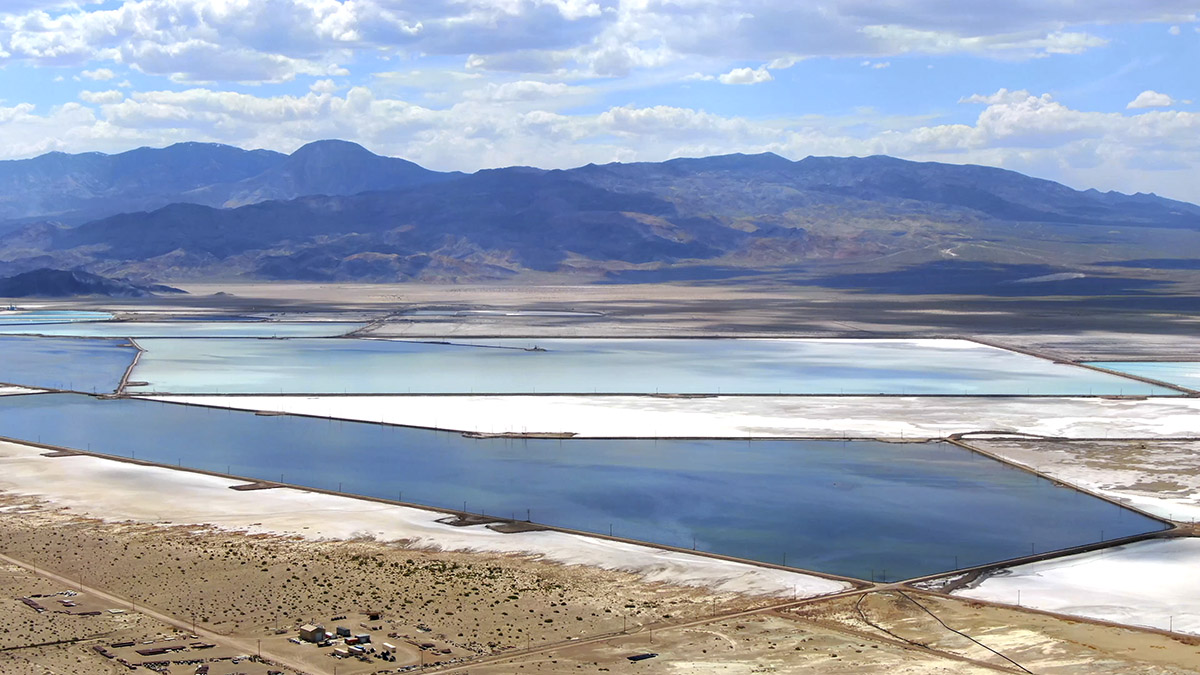
Aerial photograph of evaporative lithium ponds at Silver Peak Nevada. Photo by Robert Marcos.
By Robert Marcos, photojournalist
A study conducted by Jennifer Dunn – a professor of chemical and biological engineering at the Center for Engineering Sustainability and Resilience at Northwestern University in Illinois, said that the future of water availability may constrain whether new lithium mines will have sufficient water to operate.2
Three lithium operations in the American West that could be negatively affected by water restrictions –
Silver Peak, Nevada
Silver Peak – which is operated by Albemarle Corporation, is the only active producing lithium mine in the United States. Silver Peak uses evaporative technology that pumps lithium-rich geothermal brine from underground aquifers into a massive network of shallow, open-air surface ponds, where natural solar energy slowly evaporates the water which concentrates the dissolved lithium, which is later processed. The site has been in operation since the 1960s. Albemarle, which acquired the mine in 2015, has begun an expansion which will drastically increase their domestic production capabilities.3 Because Silver Peak’s extraction process relies on pumping billions of gallons of underground brine into solar evaporation ponds, a reduced amount of groundwater directly affects production capacity. The ongoing depletion has dried up local monitoring wells, sparking intense pushback from environmental groups, county officials, and competing mining projects.4
Salton Sea, California
Controlled Thermal Resources is developing the Hell’s Kitchen project at California’s Salton Sea, an innovative facility designed to utilize direct lithium extraction to recover battery-grade lithium from superheated geothermal brines while simultaneously generating clean, baseload electricity.5 Unfortunately this high-technology process still requires a lot of fresh water. It requires billions of gallons of freshwater primarily for evaporative cooling to manage the extreme temperatures of the geothermal fluids, and for purification and chemical washing to scrub impurities like iron and manganese from the extracted lithium. Additionally, massive amounts of freshwater are consumed during steam generation and the final chemical transformation needed to synthesize the lithium into a highly pure, battery-grade lithium hydroxide product.6
Thacker Pass, Nevada
The Thacker Pass mining operation is located in Humboldt County, Nevada. It’s owned by a joint venture between Lithium Americas (62%) and General Motors (38%).7 The facility will extract lithium via open-pit “hard rock” mining and will then process the claystone ore using a sulfuric acid leaching method, in order to produce battery-grade lithium carbonate.8 Fresh water is required at multiple opertional stages, though the Lithium Americas project has plans to recycle over 85% of the water that’s required, which includes:9
Ore Processing & Leaching: Water acts as a carrier for claystone ore and is consumed during sulfuric acid production, leaching, and downstream neutralization to isolate lithium carbonate. 10
Evaporative Cooling: Significant quantities of water evaporate during the cooling phases of chemical processing and on-site power generation. 11
Dust Mitigation: Water is continuously sprayed on open-pit mining roads, ore stockpiles, and waste piles to suppress hazardous dust. 12
Tailings Management: While filter presses squeeze out water for reuse, a portion of water remains permanently trapped as moisture within the dry-stack tailings pile. 13
The Thacker Pass operation’s difficulty in securing fresh water stems from a series of high-stakes legal and logistical disputes regarding regional groundwater depletion. The mine’s plans to extract up to 5,200 acre-feet of water annually draw from the heavily over-allocated Quinn River Valley aquifer, prompting multi-year legal challenges from environmentalists, Indigenous groups, and local senior water rights holders like rancher Edward Bartell, (who documented declining natural spring levels) and successfully triggered a state-issued cease-and-desist order that temporarily halted unauthorized pumping in mid-2025. While Lithium Americas ultimately bypassed immediate pumping blocks by purchasing Bartell’s water rights in an August 2025 court-approved settlement and securing a favorable Nevada Supreme Court ruling in 2026, state regulatory restrictions still forbid them from drawing water close to the mine site. Consequently, the company has faced soaring infrastructural challenges, forcing them to construct a costly, 8-mile-long uphill pipeline to transport their newly relocated water supply from the valley basin up to the active construction site. 14
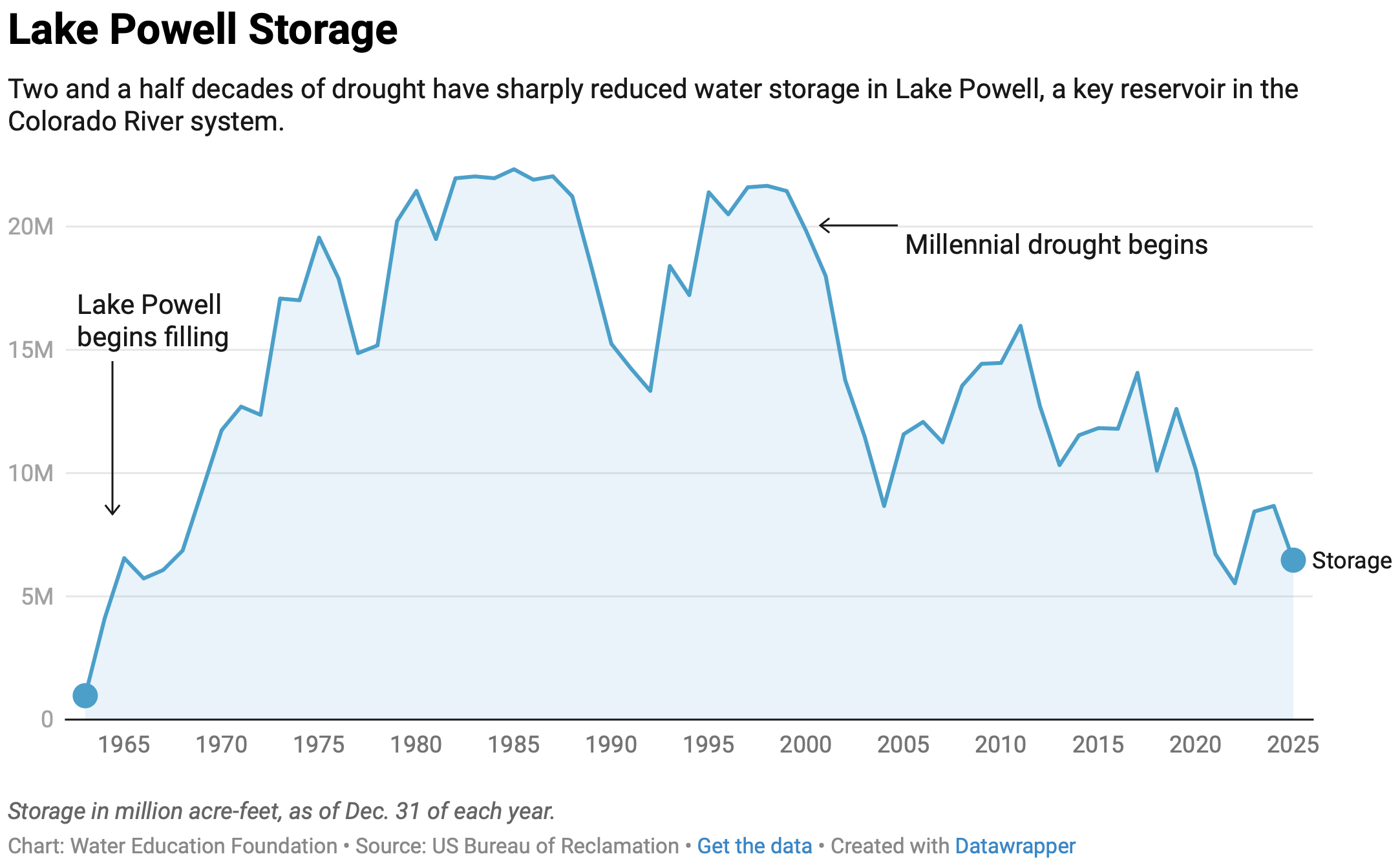
Glen Canyon Dam and Lake Powell, one of the nation’s largest-capacity reservoirs whose operation has been a point of contention between the Upper and Lower Basins of the Colorado River. (Alexander Heilner, The Water Desk)
Western Water In-depth: A ‘wild idea’ to defuse the colorado river compact’s legal time bomb has been kept alive by seasoned observers who believe it could still save the river
For the past 20 years, the Colorado River has been operated under a set of guidelines negotiated between the seven states that depend on the river. Those guidelines expire this year, and after five years of grinding negotiations over a new agreement, the upstream states of Colorado, Wyoming, Utah and New Mexico remain deadlocked against the downstream states of California, Arizona and Nevada.
Some 40 million people and 5.5 million acres of farmland depend on the river’s water. But after the states failed to meet two federal deadlines in three months, the river is in a moment of unprecedented crisis. A dire snowpack has left flows just 15 percent of normal, many farms without water and several cities scrambling to secure water supplies as they gird themselves for shortages.
That has set up a showdown over a legal time bomb that’s been ticking away at the heart of the Colorado River Compact since the river’s guiding document was signed more than 100 years ago. The Lower Basin states believe the Compact promised them a minimum delivery of water sent down the river from the Upper Basin. The Upper Basin states believe the Compact promised them a fixed amount of water that they could rely on to meet future growth. As the river’s flows have dwindled, those two supposed guarantees are proving to be irreconcilable.
Experts have seen the showdown coming for a long time, but climate change has accelerated the day of reckoning. In 2000, a drought sunk its teeth into the river and hasn’t let up. Dubbed the Millennium Drought, it is now recognized as one of the worst droughts on the river in more than 1,200 years — and may actually be the beginning of a long-term shift to a drier reality.
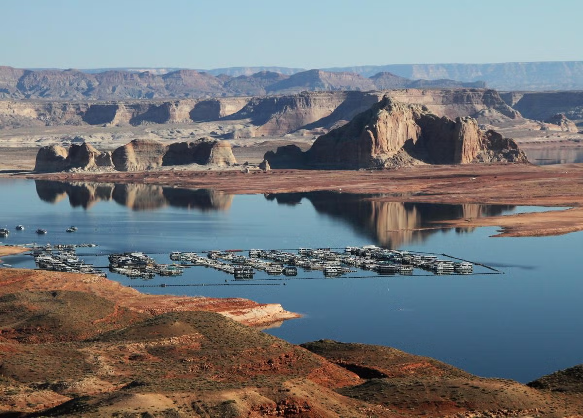
Despite near-endless negotiations to find a way to keep the river’s massive reservoir system from crashing — an effort that began over two decades ago — the drought may have finally pushed the Colorado River Compact to its limit. Now, the system is nearly empty and runoff from this winter’s snowpack, the source of any water that might offer even a small hope of relief, will be among the lowest since Glen Canyon Dam was built near the Arizona-Utah border, creating Lake Powell, more than 60 years ago. Flows in the river are perilously close to hitting the primary legal “tripwire” in the Compact. Once that’s crossed, the Lower Basin states would likely try to force the Upper Basin to deliver their water apportionment downstream — a prospect long considered unthinkable.
“All those negotiations helped push the day of reckoning back further, and helped delay the inevitable,” says Doug Kenney, who heads the University of Colorado’s Western Water Policy Program. “But at some point, you just have to acknowledge the fact that the numbers don’t add up and you’re going to have to deal with it. We’re at that point.”
Two obvious paths now lie ahead. One is a courtroom fight, either against the U.S. Secretary of the Interior or a challenge between two states under the terms of the Colorado River Compact, which would go directly before the Supreme Court. A high court case would be a doomsday scenario, a messy and protracted legal battle that, until now, the seven states desperately sought to avoid. The other potential path is a stopgap fix, a short-term interim plan negotiated between the states or imposed by the Interior secretary. That could, at least temporarily, forestall a trip to court, but it wouldn’t resolve the fundamental conflict.
For more than two decades, however, the possibility of a third path has stubbornly persisted in the background: A “grand bargain,” an idea first proposed in 2005 by Colorado’s negotiating team early in the effort to grapple with the worsening drought. The concept was an unorthodox bid to defuse the ticking time bomb — but it would require each basin to trade away its most cherished claim on the river.
‘A WILD IDEA’
Roughly 90 percent of the Colorado River’s flow originates as snowpack in the Rocky Mountains. One of the principal goals of the 1922 Compact, which is essentially a seven-state treaty, was to avoid future legal battles by creating an “equitable division and apportionment” of water between the Upper Basin states in the river’s headwaters and the faster-growing Lower Basin. The Compact apportioned 7.5 million acre-feet a year from the mainstem of the river to each basin. (An acre-foot is 325,851 gallons, enough to supply the average annual needs of roughly 3 households, depending on their location and climate.)
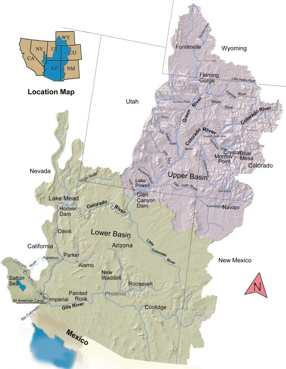
The Colorado River Basin spans seven U.S. states and is divided into Upper and Lower Basins. Lake Powell, upstream from the Grand Canyon, and Lake Mead, near Las Vegas, are the two principal reservoirs in the Colorado River water-supply system. (Bureau of Reclamation)
The Compact also contains a requirement that the headwaters states not deplete the flow of the river below 75 million acre-feet, plus another roughly 7.5 million acre-feet (half of the apportionment earmarked for Mexico), on a 10-year running average. Those provisions were intended to provide surety to the downstream Lower Basin states that they would receive their 7.5 million-acre-foot annual apportionment and that the basins would share equally in the Mexican obligation. If the 10-year running average requirement is violated, the Lower Basin states could — at least in theory — initiate a Compact “call” against the Upper Basin in an attempt to force the headwaters states to deliver more water downstream.
For roughly 80 years after the Compact was signed, the prospect of a Compact call was purely theoretical. Then the Millennium Drought set in. By 2005, the two flagship reservoirs on the Colorado River — Lakes Mead and Powell — were half empty.
The drought was pushing the river’s flows closer to a Compact violation trigger, making the risk of a call by the Lower Basin a growing probability. The Lower Basin, particularly Arizona, was insisting on guaranteed releases of water from Lake Powell. And because Colorado has the biggest share of the river within the Upper Basin and uses a greater portion of its apportionment than the other upstream states, it is most at risk. It began searching for a way to slip out of the legal noose of a Compact call.
In September 2005, the seven states’ top negotiators met in Albuquerque, New Mexico. During a lunch break, Colorado’s team made its pitch. The state’s negotiators proposed that the Lower Basin waive its right to force a downstream delivery through a Compact call. In exchange, the Upper Basin states would limit their water use to less than what’s strictly apportioned in the Compact, thereby reducing potential demand in the headwaters of Colorado and Wyoming that supply nearly the entirety of the river’s flow.
The offer was essentially a simplification and reframing of a dizzying array of technical disagreements over various provisions of the Compact — an attempt to throw spaghetti at the wall to see if it would stick.
Jim Lochhead, who had previously been Colorado’s top negotiator and in 2005 was serving as a legal advisor on the state’s team.
“My recollection was that it was a pretty spontaneous proposal,” says Jim Lochhead, who had previously been Colorado’s top negotiator and in 2005 was continuing to serve as a legal advisor on the state’s team. “We weren’t making any progress, and it was pitched as, ‘If you really want to cut through all of this and get to the bottom, here’s a wild idea.’”
The proposal sparked discussion among all the parties at the negotiating table but also raised difficult issues.
“It was a great concept on paper,” says Pat Mulroy, who was the head of the Southern Nevada Water Authority and Nevada’s principal negotiator at the time. “Whether it was politically doable or not is a whole other ball game.”
In large part, that’s because a grand bargain would have forced both basins to give up assurances in the Compact that they consider sacrosanct.
“I’m not sure the Upper Basin would ever have agreed to limiting their ability to fully develop their 7.5. It’s like giving up your birthright — I’m not sure they could have sold that at home,” says Mulroy. Conversely, she says, “giving up that call provision is really the only weapon the Lower Basin has.”
And, indeed, following its spontaneous birth in Albuquerque, the proposal ran into stiff political headwinds back home in Colorado, where it failed to get then-governor Bill Owens’ blessing.
“I wasn’t directly representing the state of Colorado at that time; I was representing Colorado water users,” Lochhead says. “And when I brought the idea back to the state, it pretty quickly got shot down: ‘No, we can’t agree to anything that would not keep the dream alive of 7.5 million acre-feet being developed in the Upper Basin.’”
The prospect of a grand bargain itself faded from discussion. And yet, in ways that aren’t often acknowledged, it continued to shape the broad contours of the negotiations that unfolded over the next two decades.
The quest to escape the noose of a Compact call has remained central to Colorado’s bargaining position.
“The concept of a waiver of a Compact call is alive and well,” says Anne Castle, a former assistant Interior secretary who is now a senior fellow at the University of Colorado. “The quid pro quo for that waiver has taken different forms.”
To a large extent, the details of the various offers the Lower Basin has made in exchange for a possible waiver — which have sometimes been characterized within the negotiations as “mini grand bargains” — have never become public. What is clear is that the two basins have consistently failed to cut a deal.
Instead, the seven states adopted a more incremental approach, negotiating a series of drought-protection agreements based on smaller, more politically palatable deals. While that’s been a safer path for everyone politically, it has brought other kinds of risk.
“It just added layer upon layer of Gorilla Glue and Band-Aids that’s made it much more complicated to try to unwind or develop new agreements,” Lochhead says, “and has obviously proven to be inadequate in protecting the system.”
A SECOND LIFE
While the concept of a grand bargain led a short life at the negotiating table, it has gone on to live a remarkable second life. The idea was picked up and revived by a loose-knit group of seasoned observers of Colorado River issues who, for years, have called for more durable alternatives to the patchwork of ideas [ed. “The Law of the River”] in play among negotiators.
Eric Kuhn was a member of Colorado’s negotiating team when the grand bargain was proposed in 2005. At the time, he was the general manager of the Colorado River Water Conservation District based in Glenwood Springs and he has written thoughtfully and voluminously about the river’s problems. After his retirement in 2018, he partnered with John Fleck, a former journalist who is now author-in-residence at the University of New Mexico’s Utton Center, to write Science Be Dammed: How Ignoring Inconvenient Science Drained the Colorado River.
Kuhn and Fleck concluded the book by observing that “there is not enough water in the Colorado River for all the lawyers to be right,” and suggested the grand bargain as a way to avoid the courtroom.
“The basic idea of a grand bargain is, in lieu of litigation, we’re going to agree to something that both sides want,” says Kuhn.
He and Fleck weren’t the only ones who pushed for more serious consideration of the idea. Doug Kenney at the University of Colorado also has championed the concept. In 2012, he enlisted Kevin Wheeler, a widely respected engineer and fellow at Oxford University, to undertake modeling analysis of the kinds of trade-offs a grand bargain might require.
Persistent drought has lowered Lake Powell’s water level and exposed land that was once submerged at Wahweap Marina, as seen in this 2022 photo. (Bureau of Reclamation)
In 2021, Wheeler — together with a group of collaborators including Kuhn, climate scientist Brad Udall and Jack Schmidt, the director of Utah State’s Center for Colorado River Studies — published a white paper called “Alternative Management Paradigms for the Future of the Colorado and Green Rivers.” It was a comprehensive assessment of more ambitious strategies for weathering the drought and climate change than had emerged from now-perpetual negotiations between the states.
“New approaches that are responsive to significantly drier climate conditions and changing patterns of consumptive uses may require bolder policy initiatives that exceed the incremental approach of modern management,” the group wrote. “It is critical to explore alternative water management strategies that may extend beyond the framework of the Law of the River as presently interpreted.”
The following year, the team published a paper in the journal Science titled “What Will it Take to Stabilize the Colorado River?” And, it turned out, stabilizing the system would take something that looked a lot like a grand bargain.
Assuming the drought persists as it has since 2000, Wheeler and his partners identified two scenarios that would stabilize the river, both of which assumed the Lower Basin had waived its ability to make a Compact call. In one, the Lower Basin would need to decrease its water use by about 2 million acre-feet a year when Lake Mead and Lake Powell reach low levels. That would assure it of about 78 percent of its apportionment — an amount roughly in line with cuts it has already committed to taking. In exchange, the Upper Basin would have to cap its water use at 4 million acre-feet. But that’s only slightly more than half of its 7.5 million-acre-foot Compact apportionment, and roughly 300,000 acre-feet less than what it currently uses.
The second scenario — call it the “near-parity scenario” for simplicity — more equally distributed the Upper and Lower Basins’ relative cuts in apportionment. In it, the Upper Basin would cap its use at 4.5 million acre-feet, leaving it with 60 percent of its Compact apportionment. The Lower Basin would be able to use about 67 percent of its Compact apportionment when reservoirs are low, just slightly more percentage-wise than the Upper Basin. But it would have to cut its uses by 3 million acre-feet below its apportionment.
That would stabilize the system — or at least go a long way toward doing so — while largely meeting existing water demands in both basins. The Upper Basin currently uses about 4.3 million acre-feet per year. The Lower Basin, after ramping up an aggressive water conservation effort since 2007, has driven its annual use down to about 6 million acre-feet per year, and has signaled that it could likely reduce demand further.
But it would leave practically no leeway for future growth, at least without reshaping the socioeconomic landscape across the entire Basin. In particular, any future urban growth could come only by shifting significant amounts of water from farms to cities.
HARD MATH
Today, there is a simple, hard reality on the Colorado River: The available water supply is already maxed out. Water use throughout the basin needs to be reduced by roughly 25 percent just to make the numbers work now — to say nothing of the future, which is likely to be significantly drier.
In Colorado, that has raised hard questions about fairness, the “equitable division and apportionment” provision of the Compact, and the assurance the state thought it had that its water would be there to develop when it’s finally ready.
“Everyone agrees that there should be an equitable division of water, and the word ‘equity’ is one that everyone will rally around,” says Kenney. “But does equitable mean equal? That’s the crux of the issue.”
Over the past several years, Colorado’s attorney general, Phil Weiser, has been building his office’s staff of water lawyers. This January, Weiser, who is currently running for governor, appeared before a joint hearing of the state legislature’s judiciary committees.
“If we can’t get a deal — and I’m committed to not getting a bad deal just to get a deal — we’ll be in litigation. We’re ready for it,” he said. “If and when we can get a reasonable deal based in reality, I’m for it. But if we can’t, then we will be falling back on our rights under (the) 1922 Compact.”
Because of the peculiarities of the water-rights hierarchy in the Lower Basin, Arizona is arguably most at risk there. In March, that state — whose governor, Katie Hobbs, is running for re-election — retained the high-powered law firm Sullivan & Cromwell to represent it in potential Colorado River litigation. At the time, a spokesman for the governor said, “it’s critical that Arizona be prepared to defend ourselves in court if an agreement cannot be reached or the Law of the River is violated.”
Anne Castle, a veteran of Colorado River issues. Former U.S. Commissioner, Upper Colorado River Commission • Former Assistant Secretary for Water and Science, U.S. Department of the Interior. (Source: Water Education Foundation)
“It is very difficult for a political figure — and they’re all political figures, even if they’re not elected — to agree to reduce the water use of their constituents and keep their career alive,” says Anne Castle. “They have to be able to tell their constituents, ‘I’m fighting for your water. I’m doing everything I can to keep your water secure, and it’s the other guy’s fault.’ The political incentives are directly at odds with the kind of compromise that’s needed in this type of hydrologic situation.”
Following the breakdown in negotiations between the Colorado River states, the federal government has announced its intention to step in. In May, the Bureau of Reclamation, on behalf of the Department of the Interior, revealed that it is preparing the first of what could be a series of five two-year interim plans for the river.
The final details are expected to be released this summer. But the federal government has indicated that the Interior secretary could cut water deliveries to the Lower Basin states by up to 3 million acre-feet — 40 percent of their Compact apportionment. During a briefing for Arizona water users in May, Brenda Burman, the head of the Central Arizona Project, presented modeling analysis of the proposed reductions and noted that, given the diminished releases from Lake Powell, the Upper Basin is “in a definite breach of the Compact by Sept. 30 of 2026.”
Owing to some quirks of river history, the secretary debatably has less authority in the Upper Basin, and so Reclamation has proposed no cuts there. But as climate change continues to eat away at snowpack and river flows, the Upper Basin states will likely be forced to cut back their uses anyway. Regardless of what the Compact says the Upper Basin gets, the water simply won’t be there.
And so now the seven states are facing a situation eerily similar to those in the near-parity scenario Wheeler and his colleagues laid out in their Science paper four years ago — but without a bargain.
COMING FULL CIRCLE?
In many ways, the prospects have never been worse for something like a grand bargain. Yet the fundamental problems the grand bargain was intended to solve have only grown sharper in the 20 years since it was first proposed.
“The grand bargain has gotten a bad name,” Kuhn says. “But if these issues aren’t resolved through a grand bargain, they’re going to be resolved through litigation.” In 2007, he says, the river’s reservoirs still had ample water to work with. “With empty reservoirs, you cannot finesse these issues.”
Glen Canyon Dam creates water storage on the Colorado River in Lake Powell. Credit: U.S. Bureau of Reclamation
Litigation could come as soon as August, when Reclamation will likely release a record of decision for its proposed new operating plan. Legal action could take one of several paths. The one with the highest stakes would be direct enforcement of the Compact, likely in the form of a Compact call brought by Arizona and the other Lower Basin states against the Upper Basin states. Because the Compact is essentially a treaty between multiple states, that would go directly before the Supreme Court. But such cases are often grindingly long: Arizona’s 1952 lawsuit against California over Colorado River rights took a dozen years to resolve. A case in the Supreme Court could put the river in protracted litigation during a time of profound crisis.
Other, more limited challenges are possible, most likely against the Bureau of Reclamation or the secretary of the Interior for failure to comply with the Compact or violating environmental laws. But they, too, are not without risk.
“I have a hard time believing you could keep litigation contained, once that genie’s out of the bottle,” says Kenney. “I just have to believe that inevitably blows up into a full-fledged interstate litigation and it bumping right up to the Supreme Court.”
As the odds rise of a legal challenge to the Compact that could ultimately wind up before the highest court in the land, the fundamental tension the grand bargain was intended to resolve will likely be front and center before the justices. And, paradoxically, that could force the states themselves to finally make the really tough sacrifices they’ve been trying to avoid.
“I think that a road to a grand bargain runs through litigation,” says Kuhn.
That’s because in past interstate fights over shared rivers, the Supreme Court has typically appointed a water-law expert known as a special master to referee such cases. The most recent example is the dispute between Texas, New Mexico and Colorado over the Rio Grande. In that case, Kuhn notes, “the special master said, ‘You don’t want me or the court to decide this; get in a room and negotiate it.’ The special master kept the pressure on the states to negotiate.”
This May, the Supreme Court approved a settlement between those three states. Still, even that resolution only came a full 13 years after the case was initially filed, and it involves relatively small reductions in overall water use.
On the Colorado River, both water and time are in far shorter supply.
Western Water, our flagship publication by Foundation journalists, is available online. Check out our latest articles. Reach writer Matt Jenkins at mjenkins@watereducation.org.
Know someone who wants to stay connected to water in the West? Encourage them to sign up for Western Water and follow us on LinkedInand Instagram.
Colorado River “Beginnings”. Photo: Brent Gardner-Smith/Aspen Journalism
Last post here, I suggested that at least some of the ongoing failure of the seven Colorado River states to reach agreement on a river management plan for even the next several years, let alone new century, stems from some ‘elephants in the river.’ You know – the big things that nobody wants to look at because they are so big. So big that some of the rules and guidelines we operate under were created to avoid having to address them.
The first ‘elephant in the river’ I discussed last time was the single-minded focus on the Colorado’s surface waters, and a failure to begin considering the whole integrated water supply, surface water and groundwater – of which the surface water is a relatively minor part, with users going to the groundwater in a haphazard way when the surface water is insufficient.
I did make an incorrect statement in that analysis, however. I said that Colorado was the first, and thus far only, state to begin integrating groundwater into its appropriation priority system statewide. (Arizona developed – by federal mandate – a Groundwater Management Plan circa 1970 for those specific parts of the state served by the Central Arizona Project.)
This is true about Colorado – but I was mistaken in implying that the all groundwater use was integrated into its appropriation system by 1969 legislation. Only alluvial groundwater is covered by that law – groundwater that is naturally integrated with surface water, either trickling into the surface streams when the groundwater table is high or drawing riparian water from the surface streams when the water table is low.
Not covered by the Colorado law are ‘non-tributary’ aquifers that have no natural interaction with the surface waters – aquifers like the Oglalla Aquifer in eastern Colorado, or the Denver Basin aquifer. Most of their water filters down from the alluvial groundwater, and only modern pumping technology makes that groundwater accessible to surface use. Most of these deep aquifers have accumulated their water slowly over geological periods of time, and even moderate use of their water dips quickly into ‘water-mining.’ Colorado law for such aquifers attempts to limit annual use to a hundredth of a presumed 100-year supply, but no one knows for sure how much water is really down there, or whether it will truly constitute a 100-year supply.
The standard response throughout much of the basin to shortages in surface water is to go to groundwater pumping; if ‘tributary’ (alluvial) groundwater is tapped, the pumping will gradually lower the water table – which in turn will begin to diminish the surface streams, which in turn will increase the pumping – et cetera, a vicious downward cycle. And the pumping of ‘non-tributary’ aquifers is largely unregulated in the basin.
At any rate – apologies for the error, and thanks to John McClow for pointing it out.
And on to another elephant in the room. Is it finally time to determine limits on the presumed universal applicability of the appropriation doctrine? To avoid being shot before I finish the paragraph, I will say immediately I am not suggesting doing away with the appropriation doctrine; it is a good enough last resort down on the ground where the appropriation doctrine started, for working out local problems of water use on a surface stream when neighborliness fails – that is, when old grumps and feuds preclude the ‘gentlemen’s agreement’ on sharing out what water is available, rather than shutting down the junior users with a ‘call’ so the seniors can get all their decreed water. After two or three generations, seniority can be acknowledged, but is too abstract to apply against your neighbors, if a plan for sharing blameless misfortune can be worked out.
The abstraction, however, becomes more applicable when it is distant water organizations calling out other water organizations upstream, or an earlier developed watershed placing a call on users in an adjacent more recently developed watershed. And when a stream is declared by the district engineer to be over-appropriated – not enough water to fill everyone’s decrees in a near-average year – it becomes even more abstract, a tool for enforcing a status quo, and nothing anywhere about what represents the best uses of the water.
There are, in other words, some areas in which the appropriation doctrine gets stretched beyond its elastic limits by emerging challenges of water use; any questions about ‘best and highest use’ have been essentially declared unanswerable as a matter of conflicting values, and it just seems easier to let seniority of use be the ultimate determinant of priorities.
A century ago, with California quintupling its population in the first two decades of the 20th century, the other six of the seven states in the Colorado River Basin (Arizona, Nevada, Colorado, New Mexico, Utah and Wyoming) began to worry that California might put so much of the river’s water to use that there would not be enough unappropriated water for them to put to use when their time of growth came. They were all committed to versions of the appropriation doctrine within their states, but came to believe that reliance on the appropriation doctrine alone at the interstate level could cause more regional problems than it would resolve.
That concern was affirmed in 1922 when the U.S. Supreme Court resolved a conflict between Colorado and Wyoming over a Laramie River tributary that started in Colorado but was put to use first in Wyoming; the court declared that states who used the appropriation doctrine intrastate would also have to respect each other’s appropriations interstate. This made real the specter of slow-growing upstream states having to let all their Colorado River water go downstream to fill huge Arizona and California decrees.
So they assembled in 1922 to try to do something about that – a fundamental fact about the Colorado River Compact commission that we tend to forget: the original intent of the compact commissioners in 1922 was to develop an alternative to the appropriations doctrine at the interstate level. They came together with the intent of working out a seven-way division of the use of the river, based on possible future development, that would eliminate a horse-race of interstate appropriative competition. Six of the states convened the commission because they feared California, and California reluctantly participated because it knew the feds would never build the big control and storage dam they needed until all seven states were on board with it. That seven-way division trumping interstate appropriation was what the Compact Commissioners assembled to do –and spent a frustrating week early in 1922 trying to do.
They were unable to effect a seven-way split for a couple of reasons: for one thing they had no good measure of how much dependable water was in the river; estimates at the time ranged from 12 to 20 million acre-feet (maf). But for a second thing, the sum total of the water they each felt their state needed, based on rosy early-20th-century estimates, was closer to 24 maf – and nobody wanted to go home having backed down from their carefully imagined numbers.
Members of the Colorado River Commission, in Santa Fe in 1922, after signing the Colorado River Compact. From left, W. S. Norviel (Arizona), Delph E. Carpenter (Colorado), Herbert Hoover (Secretary of Commerce and Chairman of Commission), R. E. Caldwell (Utah), Clarence C. Stetson (Executive Secretary of Commission), Stephen B. Davis, Jr. (New Mexico), Frank C. Emerson (Wyoming), W. F. McClure (California), and James G. Scrugham (Nevada). CREDIT: COLORADO STATE UNIVERSITY WATER RESOURCES ARCHIVE via Aspen Journalism
What they did instead – in order to persuade Congress that there was general agreement – was to cobble together the Compact we are burdened with today; they created what Commission Chair Herbert Hoover called a ‘temporary equitable division’ of the seven states into Upper and Lower River Basins, until ‘ those men who may come after us, possessed of a far greater fund of information’ could do the ‘further division’ of the river among the states.
They also decided – as early 20th-century Americans would – to lean toward the more optimistic estimates of river flow, dividing ‘equally’ between the Basins only 15 maf of a river they presumed would continue running 16-20 maf – hence the 7.5 maf for each Basin written into the compact, to be further divided among the states of each Basin in their own good time. That left some water for Mexico, but they did nothing specific for the Indian tribes in the basins because national Indian policy at that time was ‘soft genocide’ – full assimilation (‘kill the Indian, save the man’), leaving tribal water a concern they thought would disappear.
This all made reasonable sense with a river running a quarter-century average of just under 18 maf – but then through the 1930s the river experienced a drought unsurpassed until the past quarter century. By the end of World War II, Colorado river water users had a ‘far greater fund of information’ about the river’s flow, which would have made it a good time to have ‘fixed’ the Compact – but the growing fund of information was all bad news that no one wanted to incorporate into a more realistic policy. So by default the ‘temporary equitable division,’ with its mythic 18 maf river, took on the permanence of something carried off a sacred mountain carved in stone.
And now – we are seeing it reduced to a sad irony. The states of the Lower Basin had their fears too, and wanted a clause in the Compact stating that, should the Upper Basin states have a wild spurt of growth, they should not ‘deplete the flow’ to the Lower Basin below an average of 7.5 maf a year. But now – when it looks like diminished flows throughout the basin might really drop the flow at the division point between basins below that average – the Lower Basin is threatening the Upper Basin with an Article III(d) ‘call,’ saying the upper states will have to cut their own uses enough to meet the lower states’ fantasy 7.5 maf. States that set out a century ago to create a compact that would transcend the appropriation doctrine at the interstate level are now trying to turn that ‘temporary equitable division’ into what amounts to a senior interstate water right.
There has to be a level, or category, of action in which the law of first-come first-served is transcended by other considerations. And can we not say, at this point a century later, that the original intention of the compact commission has been achieved de facto? No state will ever get the use of more water than it had (or believed it had) around the turn of the century because there is even less water now. For better or worse, the use of the river has been distributed among the states (including some of the tribes) and Mexico.
Udall/Overpeck 4-panel Figure Colorado River temperature/precipitation/natural flows with trend. Lake Mead and Lake Powell storage. Updated through Water Year 2025. Note the tiny points on the annual data so that you can flyspeck the individual years. Credit: Brad Udall
Whether this is an equitable division is arguable; the states of the Lower Basin have been using roughly two-thirds of the river’s water, the Upper Basin states around one third, rather than the 50-50 split explicit in the Compact (7.5 maf per Basin). But arguably that does reflect the relative productivity of Lower Basin agricultural use (by far the largest use) and also its millions of urbanites drawing on it for at least part of their municipal water. It was a huge step toward reality when the Lower Basin states finally agreed that they must absorb the Lower Basin’s system losses (mostly evapotranspiration) and their half of Mexico’s allotment out of their own shares of the river, rather than relying on a fictional surplus to cover it – a fiction that combined with drought to draw down both Powell and Mead Reservoirs to the dangerous level where they linger today.
Yampa River Basin via Wikimedia. Note the Little Snake River crossing the Colorado-Wyoming line.
The 1948 Upper Colorado River Compact was the first reality-based document in the ‘Law of River’ portfolio because its negotiators knew by then – that ‘greater fund of knowledge’ – that it was doubtful that there would always be 7.5 maf for their use, and actually accepted that as their reality. So the divided their ‘half’ of the river into percentages for each state of whatever was left for the upper states after the Lower Basin got it Boulder Canyon Project Act waters. After three-quarters of a century, the four states are not too far from those percentages in their development of around 4.5 maf; only Wyoming is significantly under its 13 percent; Utah is a little below its 23 percent; and Colorado is a little over its 51.75 percent. Given the geographic irrelevance of western state boundaries (the Little Snake River crosses the Colorado-Wyoming border half a dozen times), this was pretty good 1948 estimating.
The reality today is that all Colorado River water users in all seven basin states are using a finite and measurable resource that will probably continue to diminish for the foreseeable future as we continue to heat up the planet, and we need to come to an agreement on what that means for all users. [ed. emphasis mine]
It seems to me there are three ways to address that diminishing flow. One way is to continue to accept the divine sanctity of the Colorado River Compact, with the Upper Basin states forced by the Supremes (they ride for power, not for the law) to cut back their own uses to meet the 7.5 maf average delivery to the Lower Basin – basically the interstate nightmare (for the upper states) the Compact was meant to address. Call this the stubborn denial option.
A second way would be to accept the evolved eight-way division (seven states plus Mexico) of the use of the river’s water, which was what the seven states wanted to do in 1922, instead of the ‘temporary equitable’ compact they came up with. Percentages for each basin state could be set according to the amount each state was using at the end of the major river development era, say in Y2K (remember that?), when the 70-year average annual flow was ~14.5 maf (1930-2000). Those state percentages of the river’s consumptive use could be retained – but the actual volume of water for each state would gradually diminish as the combination of ‘dry drought’ and ‘heat drought’ continues to diminish the river. Given that losses attributable to climate warming are both everybody’s and nobody’s fault, the losses to each states would be proportionate to their percentage of the river’s consumptive use, with no falling back on seniority, as though it were just a squabble between users. Each state could then either stay with the appropriation doctrine intrastate with junior users bearing the loss, or equitably share out the loss proportionate to use. Call the latter the shared reality option.
Photo of Crowley County by Jennifer Goodland
A third way lies between stubborn denial and shared reality, and will probably prevail as the default American Way: let money work it out. Municipal and industrial users will continue to work out money-for-water deals with agricultural users, like San Diego and the Metropolitan Water District have done with the Palo Verde and Imperial Valley ag districts, with responsible districts using the money for systemic improvements that minimize the impact of lost water. This is by no means going to ‘dry up’ agriculture. With 75-85 percent of the river’s water being used by agriculture, a doubling of M&I use would only require transfer of 10-15 percent of ag water, although (money being blind to all but profitability) the transfers would probably cause some local tragedies like Crowley County in Colorado where too much water was bought out of a single small irrigation district by Front Range entrepreneurs.
The appropriation doctrine, with its strange ‘property right’ independent of the property for which it was granted, is quite compatible with the money option for resolving water distribution, once over-appropriation is achieved. The idea that water’s seniority in a certain use can be transferred to a totally different use along with the water strikes me as strange – shouldn’t a new use initiate a new right? It is also contradictory to the doctrine’s initial democratic-populist effort to prevent the dominance of big money in water distribution by limiting water rights to what one could put to use. But it does seem to be the American way that everything eventually comes down to money as the base determinant of value.
Enough for today. The elephants in the river. I obviously favor ‘ratifying’ the evolved split of the use of the river, and an equitable proportionate sharing among all states – and within all states – of the consequences of our cultural climate changes. But that will not fly among those who have steadfast faith (senior water right holders) in the appropriation doctrine as the answer to all problems.
The river? It abides, rises and falls with the water table in its surrounding groundwater, and it may occasionally disappear, but it won’t have died, it will just have gone underground until the water table rises again and the ground can’t hold all the water – if we figure out how to let that happen.
Map of the Colorado River drainage basin, created using USGS data. By Shannon1 Creative Commons Attribution-Share Alike 4.0