
Click the link to read the report (and drill down to the individual major basin stats) on the NRCS website. Here’s an excerpt:
Colorado experienced an unusual volatile winter this year. In October 2025 at the start of the water year; the southern basins received record amounts of rainfall, while the rest of the state saw minimal early-season accumulation. November brought intermittent storms but not enough to build a meaningful base and the snowpack remained well below normal. Early December finally delivered a measurable amount of snow for the northern basins but record high temperatures and lack of moisture in the middle of the month raised concerns heading into 2026. January continued the trend of minimal snow accumulations, and many basins began falling into single-digit percentiles. The first half of February remained dry, and although the second half brought some moisture it was not nearly enough to recover from the early-season deficit. Statewide snowpack entered March at 60 percent of median. March delivered a combination of record high temperatures and record low precipitation, causing some basins to reach peak snow-water-equivalent (SWE) almost a month early. The rate at which the snowpack began to melt was unprecedented, with soil moisture sensors and streamflow gages showing an immediate response. Thankfully, April brought cooler temperatures and above normal precipitation, allowing the remaining snowpack to linger a bit longer. With increased storm activity, the majority of hydrographs receded as runoff slowed down. However, by May 1st statewide snowpack had fallen to the zeroth percentile and the remaining snowpack continued to melt. Melt in May is common, but the combination of extremely low snow conditions and warm temperature triggered a second peak in the hydrographs – a peak that normally would represent the first rise of the season. At nearly all streamflow forecast points the runoff duration was significantly shortened, as much of the volume had already been observed in March. By June 1st 91% of SNOTEL stations were fully melted out – compared to the typical 56% for this time of year, highlighting the exceptionally early and accelerated melt season.
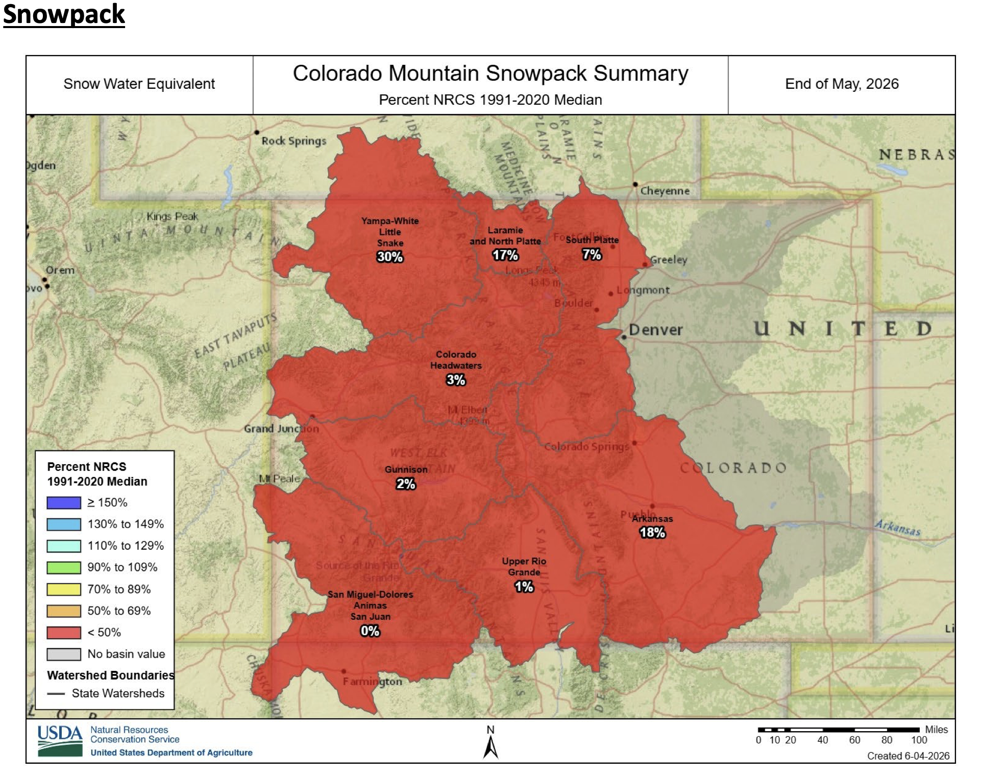
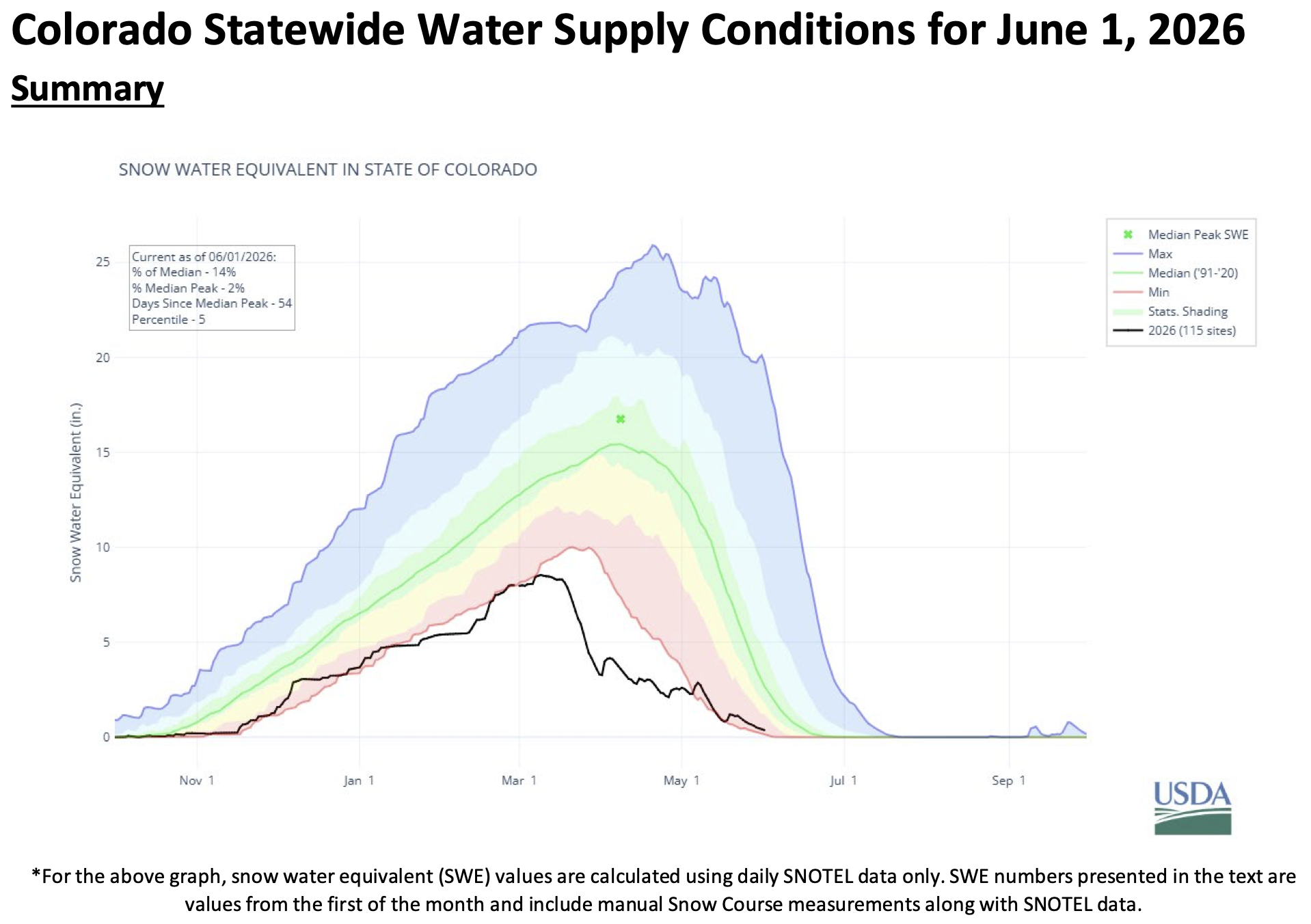
Statewide snowpack was 14 percent of the historical median as of June 1, with an average of 0.4 inches of snow water equivalent (SWE) in the state. This is the third-lowest June snowpack in the NRCS Snow Survey period of record, surpassed only by 2002 and 2012—years which both contained a higher seasonal SWE peak in mid-March but experienced rapid meltout in early April and May. Comparatively, 2026 experienced a record-breaking early initiation o snowpack melt in mid-March, reducing the total snowpack by half before cooler conditions and late-season snowfall hastened the decline throughout April. Snowpack melting returned to a predictable bell-curve pattern in May and at the end of the month all river basins currently exhibit far lower-than-median SWE in the state. The San Miguel-Dolores-Animas-San Juan, Upper Rio Grande, Gunnison, Colorado Headwaters, and South Platte exhibit the most extreme deviations from the 1991-2020 historical median, reporting 0, 1, 2, 3, and 7 percent of median snowpack SWE respectively. Meanwhile the Laramie-North Platte, Arkansas, and Yampa-White-Little Snake have low but less extreme deviations from median snowpack levels, reporting 17, 18, and 30 percent of median SWE.

The statewide water year-to-date precipitation remains below normal at 77 percent of median. May brought some improvements, with statewide precipitation at 104 percent of median, but the spatial distribution varied greatly. The front range and northern part of the state received above median precipitation with the South Platte River basin at 138 percent and the Laramie-North Platte basin at 128 percent for the month of May; an encouraging shift that helped boost soil moisture and short-term streamflow potential. In contrast, the southwestern basins received below median with the combined San Miguel-Dolores-Animas-San Juan River basin and Gunnison River basin at 53 percent and 60 percent of median, respectively. A shift from last month, where those two basins received the most precipitation in April at 155 percent and 116 percent of median. Tower SNOTEL located in the Yampa-White-Little Snake River basin received the most precipitation in the month of May with 5.8 inches total; 2.2 inches falling in a single day (May 5th, 2026).
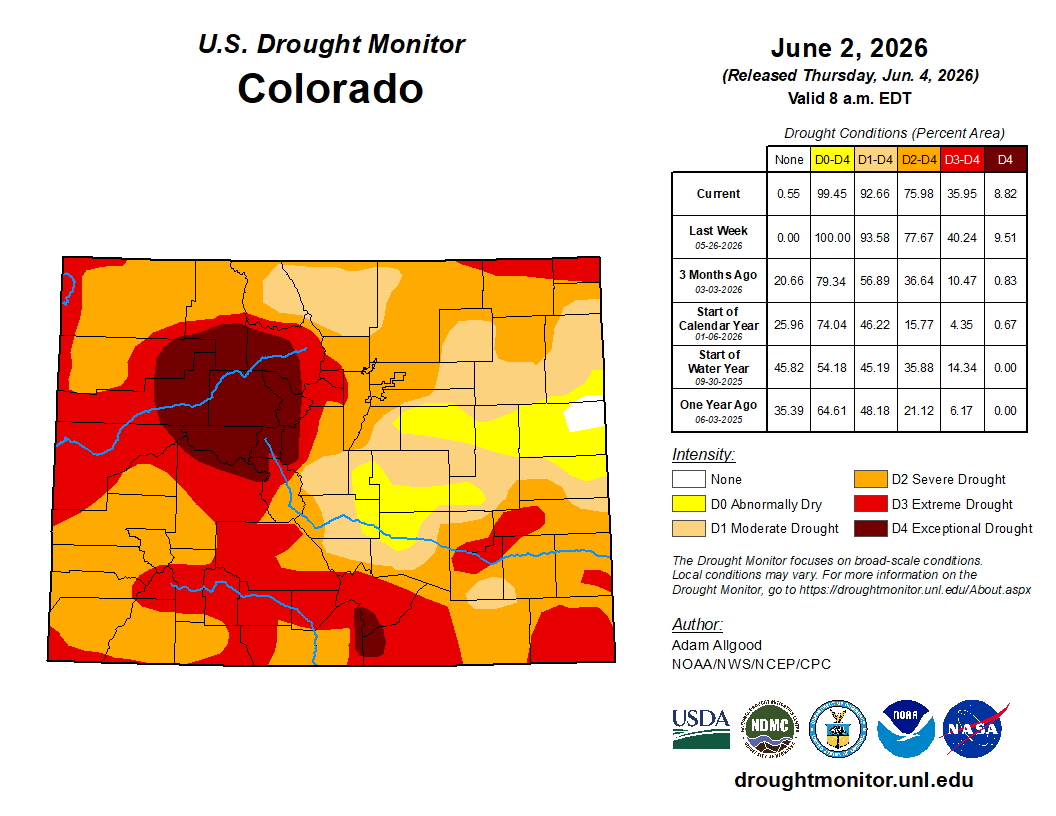
The current U.S. Drought Monitor Map shows drought conditions are still prevalent across the state, with slight improvements in some northern basins and slight degradations in the southern front range basins since last month. Spring moisture has brought some much-needed precipitation after a well-below normal winter. The monthly precipitation outlook from NOAA’s Climate Prediction Center forecasts above to near normal precipitation for the month of June.
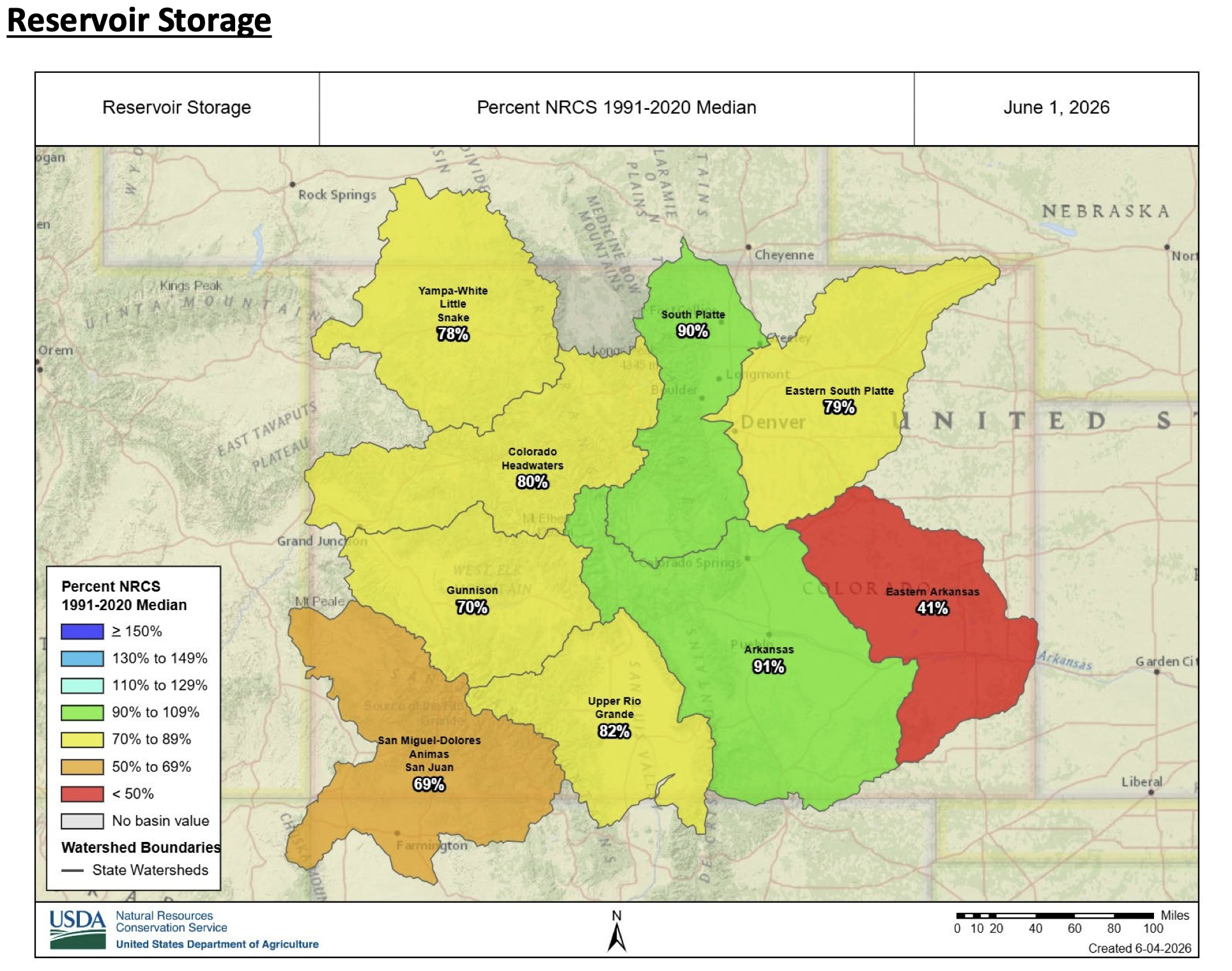
Reservoir storage is currently 75 percent of the 1991-2020 median on a state-wide scale, down from 85 percent last month. Mean water storage decreased in all river basins in the state compared to last month. As of June 1, storage remains relatively close to median in the Arkansas and South Platte*, reporting 91 and 90 percent median storage, respectively. The Upper Rio Grande, which had been an outlier with above-average reservoir storage since October 2025, is now down to 86 percent of median storage. Five additional basins are reporting reservoir storage levels somewhat below the 30-year median, with the Colorado Headwaters, Eastern South Platte, Yampa-White-Little Snake, Gunnison, and San Miguel-Dolores-Animas-San Juan reporting 80, 79, 78, 70, and 69 percent, respectively. The Eastern Arkansas remains the basin with the lowest overall percent of median storage, decreasing from 56 percent down to 41 percent of median storage this month. Overall, Colorado is currently utilizing 54 percent of total reservoir capacity statewide compared to 61 percent storage this time last year (see June 1 2026 Reservoir Storage Capacity chart).
*At the time of publishing, end-of-month reservoir water storage data had not yet been reported for 8 out of 23 reservoirs in the South Platte basin. These reservoirs were excluded (rather than reported zero) in the statistics above, and the data will be updated on our website as soon as it is available.

June through July forecasts at the 50 percent exceedance probability are at 24 percent of median statewide. Observed streamflow from March through May is 50 percent of median statewide. April and May alone are 41 percent as March runoff occurred outside the normal primary period. Record March temperatures drove an early rise in streamflow statewide weeks ahead of typical spring melt timing. Cooler April temperatures and increased April and early May storms placed a pause on snowmelt. A second rise in streamflow followed in mid-May consistent with normal sun angle-driven melt onset. May observed flows averaged 34 percent at a median percentile of 2. Those runoff conditions are observed downstream at Lake Powell where March through May observed inflow is 1,104,000 acre-feet at 28 percent of the period of record median ranking 3rd lowest in the 117-year record behind 2002 and 1977. June and July typically deliver 54 percent of the April through July volume at Powell. The June through July combined forecast is 300,000 acre-feet at 9 percent of median and is near 21 percent of projected total seasonal volume remaining. The forward-looking period 63 of 70 points rank at or below the 10th percentile with a median percentile of 3. Statewide remaining period volume at the 50 percent exceedance probability represents one third of projected total seasonal volume. May storm activity shaped a distribution where eastern basins retain comparatively more remaining volume. The South Platte is at 51 percent and Arkansas at 38 percent of median. Remaining snowpack is limited to the highest elevations and will contribute modestly to late-season flows. Above normal temperatures and above normal precipitation are both favored through the remaining period.