Click the link to read the article on The Land Desk website (Jonathan P. Thompson):
April 22, 2025
⛏️ Mining Monitor ⛏️
A little while back I wrote about Trump’s executive order aimed at making it easier to mine on federal lands. Now it’s becoming a little clearer how that might play out on the ground. The U.S. Permitting Council last week released a list of the first wave of mining projects the administration plans to fast track through the permitting process.
The projects include a few that the Land Desk has covered or mentioned in the past, such as:
- Lisbon Valley copper mine expansion.
- Hi-Tech’s McDermitt lithium exploration project in southern Oregon.
- Resolution Copper’s bid to mine a massive copper deposit under Chi’chil Biłdagoteel, aka Oak Flat, in central Arizona.
The announcement promised there are “many more projects on the way” to the expedited list, though it does not elaborate on what fast-tracking might look like, exactly. The council says it will publish permitting timetables for the projects by May 2. Stay tuned to the Land Desk for updates.
😀 Good News Corner 😎
Prizes, folks. There are prizes for the winners of the Land Desk’s Predict the (spring) Peak Super Contest! Why super? Because it’s not just for one stream, but for five. And that means there could be five winners, and each gets to choose one of these prizes from our merch selection.

Is that enticing, or what? But there is a bit of a catch: Only paid Land Desk subscribers will be eligible to enter the contest, meaning only they can win the prizes. But don’t fear: Sign up now and get 20% off the regular annual subscription price, and get the privilege of entering the Predict the Peak contest.
The idea is to accurately predict the spring runoff peak streamflow (in cubic feet per second) and the date of the peak for any or all of these five stream gages:
- Animas River in Durango, aka USGS gage 09361500.
- North Fork of the Gunnison River near Lazear, aka USGS gage 09136100.
- Rio Grande at Otowi Bridge, aka USGS gage 08313000.
- San Miguel River at Uravan, (extra credit for uranium readings!) aka USGS gage 09177000.
- Colorado River at the Utah-Colorado state line, aka USGS gage 09163500.
So an entry for the Animas might look like this: Animas River, May 17, 2,950 cubic-feet per-second. The winning entry would be the closest streamflow reading to the actual peak, with the date being a tie-breaker if needed. So if someone gets the cfs right, but the date wrong, they would beat out someone with the right date but wrong flow.
Entries will only be eligible if they are entered into the comment section below this post. Don’t email me your entries! They won’t count! (If you are a paid subscriber but are having problems commenting, let me know at landdesk@substack.com). And they must be entered before Friday, May 16, to be eligible. Winners will be determined after spring runoff has peaked on all of the rivers, which will likely be in late June or early July (or perhaps earlier if spring remains warm).
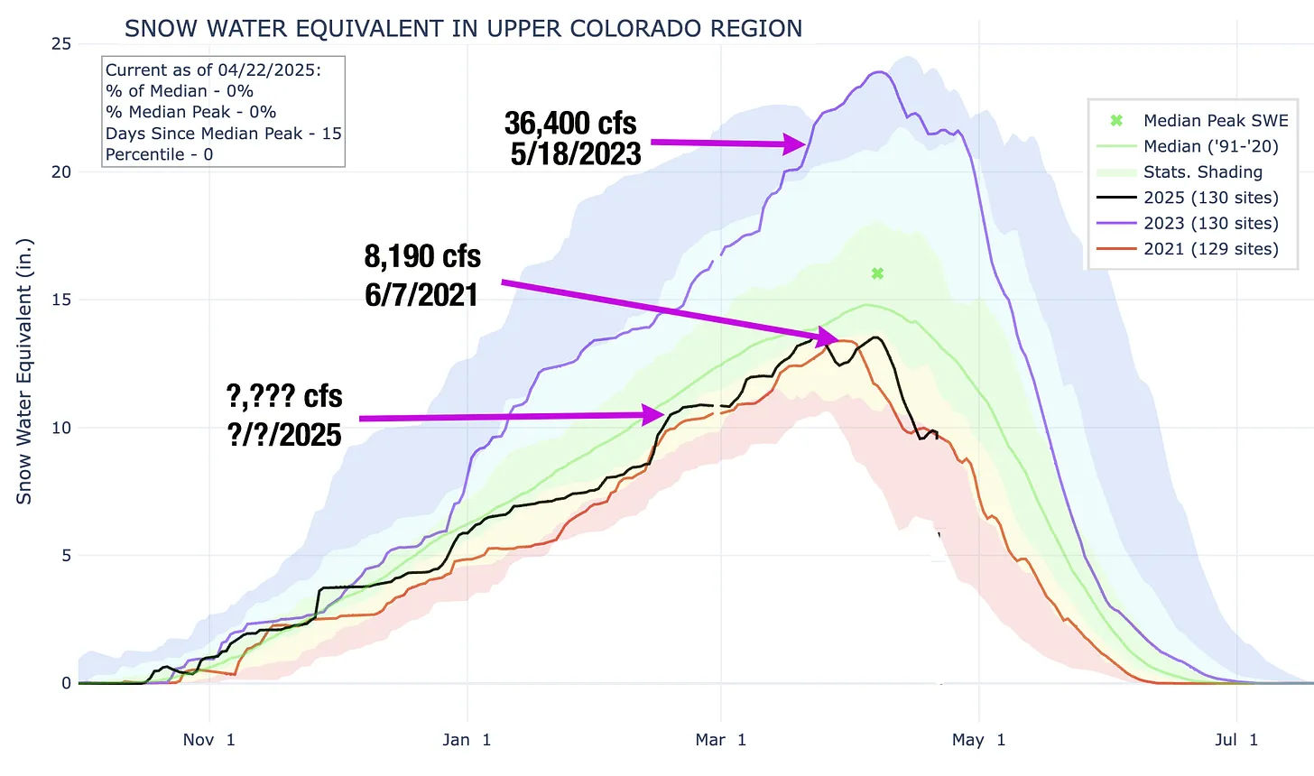
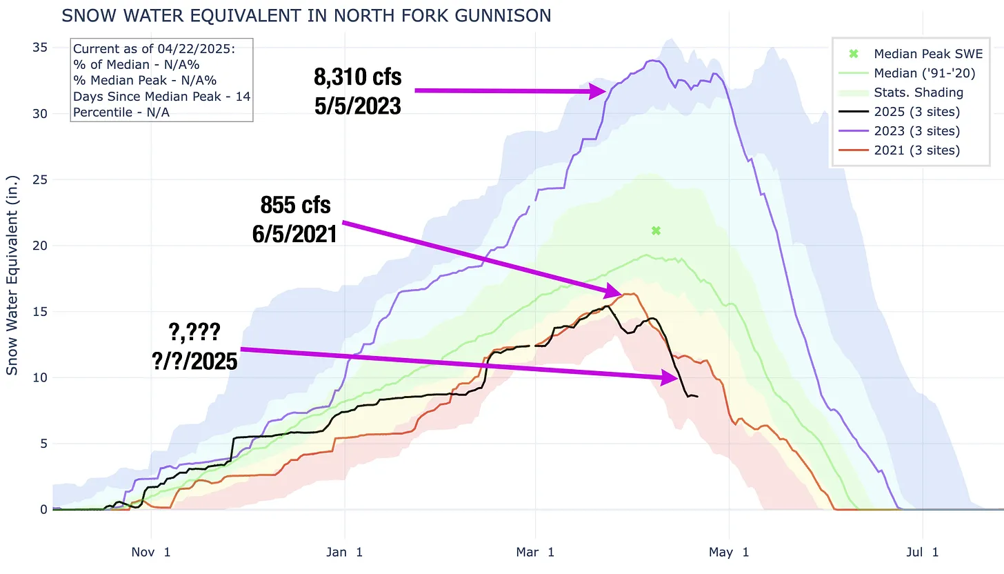
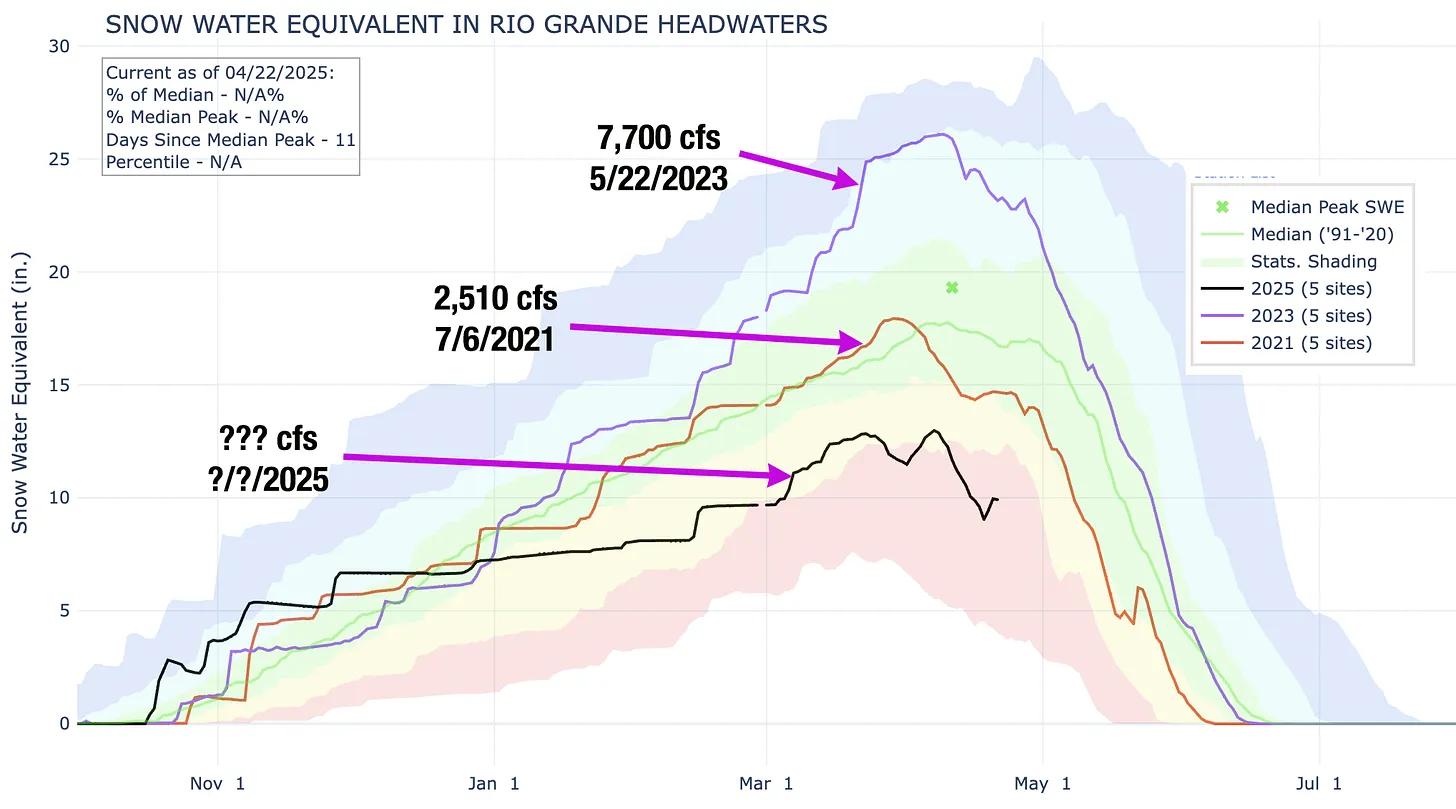
I’ve prepared the following graphs to help you out. They show this year’s April 22 snowpack level, along with the snowpack curve and peak flows and dates for 2021 and 2023. Good luck!


Streamflow readings are for the Colorado River gage at the Utah-Colorado state line. Source: NRCS, USGS.