#Drought news April 10, 2025: Deep seasonal #snowpack deficits remain across the ranges of southwestern #Colorado, #NewMexico, northern #Arizona, and southwestern #Utah

Click on a thumbnail graphic to view a gallery of drought data from the US Drought Monitor website.

Click the link to go to the US Drought Monitor website. Here’s an excerpt:

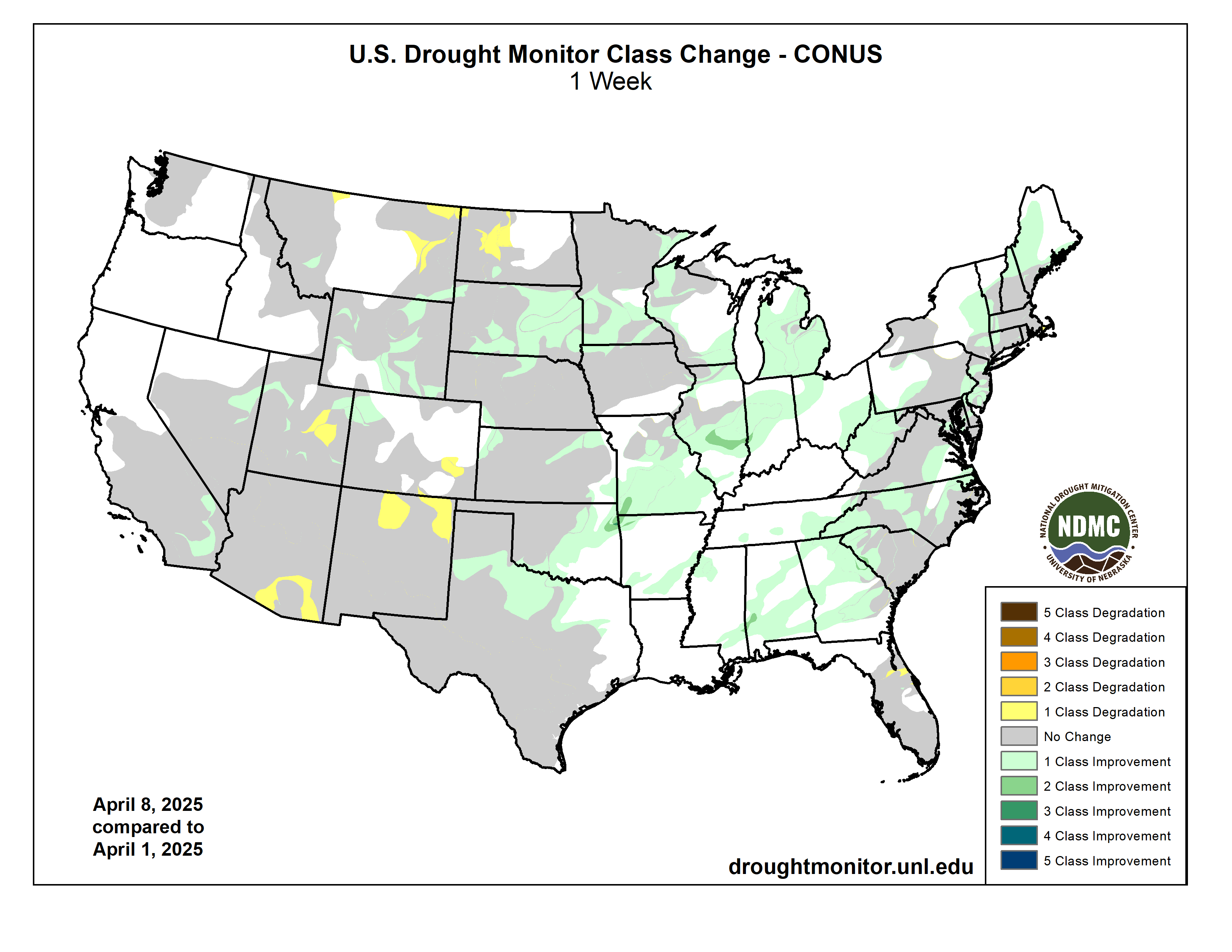
This Week’s Drought Summary

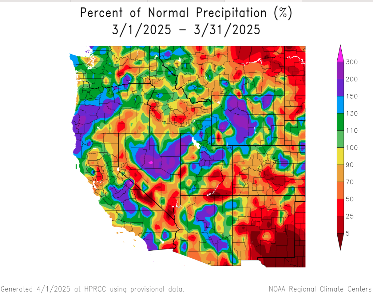
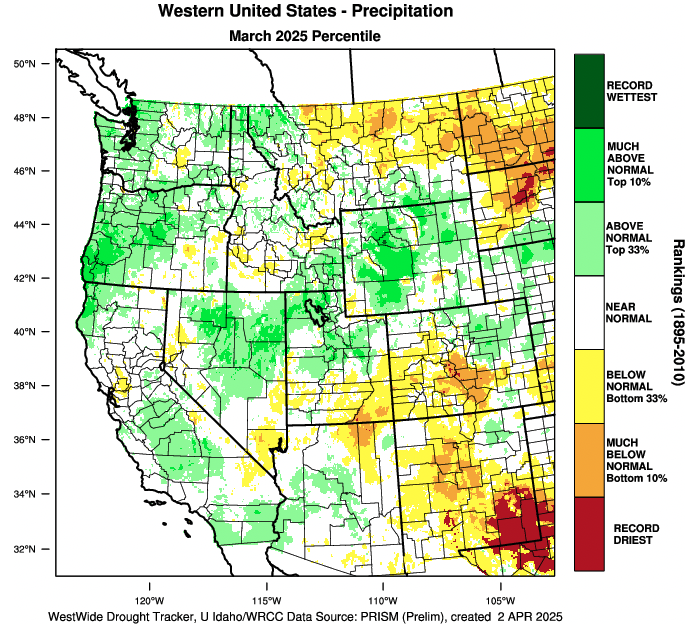
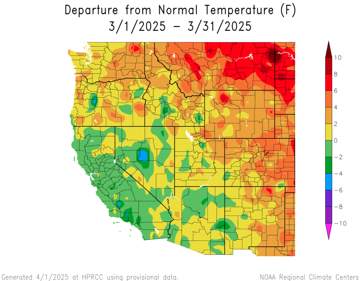
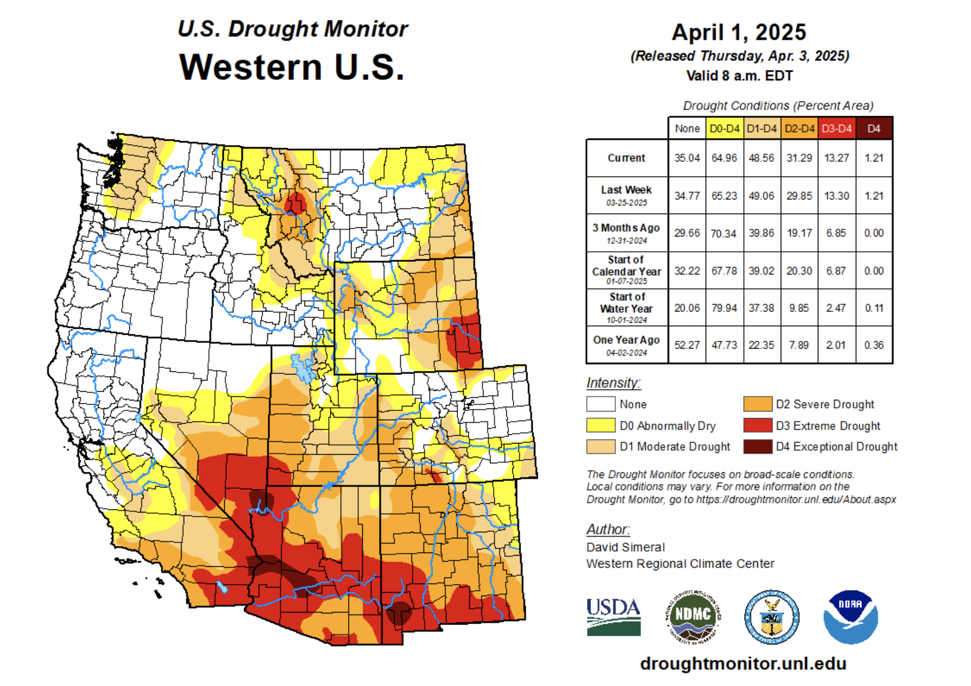
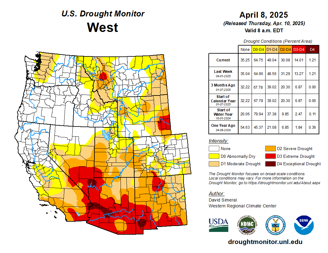
.This U.S. Drought Monitor (USDM) week saw widespread improvement in drought-related conditions across areas of the South, Southeast, and Midwest, where a series of strong storms delivered heavy rainfall, damaging winds, and severe flooding. The multi-day storm event saturated soils leading to inundation of rivers, and severe flooding in low-lying areas from Arkansas to Ohio. Storm totals from the multi-day event ranged from 4 to 18+ inches, with the highest accumulations observed across central Arkansas, southeastern Missouri, and western portions of both Tennessee and Kentucky. In addition to heavy rainfall, the storm system sparked dozens of tornadoes as well as strong gusty winds in other areas, causing widespread power outages. Elsewhere, improving conditions over the past 30 to 60 days, led to reduction in areas of drought in the Northeast, from New York to Maine, as well as in areas further south including New Jersey and Virginia. In the Midwest, this week’s rainfall event pushed rainfall totals well above normal levels for the past 30-day period, leading to improvements across the Midwest in Missouri, Illinois, Indiana, and Michigan. In the Upper Midwest and portions of the Plains, drought-related conditions improved on the map across areas of Minnesota, Wisconsin, and South Dakota, where precipitation has been above normal for the past 30-90-day period and soil moisture monitoring products are showing normal to above-normal levels. In the West, above-normal springtime temperatures are causing a rapid melting of high-elevation snowpacks across the entire region. Looking at the current snowpack conditions out West, deep seasonal snowpack deficits remain across the ranges of southwestern Colorado, New Mexico, northern Arizona, and southwestern Utah. Elsewhere in the region, areas of the Great Basin and Intermountain West saw improvements on the map including parts of northeastern Nevada, Wyoming, and northwestern Colorado. In terms of reservoir storage in the West, California’s reservoirs continue to be at or above historical averages for the date (April 8), with the state’s two largest reservoirs, Lake Shasta and Lake Oroville, at 116% and 120% of average, respectively. In the Southwest, the U.S. Bureau of Reclamation is reporting (April 6) Lake Powell at 33% full, Lake Mead at 34% full, and the total Colorado system at 41% full (compared to 42% full at the same time last year)…
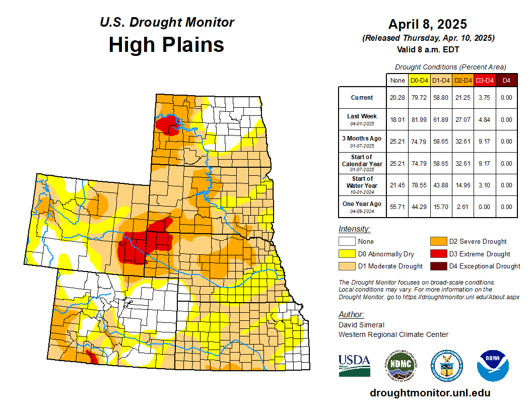
High Plains

On this week’s map, improvements were made in the region, namely in northern Kansas, northern Nebraska, and South Dakota, where shorter-term precipitation (past 30-60 days) is normal to above normal. Additionally, these areas were showing improvements in other drought indicators including soil moisture, streamflow activity, and satellite-based vegetation health. In western North Dakota, areas of Extreme (D3), Severe (D2), and Moderate (D1) drought expanded on the map in response to a combination of factors, including numerous recent impact reports from the agricultural sector, below-normal precipitation (past 30 days), and low streamflow and soil moisture levels. For the week, generally dry conditions prevailed across western portions of the region, while eastern portions received modest accumulations of <1.5 inches (liquid). In terms of temperatures, below-normal average temperatures (ranging from 2 to 10+ degrees F) were logged across the entire region…

Colorado Drought Monitor one week change map ending April 8, 2025.

West

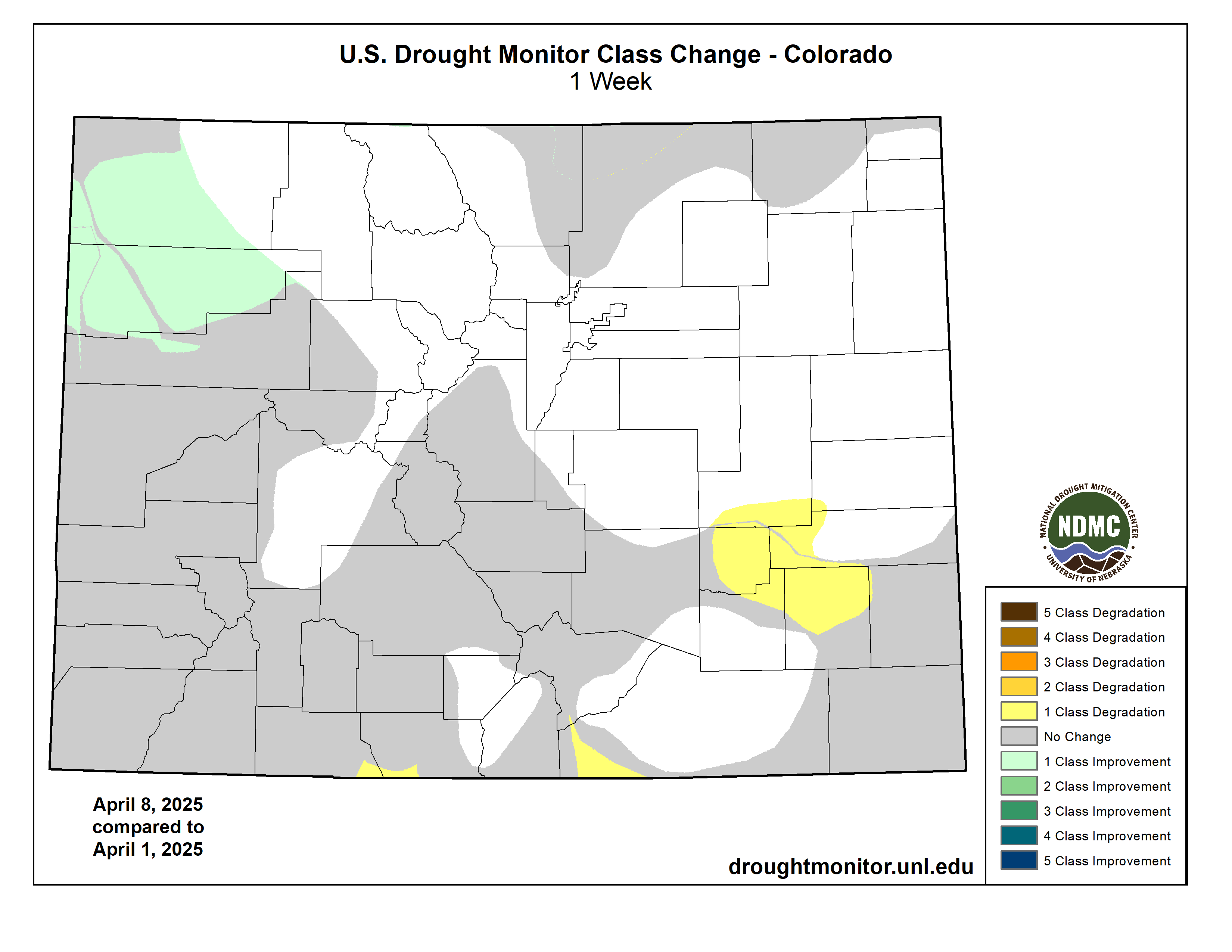
Out West, generally dry conditions prevailed over much of the region, including areas of California, the Great Basin, the Intermountain West, and the Desert Southwest (southern Arizona and southwestern New Mexico). However, some mountain locations in the Pacific Northwest and the Rocky Mountains received light-to-moderate precipitation accumulations. On the map, areas of Extreme (D3) drought were introduced in southeastern Arizona, where precipitation deficits existed at both short- and longer-term time scales. Similarly, ongoing below-normal snowpack conditions (snow water equivalent at NRCS SNOTEL stations ranging from 6 to 55% of median) in the Nacimiento, San Juan, and Sangre de Cristo ranges of New Mexico, led to the introduction of areas of Extreme (D3) drought. Elsewhere, some improvements were made on the map in drought-affected areas of northeastern Nevada, northeastern Utah, northwestern Colorado, and Wyoming. Looking at the regional snowpack, the NRCS SNOTEL network is reporting (April 8) the following region-level (2-digit HUC) SWE levels: Pacific Northwest 102%, Missouri 97%, Upper Colorado 89%, Great Basin 104%, Lower Colorado 69%, and Rio Grande 46%…

South

On this week’s map, widespread improvements were made in response to very heavy rainfall accumulations observed across parts of the region, with the highest totals (ranging from 5 to 15+ inches) observed in northeastern Texas, eastern Oklahoma, Arkansas, western Tennessee, and southern Mississippi. The multi-day storm event led to catastrophic flooding in parts of the region as well as tornadic activity, widespread power outages, and loss of life. However, the deluge of rains also led to significant improvements in drought-related conditions, with multiple category improvements made on the map. For the week, average temperatures were above normal in eastern areas, with anomalies ranging from 3 to 12 degrees F. Conversely, the western extent of the region, including much of Texas, Oklahoma, and Arkansas, experienced temperatures ranging from 3 to 12 degrees F below normal. Looking at Texas reservoir conditions, statewide reservoirs are reported to be 75.7% full, with many reservoirs in the eastern part of the state in good condition (over 90% full), while numerous reservoirs in the western portion of the state continue to experience below-normal levels, according to Water Data for Texas (April 9). In terms of streamflow activity (April 9), the U.S. Geological Survey is reporting well above normals streamflows (>90th percentile) across northeastern Texas, southeastern Oklahoma, Arkansas, Mississippi, and western Tennessee, while areas of central and southern Texas are experiencing below normal levels (1st to 24th percentile range)…

Looking Ahead

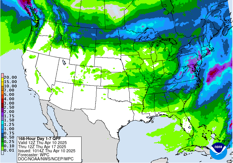
The NWS Weather Prediction Center (WPC) 7-Day Quantitative Precipitation Forecast (QPF) calls for relatively dry conditions across the conterminous U.S., except for light-to-moderate accumulations across areas of the Pacific Northwest, northern Plains, Lower Midwest, Mid-Atlantic, and the Northeast. The Climate Prediction Center (CPC) 6-10-day Outlook calls for a moderate-to-high probability of above-normal temperatures across the Western U.S., Plains, and areas of the South, while below-normal temperatures are expected across eastern portions of the Midwest and portions of the Northeast. Elsewhere, near-normal temperatures are favored. In terms of precipitation, there is a low-to-moderate probability of above-normal precipitation across New Mexico, Texas, and Oklahoma as well as areas of the Upper Midwest. Elsewhere, below-normal precipitation is expected across most of the West, Southeast, and Mid-Atlantic.

US Drought Monitor one week change map ending April 8, 2025.

The latest briefing (April 8, 2025 #Colorado #Utah #Wyoming) is hot off the presses from Western Resource Advocates

Click the link to read the briefing on the Western Resource Advocates website:

With the snow accumulation portion of the 2025 water year drawing to a close, snowpack in much of the region was near average, except for southern Colorado, southern Utah and northeastern Wyoming where snowpack ranged from 50-80% of average. Above average precipitation in northern Utah and much of Wyoming added to snowpack during March and caused the removal of drought conditions from the Wasatch Front and northern and central Wyoming. A late-March rain/snow event produced record precipitation along the northern Front Range and Eastern Plains and alleviated drought. Seasonal streamflow volume forecasts vary from much below average in southern Utah and southwestern Colorado to near average forecasts for more northerly river basins such as the Colorado headwaters, Yampa, North Platte and Bighorn River Basins. The streamflow volume for Lake Powell’s inflow is forecasted at 67% of average.

March precipitation was near-to-above average in Wyoming and much of Utah. Below average March precipitation fell across much of Colorado and southeastern Utah. In northern Utah, March precipitation was 130-200% of average and large areas of Wyoming received 130-300% of average March precipitation. Parts of southern Colorado and southeastern Utah received less than 50% of average March precipitation, further worsening drought conditions. Six long-term weather monitoring sites in eastern Colorado received record-low March precipitation.

March temperatures were mostly above average. In Utah and southwestern Colorado, March temperatures were within two degrees of average. March temperatures in other parts of Colorado and Wyoming were two to six degrees above average.

April 1 snow water equivalent (SWE) was near average for much of Wyoming, northern Colorado and northern Utah, ranging from 90% in the Lower Green to 110% in the Upper Snake River Basins. In southern Colorado and southern Utah, April 1 SWE was below to much below average, ranging from 44% in the Virgin to 80% in the Gunnison River Basins. On a statewide basis, SWE was near average in Utah (92%) and Wyoming (100%), but below average in Colorado (84%). In southwestern Utah, eight Snotel sites at elevations ranging from 6,000-8,900 feet have completely melted, which is 14 to 34 days earlier than average.

Spatial estimates of SWE on March 31, provided by INSTAAR at the University of Colorado, show lower estimates of SWE relative to average for all river basins except Wyoming’s Bighorn, Snake and Yellowstone Basins. The lower percent average SWE from spatial SWE estimates compared to Snotel-derived SWE is largely due to the inclusion of low elevation snowpack in the spatial SWE estimates which is not well-represented in the Snotel network. Snowpack at elevations below Snotel sites was generally low in 2025 due to higher snow levels and periods of warm sunny weather in March. The entire Spatial SWE report for 3/31/25 can be downloadedĀ here.

April 1 seasonal (April-July) streamflow volume forecasts were near-to-below average across the region. In general, seasonal streamflow volume forecasts were near average in the North and below or much below average in the South. In the Upper Colorado River Basin, near average streamflow volumes are forecasted for the Colorado Headwaters (90%) and the Yampa (94%); below average streamflow volumes for the Upper Green (80%), Lower Green (80%) and Gunnison (85%); and much below average streamflow volume for the Dolores (55%) and San Juan (48%). Seasonal streamflow is forecasted at 67% of average for Lake Powell. In the Missouri River Basin, near average seasonal streamflow volumes are forecasted for the Bighorn and North Platte River Basins, and below average streamflow is forecasted for the Arkansas, Cheyenne, Powder, South Platte and Tongue River Basins. Note: both NRCS and the Colorado Basin River Forecast Center (CBRFC) provide seasonal streamflow forecasts for the Upper Colorado River Basin and these forecasts occasionally differ due to differences in streamflow forecasting models. For example, the April 1, 2025 seasonal streamflow forecast for the Upper Green River at Flaming Gorge is 80% from the CBRFC and 94% from the NRCS.

On April 1, drought conditions covered 54% of the region, a 2% regional decline from February 25. Significant expansion of drought in Colorado during March was offset by the removal of drought conditions along the Wasatch Front in northern Utah and in northern and central Wyoming. Extreme drought conditions were removed from the Snake and Powder River Basins and the area of severe drought contracted during March. Drought conditions expanded and became more severe in western Colorado and drought conditions emerged in both central and southeastern Colorado during March.

Pacific Ocean temperatures were near average in March, ENSO is currently in a neutral phase, and there is a greater than 50% probability of ENSO-neutral conditions continuing through early fall. The NOAA monthly outlook for April suggests an increased probability of below average precipitation and above average temperatures across most of Colorado and Utah. The NOAA Seasonal Precipitation Outlook (April-June) indicates an increased probability of below average precipitation for the entire region, especially in Utah and western Colorado. There is also an increased probability of above average temperatures for Colorado, Utah and southwestern Wyoming during April-June.

Significant weather event: Record Front Range precipitation.Ā After a dry January-March, record precipitation fell across the northern Front Range and Eastern Plains of Colorado on March 29-30. Rain fell for most of the event at lower elevations with wet snow accumulating in the foothills. Daily precipitation records were set on March 29 in Boulder (1.41ā€), Brighton (0.46ā€), Eastonville (0.70ā€), Greeley (0.60ā€), Longmont (0.66ā€) and Winter Park (0.76ā€) and two-day precipitation records were set on March 29-30 at 11 locations with more than 50 years of data. Notably, more rain fell on March 29-30 than in all of 2025 at 18 locations. The late March rain and snow event caused a one-category improvement in drought conditions, including the removal of all drought and abnormally dry conditions across a large swath of northeastern Colorado. An area of extreme drought was also removed from Larimer County.

#Colorado #Snowpack Approaches Seasonal Peak — NRCS

Click the link to read the release on the NRCS website:

April 8, 2025

As Colorado approaches the seasonal peak of its snowpack, data as of April 1 show statewide snow water equivalent at 85 percent of median, down from 112 percent this time last year. March delivered 105 percent of median precipitation across the state, improving snowpack totals in many basins.

As of April 1st Colorado’s snow water equivalent (SWE) is at 85 percent of median, compared to 112 percent on this date last year. Statewide monthly precipitation for March reached 105 percent, while water year to date (WYTD) is at 92 percent of median. March brought increased storm activity, bolstering precipitation and snowpack values, especially across western, northern and central basins. The southern half of the state remains below average, reflecting the extended period of below average precipitation from December through February. However, 30-day precipitation totals through March show improvements. The Gunnison, Arkansas, Upper Rio Grande (URG) and combined San Miguel-Dolores-Animas-San Juan (SMDASJ) basins each record above to near average precipitation for the month, with values reaching 108, 77, 86 and 117 percent, respectively. Even with the recent increase in March precipitation, snowpack remains below median in the Gunnison, Arkansas, Upper Rio Grande and combined SMDASJ basins which are at 81, 74, 56 and 63 percent of median, respectively. 

Throughout the final week of March, all basins in the state experienced snowmelt, most notably in the southern half of the state where accelerated melt occurred at many sites. In the Upper Rio Grande basin snowmelt is particularly pronounced with several sites showing both lower than average peak SWE and faster than normal melt rates. Statewide median peak SWE typically occurs April 8th, although actual timing varies basin to basin. The Headwaters of the Rio Grande sub-basin are days away from peak with the median date around April 11th. Following a storm over the first weekend of April the Headwaters of the Rio Grande sub-basin records a modest boost in SWE, now holding 73 percent of median and ranking in the 17th percentile.

Colorado’s northern river basins all have near to above median snowpack ranging from 93 to 103 percent. As of April 1st, the South Platte is at 98 percent of median snowpack, the Laramie and North Platte at 103 percent, Colorado Headwaters is at 96 percent and the Yampa-White-Little Snake at 93 percent. Each of these basins have reached approximately 84 to 91 percent of median peak SWE, with room to grow before their median peak dates in mid to late April. 

While April has the potential to deliver meaningful snowpack accumulation, it’s worth noting that many sites in southern basins have likely already passed their seasonal peak. Median peak SWE dates in these basins range from April 2nd to April 8th. To date, the Arkansas, URG and SMDASJ reached their highest SWE around March 23-24. Current SWE as a percent of median ranges from 47 to 71 percent in southern basins. These values reflect a notably below average snowpack and while not all sites are record breaking, there are some sites among the lowest on record or near record at several locations. Of the 198 SNOTEL and snow course sites in Colorado, 40 sites (20% percent) currently fall withing the lowest 15th percentile for their respective period of records. ā€œThese values reflect how far off some sites are from their typical accumulation and highlight the larger picture of below normal snowpack in the southern basins,ā€ says Nagam Gill, NRCS hydrologist. SNOTEL records in this group span 9 to 47 years, while manual snow course surveys extend from 42 to 88 years of data. 

Statewide reservoir storage is at 92 percent of median and 58 percent of total capacity. While this is slightly below last year’s 100 percent of median at this time, most major reservoir across the state observe near 30 year medians. Dillon Reservoir is at 97 percent of median and 80 percent capacity and Lake Granby holds 101 percent of median at 58 percent capacity. Pueblo Reservoir is at 109 percent of median and 71 percent of capacity. The streamflow forecast at Pueblo Reservoir Inflow project 370,000 acre-feet for the April – September period or 94 percent of median and has stayed consistent from last months projections. Blue Mesa is at 96 percent of median and 60 percent of capacity. Notably below average is McPhee Reservoir at 76 percent of median and 56 percent of capacity. 

April 1Ā volumetric streamflow forecasts reflect snowpack and precipitation conditions across Colorado at 86 percent of median. Forecasts are near to above average for northern basins and below to much below average for the southern half of the state. Statewide, 40 percent of forecast points are at 75 or less of median and 27 percent of those points fall in the lower 25thĀ percentile. Navajo Reservoir Inflow forecasts a 325 kaf median departure from the period of record (POR) median. McPhee Reservoir Inflow is at 64 percent of median with a 91 kaf departure. Forecast volumes in the Colorado Headwaters, Yampa-White-Little Snake, Laramie and North Platte, and South Platte are at 96, 95, 102 and 93 percent of median seasonal streamflow volumes, respectively. In contrast, the Gunnison, Arkansas, URG and combined SMDASJ basins are forecast at 86, 87, 63 and 60 percent of median, respectively. These outlooks reflect the considerable differences in peak SWE and melt out trends already underway in the southern portion of the state. Compared toĀ March 1Ā outlooks, forecast volumes decline by roughly 12 to 15 percentage points in the URG and SMDASJ basins, driven by accelerated snowmelt during late March. The variability of forecasted volumes means that relying solely on the 50% exceedance forecast may not fully capture the uncertainty in future weather. A critical consideration when reviewing these forecasts is theĀ full suiteĀ of exceedance probabilities.

The April 1, 2025 #Colorado Water Supply Outlook is hot off the presses from the NRCS

Click the link to read the outlook on the NRCS website. Here’s an excerpt: