Mrs. Gulch’s landscape April 6, 2025


Click the link to read the article on the Water Education Coloado website (Jerd Smith):
April 2, 2025
If a river running through your town is overused and underloved, it might be in line for a first-of-its-kind statewide restoration program, designed to assess and improve a river’s health, its recreational assets, and its safety.
In March, Great Outdoors Colorado and the Colorado Water Conservation Board approved a combined $417,000 in seed money to launch the program, according to Emily Olsen, regional vice president of Trout Unlimited. The fish advocacy group is helping lead the initiative, known as Colorado Rivermap, along with the U.S. Bureau of Land Management.
The project will launch this year with the selection of a technical team to identify the river segments that are most in need of help, according to Doug Vilsack, Colorado state director for the BLM.
“This is getting the big thinkers together and using the seed funding to see which reaches of rivers need our attention and how much funding we will need,” Vilsack said.
They’ll be looking for parks and river access points that are rundown and in need of repair and restoration. They’re on the hunt for stretches of river that have no access points, and those that have been used so heavily that streambanks are eroding.
Once the inventory is complete, the mapping group will turn to advocacy groups and agencies like Great Outdoors Colorado to ask for funding to make the improvements.
Colorado Rivermap has received letters of support from several local governments and counties, including Chaffee and Grand counties. And Olsen said local communities that want to be involved will be key to making sure there is main-street involvement in the work.
“We are going to think hard about where we can add value and find things local communities can support,” she said.
Other backers that will provide funding for the initiative include the Foundation for America’s Public Lands, Colorado Parks and Wildlife, and American Whitewater, Olsen said.
Colorado is known for its scenic waterways and is home to eight major river basins, from the South Platte on the Front Range, to the Yampa River Basin in the northwestern corner of the state, to the headwaters of the Colorado River, in Grand County.
The rivers help lure millions of tourists to the state, intent on rafting and fishing in their waters and camping along their shores.
In 2023 the state saw record-high visits, with tourist numbers hitting 93.3 million and visitors spending $28.3 billion, according to reports by visitor research firm Longwoods International.
But the state’s soaring popularity has also begun to wear on its iconic streams. The waterways, Vilsack said, “will be in tougher shape if we don’t do this.”
The initial survey of the rivers comes as Colorado launches a statewide recreation strategy, said Chris Yuan-Farrell, programs director for Great Outdoors Colorado.
“We are planning what we need for outdoor recreation, habitat and natural resources health. Rivers are obviously a big component of this,” Yuan-Ferrell said.
Initial steps include formation of the technical and mapping team. Olsen said they also plan to dramatically expand the team to include state and federal governments and private businesses with a stake in Colorado’s recreation economy. Vilsack said they expect this work to be completed within two years.
Anyone interested in the project can contact Olsen at emily.olsen@tu.org.

Click the link to read the article on The Land Desk website (Jonathan P. Thompson):
April 4, 2025
Last August, I wrote an incredulous and somewhat tongue-in-cheek story about then-candidate Donald Trump’s plan, as outlined a year and a half earlier on his Agenda 47 website, to build 10 “Freedom Cities” on “empty” public lands in the West.
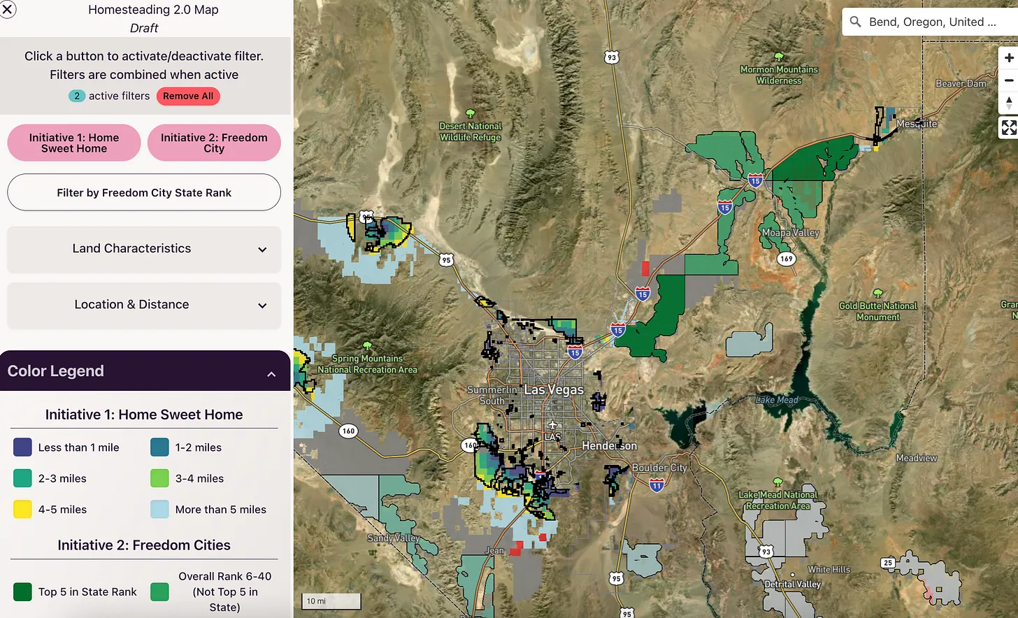
I didn’t take it seriously. Maybe I should have. Trump hasn’t said much about Freedom Cities since being elected, but other people have taken the idea, spiffed it up a bit, and run with it. One enigmatic group, for example, wants to convert the Presidio Trust in San Francisco into a Freedom City. And the American Enterprise Institute has incorporated Freedom Cities into its audacious Homestead 2.0 plan to “make housing affordable again.”
Indeed, the cities and similar efforts to hand over federal land to housing developers may be the very tool Western right-wing activists have been looking for to finally transfer public land out of the American public’s hands.
Efforts to privatize the public domain have flared up for over a century. In the early part of the 20th century, Sen. Albert Bacon Fall, of New Mexico, urged his colleagues to turn over forest reserves to states and private interests. In the 1940s, Western lawmakers and the livestock lobby attempted to transfer all Bureau of Land Management lands to private ownership. And in the late 1970s, the Sagebrush Rebellion’s legal arm, the League for the Advancement of States Equal Rights, endeavored to convey federal lands to the respective states, at which point they could be sold off to the highest bidder.
These movements were echoed in the 1990s, the 2000s, and in the 2010s. But each conflagration was ultimately doused. Proponents realized that mining, grazing, and drilling federal lands was much cheaper than doing so on state or private lands, and that they had no support outside of a handful of Western counties.
Over the last few years, the embers have been rekindled in the form of lawsuits, state-level legislation, and far-out campaign proposals. While I certainly have taken note of and written about these bids, I also haven’t taken them all that seriously: They, too, would collapse as it became clear that their flimsy legal grounding couldn’t stand up to public opposition.
More recently, however, I’ve begun to have my doubts.
No, I don’t think Utah will ever win its land grab lawsuit, nor will the Wyoming Freedom Caucus’s bid to seize control of all federal land within its borders — even national parks — succeed, even in the state legislature. But the growing number of proposals from both Democrats and Republicans to use federal land for housing and for siting data centers and associated power generating facilities — while also using proceeds of land sales to offset tax cuts for the wealthy — seem set to come together and make the Sagebrush Rebellion fantasy a reality.
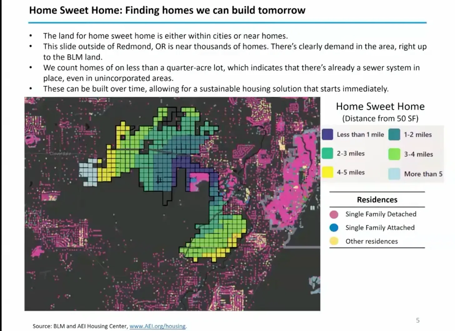
The thing that got me thinking about all of this was a video of a recent AEI conference, in which the right-leaning*, free-market think tank introduced its Homesteading 2.0 plan. In a nutshell, the plan — which is broken up into the Home Sweet Home and Freedom Cities phases — looks like this:
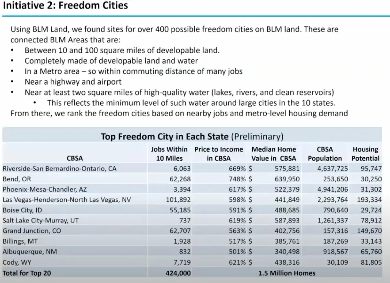
- The Bureau of Land Management would sell off 850 square miles, or about 544,000 acres, of developable public land in or near existing metro areas. About 250 of those square miles would fall under the Home Sweet Home phase, with the remaining 600 square miles devoted to 20 Freedom Cities around the West. They say this would generate $100 billion for the U.S. Treasury, which would mean the land would sell for an average of about $183,000 per acre.
- Under the Home Sweet Home phase, a total of 1.5 million new homes would be built on that newly privatized land within existing metro areas on the current urban fringe.
- Another 1.5 million homes would be built in Freedom Cities, which would lie outside — but not far from — existing metro areas’ peripheries.
After getting this far, I was ready to shut off the video and go back to watching reels of mountain biking wipeouts. There’s no way that such a grandiose plan could garner the necessary support to actually occur, even if it had been stripped of Trump’s nuttiest embellishments. No matter how these folks spin it, 544,000 acres is a lot of public land to transfer, especially given the fact that high profile Republicans such as Sen. Steve Daines and Rep. Ryan Zinke have come out strongly against large-scale public land transfers.
But under our current bizarro political regime, anything is possible, especially the zany and grandiose. I wouldn’t be surprised if the AEI folks threw in the Freedom Cities just to spice up their Home Sweet Home plan and to grab Trump’s attention. Because if you get Trump’s support, you automatically gain the backing of 95% of the Republicans in Congress. Get Elon Musk on board and it’s a slam dunk, especially if it raises $100 billion to offset tax cuts to the wealthy. (Zinke and Daines will back down from their stances instantly if bullied by Trump to do so).
AEI senior fellow Ed Pinto said the initiative would gain access to the land via the existing authority of the Interior Secretary to dispose of public lands, plus the congressional reconciliation bill, and “emergency” presidential powers. “We’re talking basically undesignated BLM areas,” Pinto said, “some of it may be designated as conservation areas, some of it may be ranch land …” (So much for the “undesignated” part).
One thing that struck me was the similarity between these right wing policy folks’ arguments and those made by YIMBY progressive housing advocates. Both blame the housing affordability crisis on a lack of supply, both say the solution is to build more housing, and both agree that the best way to do that is to reduce bureaucratic red tape and to up-zone land. That’s when state and local governments encourage density and multiple use by getting rid of or reducing minimum lot sizes and abolishing sprawl-friendly single-family-only zoning laws. “Zoning gets in the way of the highest and best use of land,” said Pinto.
This could help get Democrats and progressives on board with the plan, even if it means transferring public lands. After all, while almost anyone on the left eagerly pushes back against Big Oil or Big Beef land grabs, they may be far less enthusiastic about fighting Big Housing.
While progressive housing advocates are more likely to combine up-zoning with government subsidies and support, AEI is adamant about letting the market do its thing. “We’re gonna add supply, not with subsidies,” said AEI senior fellow Ed Pinto in the video. “This land is going to be sold at market rate … We’re making it more affordable the old fashioned way: build smaller houses on smaller lots and the price goes down.” Pinto added that he is not necessarily on board with Interior Secretary Doug Burgum’s similar plan to use public lands for affordable housing, because Burgum’s very vague plan is not laissez faire enough.
AEI is shooting for 13 houses per-acre, which is about twice as dense as Las Vegas currently. Yet it’s not clear how the plan would ensure that developers built the small homes AEI is looking for. Also a big question mark is who the hell is going to pay for the infrastructure for these developments, especially in Freedom Cities, which are mostly way out beyond the existing utilities and roads.
Pinto indicated that the Freedom Cities wouldn’t be as much of a reach as they might sound. He pointed to giant master-planned communities as models, including Columbia, Maryland; Reston, Virginia; Villages, Florida; and Sun City/Georgetown, Texas. But his main example was Teravalis, a planned new city on nearly 60 square miles of land in Buckeye, about an hour’s drive outside of Phoenix, where Howard Hughes Holdings hopes to build 100,000 homes and over 50 million square feet of commercial development.
That brings up an important point that the AEI folks barely touched upon before brushing it off: water, and the increasing lack thereof. Teravalis has received its land-use approvals for the whole project. But the state has issued the required 100-year assured water supply certification for just 8,500 of the development’s homes. In 2023, Arizona halted new certifications for groundwater-reliant areas on Phoenix’s fringe, throwing the future of Teravalis’s remaining 91,500 planned homes into doubt. A new Freedom City in the same region would run up against similar limits. And the 1.27 million new homes these guys are planning for Southern Nevada? Umm … hello! They don’t have any more water, folks.
But that seems to be of no concern to the AEI folks or, for that matter, various Nevada leaders who are pushing similar, if less ambitious, plans.
U.S. Rep. Susie Lee, a Nevada Democrat, recently introduced legislation that would make 25,000 acres of BLM land in Clark County, i.e. the Las Vegas area, available for housing over the next 50 years, while also setting aside other public land as wilderness, following the model of similar legislation Congress passed in 1998. It mirrors Democratic Sen. Catherine Cortez Masto’s bill introduced last year. Nevada Republican Rep. Mark Amodei forwarded a similar bill for the northern part of the state. And last year Sen. Mike Lee, a Utah Republican introduced his Helping Open Underutilized Space to Ensure Shelter — or HOUSES Act — that would allow state and local governments to nominate tracts of “underutilized” (meaning not actively being drilled or grazed to death) public land for purchase.
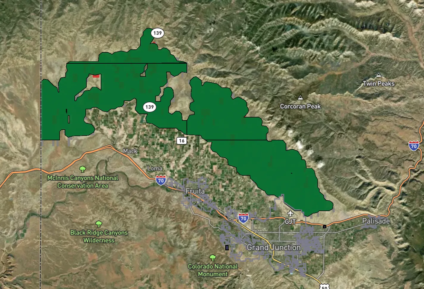
These bills and Burgum’s plan lack details. The AEI plan, on the other hand, is more than just an abstract concept. The think tank has actually mapped out specific BLM parcels that would be targeted for development. It’s worth checking out the map to see for yourself, but some of the sites that stand out include:
- Three potential Freedom City sites north of Grand Junction, stretching from Clifton to the Utah border;
- Another one that would cover Mormon Mesa near Mesquite, Nevada, not far from the iconic land art, Double Negative;
- And yet another at Fredonia, Arizona.
This whole Homesteading 2.0 thing, and especially the Freedom Cities part, is a long-shot, maybe even a pipe dream. But these days, anything’s possible.


Click the link to read the article on the Pagosa Springs Sun website (Kristy Burnett):
On April 1, Gov. Jared Polis and the Colorado State Forest Service (CSFS) announced $7.04 million in wildfire mitigation grants.
In total, the CSFS will award the $7.04 million to 37 projects in 26 counties across Colorado.
Included in the funding is Wildfire Adapted Partnership for community fuels reduction in Southwest Colorado
Colorado’s diverse forests cover more than 24 million acres, and they provide crucial benefits, including clean air and water, habitat for wildlife, outdoor recreation and more.
All of these values that Colorado’s forests provide are at risk of wildfire. Since 2018, the state of Colorado has provided funding to assist communities and groups across Colorado to reduce their wildfire risk and promote forest health through the Forest Restoration and Wildfire Risk Mitigation (FRWRM) grant program, administered by the CSFS.
“Preventing wildfires is an all-hands-on-deck effort in Colorado. Wildfires continue to be a serious threat to Colorado communities, and investing in fire mitigation initiatives and helping communities create defensible spaces helps all Coloradans and firefighters to be better prepared in the event of a fire emergency. This $7.04 million in wildfire grants will provide the essential resources that are crucial to continue building resilience to wildfires across Colorado,” Polis said.
The FRWRM grant program has a matching requirement, either through cash or in-kind contributions.
Award recipients in areas with fewer economic resources, as defined by the social vulnerability index layer within the Colorado Forest Atlas, must match 25 percent of the project total, and all other award recipients must match 50 percent of the total project cost, amounting to nearly $9 million in match.
With these matching funds included, communities and groups across Colorado will invest about $16 million in efforts dedicated to forest restoration and wildfire mitigation. The projects awarded in this funding cycle will also build capacity for wildfire mitigation projects through staffing and equipment purchases.
The funding for this round of FRWRM awards will help Coloradans complete the following activities:
- Build community capacity to address wildfire.
- Reduce the risk of wildfire to people, property and infrastructure.
- Promote forest health and restoration.
- Encourage the use of wood from forest health and fuels reduction projects.
“Addressing forest health and wildfire mitigation at the local level is the most efficient and effective way to make Colorado’s forests more resilient,” said Matt McCombs, state forester and director of the CSFS. “This funding is crucial each year to protect our homes, critical infrastructure and our way of life.”
For the 2024-2025 round of FRWRM grants, the CSFS received 95 eligible applications requesting nearly $25 million. Since $7.04 million was available for this round of grants, 58 projects totaling nearly $15.4 million could not be funded. In addition, of the 37 awarded projects, the CSFS could only partially fund six of them, leaving about $2.5 million of their original requests unfunded.
“The Colorado State Forest Services FRWRM grant is a critical element in our overall state efforts to improve forest health and reduce the risk of wildfires on our landscapes, and creating fire-adapted communities,” said Dan Gibbs, executive director of the Colorado Department of Natural Resources. “Colorado is one lightning strike and one unattended campfire away from our next wildfire. With about half of all Coloradans living in the wildland-urban interface, these grants provide important capacity for locally and regionally driven wildfire prevention efforts.”
The CSFS will announce the next round of funding assistance through the FRWRM grant program in the fall. For information about the program, visit the CSFS website.

Click the link to read the article on the Alamosa Citizen website:
April 4, 2025
The next time a water exportation project is pitched to move water from the San Luis Valley – and there will be a next time – the speculator will learn the value of that water to the six-county region measures into the billions of dollars.
A new report by American Rivers and senior economist Claire Sheridan of One Water Econ captures for the first time the economic value of the water that runs through the San Luis Valley. It was a study prompted in 2022 by the threat of water exportation from the Upper Rio Grande Basin by Renewable Water Resources.
As part of its proposal to export and sell 20,000 acre-feet of water every year from the Valley, RWR offered to establish a $50 million community fund that it argued would fairly compensate the Valley for its water. The study, “The Economic Value of Water Resources in Colorado’s San Luis Valley,” pegs fair compensation of the RWR proposal at around $1.3 billion per year. (More on that figure below)
“It’s a really complex question to answer. What is the value of water in the San Luis Valley?” said Heather Dutton, manager of the San Luis Valley Water Conservancy District. “The value of water in the San Luis Valley is so much greater than a one-time payment of $50 million.”
Dutton, Sheridan from One Water Econ, and American Rivers’ Emily Wolf presented the findings of the report at the annual Rio Grande State of the Basin Symposium held March 29 at Adams State.
The study goes beyond putting a dollar value to water for the Valley’s agricultural purposes. It also examines the value of water as it relates to the Valley’s outdoor recreation industry and wildlife and natural habitat surroundings.


And it looks at “water-dependent” industries that are key to the Valley’s economy and their reliance on water for their customers and sanitation services. Those “water-dependent” industries like San Luis Valley Regional Medical Center and Adams State University account for approximately 21 percent of total direct economic output and 23 percent of employment in the Valley, according to the study.
“Capturing the value of water as it is used in homes, businesses, and for environmental purposes can add important information to conversations about the future of the Valley and its water resources,” noted the study’s authors.
The study puts into perspective how valuable water in the Upper Rio Grande Basin is when you apply it to the Valley’s economy and livelihood. According to the report, the San Luis Valley economy generates $4.5 billion in total annual economic output, largely driven by hospitals, electric power companies, insurance, crop farming and cattle ranching. Alamosa and Rio Grande Counties account for 60 percent of the population and 67 percent of total economic output in the region.

Other insights from the report:
- Agriculture in the San Luis Valley, including cattle ranching, generates 10 percent of all output in the region (although this varies significantly by county) and makes up 39 percent of Colorado’s total agricultural output.
- Agriculture is the single largest private employer in the SLV, and irrigated agriculture employs 8 percent of the total workforce (an estimated 2,322 jobs per year). Approximately 64 percent of these jobs are in the category of all other crop farming (which represents alfalfa and grass hay) and 34 percent are in vegetable farming (mostly potatoes).
- The agriculture, forestry, fishing, and hunting sector generate over 4,000 jobs each year. This sector also leads in economic output, generating $566 million annually.
- The value of clean drinking water in the San Luis Valley is estimated to be over $3,600,000 per day.
The analysis also found that water-related habitat in the Valley is valued at more than $49 million annually and the annual Crane Festival generates $4 million in direct revenue from visitor spending.
“It’s just apparent that just as water flows through this community, so do the dollars that are generated from that water,” said economist Claire Sheridan.
Sheridan did the math for the audience at the Rio Grande Symposium in explaining how far under value RWR’s $50 million community fund pitch was when considering the value of water to residents of the Valley.
She used a model FEMA goes by in its emergency management work that factors in two components in creating a value for water to a community: One component is a willingness to pay for clean and safe drinking water. “If you go to your tap and turn on your water, what are you willing to pay to make sure that you can drink that water? What is that worth to you?” The other component is “avoided replacement cost” that factors in costs if a resident has to go buy water.
For the San Luis Valley and its estimated population of 46,600, those two components combined come out to about $77.23 per person, per day, said Sheridan. When you apply $77.23 to the Valley’s population, the value for clean drinking water in the San Luis Valley is about $3.6 million per day or $1.3 billion annually.
Click the link to read the article on the Inside Climate News website (Georgina Gustin):
April 4, 2025
The Department of Agriculture issued an “Emergency Situation Determination” that environmental groups say will speed the cutting of old-growth trees.
The Trump administration announced Friday that it plans to remove protections on tens of millions of acres of public forest by declaring a wildfire-related emergency, a move that critics believe will lead to the destruction of massive swaths of older trees that are actually more resilient to fire.
In a memo released internally Thursday, Agriculture Secretary Brooke Rollins issued an “Emergency Situation Determination” covering more than 110 million acres of land in the National Forest System. The memo comes on the heels of an executive order issued by President Donald Trump to expand timber production in the country by 25 percent.
The agency says the declaration will authorize emergency operations to “reduce wildfire risk and save American lives and communities.”
Environmental groups say the move is the administration’s next step toward achieving its goal of increasing timber production under the guise of wildfire protection.
“Nobody should be fooled into thinking that this secretarial order or Trump’s executive order are anything more than a handout to the industry to basically log-baby-log on our public lands,” said Randi Spivak, the public lands policy director for the Center for Biological Diversity. “Nobody should be fooled that this has anything to do with wildfires.”
The most destructive and notable fires in recent years—in Lahaina, Hawaii, in 2023, and in Los Angeles earlier this year—were in urban areas, far from U.S. Forest Service land covered by the new order.
“Those weren’t forest fires,” said Anna Medema, who works on forest and public land issues for the Sierra Club. “No amount of forest management would have changed those tragedies.”
The move comes amid massive staffing cuts at the Forest Service, including of many employees certified to fight wildfires, and funding freezes that have halted projects aimed at reducing wildfire risk.
“There are a lot of shovel-ready projects ready to go, but they don’t have the staff now to do them,” Medema said. “They’re using fear and the moment, saying we need to get into the forests and log, but they’re removing the resources to fight wildfires.”
The declaration covers roughly 60 percent of the lands in the national forest system, much of it home to older trees, which are more resilient to wildfires because of their thicker bark and extensive root systems. These trees are targeted by industrial logging because of their size.
“Science shows that harvesting mature and old-growth trees can actually make wildfires worse,” Medema said.
Trump’s executive order, issued last month, demands that agency leaders “streamline” the Endangered Species Act and the National Environmental Policy Act to expedite logging operations. Environmental groups believe the administration will likely issue additional emergency orders under the ESA that would allow logging companies to bypass more rigorous review processes. The 2001 “roadless rule” that prohibits the construction of roads on Forest Service land—a rule designed to limit access—is also likely in the administration’s crosshairs.
“I don’t think this is the end of it,” Spivak said. “Trump is saying, in a nutshell: Any regulations or protections that get in the way of timber production, get them out of the way.”
The USDA did not respond to a request for comment Friday.

Click the link to read the article on the InkStain website (John Fleck):
April 4, 2025
We are heading into a remarkable year on New Mexico’s Middle Rio Grande. Here are some critical factors:
- The preliminary April 1 forecast from the NRCS is for 27 percent of median April – July runoff at Otowi, the key measurement gage for New Mexico’s Middle Rio Grande.
- Current reservoir storage above us is basically nothing.
- Reclamation’s most recent forecast model runs suggest flow through Albuquerque peaked in February. It usually peaks in May.
We will learn a great deal this year.
What I’m Watching

City Water
At last night’s meeting of the Albuquerque Bernalillo County Water Utility Authority’s Technical Customer Advisory Committee, water rights manager Diane Agnew said the utility is planning to shut down its river diversions, shifting system operations to groundwater, by the end of April. Albuquerque invested ~half a billion dollars in its river diversion system, in order to make direct use of our San Juan-Chama Project water, to relieve pressure on the aquifer. This will be the fifth year in a row that Rio Grande flows have been so low that we can’t use the new system for a substantial part of the year.
(For the nerds, Diane’s incredibly useful slides from last night’s TCAC meeting are here, the 4/3/2025 agenda packet.)
We have groundwater. My taps will still run, and I’ll be able to water my yard. But we’ll once again be putting stress on the aquifer that we’ve been trying to rest, to set aside as a safety reserve for the future. Is that future already here?

Irrigation
Middle Rio Grande Conservancy District irrigators who depend on ditch water are going to have a tough year, with supplies running short very early. The impacts here are a little weird.
Most of the relatively small number of the non-Indian full-on commercial farmers have supplemental wells. Smaller operators, who farm as a second income, will have to rely on their first income, whatever that is, and hope for some monsoon rains to get more cuttings of hay. Lots of hobby farmers will just run their domestic wells, or buy hay for their horses from out of state.
Native American farming is a more complicated story that I don’t fully understand. State and federal law recognize the fact that they were here first – we really do kinda comply with the doctrine of prior appropriation here. Their priority rights – “prior and paramount” – were enshrined in federal law in the 1928 act of Congress that kicked in federal money through the predecessor of the Bureau of Indian Affairs – crucial money to get construction of the Middle Rio Grande Conservancy District started when no one else – neither the rest of the federal government, nor the bond market – was willing to pony up the money. (Buy our new book Ribbons of Green, as soon as UNM Press publishes it! It includes a deep dive into the critical role of the Pueblos in supporting the formation and early funding of the MRGCD, without which there likely would be no MRGCD.)
Is there a way to set aside some prior and paramount water for Pueblo farmers this year to keep their fields green?

River Drying
The Rio Grande through Albuquerque will go dry, or nearly so, in a way we haven’t seen since the early 1980s. That means a very tough year for the endangered Rio Grande silvery minnow. We’re testing the boundaries of the definition of “extinction”. (To understand the minnow story, I again commend you to my Utton Center colleague Rin Tara’s terrific look at the minnow past and future.)
Do people care, either about the minnow or the river itself? We’ll find out!

Bosque
Our riverside woods, a ribbon of cottonwood gallery forest that took root in the mid-20th century between the levees built by the Bureau of Reclamation, will likely stay relatively green. The trees dip their roots into the shallow aquifer. As we’ve seen with the more routine river drying that happens every year to the south, the bosque muddles through.
