Illegal stocking of smallmouth bass in Miramonte Reservoir will force Colorado Parks and Wildlife to partially drain the lake and treat it with an organic pesticide to kill all the fish early this fall. Restocking will occur shortly after the treatment is completed.
The good news for anglers is that as of April 1 all bag and possession limits will be removed for smallmouth bass and trout until the treatment begins.
“This emergency public salvage will allow licensed anglers a unique opportunity to catch and keep these fish prior to the treatment,” said Eric Gardunio, aquatic biologist in Montrose.
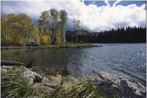
Miramonte Reservoir is located in San Miguel County about 10 miles south of Norwood in western Colorado. The reservoir is one of the most productive stillwater trout fisheries in the state and people travel from throughout the West to catch the rainbow and brown trout that regularly grow to quality size. The lake is also a popular destination for crayfish enthusiasts. Miramonte accounts for about 20,000 angler days every year which contributes $1.5 million to the economy of San Miguel County.
The illegal stocking of smallmouth bass has threatened the trout fishery and crayfish, as well as native fish downstream in the San Miguel and Dolores rivers, prompting action by Parks and Wildlife.
During the salvage anglers must have a 2013 Colorado fishing license and only hook and line methods of take will be permitted. The use of explosives, toxicants, firearms, seines, nets, snagging or electricity is prohibited. Signs will be placed at access points around the lake to notify anglers of this temporary regulation change.
“The trout fishing following ice-off around April 1 should be productive and anglers should take home good numbers of the pink-fleshed Miramonte trout,” Gardunio said.
As the reservoir is drained beginning in May, angler access may become difficult due to exposed mud flats. Boat access will be limited as ramps will eventually become unusable as the water level drops. Interested anglers are encouraged to utilize the fishery early in the year to avoid access issues later in the season.
This emergency salvage is a part of an effort by Parks and Wildlife to maximize angling opportunities in the short term while rebuilding the trout fishery at Miramonte as soon as possible.
“Treating the reservoir is something we wish we didn’t have to do, but we know we must,” said Renzo DelPiccolo, area wildlife manager in Montrose. “People who illegally move fish into lakes, ponds and rivers are not only committing a criminal act, they are endangering native species, stealing a resource and recreational opportunity from thousands of anglers and negatively impacting the local community.”
The chemical treatment, using Rotenone, is scheduled for early fall and the reservoir will be opened for fishing until that time. The date of the treatment will be announced late in the summer. During the treatment the reservoir will be closed for public safety. The reservoir will be drawn down and Rotenone will be applied to the remaining water and feeder streams to kill all of the fish. Rotenone breaks down quickly in the environment and poses no threat to vegetation or non-aquatic species.
Biologists will restock the lake with fish as soon as the pesticide has dissipated; a quick recovery of the trout and crayfish fisheries is expected.
“Miramonte is a very productive fishery where trout can grow ten inches or more in a single year,” Gardunio said. “We expect the catchable and sub-catchable trout we stock following the treatment to be up to quality size within a year of re-stocking.”
“This reservoir is managed as a put-and-grow trout fishery and that management strategy will not change,” explained John Alves, senior aquatic biologist for the southwest region for Colorado Parks and Wildlife. “Under this management strategy we can provide an excellent angling opportunity at a low cost to anglers.”
Smallmouth bass, which are a warmwater predator fish, were illegally stocked in the reservoir sometime before 2011 and reproduction has been documented. A recent survey showed that in one year smallmouth bass have increased in abundance from 5 percent to 44 percent of the fishery.
“The bass are now a top predator in the lake. They compete with trout for food and space, and consume trout and crayfish,” Alves said. “If left alone, the bass could eventually devastate Miramonte as a trout fishery. Furthermore, the habitat, prey base and water temperature will not support a quality bass fishery in the long term. So, once an illegally stocked fish population has become established, the only recourse is to start over by using a fish pesticide to kill all the fish in a lake.”
In addition to impacting a renowned sport fishery, the smallmouth bass also pose a threat to downstream native fish. An agreement between the state of Colorado, U.S. Fish and Wildlife Service and neighboring states restricts stocking of non-native warm water fish without a permit because of the danger they pose to native and endangered fish.
Miramonte Reservoir is located above the San Miguel and Dolores rivers which support important populations of three native fish species that biologists are working to protect: the roundtail chub, the bluehead sucker and the flannelmouth sucker. These native fish are found only in desert rivers of the western United States. Changes in the river system such as dams, pollution, water withdrawals, competition and predation from non-native species have caused these fish to decline in range and numbers.
“Native species are needed to help maintain the natural health and balance of any ecosystem. If a species is lost it affects the health of other plants and animals, and changes a natural ecosystem forever,” Alves said.
CPW aims to maintain healthy native fish populations not only for the benefit of native ecosystems and the people of Colorado, but also to prevent unwanted federal management of these species under the Endangered Species Act.
“Illegal stocking carries serious consequences that can have long-lasting negative effects on both fisheries and local communities,” DelPiccolo said.
Anyone who has information about illegal fish stocking at Miramonte Reservoir or at any other water in Colorado should contact the Parks and Wildlife office in Montrose at 970-252-6000, or call Operation Game Thief at 1-877-265-6648. Tips can be made anonymously and cash rewards are possible.
To read a full fisheries management report about Miramonte Reservoir, see: http://wildlife.state.co.us/SiteCollectionDocuments/DOW/Fishing/FisheryWaterSummaries/Summaries/Southwest/MiramonteReservoir.pdf.
For more information about fisheries management in Colorado and aquatic nuisance species, see: http://wildlife.state.co.us/FISHING/Pages/Fishing.aspx.


