

Glen Canyon Institute and the Great Basin Water Network. Courtesy of Utah Rivers Council
Click the link to read the article on the Aspen Public Radio website (Caroline Llanes). Here’s an excerpt:
April 21, 2026
The agency announced on April 17 that it would release between 600-thousand and one million acre feet of water from Flaming Gorge Reservoir on the Wyoming-Utah state line over the course of the next year. In addition, Reclamation will reduce the amount of water it sends from Lake Powell through Glen Canyon Dam, decreasing flows downstream through the Grand Canyon and into Lake Mead. Through September 2026, the agency will reduce its annual release volume from about 7.5 million acre feet of water to just 6 million acre feet.
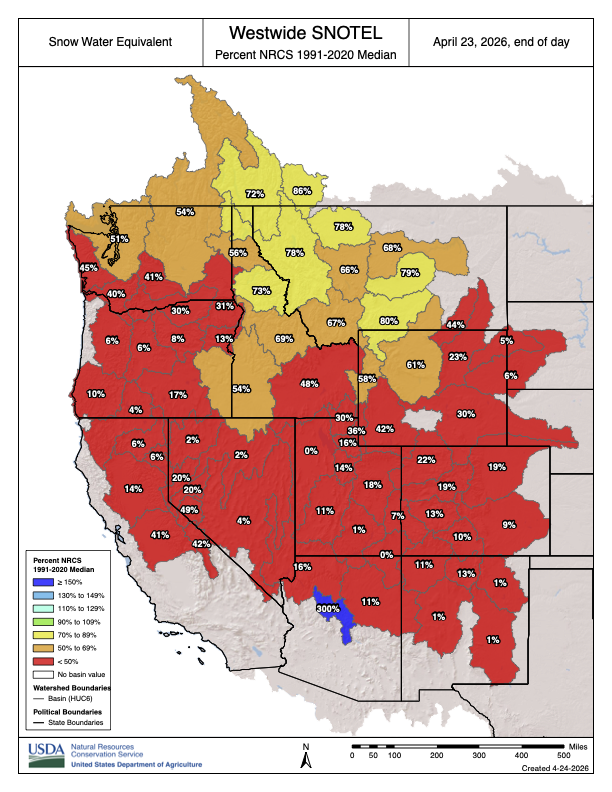
The drought contingency actions come in response to a water year that has been incredibly dire for the Western United States and the Colorado River Basin. Snowpack has been at record lows for much of the winter, which is bad news for a region that relies on snowmelt for much of its water use. The forecast for runoff into Lake Powell from the entire Upper Basin is forecast to be just 23% of normal. The agency estimates that these combined actions will boost Lake Powell’s elevation by 54 feet over the course of the year, bringing it to 3,500 feet in April 2027. Currently, Lake Powell’s elevation is about 3,528 feet. 3,490 feet is the elevation at which hydropower can no longer be produced at Glen Canyon Dam. Any lower, and water will not be able to enter the hydroelectric turbines. Instead, the water has to go through what’s called “river outlet works,” which are tunnels that bypass the turbines to get the water downstream to the Colorado River.

Seth Arens, a hydrologist at the Western Water Assessment, said Glen Canyon Dam was not designed to have the river outlet works as the primary way to get water out of the reservoir.
“When the Bureau of Reclamation has used those river outlet tubes, most of the times they’ve used them, there’ve been some damage to those tubes,” he said. “They’ve had to repair damages after relatively short uses, you know, a scale of weeks dumping water out of those.”
Environmental attorney Chris Winter said it’s clear Reclamation has to take emergency actions to protect its own infrastructure. But, he said the plan leaves a lot of uncertainty and unanswered questions.
“We’re not going to be able to release a whole bunch of water from Flaming Gorge Reservoir (next year) because that water will have been released this year, and it’s not going to refill if we get another dry year,” he said. “Releases of water from Upper Basin storage units, that’s like a one-time thing, unless we happen to get some wet years in the future.”

Flaming Gorge is currently about 82% full. Reclamation estimates that its plan will bring the reservoir down to about 59% of its full capacity over the next year. Other Upper Basin reservoirs are not part of the plan at the moment, due to poor forecasted inflows and low water levels. Blue Mesa Reservoir in Western Colorado is currently 47% full and Navajo Lake on the Colorado-New Mexico state line is 63% full. Winter said reducing flows out of Glen Canyon Dam could also lead to legal issues. The Upper Basin states of Colorado, Utah, Wyoming, and New Mexico have not reached a deal with the Lower Basin states of Arizona, California, and Nevada on how to allocate water—and take cuts to usage in the midst of a changing climate—over the next 20 years. On top of that, reducing flows this year would mark a fulcrum point: the first year that the amount of water at Lees Ferry, just below Glen Canyon Dam, falls below the averages set by the Colorado River Compact of 1922.
