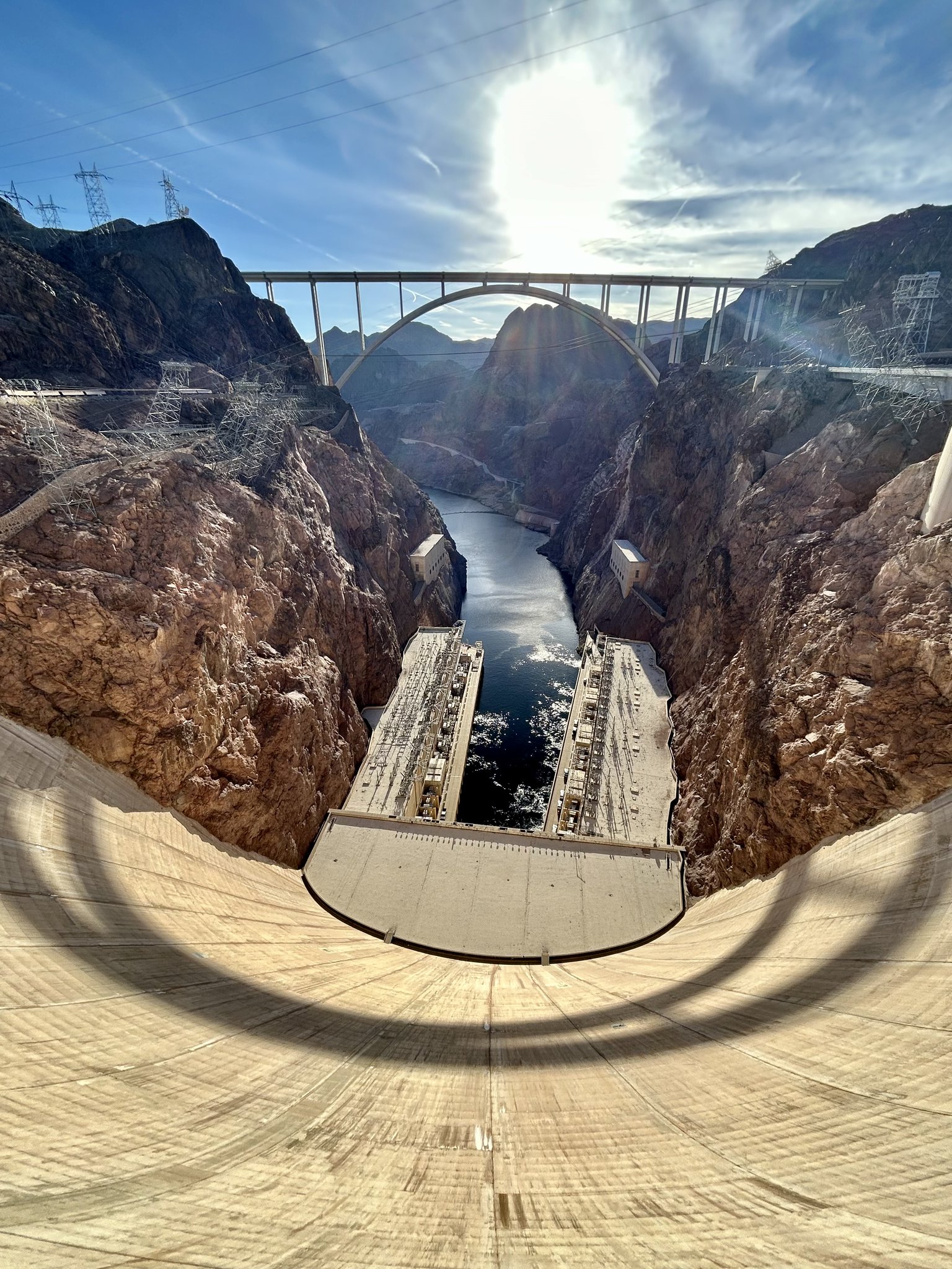
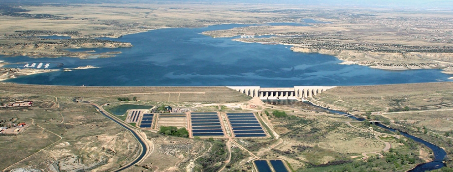
The Hoover Dam is a powerhouse! With an impressive output of about 3 billion kilowatt-hours of electricity annually, it provides enough energy to light up about 1 million households in Nevada, Arizona, and California, ensuring the lights stay on un the Southwest. Photo credit: USBR
Click the link to read the article on The Havasu News website (Alan Halaly). Here’s an excerpt:
May 1, 2026
In a Thursday joint statement, the Upper Colorado River Basin states of Colorado, Utah, New Mexico and Wyoming called for “immediate mediation” in the yearslong deadlock with the Lower Colorado River Basin states of Nevada, California and Arizona. They offered no details about who could fill that role or which entity would pay for the costs.
“Time is short, but structured negotiations through mediation offer a new path for authentic discussions,” New Mexico’s Upper Colorado River Commissioner Estevan López said in a statement. “Even at this late stage, we should pursue every opportunity to reach a workable agreement.”
[…]
Asked about how a mediator could differ from the federal government’s intervention or the appointment of a so-called “water master” at the U.S. Supreme Court, Entsminger said states are unlikely to view a mediator’s decision-making as binding.
“It’s certainly not litigation; it’s not even arbitration,” Entsminger said. “It’s more of a marriage counselor.”
[…]
Colorado River Board of California Chairman JB Hamby said in a Tuesday statement that his state proposed a mediation process last year. California officials see the need for both long- and short-term solutions, and mediation could push the Upper Basin toward “verifiable water contributions,” Hamby added.
“Effective mediation requires common ground, and the system cannot wait,” Hamby said. “Current conditions require immediate, measurable water reductions from every state.”
Map of the Colorado River drainage basin, created using USGS data. By Shannon1 Creative Commons Attribution-Share Alike 4.0
The initial fill of Chimney Hollow Reservoir has concluded, and the reservoir currently has about 1,500 acre-feet of water—less than 2 percent of the reservoir's full capacity of 90,000 acre-feet. Read more about the initial fill at https://t.co/WaxdbfiFWz. pic.twitter.com/ndlN3Y6zoV
— Chimney Hollow Reservoir (@ChimneyHollow) May 5, 2026
Frisco’s town manager can now implement water conservation measures outside of the standard triggers outlined in the town’s water code after an ordinance under consideration officially passed. Frisco Town Council approved Ordinance 26-10 on first reading at its April 14 meeting and adopted it on second reading at its April 28 meeting. The ordinance amends Article V of Chapter 171 in the town code to add the ability for the town to implement levels of its water restrictions if it’s determined that “significantly below-average snowpack” or “significantly above average temperatures” or a combination of these factors, both existing or anticipated, pose a risk to the town’s ability to provide water.
Prior to the amendment, the code used certain streamflow and water well storage levels to trigger levels of the water restrictions…A town meeting recap stated that “as of March 31, the North Ten Mile Creek watershed, which provides Frisco with much of its water,” had only roughly 7.3 inches of snow-water equivalent, which is about half as much liquid water stored in the snow compared to the five-year average.
“The 2025–2026 winter season produced historically low snowfall across the Rocky Mountain region, resulting in well-below-average snowpack levels that are critical to the Town of Frisco’s municipal water supply. Above-average spring temperatures have further exacerbated these conditions by accelerating snowmelt, increasing evapotranspiration, and driving higher wildfire conditions. These combined factors are significantly reducing available water supply at a time when seasonal demand will be increasing the Town’s daily water production by over 100%. Dillon Reservoir remains below historical storage levels, underscoring the vulnerability of the Town’s water resources and providing a real time visual reminder of just how limited the local hydrologic cycle is this year.”
Due to the historically low snowfall, which has led to the most severe drought designation by the U.S. Drought Monitor, town staff recommended moving from the current Phase 1 voluntary measures to Phase 3 mandatory restrictions, which limits “non-essential outdoor irrigation to two days per week in addition to other restrictions,” according to the town recap. Staff explained it’s possible that North Ten Mile Creek may run dry due to the current conditions and forecasts, which would require the town to rely on its wells, “which have been resilient even when the reservoir has been very low.”
The Bureau of Reclamation has adjusted the release schedule from Navajo Dam due to downstream maintenance activities. On Tuesday, May 5th at 4:00 AM, the release will increase from 450 to 500 cubic feet per second (cfs). A further increase to 550 cfs is planned for Thursday, May 7th at 4:00 AM.
Releases are made for the authorized purposes of the Navajo Unit, and to attempt to maintain a target base flow through the endangered fish critical habitat reach of the San Juan River (Farmington to Lake Powell). The San Juan River Basin Recovery Implementation Program recommends a target base flow of between 500 cfs and 1,000 cfs through the critical habitat area. The target base flow is calculated as the weekly average of gaged flows throughout the critical habitat area from Farmington to Lake Powell.
This scheduled release change is subject to changes in river flows and weather conditions. If you have any questions, please contact Conor Felletter (cfelletter@usbr.gov or 970-637-1985), or visit Reclamation’s Navajo Dam website at https://www.usbr.gov/uc/water/crsp/cs/nvd.html
The Colorado River flows through Las Colonias Park in Grand Junction, Colo. on April 22, 2026. The river reached an extremely low level due to heavy diversion upstream and record low snowpack. CREDIT: LUKE RUNYON/THE WATER DESK
With drought and high temperatures putting unprecedented pressure on water users throughout Colorado, from cities to agriculture, there’s one segment that can be affected first — and maybe worst — when it comes to a lack of water: rivers themselves and the ecosystems that depend on them.
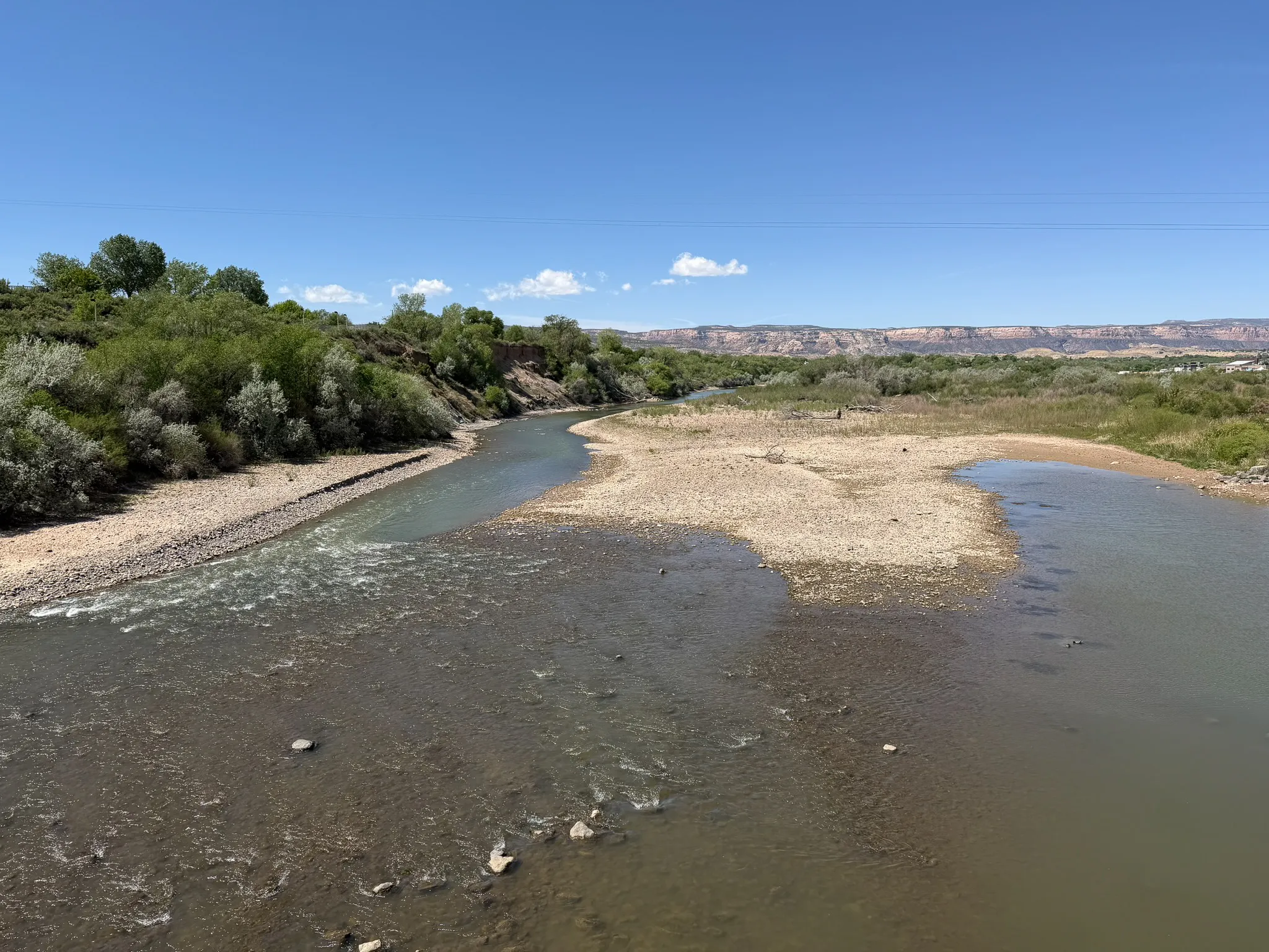
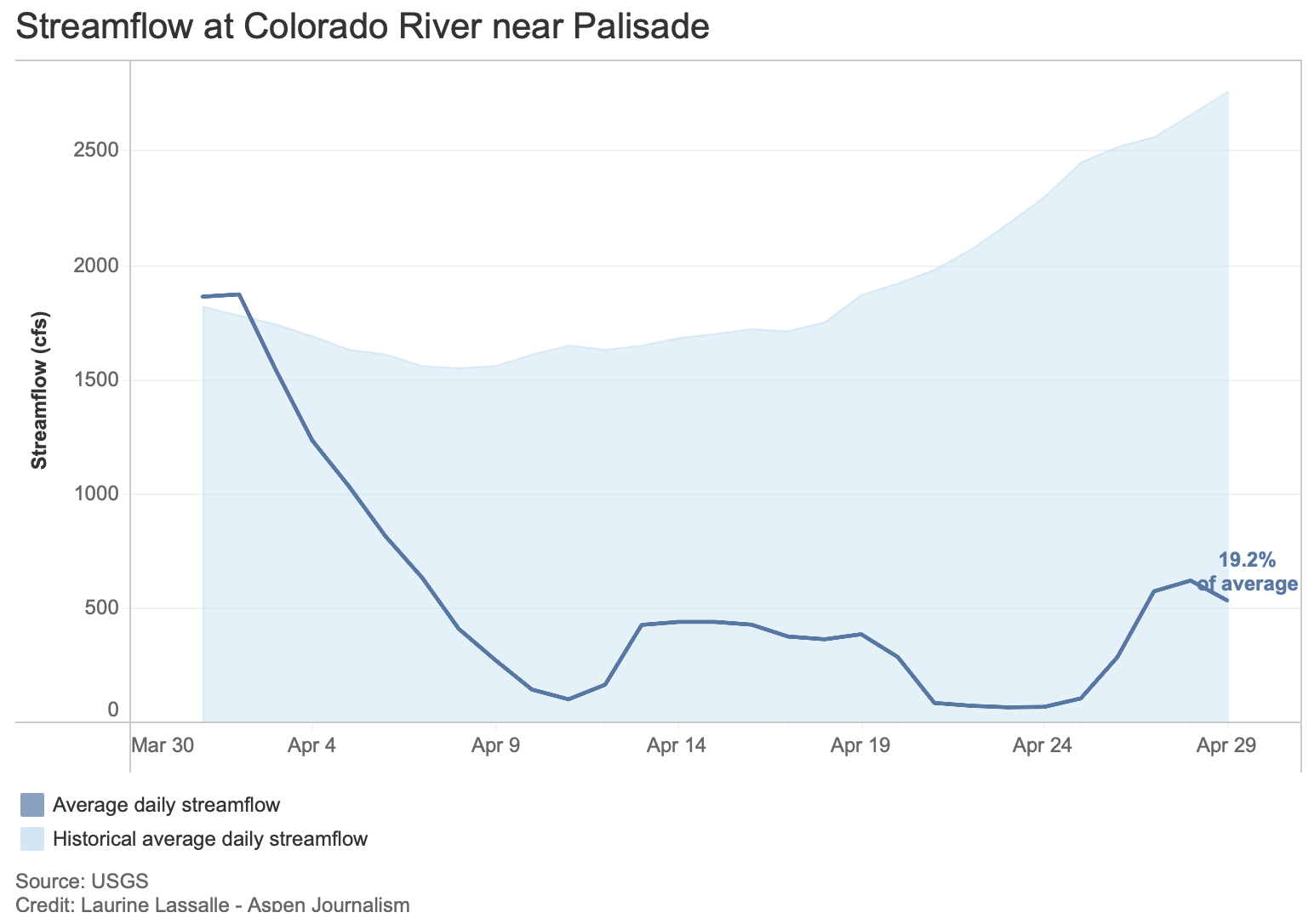
As cities enact water restrictions and farmers and ranchers prepare for the worst, impacts of the water shortage are readily apparent in a chronically dry stretch of the Colorado River between Palisade and the confluence of the Gunnison River that is critical habitat for endangered fish, known as the 15-mile reach.
The Upper Colorado River Endangered Fish Recovery Program works to return water to this stretch of river in the Grand Valley, but because of this year’s historically dry conditions, the program could have only 16,000 acre-feet, half its typical amount of water for fish.
Beyond that guaranteed amount, the program mostly uses water-sharing agreements that can secure additional acre-feet to boost flows — but only when other users don’t need the water and can voluntarily loan it. This year finds nearly everyone who depends on the Colorado River and its tributaries in dire straits.
Ruedi Reservoir, above Basalt, on the Fryingpan River, April 22, 2026. Photo: Brent Gardner-Smith
There won’t be any surplus water for fish in the Historic Users Pool, which is stored in Green Mountain Reservoir and is the largest source of water to potentially augment fish flows. A pool of water in Ruedi Reservoir that is available in four out of five years isn’t there, and the program could get only about 340 acre-feet from a pool in Wolford Reservoir upstream of Kremmling that typically has up to 6,000 acre-feet.
“It is really clear to me that we do not have enough tools in our toolbox to be able to manage for conditions like we have this year in the 15-mile reach,” said Julie Stahli, recovery program director. “We are so far outside the bounds of what we have ever seen before, that it’s really just hard to be able to make any good decisions.”
Stahli said she anticipates the program can contribute about 75 cubic feet per second through mid-July, at which point they will drop it down to 50 cfs, a bare-bones amount that is just enough to keep the riverbed wet.
This map shows the 15-mile reach of the Colorado River near Grand Junction, home to four species of endangered fish. Map credit: CWCB
“That is what we are anticipating being able to have for the entirety of the season in the 15-mile reach,” she said.
Side channels on the Colorado River ran dry early during spring runoff on April 22, 2026. Cobble bars and muddy banks emerged as the river receded near Dos Rios Park in Grand Junction, Colo. CREDIT: LUKE RUNYON/THE WATER DESK
As flows plummet, fish could become stranded in pools that are disconnected from the rest of the river, and program managers say they will try to prevent fish from using that stretch of river during times when flows are predicted to be at their lowest. Crews could use netting to keep fish out of the reach or close the flow of water that returns fish to the river after they accidentally enter an irrigation canal, which would keep them in the stretch of river above the diversion that has more water.
“Our main goal at this point is just to keep fish out of that reach,” Stahli said. “There is not a whole lot of attractive habitat in there right now for fish. Flows dropped so early in the season. We’re already seeing some pretty dire conditions in April.”
For several days in April, flows fell to just over 50 cfs, among the lowest levels in recorded history and far below the recovery program’s target flow for April in a dry year of 1,240 cfs. According to Stahli, the river’s flow at that low point could be solely attributed to recovery-program water that it had released from upstream reservoirs.
The goal of the recovery program when it was created in 1988 was to protect the humpback chub, razorback sucker, bonytail and Colorado pikeminnow, while also allowing the seemingly opposing goal of developing more water. An aim of the program was to allow farms and cities to continue using water and even expand their use without violating the Endangered Species Act.
Credit: The Land Desk
And the program has had some success, with one of the four species — the humpback chub — being downlisted from endangered to threatened in 2021. (The U.S. Fish and Wildlife Service has also proposed downlisting the razorback sucker.) These fish evolved over millions of years and are only found in the Colorado River basin. In today’s highly engineered and managed river ecosystem, they live mostly in just a few key locations in the Upper Basin, including the 15-mile reach, and in parts of the Yampa and Green rivers. Grand Junction’s minor league baseball team has adopted the charismatic fish as its team name and mascot; last year it was the humpback chubs, and now it’s the razorback suckers.
But the program has had trouble meeting target minimum flows in the 15-mile reach, even though upstream water development has not kept pace the way it was expected to. A main culprit is climate change, which has robbed the river of about 20% of its flows during the 21stcentury.
“We just don’t have the tools as a society to be able to handle what’s happening right now in any cohesive way,” Stahli said. “This isn’t an endangered fish problem; this is an everyone problem.”
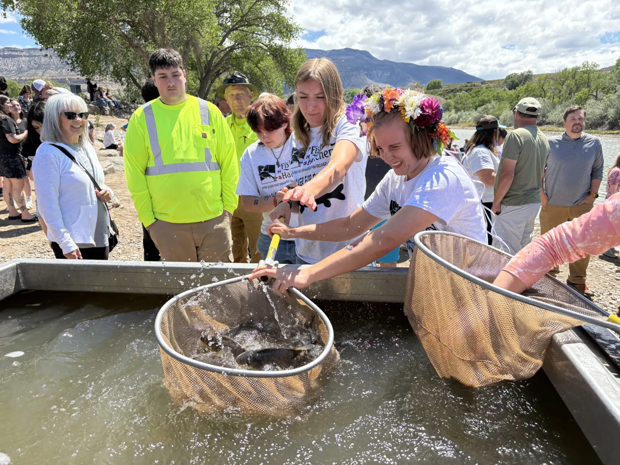
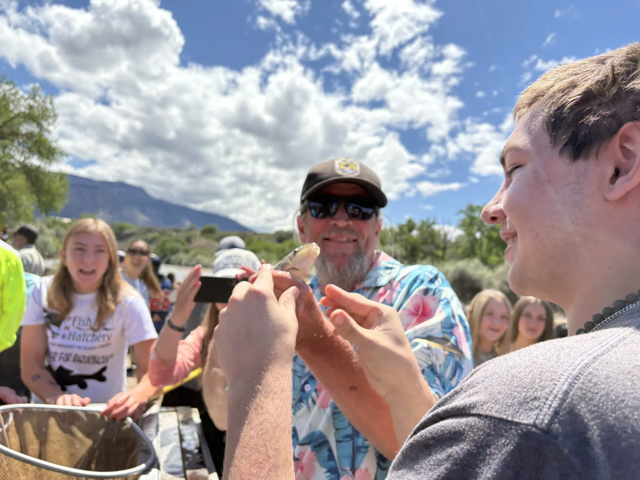
Palisade High School students released razorback suckers and bonytails they helped raise into the Colorado River on Friday, May 1. The two species live only in the Colorado River Basin and are endangered. CREDIT: HEATHER SACKETT/ASPEN JOURNALISM
Why is the river dry?
The reach is just downstream of large Grand Valley agricultural diversions, which are used to grow crops such as corn, alfalfa and the famous Palisade peaches, and which can take a combined 1,950 cfs from the river. At certain times of year, there can be more water in the Grand Valley’s canals than there is in the nearby Colorado River. Collectively, they are the biggest agricultural diversion from the Colorado River on the Western Slope.
“There has been so much diversion and damming of the river farther upstream,” said Bart Miller, healthy rivers director at environmental group Western Resource Advocates. “There are a lot of uses right there, and you’re seeing the impacts of all the Front Range diversions. [The 15-mile reach] is a pinch point in the system based on all the water development we’ve done.”
Water rights for the environment and recreation were latecomers to the legal system. It wasn’t until the 1970s — nearly 100 years after the most-senior agricultural rights on the Western Slope were established — that Colorado began protecting the value of water in streams with its instream flow program. Under Colorado’s system of water law, those who use water by taking it out of the river — including farmers, cities and industry — usually have the oldest rights, giving them first use of the resource. There’s nothing illegal about drying up a river.
“It’s like you’re running in a race and it’s four laps around the track,” Miller said. “The folks with the instream, recreational, environmental values are there at the starting line, but they’re held back for the first two or three laps. Everyone else is already running. And that’s why the environment often ends up in a really bad place.”
A Palisade High School student puckers up and prepares to kiss a fish goodbye on Friday, May 1 at Riverbend Park in Palisade. About 1,500 juvenile razorback suckers and bonytail, two species of endangered fish that students helped raise in a hatchery, were released into the 15-mile reach of the Colorado River. CREDIT: HEATHER SACKETT/ASPEN JOURNALISM
‘April hole’?
It’s not totally unheard of to have a small window of diminished streamflows in April. In a phenomenon known as the “April hole,” irrigation demands in the Grand Valley ramp up, while the needed water remains frozen solid as high-country snowpack. This problem remedies itself within a couple weeks as the snow begins melting. But this year, little snowpack remained by April and water managers think spring runoff at Cameo, where the big Grand Valley diversions are located, peaked during the March heatwave.
Kate Ryan is executive director of the Colorado Water Trust, which works to put water back into streams through temporary water sharing agreements with agricultural, municipal and industrial water users. Although the Water Trust is still finalizing contracts for this year, Ryan said she expects the Water Trust to add about 4,700 acre-feet of water to the 15-mile reach by leasing water from Ruedi Reservoir owned by the town of Palisade, and oil-and-gas company QB Energy.
In past years, water from this project has been released between the end of July and beginning of October. But that timing may change if the recovery program is trying to keep fish out of the reach.
“We will make sure that we deliver water at a point that complements the work of the recovery program,” Ryan said.
The Water Trust has also used the Colorado River Water Conservation District’s water marketing program — where acre-feet are available for purchase — to restore water to streams. But the River District board at its April meeting voted to freeze all new contracts, which are usually doled out first come, first served, while staff figures out the best use of the limited water supply.
The move was part of a series of drought mitigation actions aimed at easing shortages for water users. The board last month also approved a system for prioritizing water sectors, with keeping water in rivers at the bottom of the list: municipal and domestic water needs over agricultural and industrial needs; and agricultural and industrial needs over in-channel uses such as those that benefit the environment, endangered fish and recreation.
The Water Trust this week sent a letter to some water managers recognizing the historic drought and acknowledging that many of its temporary water sharing agreements, which pay water rights holders to leave water in streams, may not operate this year because their agricultural partners may not have enough water for their own use. Projects are voluntary and happen only in years when participants have enough water to share and it can benefit a stream.
But the letter also said there may be others who are interested in using their water rights to help prop up a stream this year.
“There is just so much uncertainty right now that we are trying to be as flexible and responsive as possible,” Ryan said.
Palisade High School students released two species of endangered fish into the Colorado River on Friday, May 1, 2026. Target flows for these fish in the 15-mile reach are often not met. CREDIT: HEATHER SACKETT/ASPEN JOURNALISM
Recovery-program officials said this year they will double down on other actions that benefit endangered fish, including removing nonnative predator species such as smallmouth bass and stocking the river with hatchery-raised fish. On Friday, students at Palisade High School released 1,500 young razorback suckers and bonytails that they helped raise into the Colorado River at Riverbend Park in Palisade.
Recovery-program staff said managing the 15-mile reach this year is about preventing the worst impacts and seeing what lessons can be learned from one of the driest years on record.
“It is just new terrain,” said David Graf, instream flow coordinator for the recovery program. “I think we are just flying by the seat of our pants in a lot of ways trying to do triage management as opposed to really adapt.”
For now, one of the few ways to add water back to a depleted river remains borrowing it from other, more senior users.
“I think until our water suppliers and state government hear from people that the environment really is a priority, not just the recovery program and need to support endangered species, but also for communities and local economies across the board, it’s going to stay that way,” Ryan said.
Bicycling the Colorado National Monument, Grand Valley in the distance via Colorado.com
If someone were to be dropped from another planet into the North Fork Valley in western Colorado today, they would be forgiven for assuming there is not a water crisis. A thick carpet of green covers the valley floor, the irrigation canals are filled to the brim, trees are leafing out, the river is running and Paonia Reservoir is almost full, and the mountains are still graced with snow.
I didn’t even come from outer space — I think — and I find the contrast between the news reports of water shortages and restrictions and the on-the-ground situation here to be quite jarring. Is it possible that April precipitation has averted the calamity?
A green hay field on a mesa in the North Fork Valley in western Colorado. Jonathan P. Thompson photo.
Yes, a series of storms, some quite abundant, have moved through the Upper Colorado River Basin, boosting snowpack and soothing the desiccated earth. It has certainly felt cooler and wetter than normal, but that was mostly an illusion brought on by the abnormally dry winter and the searing March heatwave. And it hasn’t been nearly enough to offset the warm winter and the lack of snow, as the graphs below indicate.
As for the full ditches, I guess you could attribute that to a “make hay while the water is available” sort of ethos. You might as well douse the fields and fill ponds while spring runoff is in full swing and the river still runs, knowing that it may not last beyond June. Meanwhile, Paonia Reservoir’s relatively healthy levels are the result of the Fire Mountain irrigation canal — which relies on reservoir water — being shut down for emergency repairs.
Meanwhile, there is a conspicuous absence here in this agricultural hotspot: There are no blossoms or fruit on apple, cherry, peach, or pear trees. The March heatwave sparked a spectacular orchard super-bloom. That was followed by a devastating freeze that killed all of the fruit, even in orchards where extreme preventative measures were taken, and even “burned” the leaves on some trees. Wacky weather indeed.
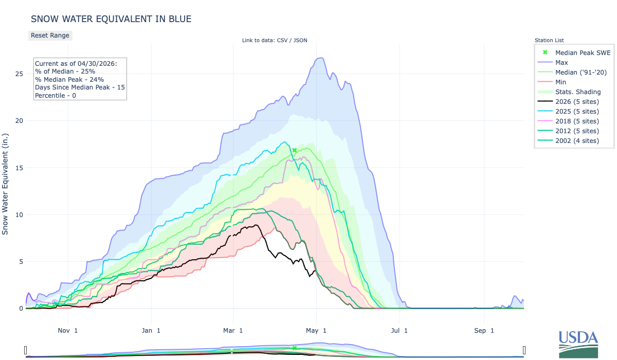
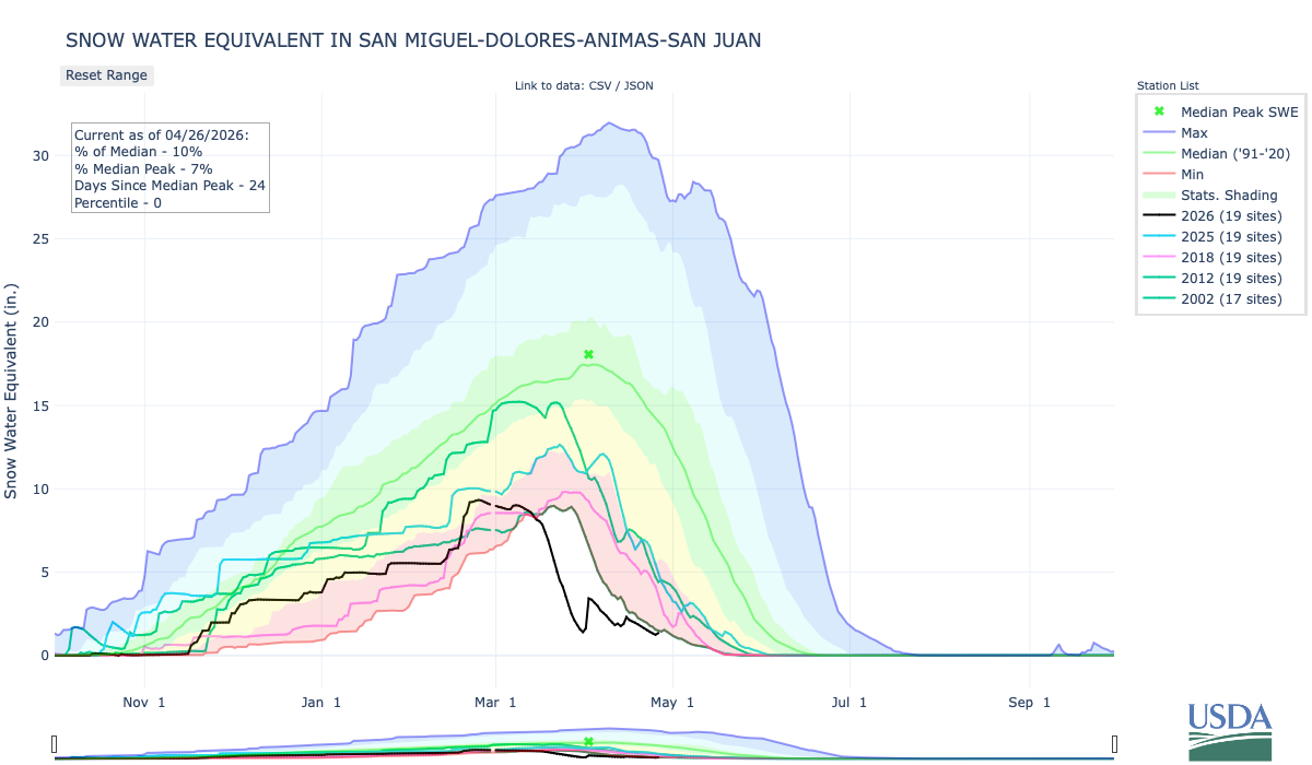
The North Fork of the Gunnison’s May 1 snowpack this year is tied for the lowest on record with 2012.
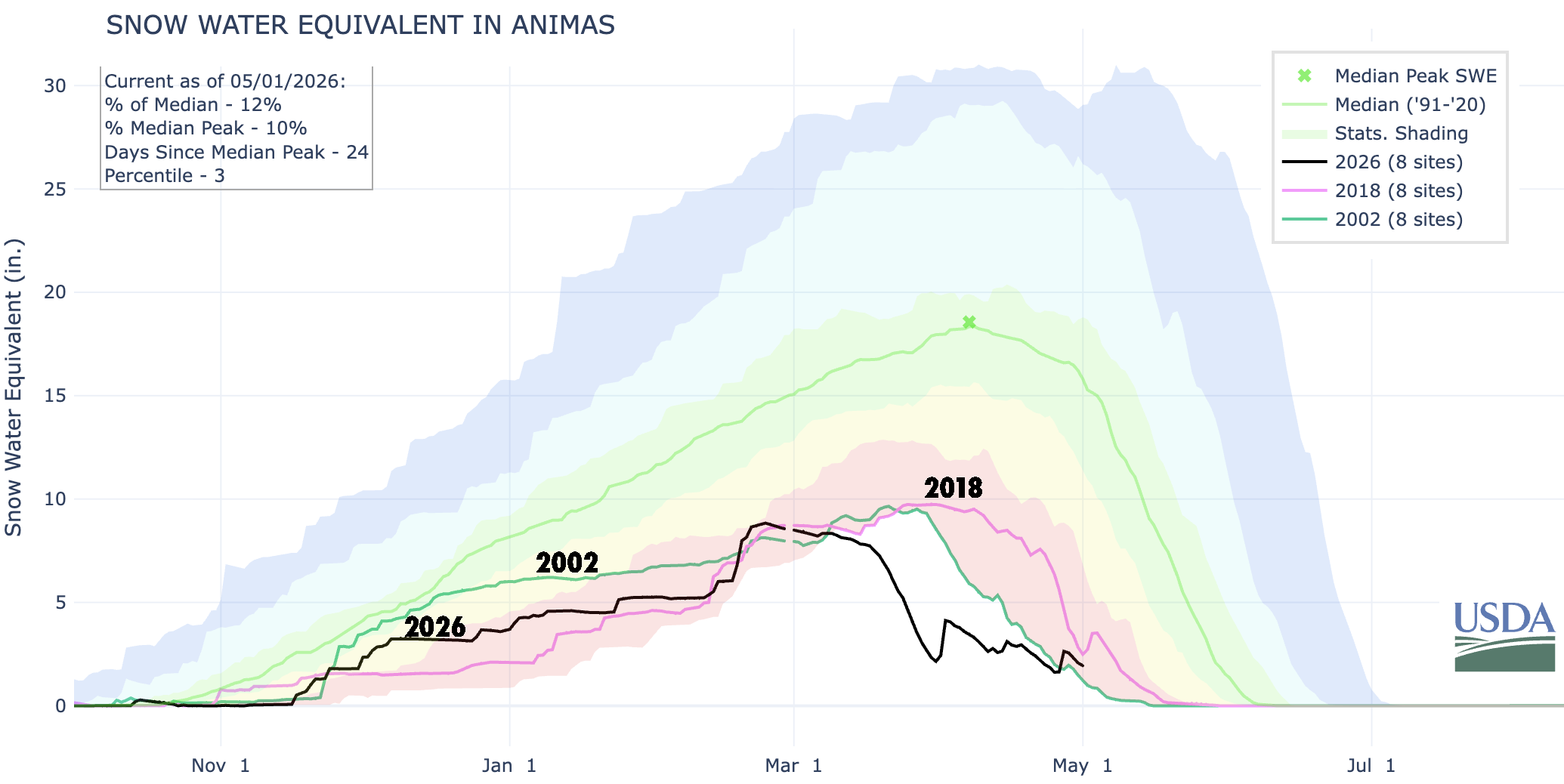
The Animas River watershed did get enough of a boost to bring snowpack levels back up above 2002’s for this date. Source: NRCS.
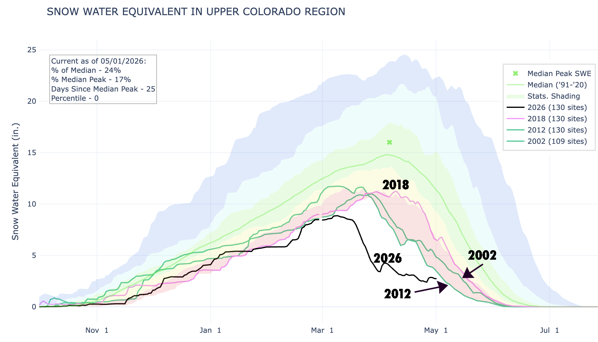
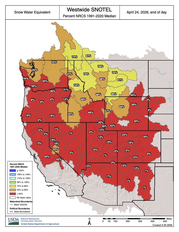
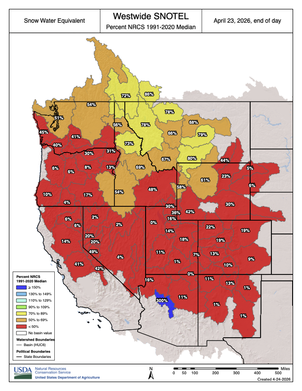
Even with the recent storms, the Upper Colorado River Basin snowpack remained at record-low levels as of May 1. The previous low year (from 40 years of SNOTEL records) was 2012, with 2002 and 2018 not far behind. Source: NRCS.
🐟 Colorado River Chronicles 💧
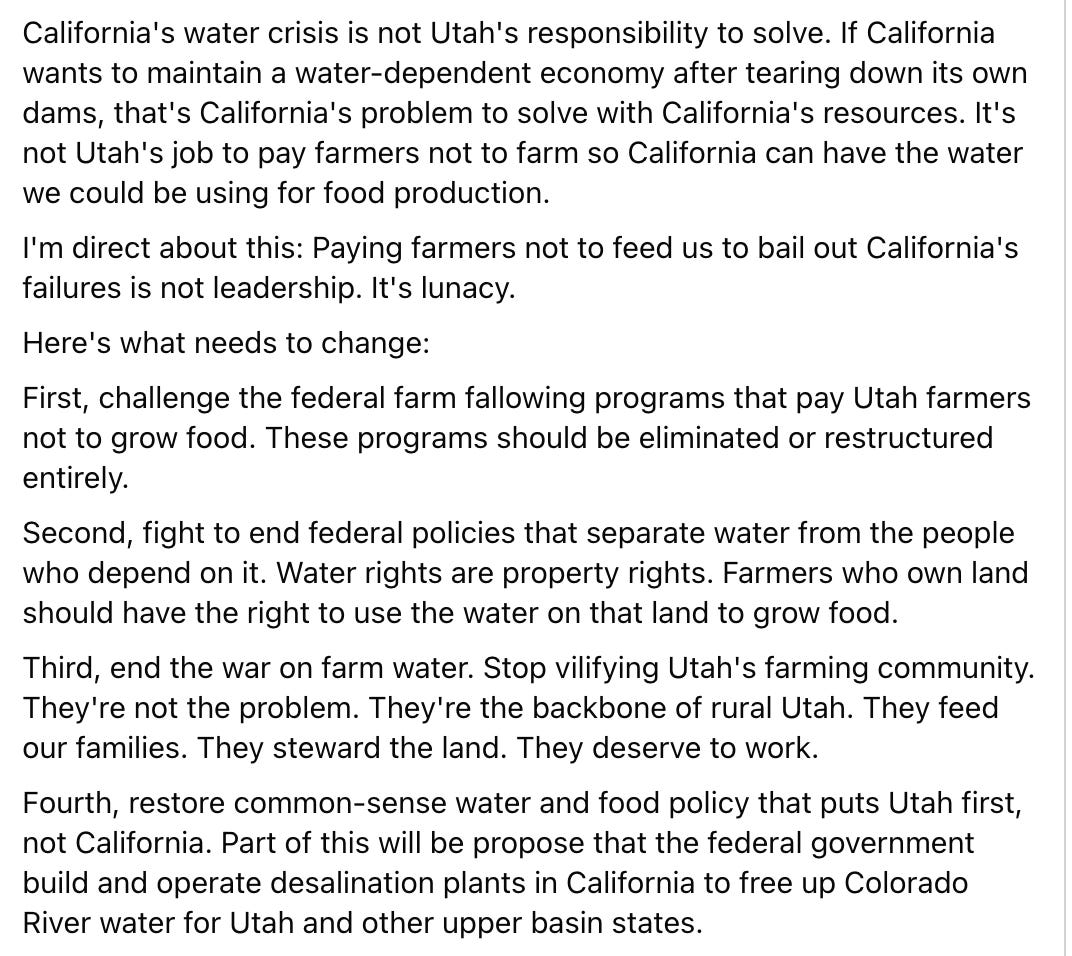
Phil Lyman, the former and hopeful Utah politician, recently posted this on Facebook:
Just to sum it up: He’s knocking a federal program that pays willing farmers to voluntarily cut off irrigation to their fields in order to conserve water in an effort to balance Colorado River demand with the shrinking supplies. And he’s blaming it all on California.
Lyman’s general sentiment is not new, nor is it uncommon among water users in the Upper Basin states. In fact, it’s basically a cliché. Since I was a kid I’ve heard folks saying something along the lines of: If we don’t use the water, it’ll just run on down to California, where those L.A. folks will guzzle it up to fill their swimming pools and water their golf courses. It’s a rather simplistic view, and one that doesn’t account for the realities of water law or the way the Colorado River system works. In other words, it’s just plain wrong, and a candidate for Congress — as Lyman is — should know better.
Udall/Overpeck 4-panel Figure Colorado River temperature/precipitation/natural flows with trend. Lake Mead and Lake Powell storage. Updated through Water Year 2025. Note the tiny points on the annual data so that you can flyspeck the individual years. Credit: Brad Udall
The Colorado River and its users have a problem: Demand for the water exceeds supply, and the supply is continually shrinking. Since boosting supply is not a feasible option, demand — i.e. consumptive use — must be reduced significantly. While everyone must make cuts, agriculture is the river’s largest water user by far, meaning that sector is going to have to make the largest cuts, by volume. This isn’t about demonizing farmers or alfalfa, it’s not about whether Californians or Utahns are more deserving of the water. It’s simple math.
The farm fallowing program is one way to cut consumption quickly by paying willing farmers to voluntarily forego irrigating some or all of their fields on a year-by-year basis. It’s not ideal, but it is legal, voluntary, and can save junior water rights holders, including cities and towns throughout the watershed, from being forced to shut off their water intakes. And in no way is farm fallowing exclusive to Utah. It’s occurring all over the place.
Let’s do a little fact-check of Lyman’s other points:
Farm fallowing in Utah is being done to benefit California, which “demolished its water storage infrastructure.” No and no. The goal here is to leave a little more water in the river, to keep the whole system from collapsing. Any amount conserved in one place will potentially benefit all other river users, as well as the river itself. Foregoing irrigation on a Utah farm, for example, could help keep the taps on in St. George or some other Utah community that relies on the river. Dams have been removed in California, most significantly four structures on the Lower Klamath River. But those were primarily for hydropower production, not irrigation or water storage, and they are far removed from the Colorado River or any associated water storage.
“Paying farmers not to feed us to bail out California’s failures …” Actually, the feds and state and other programs mostly are paying farmers not to grow alfalfa or hay, which feed cattle, and it has nothing to do with California’s “failures.” Indeed, California grows a lot of alfalfa, too, but it also grows all kinds of vegetables — far more than in Utah.
If the water saved in Utah does make it to the Lower Basin and California, then the biggest beneficiary would be … farmers. Most of the water in the Lower Basin goes to the Imperial Irrigation District, where it is used for farming. Those farmers have also been part of the federal fallowing program, and have managed collectively to reduced their Colorado River water consumption by about nearly 1 million acre-feet since 2003.
Lyman calls for eliminating or restructuring federal farm fallowing programs. I’m curious if he’s talked to the farmers about this, especially the ones who may lose their water and be forced to fallow anyway. Isn’t it better to get paid not to grow something than to not get paid for it?
“… fight to end federal policies that separate water from the people who depend on it. Water rights are property rights.” We all depend on water; the California farmers depend on water just as much as Utah farmers do. Furthermore, the California farmers also own their land, they have some of the most senior water rights on the Colorado River, and according to the “Law of the River,” they could likely go to court to force many Utah farmers to stop irrigating altogether, without compensation. The farm fallowing program does not separate water from the farmers, it simply pays them to temporarily forego irrigation.
“… end the war on farm water.” Look, there is not enough water in the Colorado River for everyone. Everyone will have to take cuts, but irrigated agriculture is the biggest user by far, and therefore will have to make cuts in order to balance supply and demand. It’s simple math: All of Las Vegas and southern Nevada use less than one-tenth of the water that goes to the farms in the Imperial Irrigation District.
“… propose that the federal government build and operate desalination plants in California to free up Colorado River water for Utah …” Desalination will likely be a part of the West’s water future, especially for coastal urban areas. But building the plants, and processing and transporting these kinds of volumes of water, would be outrageously expensive and energy-intensive, which would be especially harmful to farmers, who rely on cheap water.
***
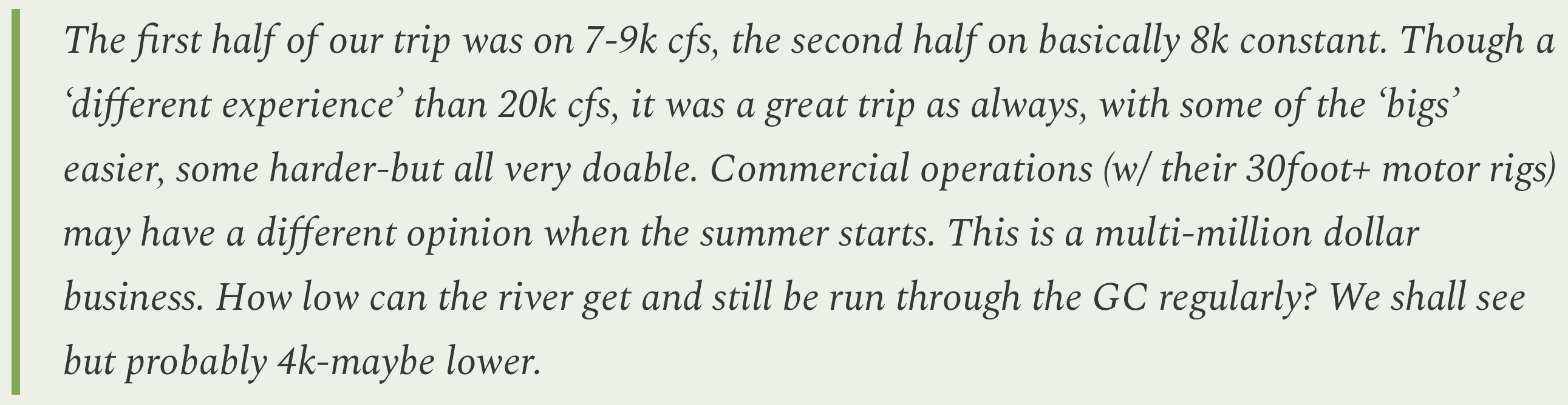
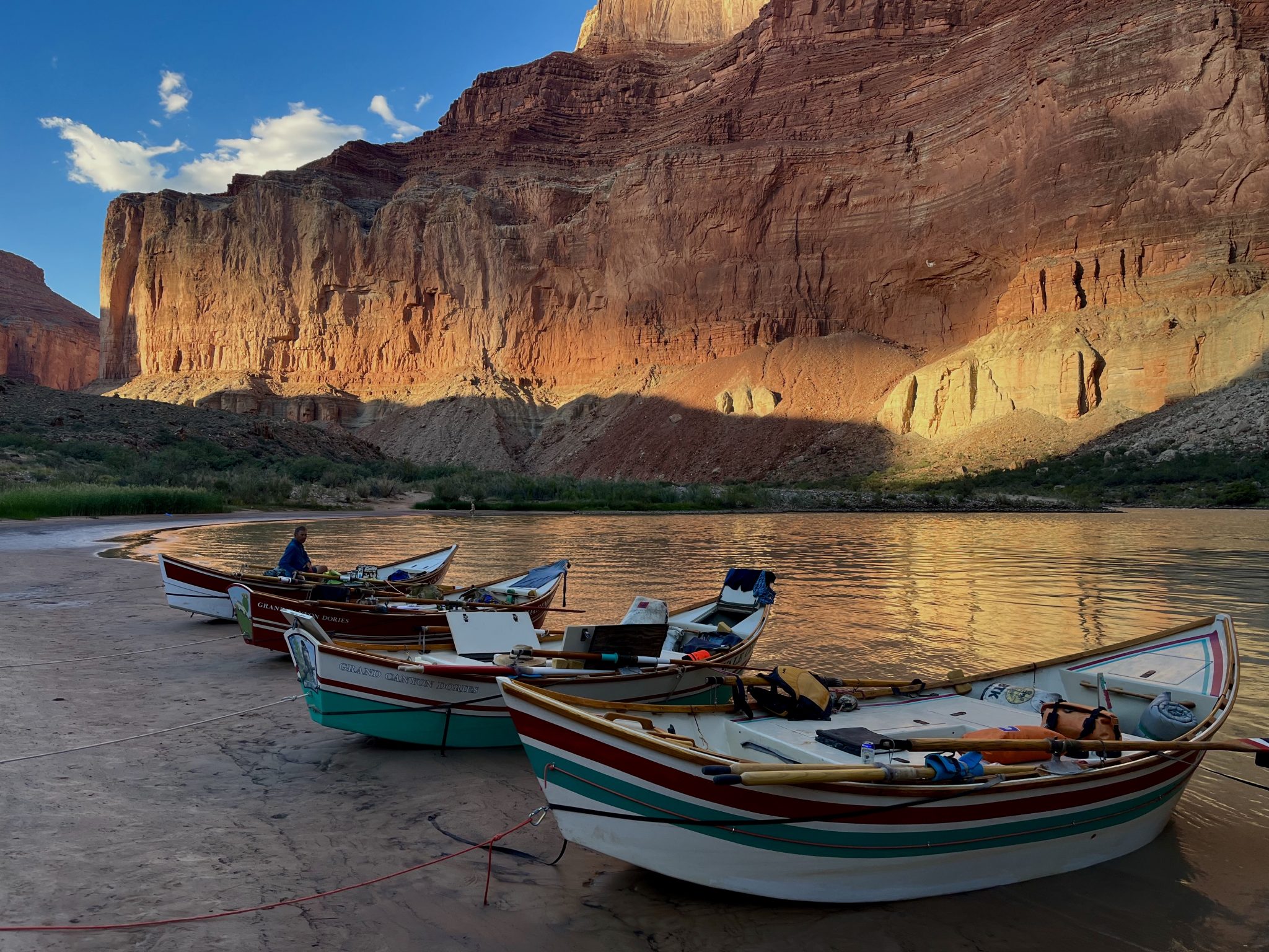
The Bureau of Reclamation recently decreased Glen Canyon Dam releases from about 8,200 cfs to a steady 7,000 cfs (without the usual nighttime reductions). This appears to be the lowest sustained releases since the dam was built, and if continued throughout the entire year would lead to only 5 million acre-feet of annual releases, which would make the Lower Basin states even more grumpy and litigation-happy than they already are.
But not to worry, the feds are still on course to release 6 MAF for the water year, because they released about 10,000 cfs during January and February. Still, it’s going to change the complexion of rafting in the Grand Canyon, for sure, and it is certainly pushing the boundaries of the Grand Canyon Protection Act.
📸 Parting Shot 🎞️
Snow falls on the Abajo Mountains in southeastern Utah as seen from near Dove Creek, Colorado. Jonathan P. Thompson photo.
Udall/Overpeck 4-panel Figure Colorado River temperature/precipitation/natural flows with trend. Lake Mead and Lake Powell storage. Updated through Water Year 2025. Note the tiny points on the annual data so that you can flyspeck the individual years. Credit: Brad Udall
The Lower Basin States of Arizona, California, and Nevada today advanced a plan to stabilize the Colorado River through 2028, responding to declining reservoir levels, record low inflows to Lake Powell, and increasing risk of reaching critical elevations at both Lake Powell and Lake Mead.
Earlier in the post-2026 process, the Lower Basin took a significant step by proposing 1.25 million acre-feet in annual reductions, with an additional 250,000 acre-feet from Mexico, totaling approximately 1.5 million acre-feet per year.
This proposal builds on that foundation with an expanded system conservation program across the Lower Basin with an estimated contribution of at least 700,000 acre-feet. In total, the plan identifies up to 3.2 million acre-feet of water savings to the system through 2028.
The proposal is an integrated package addressing Lake Powell releases, Upper Initial Unit operations, Lower Basin reductions, additional conservation, use of Intentionally Created Surplus, and system infrastructure improvements. Lower Basin contributions are contingent on these coordinated operations to ensure system stability as well as appropriate funding.
“With this proposal, the Lower Basin is putting forth real action to stabilize water supply along the Colorado River. We’re putting forward additional measurable water contributions for the system. Without that, the system will continue to decline,” said JB Hamby
“This proposal is about moving from ideas to implementation,” said John Entsminger. “It pairs real measurable water contributions with sensible dry-condition operations at Lake Powell and across the Upper Initial Units. Now is the time for every water user in the Basin to double down on water conservation as we face historically dry hydrology.”
“This proposal reflects the creativity and commitment of water users across the Lower Basin who continue to step forward with solutions that support the river,” said Tom Buschatzke. “We have shown that collaborative, voluntary efforts and reductions that are certain can produce meaningful water savings.”
The Lower Basin states recognize the Upper Basin’s call for mediation and are open to that process. However, current conditions require immediate, measurable water reductions from every state. The Lower Basin states stand ready to engage in a meaningful process for long-term solutions while encouraging the Upper Basin to step forward now with verifiable water contributions to help stabilize the system and support a near-term, seven-state bridge.
The Lower Basin states confirmed that the proposal preserves legal accountability under the Colorado River Compact, including Upper Basin delivery obligations, while maintaining a clear path toward a broader agreement among all seven Basin States.
The plan has been advanced to the federal government for consideration as part of the ongoing post-2026 planning process and is intended to provide a near-term bridge through 2028 while long-term operating guidelines are finalized.
Implementation of key elements of the proposal, including expanded system conservation, will require federal partnership. The proposal remains subject to approval by the Arizona Legislature and relevant California and Nevada water agency governing boards.
Colorado River. Photo credit: Central Arizona Project
May 1, 2026
The situation on the Colorado River is dire. Flows have reached historic lows and water saved in major storage reservoirs is approaching critical elevations. To date, solutions to the crisis have been elusive, with lengthy litigation looming as the seven states that share the river have been unable to agree on an appropriate remedy to the situation. That is why today’s announcement that the Lower Division States of Arizona, California and Nevada have come together to announce a bridge proposal that will support the entire Colorado River system through 2028 represents a welcome lifeline and cause for hope. This three-state proposal is a two-year, comprehensive package that will commit a minimum of 3.2 million acre-feet of Lower Division water savings in Lake Mead by 2028
The proposal is a bridge, a pathway to future operations that extend beyond the expiration of the existing river operating guidelines at the end of 2026. However, this massive sacrifice by the Lower Division States is only possible by implementing the entire proposal, which requires a series of critical actions by the federal government. The federal government must commit the remainder of Colorado River drought funding to offset impacts to Lower Division users, create a tribal pool to meet federal responsibilities to tribal communities, and use the reservoirs upstream of Lake Mead for their foundational purpose — meeting water delivery obligations to the Lower Division. Congress built those upstream dams for the purpose of releasing water and meeting minimum obligations to the Lower Division under the Colorado River Compact during an extended drought like the one we face today and now, the dams must be used as mandated by Congress.
Today’s announcement is the latest in a series of actions by the Lower Division States to preserve the stability of the Colorado River system. Lake Mead would be in the mud if not for Lower Division water users leaving water in the lake to protect the system, and every drop that has been left in Lake Mead is benefiting Lake Powell and the Upper Division by allowing for less water to be released downstream.
But Lower Division actions alone cannot protect the entire system from extraordinarily dry years. This year is an example where, despite the Lower Division’s ongoing reductions and contributions, Lake Powell needed additional emergency action.
While this new Lower Division bridge requires no action from the Upper Division states, it is well past time that the Upper Division States agree to be part of the solution by committing to verifiably conserve water and end their out-of-touch demand that the Upper Division be allowed to increase their total uses from a shrinking system.
The Central Arizona Project applauds the Lower Division States for developing the proposal and urges the federal government to speedily approve this emergency effort to bridge the river system through 2028.
Breckenridge Town Council approved more stringent water restrictions, limiting outdoor watering to two days per week, as town officials respond to drought conditions and declining streamflows in the Blue River. The new Stage 2 restrictions come as the town faces a water shortage tied to this year’s historically low snowpack and reduced runoff into Goose Pasture Tarn, according to Shannon Cahill, town engineer. The restrictions officially take effect on Friday, May 1.
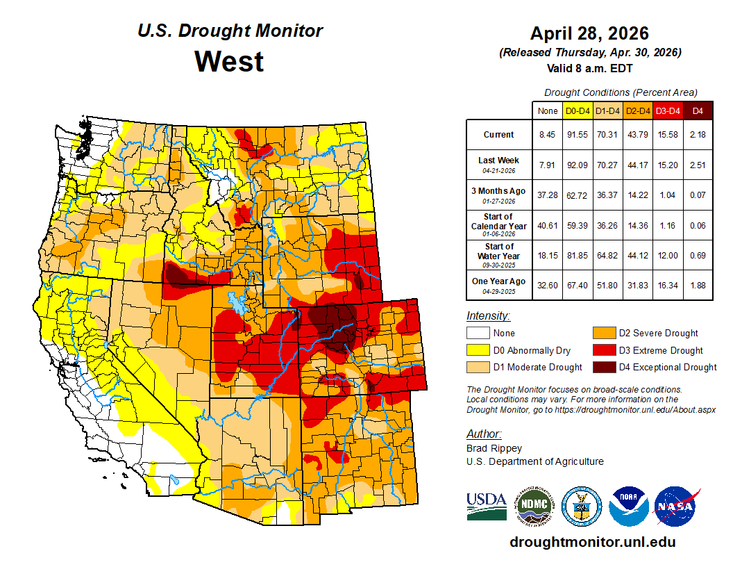
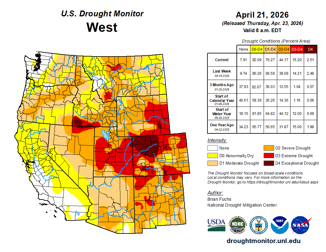
West Drought Monitor map April 28, 2026.
“We remain in a sphere of drought here in Summit County, throughout the state and the greater Western U.S.,” Cahill told council members at a meeting Tuesday, April 29. “The historically low snowpack has already directly impacted streamflow in the Blue River, and this subsequently affects the town’s ability to supply treated water to our customers.”
Until this week, Breckenridge allowed outdoor watering three days per week. The new temporary restrictions reduce that to two days in hopes of cutting outdoor water usage by roughly 30%. The town largely sources its drinking water from snowmelt (and other high-altitude surface water) collected in the Blue River Basin…The new restrictions exempt any newly installed landscaping, along with hand watering and drip irrigation for flowers and plants. Council member Dick Carleton clarified whether downtown businesses could continue watering flower baskets and using microsprayers.
…as the city gears up for an unprecedentedly dry summer, it will begin ramping up enforcement on water users who violate the stage 2 water restrictions. That will include issuing formal notices of violation and collecting fines for repeat violations.
“We are taking this year more seriously, given that it’s conditions we haven’t quite seen before,” Loughlin Molliconi said. “We want to make sure we can prioritize the most important uses of municipal water without having to degrade any environmental protections or streamflow.”
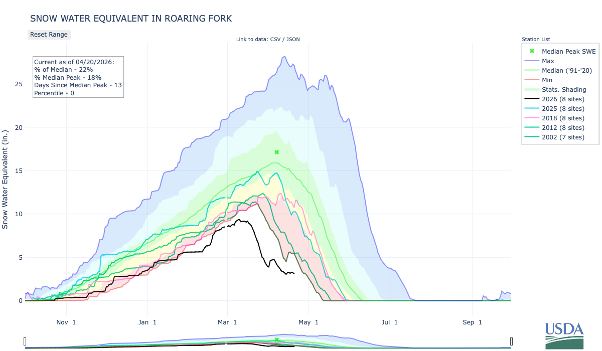
The city water department has issued 11 formal notices of water use violations in 2026, Loughlin Molliconi said. One notice was issued last week. Ten were issued on Wednesday. They were all first-time violations, which don’t come with fines…Aspen City Council declared a stage 2 water shortage last August after declaring a stage 1 water shortage in June. The declaration came after a lackluster monsoon season, and has remained in place because of unusually high winter temperatures that impacted snowfall accumulations and the snow water equivalent in the Roaring Fork watershed. Stage 2 water restrictions are mandatory. Watering of any lawn, garden, landscaped area, tree, shrub or other plant is prohibited from 9 a.m. to 6 p.m. Household watering schedules are also mandatory.
This story was produced by Circle of Blue, in partnership with The Water Desk at the University of Colorado Boulder’s Center for Environmental Journalism.
KEY POINTS
Glen Canyon Dam, completed in 1963, was not designed to be operated at extremely low water levels in Lake Powell.
The decline of Lake Powell is putting hydropower generation and downstream water deliveries at risk.
The Bureau of Reclamation, the federal water manager, is studying options for retrofitting Glen Canyon Dam.
In the span of U.S. history certain years are turning points, milestones in the nation’s story. 1776. 1865. 1929. 1968. Circumstance and consequence conspire to make it so.
For the Colorado River and those who rely on it, 2026 is on the verge of similar prominence. Circumstances in the basin today are that urgent.
Udall/Overpeck 4-panel Figure Colorado River temperature/precipitation/natural flows with trend. Lake Mead and Lake Powell storage. Updated through Water Year 2025. Note the tiny points on the annual data so that you can flyspeck the individual years. Credit: Brad Udall
A slow-developing water supply calamity, decades in the making, has boiled over, like a cold war turning hot. Extreme heat in March – triple-digit temperatures never witnessed that early in the year – obliterated a meager snowpack. The basin’s big reservoirs, the supposed buffers against short-term drought, were already uncomfortably low after a quarter-century of declining river flows. They will drop even lower. The amount of water flowing this summer into Lake Powell, the nation’s second-largest reservoir, will be one of the smallest ever measured, barely a trickle.
“This is unprecedented, but it’s not unpredicted,” said Eric Balken, executive director of the Glen Canyon Institute. “I like to say that this is the most predicted disaster of all time.”
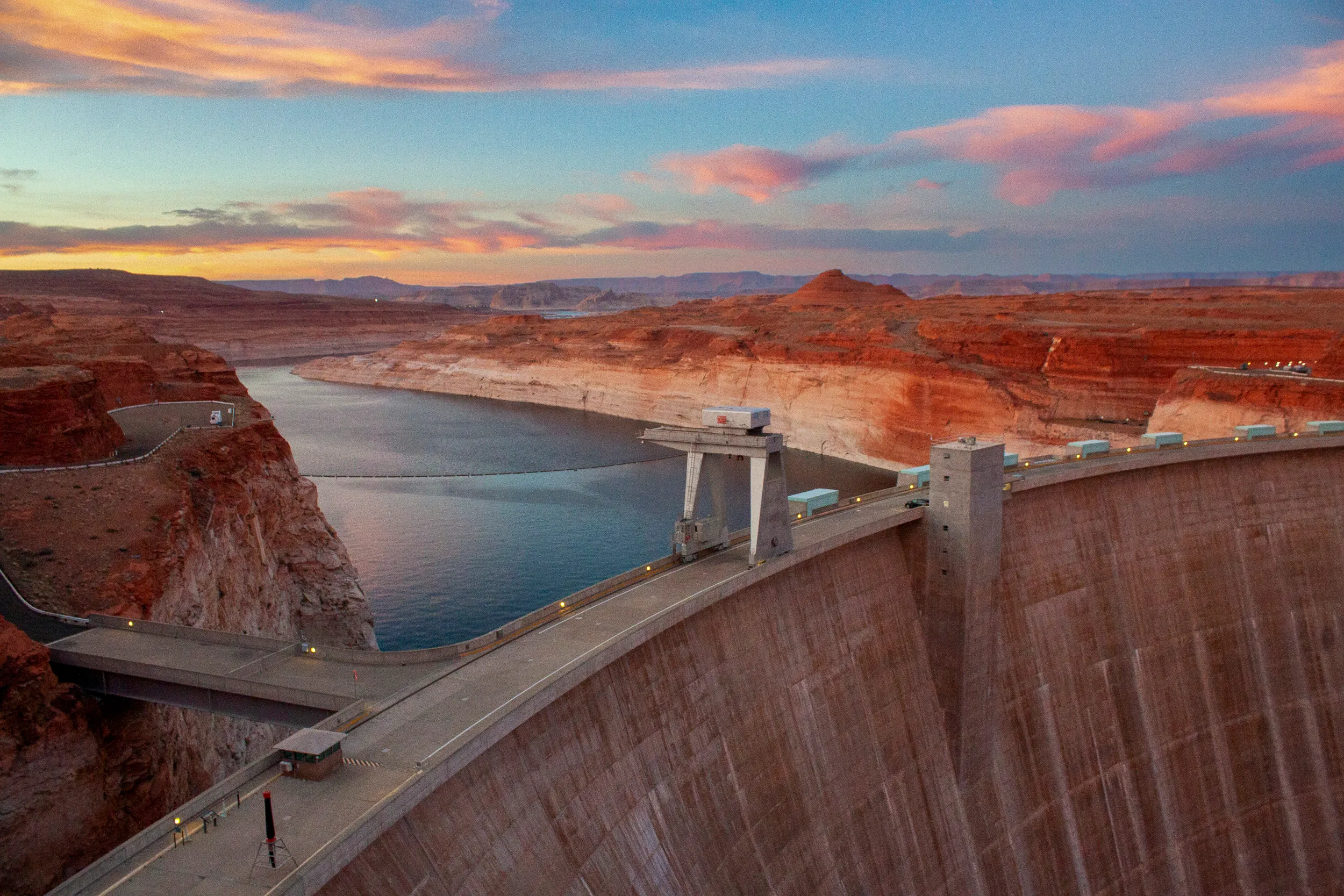
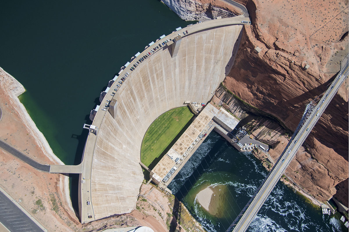
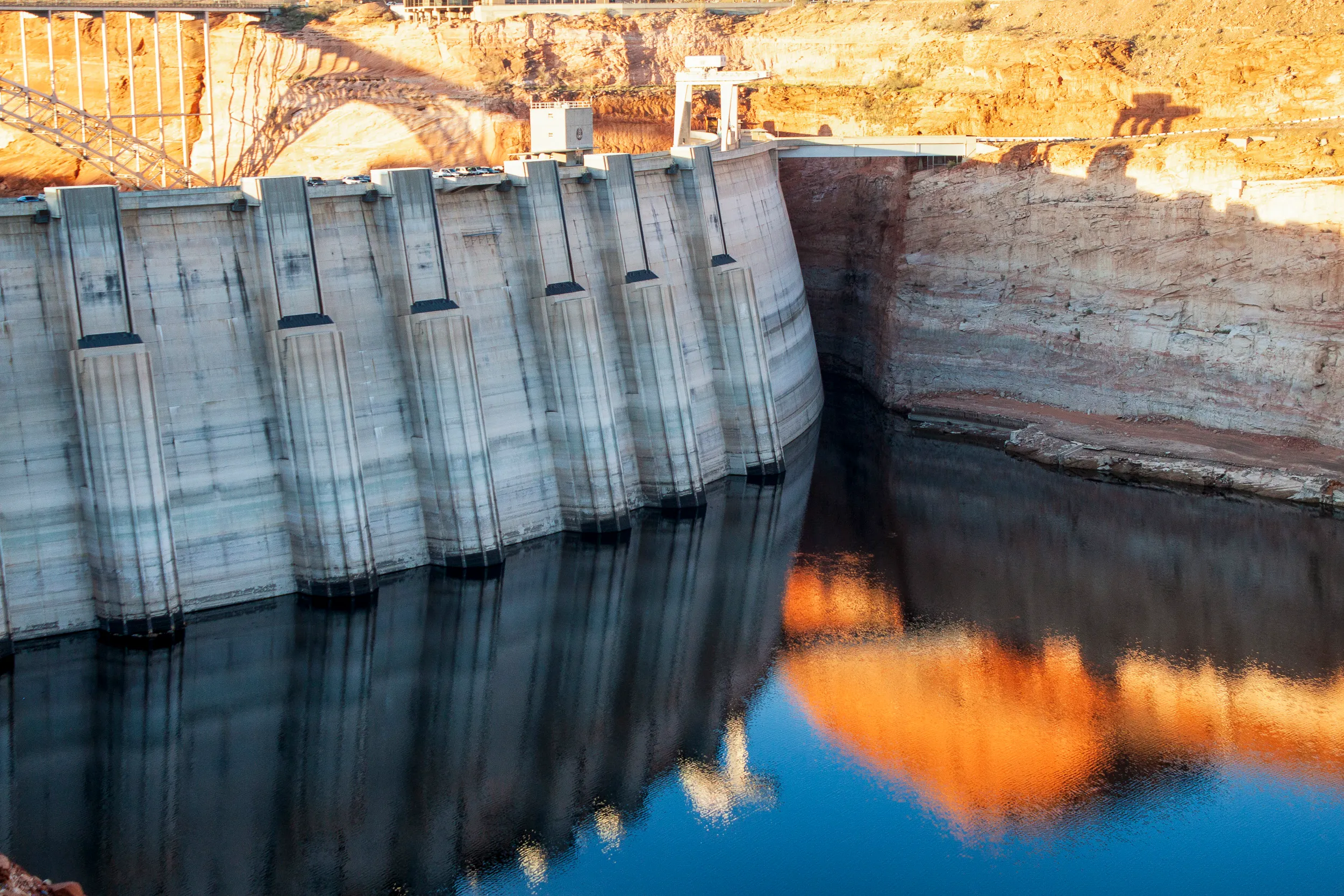
Lake Powell is formed by Glen Canyon Dam, a striking 710-ft tall concrete arch braced against ruddy sandstone walls. It plugs the Colorado just after the river enters Arizona. Meant to ensure water deliveries to the lower basin states of Arizona, California, and Nevada, Glen Canyon Dam was finished in 1963 to complement the Colorado River’s audacious engineering that distributes water through mountains and uphill to the largest cities in the Southwest and to the region’s most productive farmland. When full, Lake Powell holds enough water to flood the entire state of Virginia to the depth of one foot.
Climate change and water demand that still exceeds supply have flipped the engineering script. Lake Powell is less than 25 percent full today. Glen Canyon Dam, instead of being a guarantor of water, is now the most significant water chokepoint in the basin. The hard-won asset has become a glaring liability.
The back of Glen Canyon Dam circa 1964, not long after the reservoir had begun filling up. Here the water level is above dead pool, meaning water can be released via the river outlets, but it is below minimum power pool, so water cannot yet enter the penstocks to generate electricity. Bureau of Reclamation photo. Annotations: Jonathan P. Thompson
The reversal of fortune is because of how Glen Canyon Dam was designed. The dam was never meant to be operated at the extremely low water levels that Lake Powell is rapidly approaching. Doing so for extended periods of time could damage the pipes that move water through the dam, according to the Bureau of Reclamation, the federal agency that manages the structure.
Reclamation is now studying its options for retrofitting Glen Canyon Dam to accommodate a lower Lake Powell. It expects to release those findings later this year or in early 2027. As any home remodeler knows, renovating an aging structure is neither quick nor cheap, especially when failure could have disastrous consequences.
In the short term, Reclamation is relying on operational band-aids for Glen Canyon Dam and Lake Powell. With the consent of the seven states in the basin – Arizona, California, Colorado, Nevada, New Mexico, Utah, and Wyoming – the agency took unprecedented action this month to prop up the reservoir. Releasing more water from upstream reservoirs and holding back more in Powell will delay Glen Canyon’s infrastructure reckoning. But that day will soon come, and Reclamation’s answer to the dam’s engineering problems will have far-reaching implications – not only for the reliability of the basin’s water supply, but also for its power customers, ecology, and recreation economy.
An Assessment Deferred
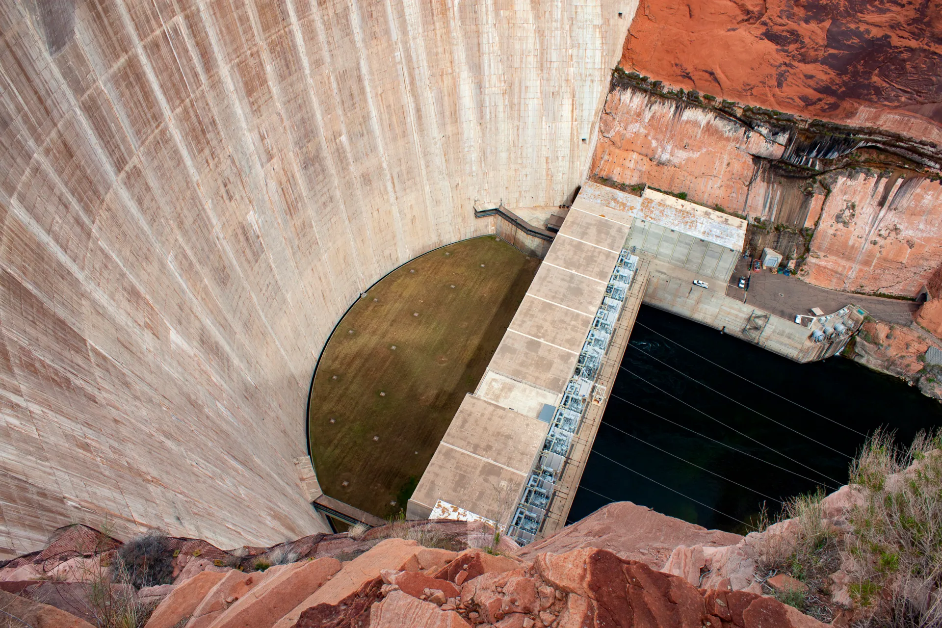
Dams are difficult to manage under any circumstance. Management is even more troublesome when operators must balance multiple, conflicting objectives. In Glen Canyon’s case those objectives are water supply, flood control, hydropower generation, and releasing water to protect the ecology downstream in the Grand Canyon – namely, beach-building and threatened native fish like the humpback chub. This is in addition to ensuring the safe operation of the dam itself.
How to operate Glen Canyon Dam and Hoover Dam, its larger downstream sibling, is what the seven basin states and Reclamation are attempting to figure out right now. The current agreement covers operations through 2026. Reclamation published a draft environmental impact statement, or EIS, in January that would impose severe cuts on water users in the lower basin, particularly Arizona, in part to protect Glen Canyon Dam’s fragile infrastructure.
For that reason, water users in the lower basin and elsewhere support an engineering fix for Glen Canyon Dam. Many were incredulous that Reclamation did not include an assessment of dam modifications in its draft environmental analysis.
“This EIS could have been a great avenue to look at real changes at Glen Canyon Dam that could solve the water delivery problem and some of the ecological problems, too,” Balken said.
Patrick Dent is the assistant general manager for water policy at the Central Arizona Project (CAP), which delivers Colorado River water to the densely populated center of the state. He said that CAP does not favor any particular fix – only one that provides dam managers with more flexibility.
“Our primary interest is that they could release water at a lower lake level,” Dent said.
The Gila River Indian Community, which receives Colorado River water through CAP, told Reclamation that the agency has a duty to safeguard the tribe’s water rights, which are at risk if the dam cannot release enough water. “The United States must take action to fix Glen Canyon Dam,” Gov. Stephen Roe Lewis wrote in a March 2026 letter.
The Colorado Water Conservation Board, which represents that state’s water interests, said it supports a reevaluation of Glen Canyon Dam, but “in a separate action” from the EIS.
Becki Bryant, a Reclamation spokesperson, said the agency will release an appraisal study assessing three dam modification alternatives at the end of this year or in early 2027. Any action beyond the study, she said, requires congressional authorization and funding.
Illustration from the report, “Antique Plumbing & Leadership Postponed” from the Utah Rivers Council, Glen Canyon Institute and the Great Basin Water Network. Courtesy of Utah Rivers Council
‘Antiquated Plumbing’
The tool for managing the dam’s multiple objectives, which are a legislative requirement as well as a practical necessity, is the water held in Lake Powell, said David Wegner, a scientist who has worked on Glen Canyon policy for more than four decades. But even water has limits when the engineering is inadequate. “Sadly, these dams were not built for multiple objectives,” Wegner said. And Glen Canyon was certainly not built for extremely low water, he added.
The problem with Glen Canyon is what a coalition of environmental groups calls the dam’s “antiquated plumbing.” The groups – Glen Canyon Institute, Great Basin Water Network, and Utah Rivers Council – published a report in August 2022 that outlined these engineering deficiencies.
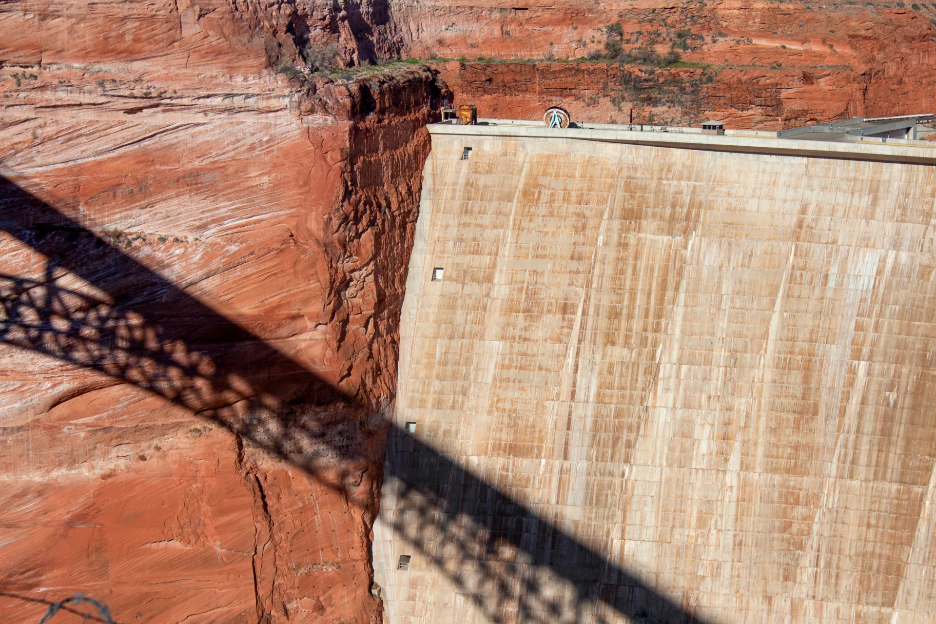
Water can exit Glen Canyon in only three ways. One is the spillways, a pressure-release valve for flooding, which are located at elevation 3,648 feet, near the top of the dam. They are irrelevant today. Lake Powell rests 122 feet below them.
The main exit point is through the eight penstocks, the 15-foot diameter tubes that move water through the turbines to generate hydroelectricity. The penstocks are incapacitated when Powell drops below 3,490 feet. (The lake today is 36 feet higher than that level.) If the lake falls below what is known as minimum power pool, hydropower generation also ceases.
If that happens, water must be released through four 8-foot diameter pipes called the river outlet works. Smaller than the penstocks, the river outlet works are located at elevation 3,370. Below that elevation water cannot be released from Powell, a status known ominously as “dead pool.” (Functionally, the river outlet works may be useless at elevation 3,394, Reclamation says.)
The environmental groups identified two limitations with the river outlet works. One is that they were not designed to be operated full-time. They are a role player, not the star. The other is that their smaller size means less water can pass through them. That’s a problem because the upper basin states of Colorado, New Mexico, Utah, and Wyoming are required to send a set amount of water downstream to the lower basin, according to the 1922 Colorado River Compact that divided the river.
The flow restrictions imposed by the river outlet works, if they had to be used full time, means that the upper basin could violate the compact, which could mean water cutbacks imposed by the lower basin.
“It’s just so counterintuitive that the tool that was designed to meet this delivery obligation” – the construction of Glen Canyon Dam – “is now going to be the roadblock that may prevent the delivery obligation from being met,” said Balken of the Glen Canyon Institute.
The engineering problems are not a new discovery. Wegner, who was with the Bureau of Reclamation at the time as its Grand Canyon environmental studies manager, helped lead a 1987 National Academies report on Glen Canyon. The report recommended that the Interior Department consider the “installation and operation of multiple outlet structures” at Glen Canyon, which would give dam managers more flexibility with water releases.
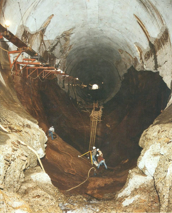
Glen Canyon’s structural problems were substantiated in 2023, when Reclamation used the river outlet works during an experimental “high-flow” release of water to flush sediment downstream and rebuild eroding Grand Canyon beaches.
The high-volume release caused pitting, or cavitation, within the river outlet works, a risk that was heightened due to the physics of water when Lake Powell is low. Reclamation coated the pipes with epoxy as a temporary fix to prevent more damage, a process that took several months. The agency has since used two small-scale physical models at its Technical Service Center in Denver to test dam operations at low water levels and the effect on infrastructure.
Reclamation acknowledged the limitations of the river outlet works in a technical memopublished in March 2024 by Richard Lafond, director of the agency’s Technical Service Center. The memo’s conclusions were endorsed by the top decision-makers in Reclamation’s Upper Colorado River Office.
“Long term operation of the river outlet works will result in accelerating regular operation and maintenance tasks,” LaFond wrote. Reclamation should “not rely on the river outlet works as the sole means for releasing water from Glen Canyon Dam.”
Wegner put it in starker terms. If the river outlet works had to be relied upon and the pipes began to erode again, then Reclamation could potentially lose control of water flows.
“Potentially that could fail,” Wegner said, meaning an inability to control water releases through the dam if the pipes are structurally compromised. “And if that fails, now you have a catastrophe on your hand and you have limited options to manage that catastrophe.”
In other words, there would be no way to release water downstream into the Grand Canyon and into the lower basin.
Neither Quick Nor Easy
What fixes are possible? Reclamation received $2 million from Congress in the fiscal year 2022 budget for an appraisal study.
Reclamation outlined three engineering possibilities in a 2023 presentation, most of which centered on preserving hydropower generation as Lake Powell declines.
One possibility is a new, lower intake that uses the existing power generation turbines. An intake located deeper in the reservoir would allow Glen Canyon to pass water in what is currently dead pool. But it would entail “increased risk from penetration through the dam.”
The second would connect new power generation equipment to the river outlet works.
The third option is tunneling through the canyon wall and installing a new underground power station. This would also provide more flexibility for water releases.
Reclamation also included three operational or policy changes for power production, including investing in wind and solar to offset hydropower declines.
Other ideas that seemed kooky and fringe just a few years ago – draining Lake Powell and filling Lake Mead first; changing the basin’s water accounting system – are now being discussed throughout the basin with more seriousness and candor.
Beyond that presentation, Reclamation has not said much publicly about dam modification. The agency declined an interview request to discuss Glen Canyon Dam’s engineering problems.
Whatever direction Reclamation chooses – an option outlined above or something new – the process will not be quick or easy. Any change to Glen Canyon must go through an environmental analysis and public comment period. Congress will have to authorize actions and appropriate the funds. Construction alone will take years.
Wegner, who was the staff director for the House Natural Resources Water and Power Subcommittee from 2008 to 2014, knows the difficulty and sees a lack of leadership. “There’s nobody in Washington who has been willing to lead the charge trying to get Congress to provide authorized funding to do this sort of work.”
‘Reservoir Triage’
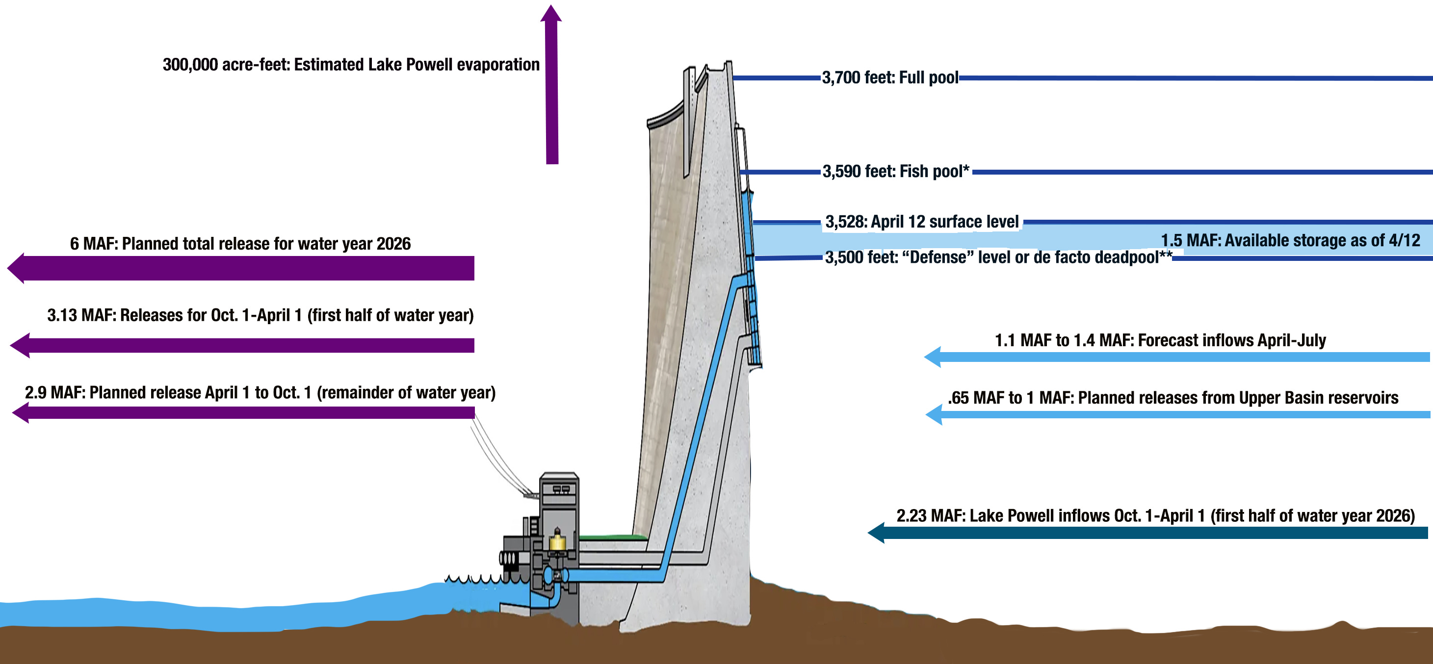
Because Reclamation is not confident it can operate the river outlet works for an extended run, the agency is focused on keeping Powell above elevation 3,500 feet.
Protecting 3,500 feet comes with all sorts of baggage. It preserves hydropower generation, which power customers appreciate. But in effect the redline at that elevation strands some 4.4 million acre-feet in Lake Powell. (Only 3.7 million acre-feet is technically accessible with the current plumbing.) Some have called this elevation a “de facto” dead pool. Thus, the agitation in the lower basin for a plumbing system within the dam that provides access to this water.
Balken said that downstream water deliveries, not preserving hydropower, should be Reclamation’s biggest concern.
“When these decision makers are talking about Glen Canyon Dam from only a hydropower perspective, I think it’s missing the larger point, which is the dam is about to become the biggest roadblock of water deliveries that the basin has ever seen,” Balken said.
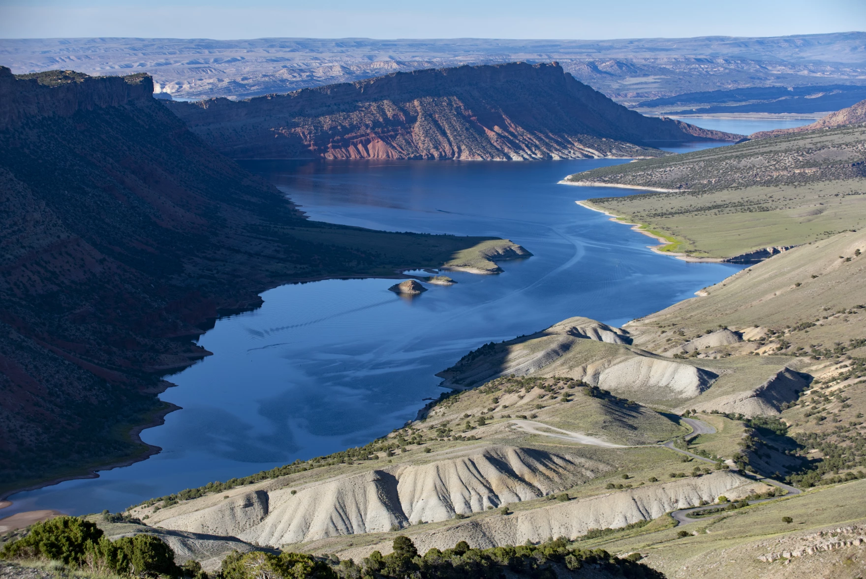
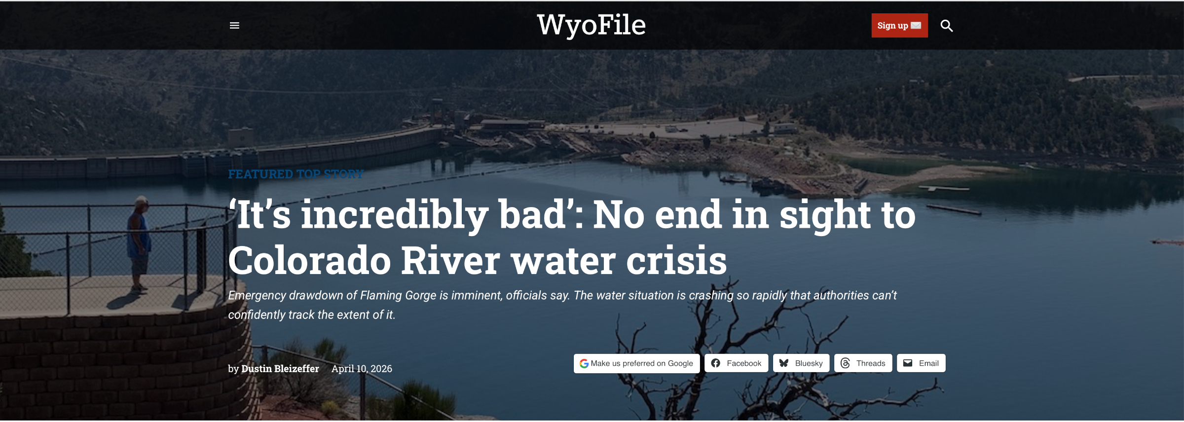
Flaming Gorge Reservoir, on the Green River, straddles the Wyoming-Utah border south of Rock Springs. The Flaming Gorge dam, on the Utah side, was completed in 1964 and is a critical component of the Colorado River water storage system. The Green River, the chief tributary to the Colorado River, originates in the Wind River Range, flows to Flaming Gorge Reservoir, then connects with the Colorado River in Canyonlands National Park in Utah.
To avoid the infrastructure risks of dropping below 3,500 feet, Reclamation has started to take extraordinary action. The agency has two emergency levers it is pulling. One is to hold more water back in Lake Powell. Reclamation cut water releases to the legal minimum this year, something it has never done. The other is releasing more water from Flaming Gorge, a reservoir upstream that is in better shape.
As Balken describes it, “This is reservoir triage.”
These emergency actions have serious side-effects. Upstream, Flaming Gorge is expected to lose 35 feet of elevation by next spring, once the extra water has been released. That will hurt the recreation economy of northeastern Utah and southwestern Wyoming – fewer boat ramps in the water, less fishing access.
These upstream releases have limited utility, Wegner said. “You can do that once or twice. But you got to then depend upon Mother Nature refilling those reservoirs upstream.”
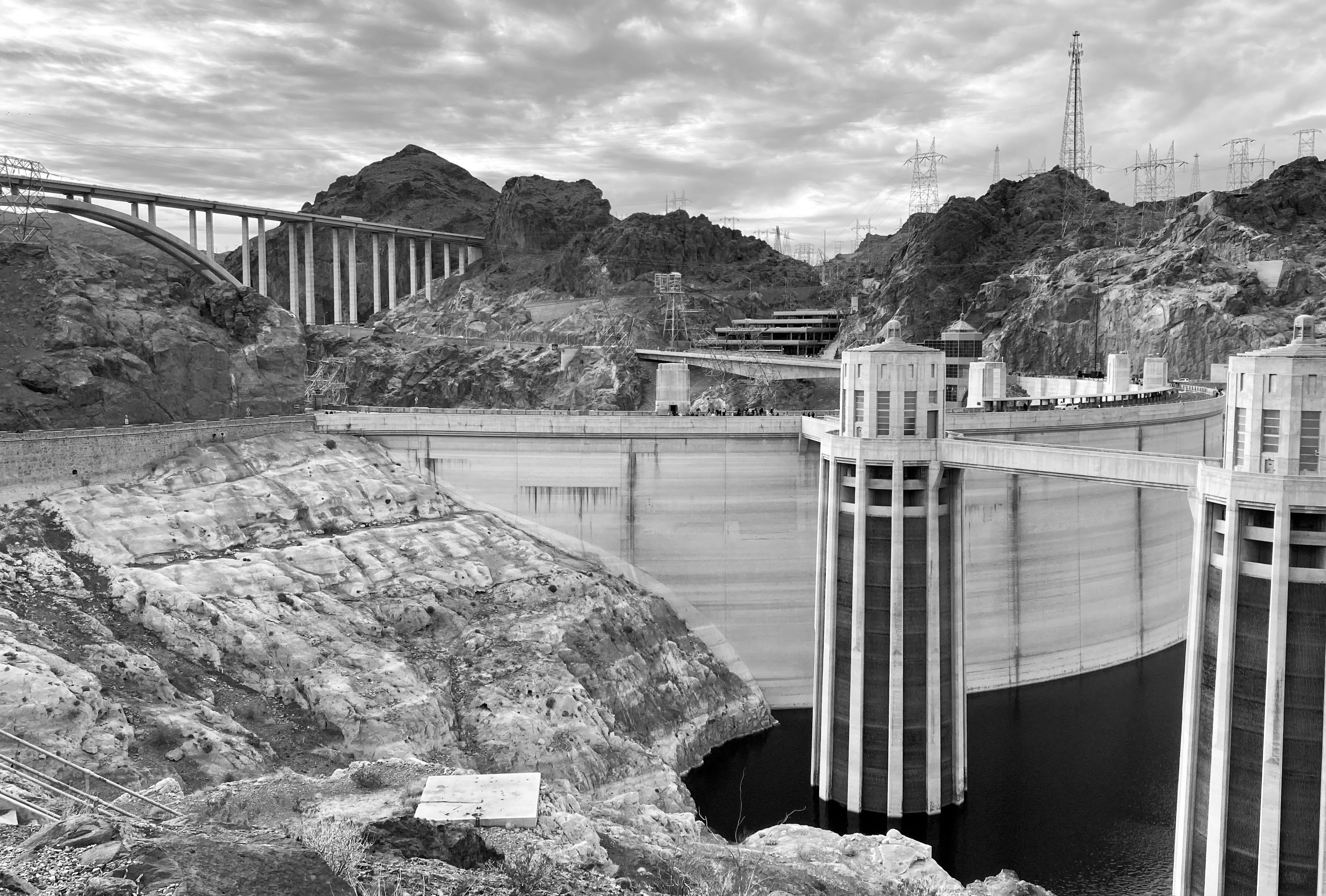
Hoover Dam at low water. Jonathan P. Thompson photo.
Downstream, Lake Mead will drop quickly and it too will approach a level in which hydropower generation at Hoover Dam severely drops. Algal blooms in a warmer, shallower lake could be a problem. “They’re going to be robbing Mead to pay Powell,” Balken said.
Trying Not to Hit Bottom
The idea of dead pool – when Lake Powell can no longer release water – was almost inconceivable when the reservoir was designed and filled. The official device for measuring Lake Powell’s elevation ends at the top of the penstocks, at elevation 3,477.5 feet. According to Reclamation’s 2024 technical memo, “This is an indication that reservoir elevations below minimum power pool” – 3,490 feet – “were not anticipated.”
Cavitation at the Glen Canyon Dam, the cause of the emergency in 1983 via Flow Science.
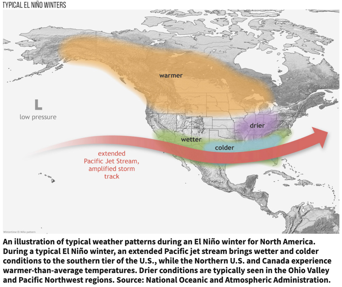
Reclamation finished filling the reservoir in 1980. Three years later, after an intense El Niño winter, the dam’s upper limits were tested. Floodwaters in the summer of 1983 nearly broke the dam. Such volumes are almost inconceivable now.
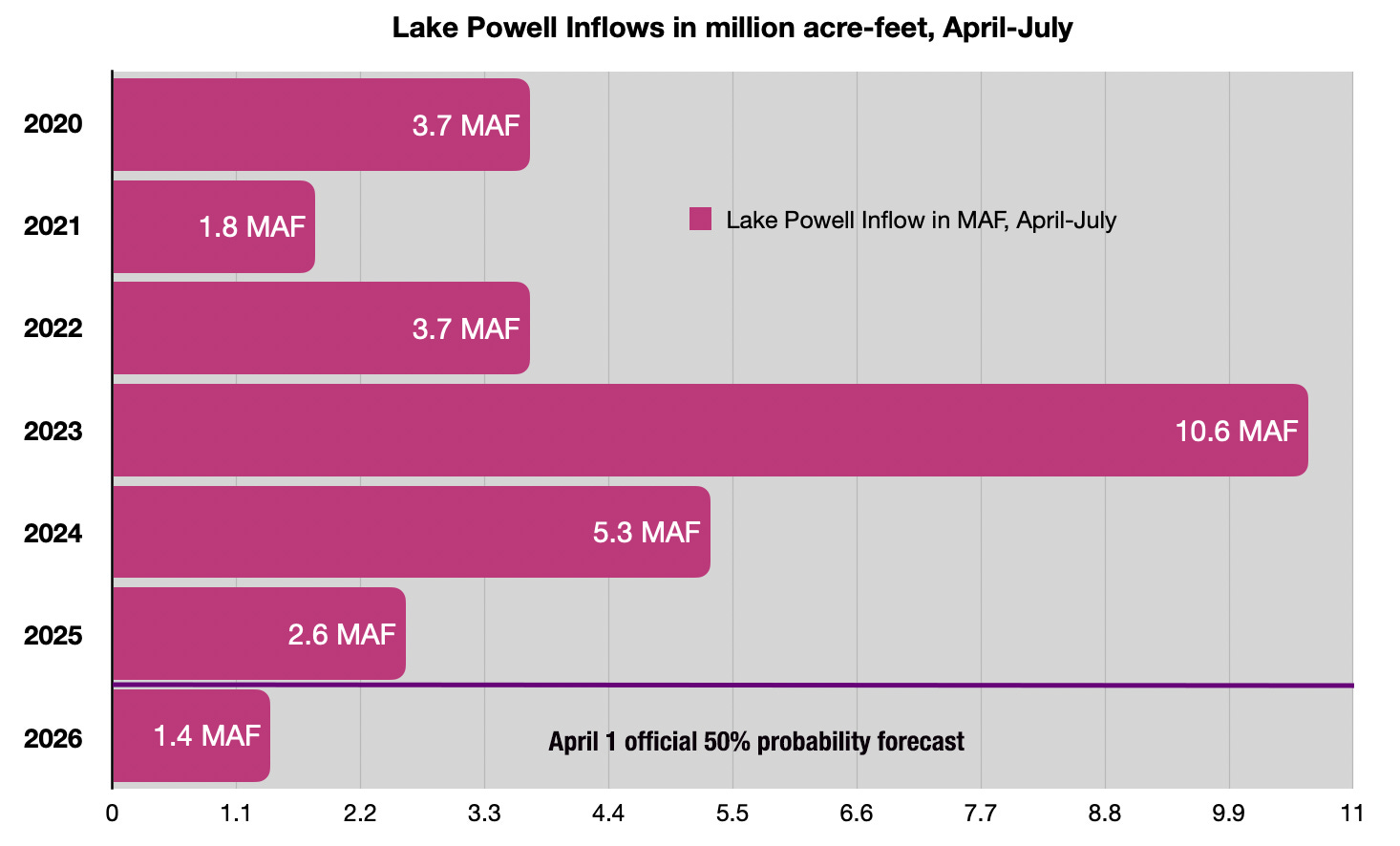
In a typical year, Lake Powell would be rising in late April, flush with the deposits of snowmelt from headwater basins in the Rocky Mountains. Not this year. The snowpack peaked in many basins in late February or early March. What little snow there was has already melted. As of April 28, Lake Powell inflows are projected to be just 16 percent of average. Lake level forecasts from mid-April showed a long downward slope for the next 12 months. Those projections were what triggered the emergency release of water from Flaming Gorge and the reduction in Lake Powell releases.
Scientists have been warning about circumstances like this for years. In a defining period for the basin, all the predictions of water supply shocks in the Colorado River from the past two decades are coming to pass.
“We should have been prepared for this,” Balken said.
Click the link to read the article on the Big Pivots website (Allen Best):
April 26, 2026
The staff at the Colorado River District showed this slide during a session on Colorado River hydrology at the district’s board of director meeting in Glenwood Springs this past Tuesday afternoon.
Here in metro Denver, the staff of Big Pivots said something profound like “holy moly!”
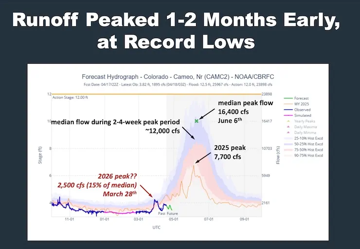
With moisture coming into Colorado during the next two weeks, it’s possible that the runoff into Lake Powell may surpass that of 2002. This slide says that right now, at Cameo, the gaging station on the Colorado River, east of Palisade, it looks like the spring runoff peaked in late March. The usual is in early June.
Another takeaway from the River District meeting was about Green Mountain Reservoir. The dam that creates the reservoir was built from 1938 to 1943, giving the Western Slope a way to store water as part of the Colorado-Big Thompson diversion that came after World War II. The normal allotment of the reservoir storage for downstream irrigators, mostly in the Grand Junction area, is 66,000 acre-feet.
For the first time in the history of Green Mountain, said Andy Mueller, the River District’s general manager, the water is unavailable. Instead, the river district is tapping various pools of water over which it has control to come up with a thimbleful here, a cup there. A creative solution, Mueller called it. Irrigators won’t become whole, but they will get some help.
“We’ll survive, and we will continue to survive,” said Mike Ritschard, a director from the Kremmling area and a fourth-generation rancher there, said during a roundup of reports from board members.
Created in 1937, one of the ramifications of the Colorado-Big Thompson water diversion, the River District has primary responsibility for water matters across 15 of the 20 Western Slope counties.
The Colorado River Water Conservation District spans 15 Western Slope counties. Colorado River District/Courtesy image
When Donald Trump was elected president for the second time, we all knew what was coming to the nation’s public lands: The administration would favor extractive uses by eviscerating environmental protections, rolling back regulations, and leasing out as much land as possible while handing out drilling permits like Shriners throwing candy at a parade.
Yet there was one realm where I figured the administration couldn’t bestow any more deregulatory gifts, namely public lands grazing. It’s not that I thought Trump would clamp down on the destructive practice, it’s just that I figured the status quo was about as permissive as it could get. Past administrations, be they Democratic or Republican, have generally shied away from updating or reforming public lands grazing policies out of fear of inflaming the West’s cowboy culture — even if it is based largely on myth.
But Trump, his Interior Secretary Doug Burgum, and Agriculture Secretary Brooke Rollins are intrepidly going where previous administrations did not dare: grazing reform. Well, sort of, though maybe not in the way public lands lovers might have hoped. In fact, they are doing their best to make grazing policy even more lax with a goal of getting more cattle out there to trample public lands, cryptobiotic soils, and cultural sites.
Last month, Burgum and Rollins announced an MOU between the two agencies designed to “boost the supply of American born, raised, and harvested beef” by cutting “bureaucratic red tape” and giving the livestock industry more control. The MOU has a goal of “maintaining grazing capacity wherever possible, including no net loss of Animal Unit Months within allotments,” even if those allotments are degraded or in poor health. In Burgum’s words, one goal is to “preserve America’s ranching heritage for generations to come.” Forgive me for getting anxious whenever I see “heritage” used in conjunction with public lands.
“Today’s signing sends a clear message: the Trump administration is putting America’s farmers and ranchers first,” said Secretary of Agriculture Brooke Rollins. Which brings up the question of what message the administration was sending in February when Trump signed an executive order to quadruple beef imports from Argentina in an effort to keep Big Macs affordable.
🗺️ Messing with Maps 🧭
To help it carry out its mission, the Bureau of Land Management has released an interactive map aimed at putting more cattle and sheep back on public lands. The “federal grazing lands potentially available” map shows allotments that have been vacated, often as a result of deals brokered by environmentalists, with the intent of peddling the tracts to livestock operators. While there’s no guarantee that the BLM would lease out all of the vacant tracts, the presence on the map of the ones vacated for environmental purposes is enough to set off alarm bells.
Grazing allotments listed as “potentially available” for leasing on the BLM’s new map. The five parcels closest to Silverton were retired in 2023 to protect bighorn sheep. Source: BLM
For example, the map includes 10 allotments in the high country around Silverton, Colorado, totaling about 70,000 acres. In 2023, the National Wildlife Federation paid the Etchart Sheep Ranch to vacate five of these allotments in an effort to give Rocky Mountain bighorn sheep more breathing room and protect them from diseases transmitted by domestic sheep. The deal was made with the hope that the leases would be retired permanently. Yet the inclusion on the map indicates they could see domestic sheep once again, emphasizing the need for legislation that would make such retirements perpetual.
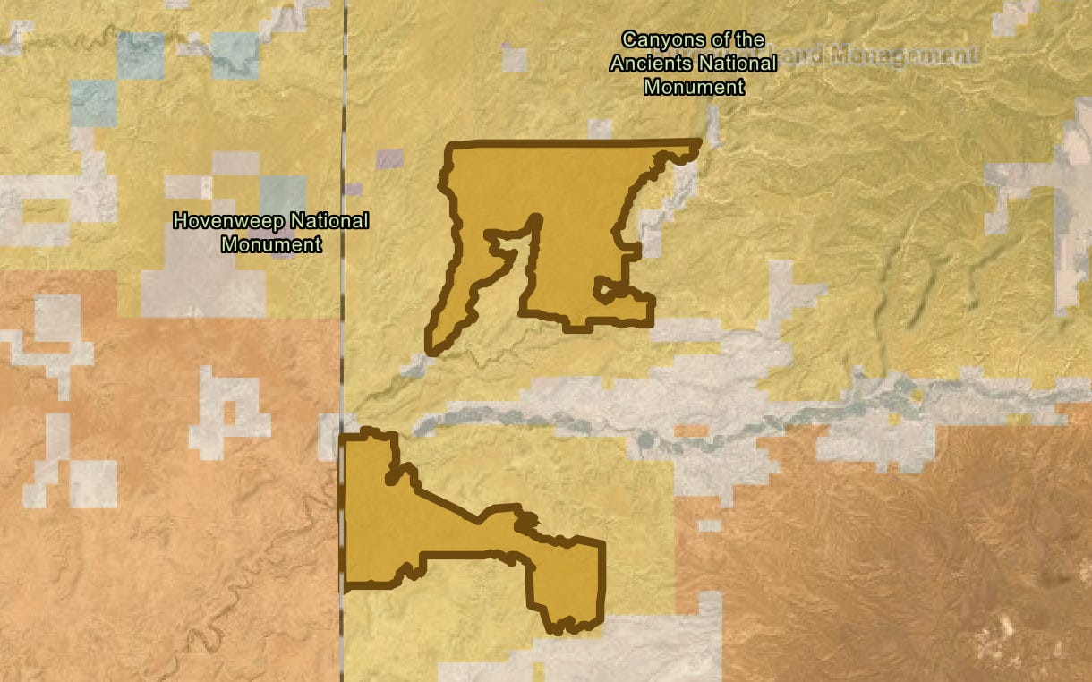
Also on the map are the Flodine Park and Yellowjacket allotments in Canyon of the Ancients National Monument near the Colorado-Utah border. In 2005, a rancher gave up the allotments, north and south of McElmo Canyon, respectively, and sold 4,500 acres of adjacent private land to the BLM to add to the national monument. Both allotments and the private land contain a number of intermittent streams, shallow canyons, and numerous cultural sites. They had been grazed relentlessly for decades prior, and showed the wear and tear—much of the cryptobiotic soil had long before been trampled and destroyed and invasive cheat grass had infiltrated the grazed areas. An archaeological assessment conducted later found grazing had damaged dozens of sensitive and cultural sites in the areas.
The Yellowjacket and Flodine Park allotments in Canyons of the Ancients National Monument. They have been vacant since 2005, and a previous effort to lease them out again was halted. Now it looks like they may be back on the block. Source: BLM
In 2010, the BLM, which manages the monument, issued a new resource management plan, which allowed for continued grazing, but also opened the door to permanently retiring vacant grazing allotments if they fail to meet BLM rangeland health standards or when grazing is negatively impacting cultural sites. Five of the 28 allotments in the most heavily visited areas—including Sand Canyon—were cancelled, but not the Flodine Park and Yellow Jacket allotments, which were still in retirement at the time.
Instead, the local county commissioners and a group of ranchers pressured the BLM to reauthorize grazing on both allotments—to bring them out of retirement, if you will. The BLM acquiesced, but environmentalists and tribes with roots in the area fought back, forcing the agency to do a more thorough environmental analysis of the proposal. The opposition was enough to prompt the agency at least to delay issuing any leases, and the allotments remain in limbo.
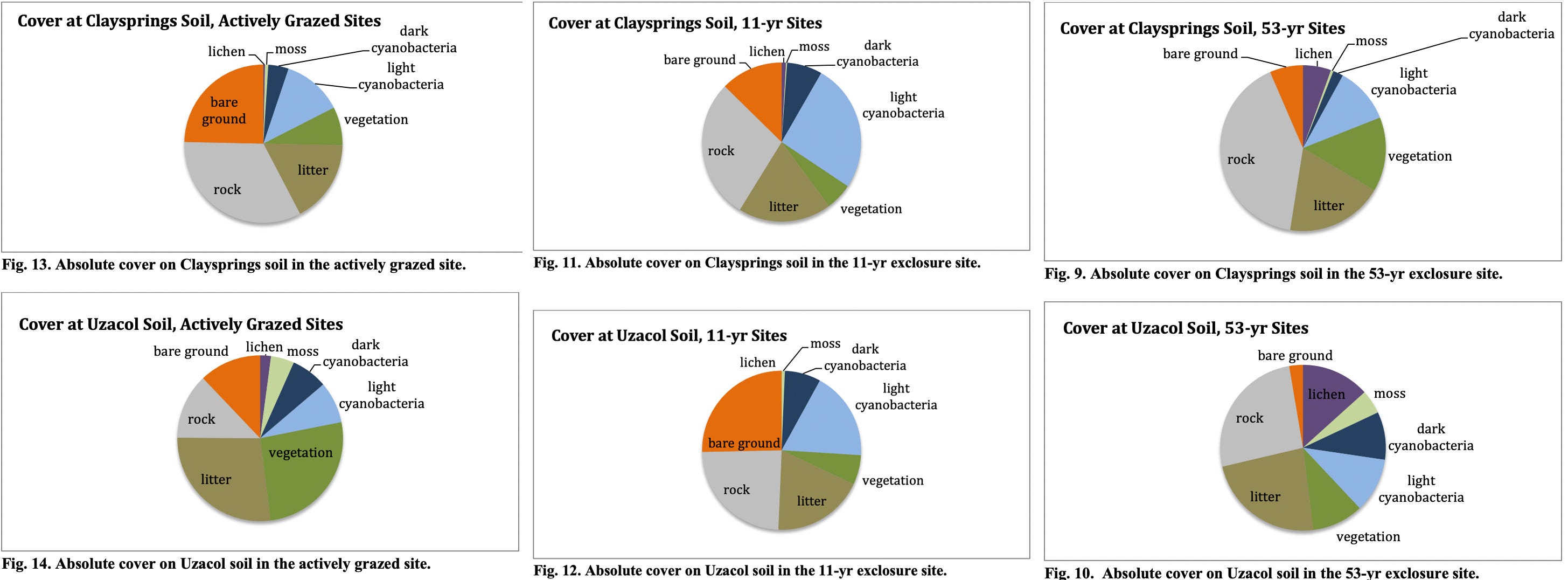
Meanwhile, a team of scientists assessed the healing process on the Flodine Park and Yellow Jacket allotments, which by then had been cow-free for 11 years (though feral horses had grazed there). They compared biocrusts on those allotments to a fenced enclosure that hadn’t seen grazing for 53 years and a plot that was being actively grazed. What they found was both predictable and remarkable: The longer a plot went without cows, the healthier it was, as summed up by these graphs.
Source: Grazing, Rest, and Biological Soil Crust in Canyons of the Ancients National Monument Marc Coles-Ritchie, Lior Gross and Mary O’Brien, Grand Canyon Trust.
While the natural landscape can eventually heal itself, livestock’s damage to the cultural landscape is irreversible. BLM surveys identified 266 cultural sites on the two allotments, including 35 with “standing architecture.” At least 43% of those had been damaged by livestock.
Now what’s left may be in danger, too, at least if those allotments’ presence on the new map is any indication. And guess what? Packing these allotments isn’t going to make that steak any cheaper. Only about 1% of American beef is grazed on public lands.
Mt. Blue Sky at 14,130 feet in elevation on April 22, 2026. Jonathan P. Thompson photo.
⛈️ Wacky Weather Watch ⚡️
If you were to get all of your information about the West’s climate from daily weather reports and road condition websites, you might think that April snow showers and deep freezes had ended the snow drought and would lead to big May streamflows. After all, it snowed enough in Colorado to turn roads to slip-and-slides and causing a 75-car pileup on I-70 near the Eisenhower Tunnel. The temperatures dropped low enough to wipe out most of the fruit blossoms the March heat wave tricked into blooming early. Only the farmers who used extraordinary measures — starting fires or smudge pots in the orchards, running wind machines, etc. — could save some of their summer harvest.
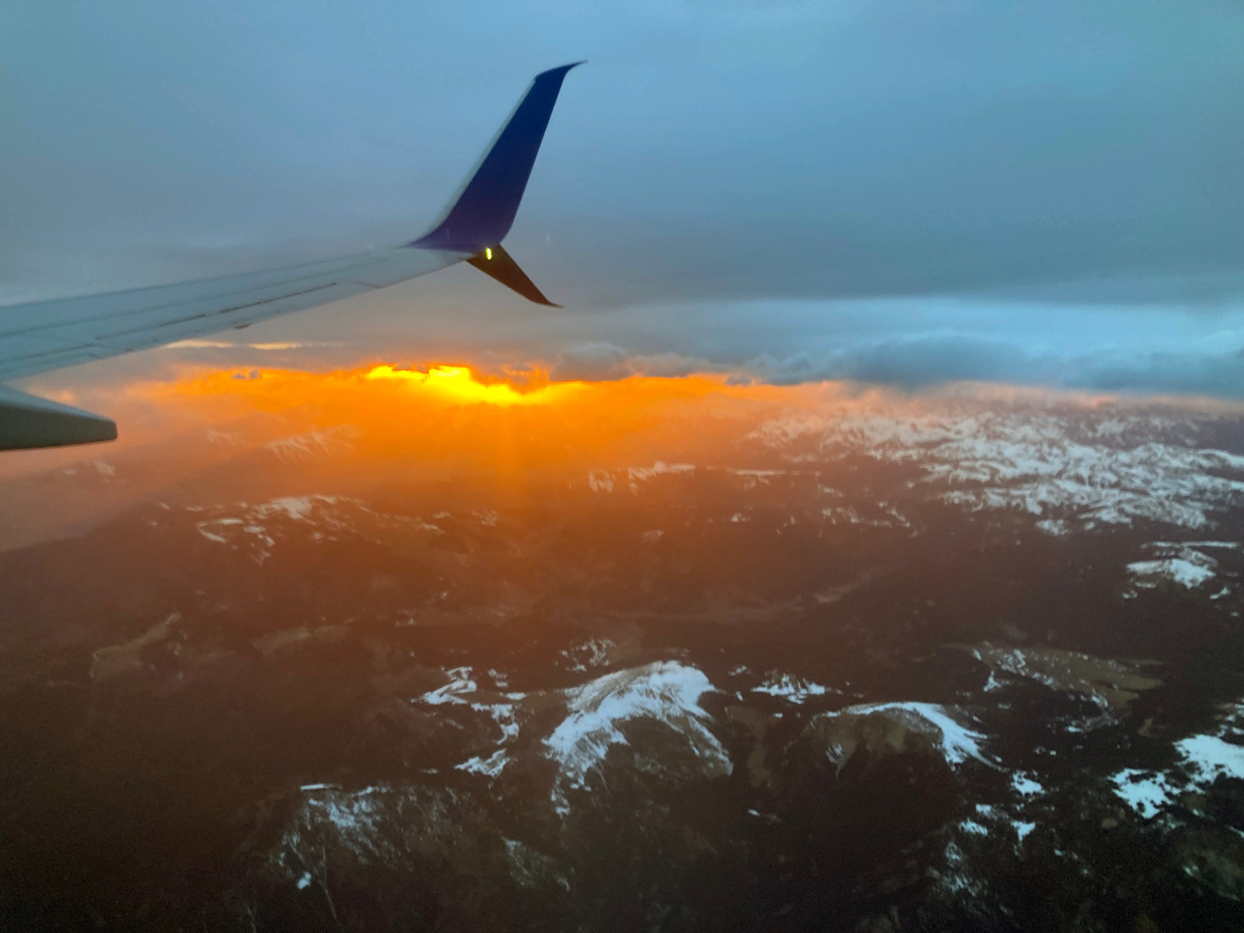
Sunset over the San Juans. Jonathan P. Thompson photo.
Sure, the snow that did fall in April helped, but only enough to elevate snowpack levels to, well, the lowest on record (only by a slightly smaller margin than before). And the freeze was deep, which helped extend the spring runoff in the few areas where there was any snow left. But even there, I suspect that peak runoff has already come and gone (though I’m not calling the Predict the Peak contest yet!).
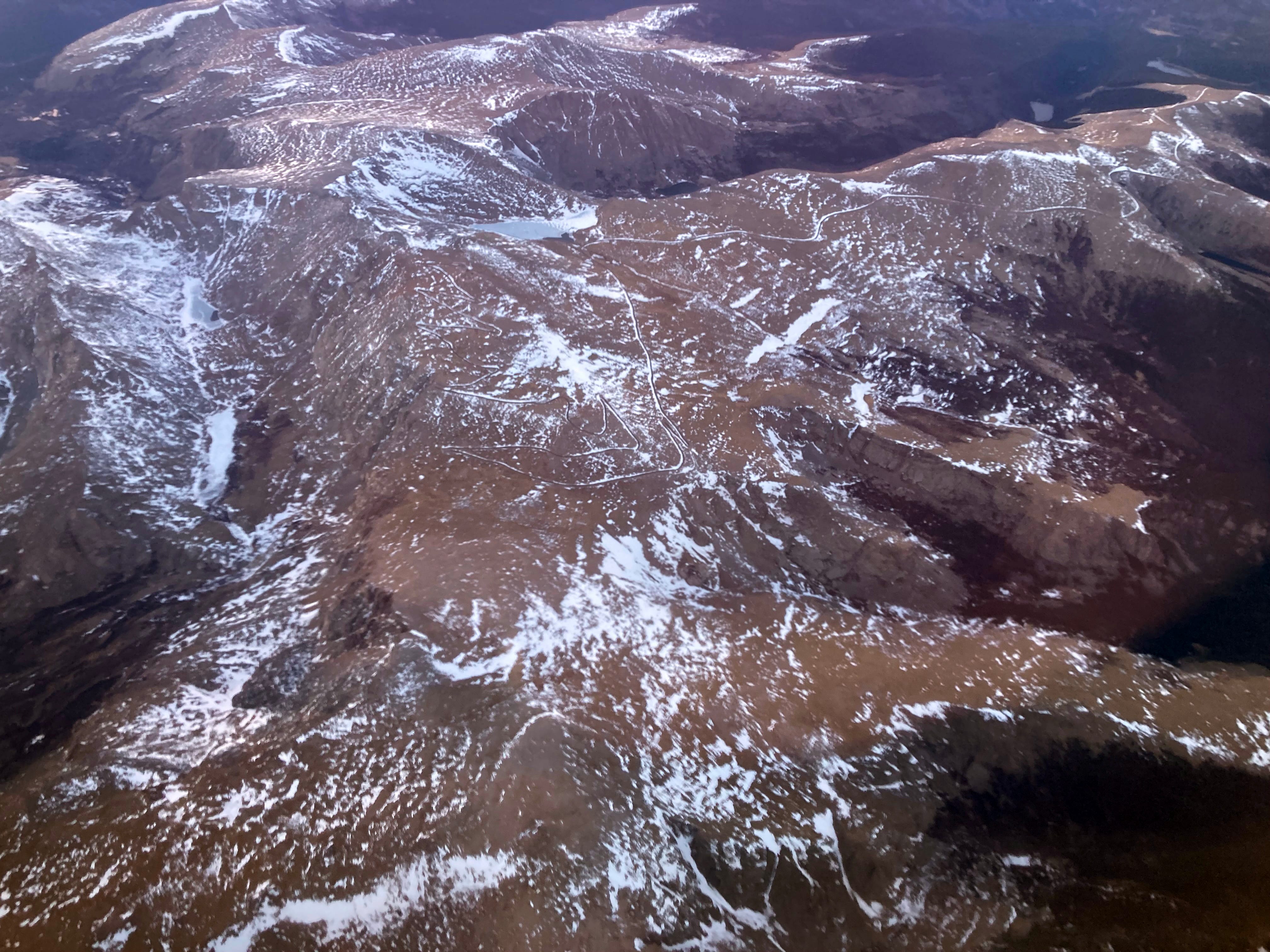
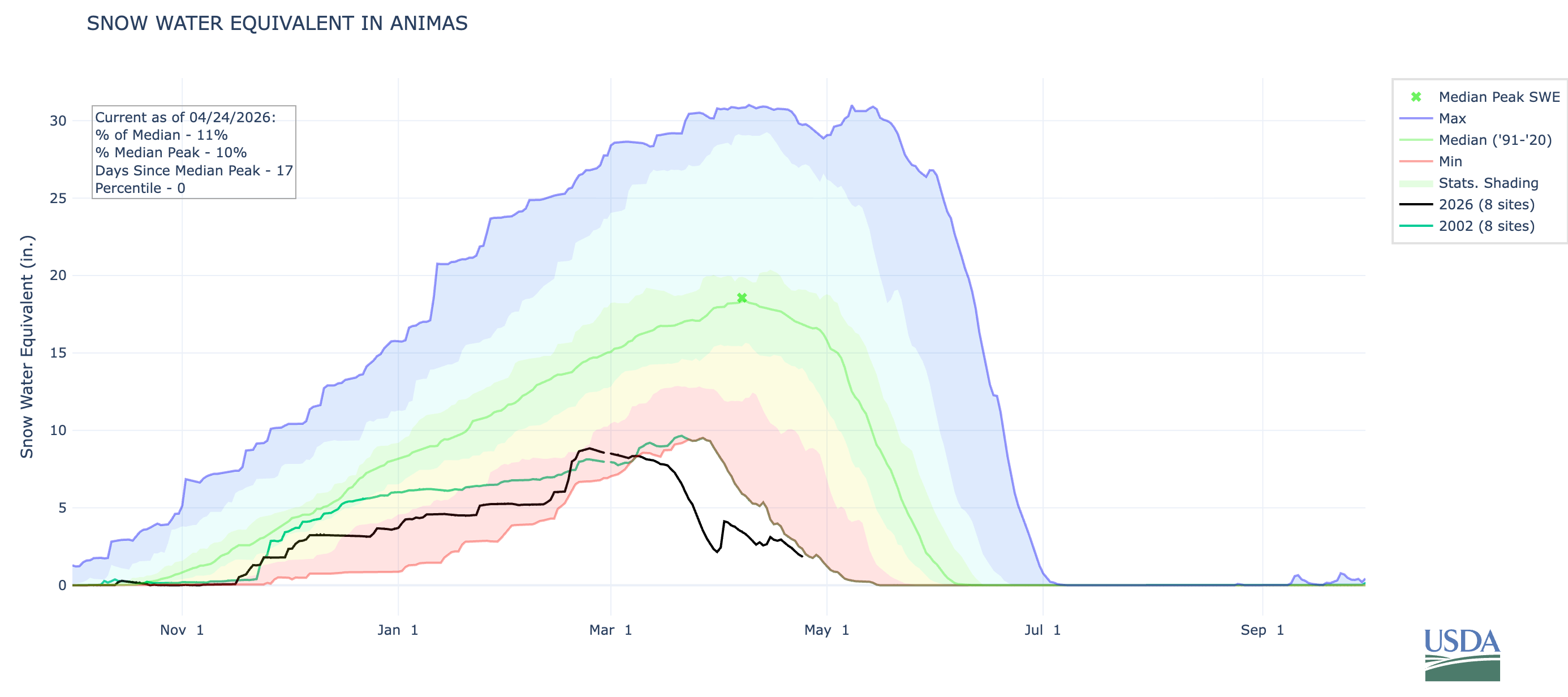
I flew over Colorado’s mountains the other day and was rather shocked at the dearth of snow, even on the highest peaks. Mt. Blue Sky, formerly Mt. Evans, had only a few patches of white left — at 14,130 feet in elevation. Everything below 10,000 feet appeared to be snowless. While the San Juan Mountains appeared to be in slightly better shape, it was still looking pretty dry. The Animas River watershed’s snowpack remains lower than it was on 2002 on this date.
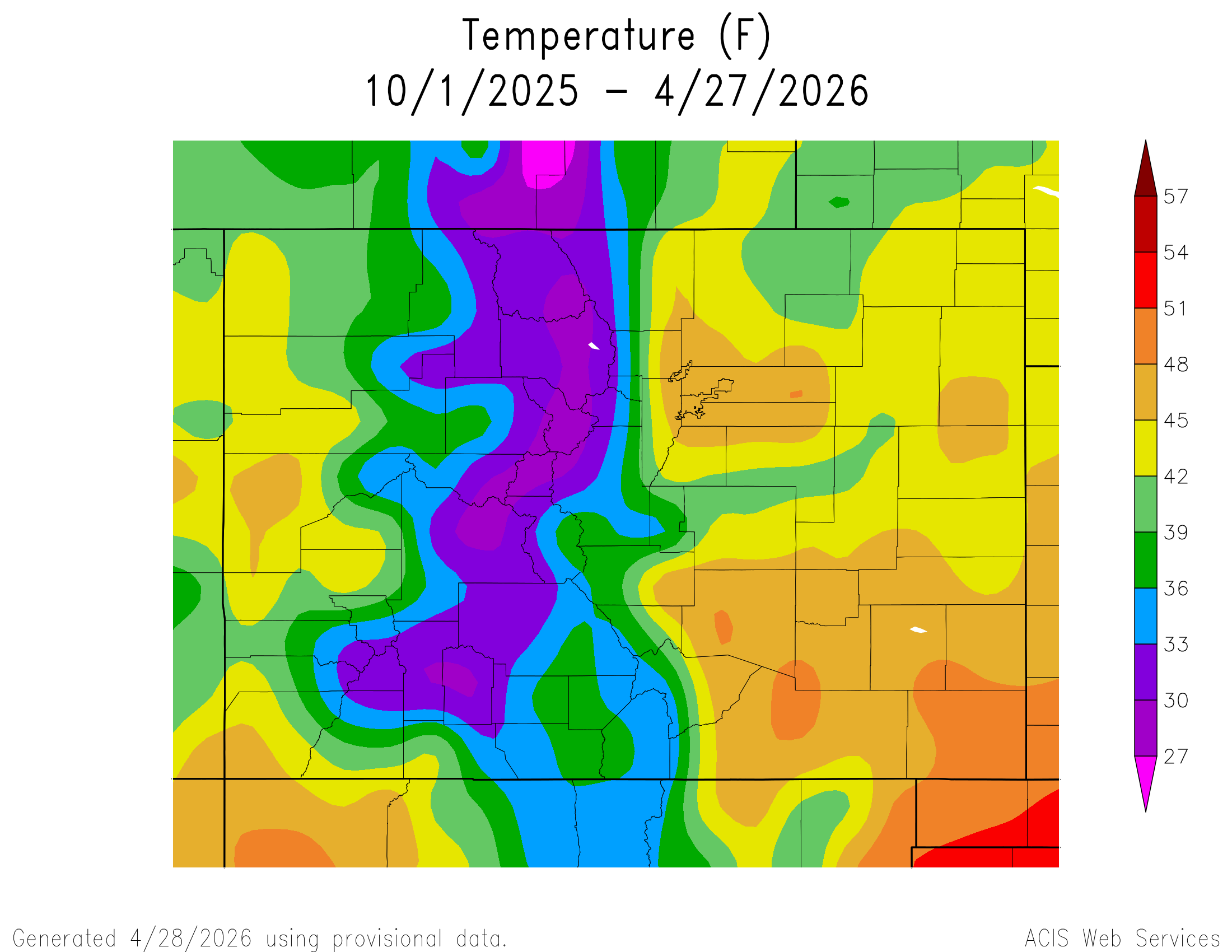
Meteorological records dating back 130 years show a handful of years with winters drier than the 2025-26 winter, said Rebecca Briesmoore, a water resources engineer with the Colorado River District.
“But it has been the warmest by far … that has really been the headline: It wasn’t the driest, but it was the warmest — and that is having a huge impact on hydrology and water resources,” Briesmoore said.
She spoke to a packed room of about 150 attendees at Thursday’s [May 21, 2026] Roaring Fork River: State of the River event hosted by the Colorado River District at the Pitkin County Library…“It’s important for people to know that this year is unprecedented . . . it’s like nothing we have ever seen before,” Briesmoore said. “Every single drop of water really, really matters. We have to think about how we are using it, and what we are going to do with very, very low water resources.”
To a room full of gasps, Briesmoore showed a graph with a star marking the 2026 winter — from October 2025 to March — high above the rest. While years including 1902, 1904, 1977, 2002 and 2018 recorded less precipitation, in terms of temperatures there’s no other year that even came close to 2026.
Map of the Colorado River drainage basin, created using USGS data. By Shannon1 Creative Commons Attribution-Share Alike 4.0
Click the link to read the article on the Tucson.com website (Tony Davis). Here’s an excerpt:
April 26, 2026
It’s time to bring in a mediator to handle the prolonged dispute over managing the Colorado River between the Upper and Lower Colorado River Basin states, representatives of the four Upper Basin states say.
“The proposal for mediation attempts to address the current deadlock between Upper Basin and Lower Basin approaches and begin to deal with the basin’s dire hydrologic conditions.” said the Upper Colorado River Commission, which represents Colorado, New Mexico, Utah and Wyoming.
“The commissioners believe a structured mediation process can support authentic negotiations and collective action to address the Basin’s operational challenges,” the commission said in a news release last week.
The request for a mediator to handle this dispute follows about two years of fruitless negotiations among the various state representatives. There have been several major sources of dispute, but the biggest one has been over how the two basins should split the cuts in river water use that would be needed to bring human demand in line with shrinking supply…The Upper Basin states’ request comes not long before the U.S. Bureau of Reclamation is supposed to announce its plan for managing the river, in the absence of an agreement among the basin states. A new plan is necessary because the river’s current operating guidelines expire Sept. 30…
The request for mediation also comes as the river’s condition continues to deteriorate. Hot, dry weather has held down water flows in the river for most of the year, and there’s a risk that spring-summer runoff into Lake Powell will be the lowest on record since Lake Powell started filling in the 1960s.
Scott Hummer worked for the Colorado Department of Water Resources for many years so he has witnessed many ups and downs for the rivers in northern Colorado. Here are some low flow photos from a recent road trip. First up Stagecoach Reservoir and the Yampa River.
The confluence of the Blue River (L) and Muddy Creek (R) April 22, 2026. Photo credit: Scott Hummer
Streamgage above Stagecoach Reservoir April 22, 2026. Photo credit: Scott HummerStreamgage above Stagecoach Reservoir April 22, 2026. Photo credit: Scott HummerThe inlet to Stagecoach Reservoir April 22, 2026. Photo credit: Scott HummerStagecoach Reservoir April 22, 2026. Photo credit: Scott HummerYampa River inflow to Stagecoach Reservoir April 22, 2026. Photo credit: Scott Hummer
The North Platte River April 22, 2026. Photo credit: Scott Hummer
The North Platte River April 22, 2026. Photo credit: Scott HummerThe North Platte River April 22, 2026. Photo credit: Scott Hummer
Scott Hummer at the inlet to Stagecoach Reservoir July 22, 2021 when I was bumming up and down the Yampa River.
Yampa River Basin via Wikimedia.
Map of the North Platte River drainage basin, a tributary of the Platte River, in the central US. Made using USGS National Map and NASA SRTM data. By Shannon1 – Own work, CC BY-SA 4.0, https://commons.wikimedia.org/w/index.php?curid=79266632
Click the link to read the article on the Summit Daily website (Ali Longwell). Here’s an excerpt:
April 20, 2026
With a historic drought hitting the Colorado River basin, the U.S. Bureau of Reclamation is making preparations to slow releases from the river’s largest reservoir while increasing withdrawals from an Upper Basin reservoir.
“Given the severity of the risks facing the Colorado River system, it is imperative that we take action quickly to protect a resource that supplies water to 40 million people and supports vital agricultural, hydropower production, tribal, wildlife and recreational uses across the region,” said Andrea Travnice, the Bureau of Reclamation’s assistant secretary of water and science in a Friday, April 17 news release…
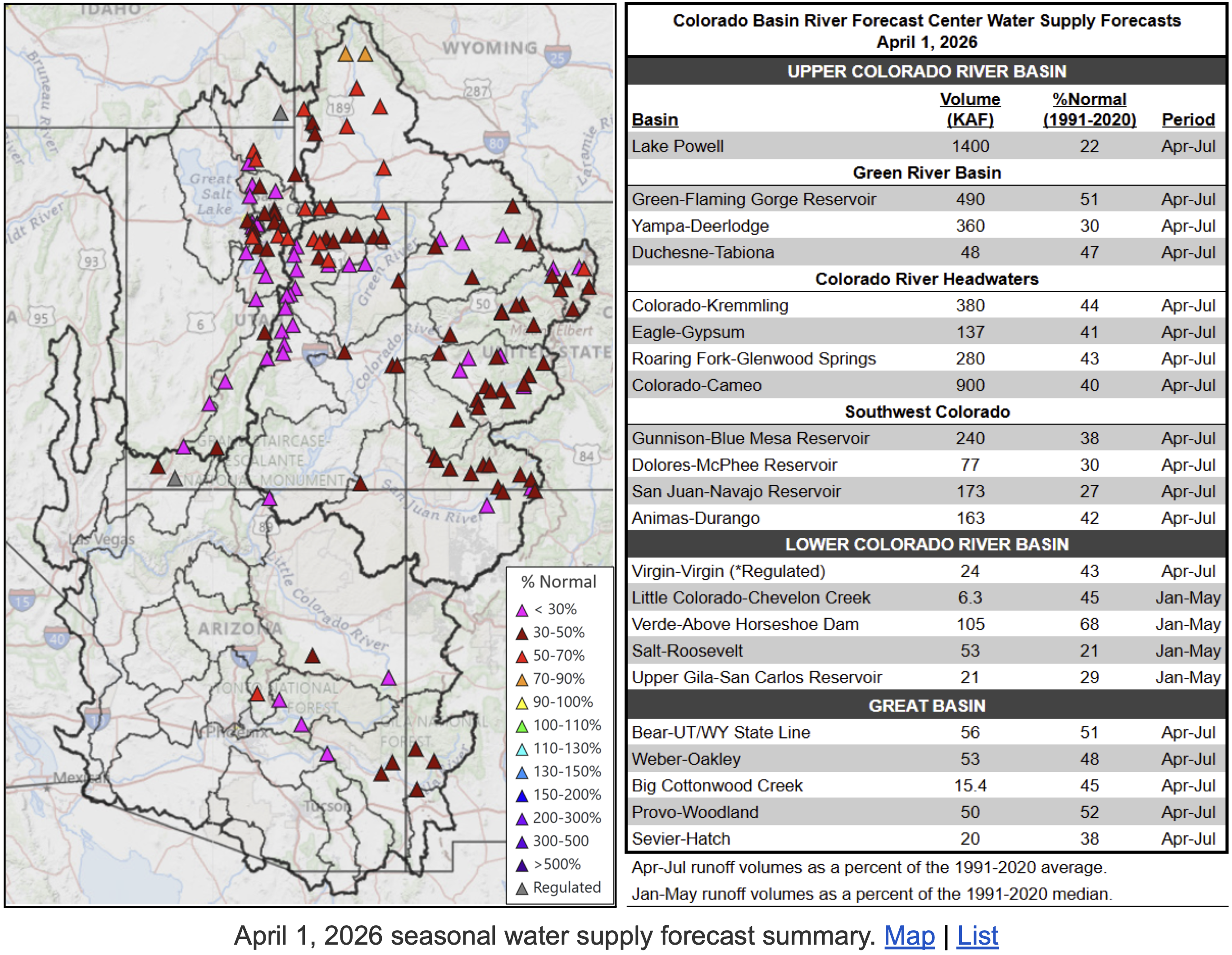
As a result, the Bureau of Reclamation is anticipating that inflow to Lake Powell will be 29% of the historical average, which it reports is one of the lowest on record. If water levels fall below a certain elevation — below 3,490 feet or roughly 15% of its capacity — it can impact operations, regional power and water supplies as well as reduce hydroelectric power generation. The Bureau is projecting it could hit this minimum power pool level by August. As of April 19, Lake Powell and Lake Mead were 24% and 32% full, respectively.
View below Flaming Gorge Dam from the Green River, eastern Utah. Photo credit: USGS
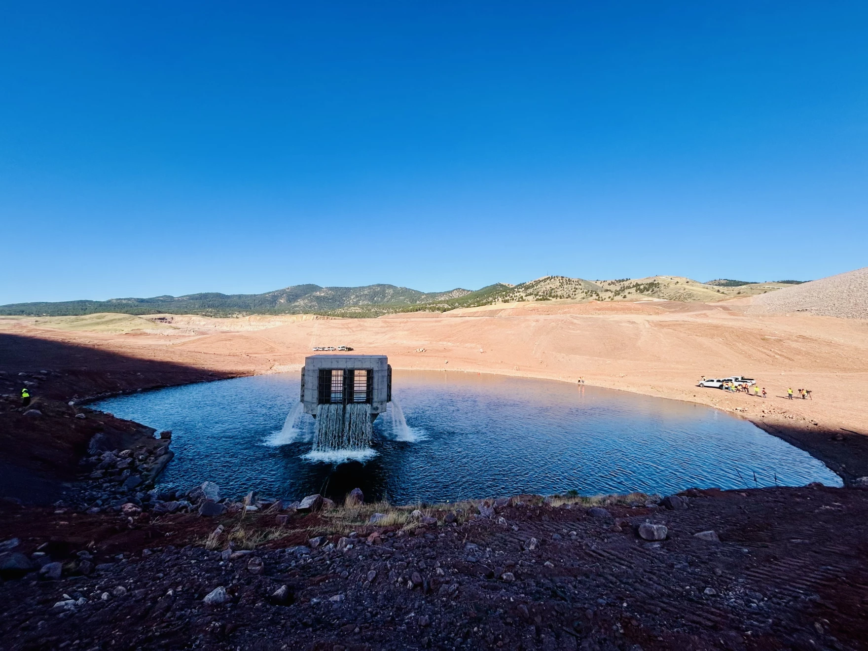
Water starts to fill Chimney Hollow Reservoir in Larimer County on Tuesday, April 21. Scott Franz/KUNC
Click the link to read the article on the KUNC website (Scott Franz):
April 22, 2026
At 8 a.m. Tuesday, there was only silence and the occasional crunch of rocks as a dozen people in orange vests waited in a moonlike landscape beneath a 350-foot-tall dam near Loveland.
“Ninetey seconds,” a worker called out.
Moments later, it sounded like a waterfall suddenly roared to life as Northern Water started filling Colorado’s newest reservoir, Chimney Hollow.
“It’s pretty cool, I mean it’s something we’ve been working on for a long time, so just to see it for real, it’s pretty cool,” Chris Manley, a water quality specialist with Northern Water, said as he watched water gush from a 40-foot-tall concrete tower at the bottom of the reservoir.
By the end of the week, the initial release of 1,500-acre feet of water will rise about 30 feet above the spot Manley and a gaggle of journalists were standing on Tuesday morning.
Engineers will make sure the pipes that will funnel Colorado River water to the reservoir are functioning correctly. It will also give Northern Water a chance to study an issue with the water supply.
The reservoir’s future became murky last year after officials announced that naturally occurring uranium was found in the rock used to build the dam for the reservoir.
Manley said the uranium discovery has set the project back roughly a year. But he said it is an issue Northern Water can manage long term.
Water from Chimney Hollow Reservoir is projected to serve almost a million people on the Front Range. Scott Franz/KUNC
“But we’ve got to really understand the situation a lot better before we can move forward,” he said.
This week’s initial fill will provide Northern Water with a real-world test of the water quality that was only previously done in laboratories.
None of the water coming into the reservoir will be released to taps at this point. The reservoir is only being filled to about 2% of its total capacity in the coming days.
“We’ll be measuring it actually pretty frequently, to see just what is (the water) picking up as it goes up and touches the dam and starts to move some of the sediments around here,” Northern Water spokesperson Jeff Stahla said.
Northern Water officials could not provide a timeline for when water will begin reaching the dozen water suppliers who have signed up to receive it.
Map from Northern Water
The reservoir project cost an estimated $500 million and has been in the planning stages for more than two decades.
Conservation groups have raised concerns about the reservoir.
“You can have a bunch of buckets, and you can build more buckets to put water on the front range,” Pelz said. “But the reality is, if the projected climate change impacts come to fruition — which all indications are, they’re coming to fruition quicker than we even thought — there’s going to be no water to fill those buckets.”
The reservoir is seeing its initial fill during historic drought conditions in the Colorado River basin.
“It’s definitely very ironic that we’re filling the reservoir in these historic drought conditions, but we’re fortunate that we had a little bit of supply left from last year,” Northern Water Operations Director Jerry Gibbens said. “It really showcases why storage is so important for our region.
Northern Water officials say the reservoir is a way to boost water security on the Front Range.
“As we’ve seen this year, water storage is such a key element of our overall water supply in northern Colorado, and this just adds another increment of that supply to a region where our water demands continue to grow,” Stahla said.
The South Platte River Basin is shaded in yellow. Source: Tom Cech, One World One Water Center, Metropolitan State University of Denver.
At an April 9 meeting, the Pagosa Area Water and Sanitation District (PAWSD) Board of Directors approved revisions to the district’s drought management plan. District Engineer Justin Ramsey opened discussion of the plan, which he explained was a complete rewrite of the previous plan and was adopted in 2020 with a stipulation that it be reexamined in 2026. He added that the district also had to implement the plan in 2025 due to dry conditions, which gave additional insights into how the plan functions. He explained that he recently reconvened the committee that drafted the plan, including PAWSD board members, water experts in the community, business owners and other community members. Ramsey stated that, although there were some changes recommended to the plan, it has, overall, been highly successful. He explained that the drought stages outlined in the plan are entered based on triggers, which are different depending on the time of year.
Early in the year, he stated, the triggers are the snowpack in the mountains, measured by the amount of snow water equivalent (SWE) at the U.S. Natural Resources Conservation Service SNOwpack TELemetry Network (also commonly known as SNOTEL) station on Wolf Creek Pass and the date when the district’s water supply is cut off on Four Mile Creek due to other senior water users diverting water…If specific SWE levels or a call on Four Mile do not occur by specific dates in the spring, the plan shifts to a different set of drought triggers based on water levels in Lake Hatcher (one of PAWSD’s primary reservoirs), water flows in the San Juan River and the drought stage for Archuleta County designated by the National Integrated Drought Information System (NIDIS). He explained that the amount of water in Lake Hatcher is weighted the most heavily, with flows in the San Juan being the next most influential factor and drought designation being the least. He added that the different drought stages come with different drought surcharges and water rate adjustments…He explained that the first drought stage (voluntary drought) aims to cut water use by 10 percent, while the most severe drought stage (stage four) is intended to cut water use by 50 percent.
On April 22, the Pagosa Area Water and Sanitation District (PAWSD) entered stage one drought under its drought mitigation plan, imposing new restrictions on irrigation and rate multipliers for high water use. The district’s drought plan calls for Conservation Service SNOwpack TELemetry Network (SNOTEL) site reaches zero between April 17 and May 1. SWE fell to zero on April 22, triggering stage one drought, according to PAWSD District Engineer Justin Ramsey. During drought stage one, irrigation is permitted only between 6 p.m. and 9 a.m., and residential customers who use more than 5,000 gallons of water a month will have a 1.25 times rate multiplier applied to their water bills. According to the PAWSD website, the imposition of this multiplier will begin to impact customer bills received in May, although the irrigation restrictions will start immediately. The plan notes that gardens may be hand watered using a hose or drip irrigation.
Drip irrigation graphic via Sonoma County Nurseries Resource
The Colorado River carves through mud left behind from Lake Powell when the reservoir was at full pool, near Hite, Utah in October 2022. (Alexander Heilner/The Water Desk with aerial support from LightHawk)
This year’s historic winter of low snow might feel novel. But recent years give some insight into just how dry the West’s most important river system can get. This season’s scant snowpack is melting rapidly, and turning up memories of other notably dry years.
Prolonged drought conditions and warming temperatures since 2000 have produced severe single-year droughts in 2002, 2012, 2018 and 2020 in the river’s headwaters states of Colorado, Wyoming and Utah. As severe drought years continue to put the Southwest’s water infrastructure to the test, communities in the region are grappling with how best to understand and adapt to a changing climate.
2002 stands as the worst drought on record for the Colorado River, measured as the flow into one of its biggest reservoirs, Lake Powell on the Utah-Arizona border. It’s possible 2026 could break that record. Back then the year acted as a wake-up call to the region’s water leaders, spurred important policy changes, and reshaped attitudes around conservation.
We asked Colorado River experts Eric Kuhn, Jeff Lukas and Jim Lochhead to share five important takeaways from the 2002 drought, and what to know as we enter the warmer, drier months of 2026.
1. Reservoirs have memory
Reservoirs act as batteries for water availability, charged by inputs such as snowmelt, streams, rivers and precipitation.
“What you did two or three years ago can affect your water supply now,” said Eric Kuhn, former general manager for the Colorado River Water Conservation District. “So in a good year, if you are conserving, you are actually helping the system out for the next drought.”
The 2002 drought prompted municipal utilities to rethink their reservoir usage.
“Water managers and agencies have absorbed several lessons from 2002, including holding something back. They’re operating the reservoirs a little differently,” said Jeff Lukas, an independent climate and water researcher who has lived on Colorado’s Front Range for 40 years.
By conserving reservoir water, municipal utilities can maintain water storage for less abundant water years of the future. But as dry conditions have dogged the entire Colorado River basin for more than a quarter-century, the system’s buffer is gone.
“The biggest issue is that Lake Powell and Lake Mead were relatively full in 2002,” Kuhn said. Now, both Lake Powell and Lake Mead are at critically low levels, and the water scarcity is increasing the likelihood of multi-state litigation.
In 2002, drought was dealt with on a local level; water utilities were not thinking about drought in terms of the entire river system, but instead how to regulate municipal water use. This year’s dry conditions are pushing the whole region to the brink.
2. Conservation can make a big difference, if it is mandatory
Individual contributions to water conservation, adhering to local outdoor watering restrictions for example, can make a difference. Prompted by the 2002 drought, a 2004 University of Colorado study aimed to measure the effectiveness of water restrictions put in place by water providers on the state’s populated Front Range.
The study followed municipal water providers Thornton, Aurora, Westminster, Fort Collins, Boulder, Louisville, Lafayette and Denver Water, comparing 2002 usage to average water usage in 2000 and 2001. Researchers determined that water restrictions are most effective when mandatory. Mandatory restrictions in Lafayette reduced water usage by as much as 53%, according to the study.
The same study found that under mandatory restrictions, savings of expected water use per capita was as successful as 56%, while voluntary restrictions only measured up to 12%.
Outdoor watering represents a big slice of a city’s water budget, and 2002 showed utilities that in times of crisis people can rein in their use.
“Everyone should realize that they can make a small contribution to the solution,” Kuhn said. “Even though their individual contribution might be miniscule, when you add up all their neighbors and other people, it’s not miniscule. It’s very, very big.”
Watering a lawn once or twice a week, and not during peak hours, is a practical way to conserve water while keeping grass alive.
3. This is not a one-off year
It’s easy to shrug off a dry year and hope for wet weather’s return. But the long-term trends are concerning.
“This is really the 26th year of extreme drought,” said former Denver Water CEO Jim Lochhead. On a larger scale, the seven Colorado River basin states—Arizona, California, Colorado, Nevada, New Mexico, Utah and Wyoming—have been preparing for worsening drought conditions since the shock of 2002. But river policy hasn’t kept pace with the aridification, leaving the region’s largest reservoirs at near record lows.
The Colorado River flows through canyons in northern Arizona in October 2020. (Ross Rice/The Water Desk & LightHawk)
“This has been a slow moving train that I think the states have known was coming, and they have frankly failed to do anything about it,” said Lochhead, who also represented the state of Colorado amid interstate Colorado River negotiations in the 1990s and early 2000s.
The Colorado Climate Center anticipates droughts to increase in severity and frequency, a trend that is only expected to continue in Colorado and across the Southwest as warming temperatures upend the water cycle.
“We should be managing and thinking about water, using water, as though it were always a drought,” Lukas said.
4. Communities have more practice dealing with drought, but still struggle
Drought conditions in 2002 led some municipal water utilities to organize and create incentives for conservation, and transformed the urban landscape, swapping grass for more drought-tolerant plants. Those water restrictions allowed municipal water providers to curb water demand while steadily growing in size. However, there is still room for improvement in disproportionately affected communities.
According to Lochhead, urban areas need to prioritize heat reduction in neighborhoods that have fewer trees in order to lessen the impacts of drought and warming temperatures. Using scarce water supplies to encourage tree-planting and increase shade should remain a priority.
“I think we need to work with those communities to enhance some landscaping,” Lochhead said. “Whether it’s the homeless population, whether it’s just kids that are out, whatever it may be, those areas are where they’re pretty hard hit by heat.”
Farmers and ranchers are used to riding the highs and lows of western weather. But extremely dry years like 2002, and now 2026, can push their operations to the limits.
“This is going to be a really tough year,” Lukas said. “You’re going to have a lot of people selling off their herds and taking insurance out because of low crop yields.”
The majority of Colorado’s annual water supply is used for irrigation, so any proposed restrictions can be costly for the agricultural community. “There are going to be a lot of farms and ranches that just can’t operate because they don’t have any water,” Lochhead said. “There are going to be some significant economic consequences.”
5. Stay aware, even if things seem bleak
For Lukas, this year and its predecessors test our expectations about what nature can provide.
Even in periods of prolonged drought, there are wet years. “Judging from history, that tends to put everyone back on their heels, a little complacent,” Lukas said, but maintaining water storage relies on year-to-year vigilance, not complacency.
Another primary concern during drought years is wildfire. With less moisture in the soil, dry vegetation acts as fuel for wildfire, which becomes harder to contain under hot and dry conditions.
“I worry a lot less about municipal water supply than I do about wildfire,” Lukas said. Many of Colorado’s notably dry years have also recorded severe and destructive wildfires.
It comes at no surprise that worsening drought falls in line with worsening wildfires. “Climate change is delivered to people through changes in the hydrologic cycle,” Kuhn said, so being aware of water usage now is just as, if not more important as it was in 2002.
This story was produced and distributed by The Water Desk at the University of Colorado Boulder’s Center for Environmental Journalism.
The federal government ordered Flaming Gorge water released and cuts to Lake Powell releases, to prevent collapse.
Last week, the federal government ordered emergency measures to prevent water levels at Lake Powell from falling so low that Glen Canyon Dam, which created the reservoir, could no longer generate power or deliver water downstream. Without this intervention, models showed that the reservoir could drop below safe operating levels in August, meaning that the river would not have a reliable way to flow past the dam. This would threaten water and power supplies for millions of people across the Southwest, as well as the flow of water through the Grand Canyon.
Westwide SNOTEL basin-filled map April 24, 2026.
Across the Colorado River Basin, an extremely low snowpack combined with a record-shattering March heat wave, have left water managers with few other options. The region’s reservoirs were already depleted from years of relying on wet winters to balance the growing demand with the ongoing drought.
Flaming Gorge Reservoir, on the Green River, straddles the Wyoming-Utah border south of Rock Springs. The Flaming Gorge dam, on the Utah side, was completed in 1964 and is a critical component of the Colorado River water storage system. The Green River, the chief tributary to the Colorado River, originates in the Wind River Range, flows to Flaming Gorge Reservoir, then connects with the Colorado River in Canyonlands National Park in Utah.
“This is a short-term solution,” said Jenny Dumas, water attorney for the Jicarilla Apache Nation, which sits near the border of Colorado and New Mexico. “It’s going to take time to recover these reservoirs before we can do this again. So while we can exhaust our reserves to avoid system collapse this year, it means reserves won’t be there next year.”
This is not the first time water managers have turned to Flaming Gorge to stabilize the larger river system. In 2022, the federal government ordered the reservoir to release 550,000 acre-feet to stabilize the downstream river system, which disrupted recreation and rattled upstream communities. This time, Reclamation has authorized releases of up to 1 million acre-feet. Over the next year, a third of the reservoir’s storage is expected to be gradually released. By September, water levels are projected to drop about 12 feet.
Flaming Gorge Reservoir stores water from the Green River in Wyoming, and is shared by Wyoming and Utah. Ted Wood/The Water Desk
“This is an unprecedented release volume — more than double the last time,” said Amy Haas, executive director of the Colorado River Authority of Utah, who briefed communities bracing for the releases at Flaming Gorge Reservoir. “We really just don’t know the actual impacts of these releases to surrounding communities, and our water users are struggling. My goodness, we are on target to become one of the worst water years on record. The forecasts are stunning to all of us.
The amount of water projected to flow into the river from snowmelt is rapidly declining. Over the first two weeks of April, forecasts for Lake Powell fell by 500,000 acre-feet. The spring forecast is shifting so quickly, some experts believe the releases from Flaming Gorge may need to increase.
“I think it’s a target, and they’re going to have to revise it,” said veteran water manager and researcher Eric Kuhn, who co-authored a paper last September predicting this kind of shortage and calling for action. “It’s many river miles from Flaming Gorge to Lake Powell. What are the transit losses?”
“Also, when March looked like June, what are June and July going to look like?” he added. “I could easily see that 1 million becomes 1.5 million acre-feet by March of 2027.”
Kuhn sees the emergency actions as a sign of broader failure to address the underlying issues that led to the current situation. “The Department of Interior no longer acknowledges that the fundamental problem is climate change. We’re dealing with the symptoms of the disease. We’re not dealing with the underlying problem,” he said. “The law of the river was written for a river that no longer exists from a hydrologic standpoint.”
In a meeting Tuesday, Upper Basin state commissioners acknowledged the need for emergency action but warned that this was not a long-term solution.
“I want to make darn sure people understand … the incredibly difficult, heartbreaking decisions that are having to be made with the lives of generations of cattle production, and farming communities in the Upper Basin states,” particularly in Utah, said Gene Shawcroft, Utah’s Colorado River commissioner.
Wyoming Commissioner Brandon Gebhardt reported that 13,000 acres of agricultural land in the South Piney drainage on the eastern slopes of the Wyoming Range had been cut off from water, adding that even some of the state’s oldest and most senior water rights — some dating to 1898 — will likely be impacted.
“We expect three of the five Flaming Gorge boat ramps in Wyoming will be rendered unusable, and low reservoir levels will have long-lasting negative impacts on reservoir fisheries,” said Gebhardt. “We recognize what we are approving today will have significant negative impacts on our water resources, local economies and recreation.”
Map of the San Juan River, a tributary of the Colorado River, in Arizona, Colorado, New Mexico and Utah, USA. Made using USGS National Map data. By Shannon1 – Own work, CC BY-SA 4.0, https://commons.wikimedia.org/w/index.php?curid=47456307
Shortage is affecting more than agriculture and recreation. The Ute Mountain Ute Tribe, for example, reported its sacred springs going dry, affecting ceremonies, and the tribal farm will have to operate with just 14% of its normal water supply. Meanwhile, the Jicarilla Apache Nation said it received just 25% to 35% of its contracted water allocation, leaving tribal leaders uncertain about whether they can divert enough water from the Navajo River to meet the community’s domestic needs.
With no sign of long-term agreement on how to manage the river past September, legal tensions among the basin states remain high.
Arizona’s Department of Water Resources released a statement agreeing with plans to order upstream releases to stabilize Lake Powell but also warning that the revised downstream releases were “substantially less than required under the 1922 Colorado River Compact,” referencing the foundational legal document dividing the river. “Failure to comply,” the release stated, “is itself a serious development that Arizona will assess and respond to accordingly.”
Upper Basin state commissioners plan to hold a special meeting to revisit the issue and vote on whether to continue emergency actions past August after assessing water levels and determining whether or not the releases are working.
Regardless of the possible legal battles, the reduced water in the river, infrastructure limits and political gridlock have left basin communities feeling uncertain about their future water security. After the planned releases from Flaming Gorge, if next winter brings another dry year, it is unlikely that upstream reservoirs will have enough water to stabilize Lake Powell.
The basin needs more than emergency actions, Dumas said. “We really want to emphasize the need for serious and permanent changes in how we use and manage the river to adjust to current and future hydrology.”
This story was produced by High Country News, in partnership with The Water Deskat the University of Colorado Boulder’s Center for Environmental Journalism.
Illustration from the report, “Antique Plumbing & Leadership Postponed” from the Utah Rivers Council, Glen Canyon Institute and the Great Basin Water Network. Courtesy of Utah Rivers Council
Click the link to read the article on the Aspen Public Radio website (Caroline Llanes). Here’s an excerpt:
April 21, 2026
The agency announced on April 17 that it would release between 600-thousand and one million acre feet of water from Flaming Gorge Reservoir on the Wyoming-Utah state line over the course of the next year. In addition, Reclamation will reduce the amount of water it sends from Lake Powell through Glen Canyon Dam, decreasing flows downstream through the Grand Canyon and into Lake Mead. Through September 2026, the agency will reduce its annual release volume from about 7.5 million acre feet of water to just 6 million acre feet.
Westwide SNOTEL basin-filled map April 23, 2026.
The drought contingency actions come in response to a water year that has been incredibly dire for the Western United States and the Colorado River Basin. Snowpack has been at record lows for much of the winter, which is bad news for a region that relies on snowmelt for much of its water use. The forecast for runoff into Lake Powell from the entire Upper Basin is forecast to be just 23% of normal. The agency estimates that these combined actions will boost Lake Powell’s elevation by 54 feet over the course of the year, bringing it to 3,500 feet in April 2027. Currently, Lake Powell’s elevation is about 3,528 feet. 3,490 feet is the elevation at which hydropower can no longer be produced at Glen Canyon Dam. Any lower, and water will not be able to enter the hydroelectric turbines. Instead, the water has to go through what’s called “river outlet works,” which are tunnels that bypass the turbines to get the water downstream to the Colorado River.
The back of Glen Canyon Dam circa 1964, not long after the reservoir had begun filling up. Here the water level is above dead pool, meaning water can be released via the river outlets, but it is below minimum power pool, so water cannot yet enter the penstocks to generate electricity. Bureau of Reclamation photo. Annotations: Jonathan P. Thompson
Seth Arens, a hydrologist at the Western Water Assessment, said Glen Canyon Dam was not designed to have the river outlet works as the primary way to get water out of the reservoir.
“When the Bureau of Reclamation has used those river outlet tubes, most of the times they’ve used them, there’ve been some damage to those tubes,” he said. “They’ve had to repair damages after relatively short uses, you know, a scale of weeks dumping water out of those.”
Environmental attorney Chris Winter said it’s clear Reclamation has to take emergency actions to protect its own infrastructure. But, he said the plan leaves a lot of uncertainty and unanswered questions.
“We’re not going to be able to release a whole bunch of water from Flaming Gorge Reservoir (next year) because that water will have been released this year, and it’s not going to refill if we get another dry year,” he said. “Releases of water from Upper Basin storage units, that’s like a one-time thing, unless we happen to get some wet years in the future.”
View below Flaming Gorge Dam from the Green River, eastern Utah. Photo credit: USGS
Flaming Gorge is currently about 82% full. Reclamation estimates that its plan will bring the reservoir down to about 59% of its full capacity over the next year. Other Upper Basin reservoirs are not part of the plan at the moment, due to poor forecasted inflows and low water levels. Blue Mesa Reservoir in Western Colorado is currently 47% full and Navajo Lake on the Colorado-New Mexico state line is 63% full. Winter said reducing flows out of Glen Canyon Dam could also lead to legal issues. The Upper Basin states of Colorado, Utah, Wyoming, and New Mexico have not reached a deal with the Lower Basin states of Arizona, California, and Nevada on how to allocate water—and take cuts to usage in the midst of a changing climate—over the next 20 years. On top of that, reducing flows this year would mark a fulcrum point: the first year that the amount of water at Lees Ferry, just below Glen Canyon Dam, falls below the averages set by the Colorado River Compact of 1922.
Denver Water’s collection and service areas continue to face severe drought conditions, with historically low snowpack. Denver Water depends on mountain snowpack for its water supply, which serves 1.5 million people in Denver and surrounding suburbs.
As a result, on March 25, 2026, the Denver Board of Water Commissioners declared a Stage 1 drought, seeking a 20% reduction in water use to preserve water levels and avoid even stricter mandatory restrictions later this summer. On April 8, 2026, the board approved the implementation of temporary drought pricing, starting with May water use and reflected in June bills, to signal the premium value of water during droughts and help incentivize customers to save water.
Customers are urged not to turn on automatic sprinkler systems until at least mid- to late-May, or later if possible. It is not necessary to water grass two days per week in April and the beginning of May; keeping automatic systems off will help save water. Occasional hand-watering may be necessary for trees and shrubs during this time. Keep an eye on the weather and let Mother Nature do the watering when she delivers spring rains.
Comment from Nathan Elder, Denver Water’s manager of water supply:
“The snow we saw last week brought marginal improvement to snowpack, but it’s still the worst on record, which is doubly concerning as this week is typically our spring peak when the snow levels are the highest. We need our customers to reduce their water use by 20% and help stretch the water we have stored in our reservoirs. Hopefully, working together, we can save water across our service area and avoid increasing restrictions later this summer.”
In Denver Water’s collection system, snowpack as of April 20, 2026, remained at the lowest levels observed in the past 40 years:
Colorado River Basin: 36% of normal, worst on record.
South Platte River Basin: 7% of normal, worst on record.
Snowpack and melting conditions are unprecedented, with accelerated melting seen since mid-March. Customers need to save water to protect the supply we have right now.
Streamflow forecasts are calling for runoff levels to be 10-40% of normal in 2026.
Reservoir storage conditions are below average; while in reasonably good shape for the time being, far less snowpack is available to help refill them. As of April 20, 2026, reservoirs were 80% full, versus an average of 85% full for this time.
Customers are urged not to turn on automatic sprinkler systems until at least mid- to late-May, or later if possible. When watering season begins, Denver Water will require customers in single-family residential properties to limit watering to no more than two days per week on a set schedule based on their address.
Addresses ending in even numbers: Sunday and Thursday.
Addresses ending in odd numbers: Wednesday and Saturday.
All other customers, including multifamily properties, commercial properties, homeowners associations and government properties, may water only on Tuesdays and Fridays.
Water only during cooler times of the day, between 6 p.m. and 10 a.m.
Do not allow water to pool in gutters, streets and alleys.
Do not waste water by letting it spray on concrete and asphalt.
Repair leaking sprinkler systems within 10 days.
Do not irrigate while it is raining or during high winds.
Use a hose nozzle with a shut-off valve when washing your car.
For its part, Denver Water has proactively reduced its spending, taking steps that include enacting a hiring freeze and reviewing maintenance and other projects to see which ones could be deferred. We are also looking into other ways to increase supply by activating agreements that allow us to capture additional water that is typically unavailable during normal conditions.
This year marks the fifth time since 2000 that Denver Water has issued a Stage 1 drought, and the first since 2013. Prior to 2013, the board declared a Stage 1 drought in 2002, 2003 and 2004.
Denver Water has many resources for homeowners looking for inspiration and information about landscapes that fit naturally into our dry climate. Click here for conservation and efficiency tips for outdoor irrigation and to get more details on ways to ColoradoScape your property, including through rebates for turf removal and a DIY guide for landscape changes, among many other potential water-saving steps.
Updates about Denver Water’s reservoir levels, customer water use and snowpack can be found in the Water Watch Report, which is updated weekly in the spring and summer.
This chart shows the cumulative snowpack on April 20, 2026, in the area of the Colorado River Basin where Denver Water captures its water supply. The snowpack is 36% of normal, which ranks as the lowest on record for April 20. Image credit: Denver Water.
This chart shows the cumulative snowpack on April 20, 2026, in the area of the South Platte River Basin where Denver Water captures its water supply. The snowpack is 7% of normal, which ranks as the lowest on record for April 20. Image credit: Denver Water.
Click the link to read the article on the KJZZ website (Alex Hager). Here’s an excerpt:
April 21, 2026
The nation’s second-largest reservoir will get a boost to keep water levels from dropping too low, but the fix won’t last long…The Bureau of Reclamation will take water from Flaming Gorge Reservoir in Utah and Wyoming and send it downstream to Lake Powell. The agency, which manages major dams and reservoirs across the Western U.S., will also ratchet back the amount of water released from Lake Powell. The efforts are mainly focused at keeping Glen Canyon Dam running smoothly. If water levels drop much further, Lake Powell’s surface will fall below the intakes that pull water into hydropower generators within the dam…Water levels had been forecast to drop below the hydropower intakes level as soon as this summer…
Illustration from the report, “Antique Plumbing & Leadership Postponed” from the Utah Rivers Council, Glen Canyon Institute and the Great Basin Water Network. Courtesy of Utah Rivers Council
Reclamation’s plan will likely stave off catastrophe at Glen Canyon Dam, but it will do little to solve the problem that imperiled it in the first place. Climate change has left the river with less supply, and humans have not been able to adequately rein in demand.
“This action that’s being taken is a band-aid solution for a gaping wound,” said Eric Balken, executive director of the nonprofit Glen Canyon Institute. “It’s a short-term measure that does not get at the root of the problem, which is over consumption of water.”
The Grand Canyon survey party at Lees Ferry. Left to right: Leigh Lint, boatman; H.E. Blake, boatman; Frank Word, cook; C.H. Birdseye, expedition leader; R.C. Moore, geologist; R.W. Burchard, topographer; E.C. LaRue, hydraulic engineer; Lewis Freeman, boatman, and Emery Kolb, head boatman. Boatman Leigh Lint, “a beefy athlete who could tear the rowlocks off a boat…absolutely fearless,” later went to college and became an engineer for the USGS. The Grand Canyon survey party at Lees Ferry in 1923. (Public domain.)
It’s been a record dry winter across the West — and it’s making an already bad situation on the Colorado River even worse. If water levels get any lower, Lake Powell and the dam that holds it back could be in dire straits. So now, the federal government is stepping in to prop up water levels. But, as KJZZ’s Alex Hager reports, it could be a Band-Aid solution to a much bigger problem. Hager joined The Show to explain.
LAUREN GILGER: Good to have you. So, what’s the situation on Lake Powell right now after this really dry winter? Kind of a worst-case scenario almost.
ALEX HAGER: Well, right now water levels there are forecast to drop to dangerously low levels as soon as this summer. And when I say dangerous, that means we would start to see some of the infrastructure in Glen Canyon Dam, which is up in Page, Arizona, start to fail. So water levels are on track right now to drop below the intakes for the hydropower turbines that sit inside the dam. That means it would become difficult or impossible to spin them and make electricity for 5 million people across seven states. If water drops a little bit further than that, it might not be able to pass through the dam at all. We are already looking at — you know, if it falls below that hydropower intake, it could only travel through this little-used set of backup pipes. We don’t know that it could carry enough water through. You start to have all of these problems. So we are seeing some actions to prevent that from happening now.
LAUREN GILGER: OK. So tell us about those actions. This is the federal government sort of taking control of at least this aspect of it. What are they going to do?
ALEX HAGER: That’s right. The federal government is stepping in. It is kicking into action something of an emergency backup plan. It’s been done before, but it is definitely a backup plan. And they’re going to shuffle some water around. There is another big reservoir up in Utah and Wyoming called Flaming Gorge, and they’re going to release extra water from Flaming Gorge, send it down the Colorado River to help fill up Lake Powell. At the same time, they’re going to start tightening the tap on Lake Powell, meaning that less water comes out of it. That water will — less of it will flow into the Grand Canyon downstream to Lake Mead and downstream to us.
Map of the Colorado River drainage basin, created using USGS data. By Shannon1 Creative Commons Attribution-Share Alike 4.0
The back of Glen Canyon Dam circa 1964, not long after the reservoir had begun filling up. Here the water level is above dead pool, meaning water can be released via the river outlets, but it is below minimum power pool, so water cannot yet enter the penstocks to generate electricity. Bureau of Reclamation photo. Annotations: Jonathan P. Thompson
A bad year in the Colorado River Basin – barring a truly miraculous spring, probably the worst in recorded history. It is bad enough so the Bureau may have to stop creating power from the Glen Canyon powerplant by this coming fall. At that point, the only way to get water downriver from Glen Canyon Dam will be dribbling it through four outlet tubes that the Bureau is now wishing it had built differently (better) 65 years ago. And praying for enough precip to push the level back above the danger point for the turbines.
Meanwhile the negotiations between the seven basin states about the future distribution of the water remained at an impasse. One might think that a really bad year might generate some new thinking, but the two Basins are still debating Compact numbers like 7.5 million acre-feet for the Lower Basin with a river that might produce less than 5 maf this year, and maybe not much more than that more frequently in the future.
It should be obvious by now that any further negotiation between the states needs to have an independent facilitator guiding the discussion, pushing both factions to disassemble their own non-negotiables. A hard-ass facilitator speaking on behalf of river reality. [ed. emphasis mine]
It seems likely that we will go into the 2027 water year this fall with some new ‘interim plan’ for operating the river system for the water year that begins in October – probably some mix-and-match from the Bureau’s five alternatives proposed last year and ‘EISed’ while the seven states fiddled. The real purpose of the new interim plan will be to keep the infrastructure of the river system viable – dancing with the dead pool. This will probably impose serious delivery shortages on those below the Powell and Mead Reservoirs (meaning the Lower Basin), and also drop the Upper Basin’s rolling 10-year total closer to the 75 million acre-feet (maf) that will cause the ‘compact call’ threat to rear its ugly head.
Year-to-year might be the most honest approach now, anyway, getting a habit of feeling our way forward carefully, with our eyes wide open – woke, one might say. The managerial ‘need for certainty’ in projections may not be part of the future we’ve imposed on ourselves.
But that’s a good place to let the present sit and settle, and go back to the unfolding saga of the ‘Era of Conquest’ in this update of Fred Dellenbaugh’s Romance of the Colorado River. You may remember that in the last post here, I related that the Bureau of Reclamation, feeling much loved for the Boulder Canyon Project that watered, fed and powered a massive regional development in Southern California, came out of World War II ready to do the same for the Compact’s Upper Basin, in response to a mandate in the Boulder Canyon Project Act that a plan be developed for the development of the rest of the river.
There was, however, already quite a lot of development going on in the Upper Basin – at least in the state of Colorado, beginning in the 1930s, simultaneous with the Boulder Canyon Project.
Udall/Overpeck 4-panel Figure Colorado River temperature/precipitation/natural flows with trend. Lake Mead and Lake Powell storage. Updated through Water Year 2025. Note the tiny points on the annual data so that you can flyspeck the individual years. Credit: Brad Udall
To establish context – the whole Colorado River Basin was experiencing its first serious modern-times drought, even as the Great Depression was settling over the whole nation. After the ‘pluvial’ of water abundance in the first three decades of the 20th century, which convinced the water mavens that the river would deliver a dependable-enough flow of nearly 18 maf, the basin experienced its first 5 maf flow in 1933; by the end of the 1930s, there was reason to doubt that the river would ever again average 18 maf.
But Colorado had a special problem to resolve about Colorado River water distribution: the transdivide situation. I will not bore you again with my opinion of the imperial arrogance in randomly laying down straight line state boundaries in a region of great geographic and geological diversity. But what this created in the irrelevant rectangle called Colorado was like a blanket laid over a fence – the fence being the Continental Divide. West of the Divide, precipitation that fell (mostly snow in the winter) all ran off toward the Pacific Ocean in the Colorado River tributaries. East of the Divide, it all ran off toward the Atlantic in the Platte, Arkansas and Rio Grande Rivers. Because the weather mostly rode in on the prevailing westerlies, considerably more precipitation fell on the West Slope than fell on the East Slope. But the vagaries of cultural and economic development put most of the population and economic growth on the East Slope – ‘80 percent-20 percent’ is the rough ratio frequently used to describe the imbalance between water and population in the blanket dropped over the fence.
The distribution of water on both sides of the ‘blanket’ was governed by the appropriation doctrine as stated in the Colorado Constitution: all the water in the state belongs to the people of the state, subject to appropriation for individual use, and the right to divert ‘shall never be denied’ – with seniority among users determining the right to use the water in times of shortage. And by the turn of the century, challenges in water court had established the right to divert water from one basin to another.
As the drought of the 1930s settled in, farmers on the East Slope began to experience serious pressures on the water supply. And consistent with the optimism and technological advances of the early 20th century, this was not regarded as a fact of life to be acknowledged and adapted to, but as a problem to be addressed – in this situation, by moving water from the West Slope. A major task – but Franklin Roosevelt’s ‘New Deal’ efforts to alleviate the Great Depression offered the possibility of some help, through new agencies like the Reconstruction Finance Corporation and the Public Works Administration.
So when the Colorado General Assembly gathered early in 1933, two water project bills were in the hopper: one to divert an unspecified quantity from the Upper Colorado River in the Grand Lake area to the South Platte River basin, and one to divert an unspecified quantity from the Gunnison River to the Arkansas River basin.
Inhabitants of the West Slope, however, knew nothing about this until they read about it in the newspapers. And they were even more surprised that summer when construction actually began on two transdivide projects: the Denver Water Board began constructing a system of small canals high in the Fraser River headwaters (Upper Colorado tributary) to bring water to the Moffat railroad tunnel pilot bore, which the Water Board had leased from the railroad – an unused but already dug ‘pipe’ to the northern Denver area. And the sugar-beet industry led by Great Western Sugar was doing the same collection system in the headwaters of the Roaring Fork River above Aspen for diversion into a small tunnel to the Arkansas River basin. Both of those enterprises were self-funded.
All of this precipitated a regional West Slope meeting in Grand Junction of ‘water people’ – county commissioners and attorneys who were also all ranchers or farmers – at which a ‘Western Colorado Protective Association’ (WCPA) was formed, and a letter was drafted to the state engineer expressing concern that the proposed and in-process projects threatened the future development of the West Slope, and requesting inclusion in all future discussion of them.
The situation as the West Slope people saw it was not a ‘water grab.’ The leadership in the WCPA knew that the East Slope irrigators and city-builders were exercising a constitutional right in appropriating ‘the people’s water’ on the West Slope. They also knew that most of the Colorado River water left the state’s West Slope in an unmanageable snowmelt flood anyway, and it might as well go through a tunnel to the Front Range as through Grand Junction and on to – well, soon, on to enviable storage behind the great dam being built far downstream rather than its historical destiny of flowing on into the salty sea unused.
Storage! That was the key to the West Slope’s chief water problem, which was water available throughout the growing season for finishing as well as starting crops. West Slope engineers had been drafting up a number of reservoir-and-irrigation projects to present to the Bureau of Reclamation, but dams are expensive, and all of the proposed reservoirs served mountain-valley populations too small to pass the Bureau’s cost-benefit analyses.
So the concept of ‘compensatory storage’ for water lost through transdivide diversions became the WCPA’s central focus. And despite their small population, the WCPA had two good cards to play. One was the fact that New Deal federal funding distributed to the states had to be for projects approved by the entire state; the transdivide diversions that needed federal assistance needed for the basin of origin to be as happy as the basin of destination.
A image shows a guest column by Rep. Edward Taylor that appeared from the Steamboat Pilot in 1921. Graphic credit: Northern Water
The other card was a congressional representative, Edward Taylor, whom they had returned to Congress for 12 terms by 1933, and who had over that quarter-century ascended to chairmanship of the subcommittee that controlled the Interior Department budget in the powerful House Appropriation Committee. Congressman Taylor launched the WCPA’s ‘defensive offensive’ by saying that any project seeking federal assistance for a transdivide diversion would have to provide, as part of their project, an acre-foot of compensatory storage for the West Slope for every acre-foot to be diverted.
That was a large and very expensive demand. Taylor exempted Denver and its Moffat project from the mandate – because, he said, we all want to see ‘our capital city’ grow unrestricted. More likely, he knew that Denver could fund its own project and would at best just ignore him; he was not their congressman, and the Denver Water Board at that point was coming under the domination by their attorney, Glenn Saunders, a city-builder who envisioned a water supply for a ‘thousand-year city,’ most of which he thought would have to come from the West Slope. He just wanted the hicks to stay out of his way. (Not an exaggeration at all.)
Taylor could, however, impose his acre-foot-for-every-acre-foot demand on those seeking federal Public Works Administration funds or Bureau of Reclamation assistance. And that set up what is really an interesting story of people working out difficult problems they’ve imposed on themselves in draping a blanket over a fence and calling it a state, then adopting a wide-open appropriations doctrine for the distribution of a limited resource statewide. It’s a story with many moving parts that we don’t really have time for here in depth; I will note, however, that the whole story is told in my Water Wranglers book, the story of the development of Colorado’s share of the Colorado River. (Out of print, but copies supposedly in all Colorado libraries.)
The principal players in the story were the Western Colorado Protective Association (WCPA), led by Frank Delaney, a lawyer-rancher, and D.W. Aupperle, a Grand Junction lawyer and fruit grower; the South Platte Water Users Association (SPWUA), led by Charles Hansen, a newspaper editor in farm country and a couple lawyer-farmers; and of course the Bureau which wanted to do a big transdivide diversion to the South Platte River. And what turned out to be the ‘wild card,’ Congressman Taylor.
A seemingly endless series of meetings began between the WCPA and the SPWUA with the Bureau in attendance. There was fundamental agreement that, first, the East Slope had legal right to appropriate West Slope water, and second, that the East Slope owed the West Slope some compensation for diverting part of the West Slope’s base for future development. The challenge was arriving at the amount of compensation. The SPWUA wanted to divert more than 300,000 acre-feet from the Colorado River, for what became the Colorado-Big Thompson Project, but they did not see how (even if they could get some New Deal PWA financing) they could afford to also create that much West Slope storage. But the WCPA felt bound to support their congressman – without whom they really had no card to keep them in the game. Frustration and ire grew on both sides – compounded by having to travel back and forth either on the slow trains or drive on roads that were really ‘country’ (a major West Slope chronic complaint).
Finally, in the spring of 1936, Frank Delaney of the WCPA suggested a compromise. If the Bureau and SPWUA wanted to rush into construction, it would have to be Taylor’s acre-foot-for-an-acre-foot mandate. But if they could delay their project until the Bureau did a thorough study of what the loss of 300,000 af of free-flowing water (most of it annually leaving the state unused anyway) would be to the West Slope, and how much storage would actually compensate the West Slope users for that loss of spring runoff, the West Slope would accept that number (and work on getting Cong. Taylor to accept it).
The ‘Delaney Resolution’ broke the stalemate. The Bureau men spent months poring over existing rights and land maps (long before computers and spreadsheets), and came up with a need for 152,000 acre-feet of compensatory storage: 52,000 af to make sure that the Shoshone power plant water right above Glenwood Springs could be met year round (which would also ensure enough late season water for the Grand Valley farms and orchards), and 100,000 af for future irrigation and domestic water development.
That cut Taylor’s demand in two – and the Bureau planned to add a powerplant to the dam that would significantly reduce what the SPWUA would have to pay back. During this period, Taylor – an old man – was actually too sick to participate, and the Delaney Resolution was adopted for the Colorado-Big Thompson Project. (Taylor would die in office in 1941 – still believing that an acre-foot-for-every-acre-foot was what should be adhered to.)
Graphic credit: RogerWendell.com
The compromise process was codified as ‘Senate Document 80,’ part of the Colorado-Big Thompson Project Act passed in 1937. Senate Doc. 80 became part of all subsequent transdivide project planning – except where Denver was concerned; it wasn’t until the veto of Denver Water’s Two Forks Project half a century later that Denver Water finally conceded to take West Slope needs into account in its transdivide projects.
That process of working through a significant challenge to mutual benefit stands, in at least my mind, as one of the highlights of the Era of Conquest in the Colorado River region – a period not without occasional efforts measuring up to the often naive but high-minded vision driving the developers’ ‘romancing of the river’ – to bring deserts into bloom, to reshape unfriendly environments to accommodate individuals and their families willing to work at it. It is too easy to condemn that from this side where we reap the harvest of all the mistakes involved that they didn’t know about until they had made them.
Next post, we’ll look at what happened to that carefully forged intrastate resolution when serious Colorado River planning came to the Compact’s Upper Basin. Meanwhile – pray for monsoons, or just a good rainy spell.
Colorado transmountain diversions via the University of Colorado
Water from Antero Reservoir (pictured) will be moved to Cheesman Reservoir in 2026 to help with drought response. This measure was last taken in 2002. Photo credit: Denver Water.
In the coming weeks, Denver Water will begin moving water from Antero Reservoirto Cheesman Reservoir,as part of the utility’s drought response.
Antero Reservoir has the highest ratio of evaporation to storage of any of Denver Water’s reservoirs, and moving the water to Cheesman Reservoir will prevent about 5,000 acre-feet of water (about 25% of the reservoir’s storage capacity) from evaporating. One acre-foot of water equals the annual water use of about three to four single-family households a year.
“A lot of forethought and planning went into our collection system and reservoirs,” said Nathan Elder, manager of water supply for Denver Water. “Antero is a drought reservoir, designed to provide water to our customers during a severe drought. Consolidating this water into Cheesman will help us make the most of the water we have.”
Denver Water is working closely with Colorado Parks and Wildlife to minimize the loss of fish during this process and to allow the public to use the reservoir for a brief period before it eventually closes. Following the fish relocation process, there will be no recreation, including camping, allowed at Antero Reservoir in 2026. More details about this plan will be announced when it is finalized.
The decision also allows Denver Water to use more water from its South Platte River Basin supplies, reducing the need to pull as much water from sources west of the Continental Divide, which are also below normal levels following an abysmal snowpack and runoff season.
In a standard year, the water lost to evaporation is recovered by the next runoff season. Because of the historically low snowpack levels in 2026, the water lost this year would not have been recovered.
Drought conditions will determine when the reservoir can be refilled. The reservoir was also drained to assist with water management during the 2002 drought. There were plans to drain the reservoir as a drought response in 2013, though a series of late-season snowstorms allowed Denver Water to continue storing water in the reservoir. The last time Antero Reservoir was emptied was in 2015 for a dam rehabilitation project.
The South Platte River Basin is shaded in yellow. Source: Tom Cech, One World One Water Center, Metropolitan State University of Denver.
On April 1, 2026, the Indian Peaks Band of the Paiute Indian Tribe of Utah, represented by the Native American Rights Fund, filed a Notice of Appeal and Petition for Stay with the U.S. Department of the Interior, Office of Hearings and Appeals, Interior Board of Land Appeals (IBLA), challenging the Bureau of Land Management’s March 2, 2026, approval of the Pine Valley Water Supply Project.
The filing seeks review of BLM’s decision authorizing a large‑scale groundwater extraction and pipeline project in southern Utah and asks the IBLA to stay the project approvals while the appeal is pending. The Band argues that the decision violates federal law, including the National Environmental Policy Act, and unlawfully threatens the Band’s federally reserved water rights and culturally significant resources.
The Band’s former Reservation, which is on the ancestral lands of the Band, is located just a few miles west of the Pine Valley Water Supply Project’s proposed wellfield. The amount of water that the Cedar Valley Water Conservancy seeks to extract from the Pine Valley exceeds the amount of water available and will harm the Band’s water resources.
“These water resources are fundamental to our Band’s history, culture, and future,”said Chairwoman Tamra Borchardt-Slayton of the Indian Peaks Band of the Paiute Indian Tribe of Utah. “Federal law is clear that the Band’s water rights must be protected, and we are asking the Interior Department to do just that.”
The Indian Peaks Band holds federally reserved water rights associated with its former reservation lands under longstanding federal law. Those rights, which predate many other uses of water in the region, remain protected today and cannot be impaired by federal agency action. The appeal asserts that BLM failed to adequately consider these rights or uphold its federal trust responsibility to Tribal Nations before approving the project.
“Federal agencies have both a legal and moral obligation to protect Tribal water rights,” said NARF Staff Attorney Tom Murphy. “This appeal seeks to ensure that those obligations are honored for the Band’s water rights.”
The appeal and petition for stay were filed pursuant to 43 C.F.R. Part 4, which governs administrative appeals of BLM decisions. If granted, the stay would preserve the status quo and prevent construction or further project commitments while IBLA considers the merits of the appeal.
Roaring Fork Valley governments and fire and law enforcement agencies are gearing up for what is anticipated to be a much warmer and drier summer than normal. The Roaring Fork Valley is experiencing a “record breaking year” for drought, snowfall and snowpack, Erin Walter, a meteorologist with the National Weather Service, said during a press briefing Thursday with multiple local emergency management and fire leaders. The agencies are emphasizing both individual preparedness and cross-agency preparedness in hopes of mitigating wildfires or minimizing the damage of wildfires if they occur this summer.
“Wildfires are inevitable,” said Ali Hammond, director of wildfire resilience for Aspen Fire. “Wildfire disasters are preventable.”
Local leaders are encouraging individuals to make their own wildfire preparedness plans, like building a go-bag and establishing an evacuation plan. They’re also urging homeowners to harden their homes and ensure the first 5 feet around their homes is cleared of any vulnerable vegetation…Agencies across the valley are changing evacuation frameworks to “ready, set, go,” which they will use when notifying residents about wildfire risk in their area. They’re also trying to improve their messaging on wildfire risks, like red flag warnings and what different stages of a fire ban mean. Local officials are working to prevent wildfires from a number of angles. But it can be difficult under unprecedented circumstances. The city of Aspen is currently under stage two drought restrictions. Erin Loughlin-Molliconi, the city of Aspen’s utilities director, said the city is considering more stringent measures because of the persistent, dry conditions.
Difficult decisions for the Colorado River are starting to be made.
In what will be a defining year for the struggling watershed, the federal agency that manages the basin’s dams took unprecedented actions on Friday to store more water in Lake Powell in order to preserve hydropower generation and protect water-delivery infrastructure at Glen Canyon Dam that the agency says is at risk of damage due to low reservoir levels.
The April 17 announcement from the Bureau of Reclamation will also set in motion events that could result in first-ever lawsuits from Arizona, California, or Nevada against their upstream neighbors over water supply from the shrinking Colorado River.
The Central Arizona Project, which delivers Colorado River water to Phoenix and Tucson, called Reclamation’s actions “a band-aid” and urged the agency to release even more water from upstream reservoirs into Powell. CAP, because it has lowest water-rights priority in the lower basin, is the most vulnerable to proposed water cuts that would attempt to align water supply with demand.
“There is no time to delay,” Patrick Dent, CAP’s assistant general manager for water policy, told Circle of Blue two days before the announcement.
The Bureau of Reclamation will make two moves to support Lake Powell, the huge reservoir formed by Glen Canyon Dam that is less than 25 percent full and shrinking.
Utah, Colorado, Wyoming and New Mexico are asking the federal government to pause some releases from Flaming Gorge Reservoir, which straddles the border between Wyoming and Utah. The reservoir, pictured here in 2021, is the third-largest in the Colorado River system.
Reclamation’s first move is to release more water from Flaming Gorge, an upstream reservoir that is 82 percent full. With the consent of the four upper basin states, between 660,000 acre-feet and 1 million acre-feet will flow from Flaming Gorge into Powell over the next 12 months.
Reclamation previously used upstream reservoirs to prop up Powell in 2022-23, when some 463,000 acre-feet were released. These extra releases are supposed to be recovered if water supply conditions turn favorable. If more dry years are ahead, then the upstream releases will have been a one-shot intervention.
The agency’s second move is to hold back more water in Powell. Using authority granted in a 2024 decision, the agency will cut Powell’s water releases from 7.48 million acre-feet to 6 million acre-feet. This is the first time that Reclamation has invoked its Section 6(E) authority.
Water supply conditions in the basin worsened each month this year as hot, dry weather drained a meager snowpack that is on a downward trend due to manmade climate change. A heat wave in late March was the most extreme on record in the Southwest for that time of year. Inflows into Lake Powell this year are projected to be the lowest ever measured, breaking a record set in 2002.
The water elevation at Powell currently sits at 3,526 feet. Reclamation has stated that it will do what it can to prevent the reservoir from dropping below 3,500 feet. Hydropower generation stops at 3,490 feet. Without Reclamation’s announced interventions, that level is expected to be breached by August.
With the two interventions, Powell is projected, with average weather conditions, to remain above 3,500 feet by April 2027, but just barely. If the next 12 months continue to be hot and dry, more emergency actions might be necessary.
The back of Glen Canyon Dam circa 1964, not long after the reservoir had begun filling up. Here the water level is above dead pool, meaning water can be released via the river outlets, but it is below minimum power pool, so water cannot yet enter the penstocks to generate electricity. Bureau of Reclamation photo. Annotations: Jonathan P. Thompson
If Powell were to drop below 3,490 feet, water would have to be released through a smaller set of pipes called the river outlet works. Reclamation has said that using these pipes for extended periods of time is untested and risks damaging them.
Reducing outflows from Powell will have two effects. One is that Lake Mead, located downstream, will shrink more quickly, as will its hydropower output. Boating access will be more difficult.
The other consequence is the specter of litigation. The 1922 Colorado River Compact requires the four upper basin states – Colorado, New Mexico, Utah, and Wyoming – to deliver 75 million acre-feet over 10 years. Add in the upper basin’s share of the water required for Mexico and the figure rises to roughly 82.5 million.
Cutting Powell outflows this year to 6 million acre-feet will likely push the 10-year total below the required threshold.
Reclamation is not focusing on the legal implications, says James Eklund, a partner at Taft Law.
“Reclamation is essentially telling the basin states, ‘We are going to protect our billions of dollars’ worth of infrastructure, including Glen Canyon Dam, and if you believe that violates your compact entitlement, you know where the courthouse is’,” Eklund, a former Colorado River commissioner for Colorado, wrote to Circle of Blue.
States in both upper and lower basins have already set aside money for potential litigation or are considering it.
Still, a legal right does not necessarily mean the water is available, Eklund cautions. “No court can conjure acre-feet that aren’t in the reservoir.”
Udall/Overpeck 4-panel Figure Colorado River temperature/precipitation/natural flows with trend. Lake Mead and Lake Powell storage. Updated through Water Year 2025. Note the tiny points on the annual data so that you can flyspeck the individual years. Credit: Brad Udall
Click the link to read the article on The Denver Post website (Elise Schmelzer). Here’s an excerpt:
April 19. 2026
The multitude of water managers tasked with overseeing the drying Colorado River systemstand at a dire crossroads. As a years long stalemate in negotiations persists between the seven states that share the river, it’s become increasingly likely that the federal government will impose its own long-term plan, choosing from a range of proposals officials have outlined in recent months. But experts and water managers across the 250,000-square-mile Colorado River basin are raising the alarm about the five plans, questioning if any of them hold up under the new climate reality. They say the federal plans won’t keep the system from crashing in critically dry years — which are becoming more frequent — and could wreak chaos on the pivotal lifeline for 40 million people in the American Southwest.
“In every one of those alternatives, under what they call critically dry hydrology, the system is failing,” said Andy Mueller, the general manager of the Colorado River District, a taxpayer-funded agency based in Glenwood Springs that works to protect Western Slope water. “And critically dry hydrology is what we have continued to see consistently in the basin in the last 25 years and what we should expect going forward.”
[…]
In extremely dry years, the longer-term plans under consideration by Reclamation would allow the water levels of the system’s two main reservoirs to repeatedly fall below minimum power pool. Federal officials then would be forced to make recurring emergency cuts to the water supplies of the three states downstream of the reservoirs, creating uncertainty for millions of people and a massive agricultural industry…Letters from a number of Colorado entities — including the Northwest Colorado Council of Governments, irrigation districts, the Western Slope’s Club 20 and county commissions from a vast swath of the state — urged federal officials to present at least one plan that would hold up in extremely dry years.
“Sound science dictates that Colorado River management must evolve to handle a permanently drier future,” Tina Bergonzini, the general manager of the Grand Valley Water Users Association, wrote in her comments to the bureau. “The current federal preference for predictability is an atmospheric impossibility given that studies indicate rising temperatures have already slashed river flows by a fifth.”
[…]
The conflict on the Colorado is likely one of the world’s first major water policy overhauls to grapple with the reality of climate change, said Brad Udall, a senior water and climate research scholar at Colorado State University’s Colorado Water Center. In the past, Colorado River managers made operational tweaks and short-term deals to address drought. This time, it’s different.
“We’re not looking at an incremental step here,” Udall said. “We’re looking at a complete redo of how we operate this resource that affects 40 million people.”
Map of the Colorado River drainage basin, created using USGS data. By Shannon1 Creative Commons Attribution-Share Alike 4.0
Sometimes it feels like there are two parallel Southwestern United States out there.
One is naturally arid, is getting hotter and hotter by the year and is gripped by the most severe drought of the last millennium or more. Its water lifeline, the Colorado River system, is on the brink of collapse, and communities and farmers from Wyoming to Calexico are facing painful mandatory water cutbacks this summer.
And then there’s the other one, a sort of fantasy world, or maybe just an oblivious one, in which new water diversion projects like the Lake Powell Pipeline remain on the table, state leaders prepare to go to legal war to protect their states’ profligate water consumption, and a developer is breaking ground on a 2,300-acre “city within a city” called Halo Vista in North Phoenix.
Halo Vista’s developers are billing it as a companion development to TSMC’s $165 billion semiconductor fabrication facility complex. It will wrap around the industrial campus (thus the “halo” in the name), and plans call for some 30 million square feet of industrial, retail, office, research, and healthcare spaces along with 9,000 or more residential units.
“You have to think about all the people at full build-out who’ll work in this area — about 60 to 80,000 people,” Greater Phoenix Economic Council President Christine Mackay told AZFamily. “They’ll work in the Halo Vista science and technology park. They need restaurants, hotels, places to live — and places to shop for what they need.”
Historically, Arizona’s economy was said to run on five Cs: copper, cotton, citrus, cattle, and climate. Copper is still going fairly strong, most of the citrus groves have given way to housing developments, alfalfa has surpassed cotton, and the beef-cattle have been replaced by dairy factories. Now another C — computer chips — is being added to the mix, as the Phoenix-area experiences a semiconductor manufacturing boom and a coinciding data-center buildup.
The tech industry’s expansion is adding economic diversity, making the city somewhat less vulnerable to 2008-like financial breakdowns. But as Halo Vista demonstrates, it is also feeding Phoenix’s dominant economic force, the Growth Machine. And both the Growth Machine and the data center/semiconductor boom need water, and quite a lot of it. This, in turn, increases Phoenix’s exposure to future water shortages, which seem more and more likely with each passing day.
According to TSMC’s draft environmental assessment, the first phase of its Phoenix fabrication plants will initially use about 4.75 million gallons of water per day, or 5,320 acre-feet per year, which would jump to about 19,400 acre-feet yearly if and when all three phases are built out. But the company says it will eventually install a recycling system that will bring that number down considerably. The 9,000 residential units in Halo Vista would use about 2,800 acre-feet per year (based on Phoenix’s current per-capita water consumption multiplied by a rough estimate of 20,000 people occupying those residences). Halo Vista’s other industrial and commercial properties will consume an unknown additional amount of water.
So let’s say the whole development, including the “fabs,” will use about 25,000 acre-feet per year — less if the water efficiencies are realized, more if Halo Vista’s tech district includes data centers or other water-intensive industries.
That’s a lot of water, or a drop in the bucket, depending on how you look at it.
On the one hand it is equal to about one-fourth of Nevada’s total consumptive use from the Colorado River. Yes, the city of sin and excess only uses about four times more water than the TSMC/Halo Vista “city” will use.
On the other, it’s far less than the alfalfa farms in Maricopa County — in which Halo Vista is located — use for irrigation each year, which totals something like 500,000 acre-feet.1 And yet, Halo Vista/TSMC, once all built out in 20 years or so, will have a significantly larger economic output than a bunch of hay fields (which isn’t the only measure of value or even the most important one, and yet, well, water does flow uphill to money).
So yes, it is possible to sidestep water concerns by pulling out the “what about alfalfa” comparison. But it’s also not all that productive.
Halo Vista, which is being built on a plot of uncultivated state land in the desert, is not displacing an alfalfa farm’s water use. Rather, it represents a new water use piled on top of existing consumption. The water will come out of Phoenix’s municipal system, and therefore officially has an “assured and adequate” 100-year water supply, which is necessary in Arizona for this sort of development.
Yet there’s nothing assured about Arizona’s water future. Phoenix’s water comes primarily from high priority rights on the Salt and Verde Rivers, and from the Colorado River via the Central Arizona Project. But those rights will hardly matter if the rivers dry up: This year’s Salt River Basin meagre snowpack had vanished by March 1, spring runoff peaked weeks ago, and flows are rapidly falling. Meanwhile, the Central Arizona Project has relatively low priority rights, meaning it will be the first to take cuts as the river shrinks.
In other words, aridification and the Colorado River crisis pose an existential threat to Phoenix’s tech boom and, well, Phoenix, itself, which is one of the reasons Arizona Gov. Katie Hobbs is preparing for a bitter legal fight with the feds and the Upper Basin states over the Colorado River.
The good news for the developers and the semiconductor makers is that agriculture continues to use a lot of water in Arizona. And where there is large consumptive use, there is also more room for increased efficiencies and, if it comes to it, “buying and drying” the farms for their water — which has its own negative consequences. The bad news is that the shortages to come may very well exceed the amount that could be wrung out of the existing farms.
Halo Vista, which is on a 20-year buildout schedule, is far from the only major water- and energy-guzzling development on slate for the increasingly arid West. And maybe it’s not realistic to expect all such development to come to a screeching halt simply because the water may run out sometime in the future. After all, climate change could cause more precipitation; maybe in 20 years we’ll be worrying more about flooding than desiccation.
But you would think that planners and policymakers and the developers would at least act in line with our current reality, where resources, especially water, are limited. Halo Vista-esque projects should be required not just to certify an “assured” 100-year supply, but they also should have to offset new consumption with cuts somewhere else, whether it’s paying for farmers to install drip irrigation or funding treated wastewater recycling projects.
Continuing to consume water at current rates is one thing. Adding new uses on top of our current overconsumption is quite another.
***
And so it begins. It looks like residents of the small Arizona community of Kearney may lose their water altogether later this summer, making developments like Halo Vista look even more surreal.
The town sent this emergency memo out to residents in April:
Kearney sits in Arizona’s “Copper Triangle” along the banks of Gila River and in the proverbial shadow of the Hayden copper smelter smokestack. The town was established by the Kennecott Mining Company in 1958 to house residents displaced from Ray, Sonora, and Barcelona as the mine’s gaping Ray mine pit gobbled up the communities. Resolution Copper’s proposed Oak Flat mine is also nearby, as is Faraday’s proposed Copper Creek project.
Kearney has a maximum allotment of 610 acre-feet of water from the Gila River. This year, however, extreme drought conditions have brought the allotment down to just .76 acre-feet, forcing the town to impose severe restrictions on use to try to make it last until the monsoon arrives.
As for all the mines surrounding Kearney? I’m guessing their dealing with their own water issues, but I’d also wager that they’re allowed a heck of a lot more than three-fourths of an acre-foot.
Condors perched on steel girders some 450 feet above the Colorado River. Jonathan P. Thompson photo.
🐟 Colorado River Chronicles 💧
In the comment section on the last Land Desk dispatch, reader wkarls reported on the Colorado River’s flows during a recent raft trip on the Grand Canyon. It got me to thinking about how low those flows might go and what that could mean.
I’ve only boated down the Grand Canyon once, back in October and November of 1995 with a group of slightly crazy Salida rafting folks. It was a beautiful, terrifying, sublime — if somewhat debauched — experience. During the trip, releases from Glen Canyon Dam — which make up about 95% of the flow in the Grand Canyon — fluctuated between 11,000 and 16,000 cubic feet per second, a number that was bolstered downstream after a good rainstorm moved through, turning the river that intimidating blood-and-chocolate-milk color. That seemed like plenty of water to me; it was certainly enough to generate waves big enough to toss our little rafts about like toys (did I mention it was scary as hell?).
Somewhat surprisingly, the releases were about the same in September of last year, bouncing between 10,000 and 16,000 cfs, which appears to have been an effort to get the annual flows past Lees Ferry up to about 7.5 million acre-feet to keep the Upper Basin in compliance with the Colorado River Compact’s non-depletion obligation. Then, on Oct. 1, the beginning of the 2026 water year, releases plummeted. This spring they’ve been in that 7,000 to 9,000 cfs range that wkarls mentioned.
That’s in line with the Bureau of Reclamation’s plan to release just 6 million acre-feet from the dam this water year: 6 million acre-feet per year averages out to about 8,200 cfs. That’s also right in line with the Grand Canyon Protection Act’s operating criteria, which set a minimum allowable release during the day (between 7 a.m. and 7 p.m.) at 8,000 cfs, while the minimum nighttime release is 5,000 cfs.
So, given all of that, we can assume that the flows shouldn’t drop much below current levels this summer. Of course, if conditions are worse than expected, then the reservoir could drop to 3,500 feet earlier than anticipated, which could force dam operators to further curtail releases to “defend” minimum power pool. If so, then you might see nighttime releases drop as low as 5,000 cfs. If that’s not enough, then I suppose dam operators would have to go to a run-of-the-river scenario, where flows could plummet to 2,000 or 3,000 cfs, which would make rafting quite interesting.
📸 Parting Shot 🎞️
Colorado River at/around Lees Ferry in autumn 2024, when Glen Canyon Dam releases were around 8,000 cfs.
Colorado River at/around Lees Ferry in autumn 2024, when Glen Canyon Dam releases were around 8,000 cfs.
Colorado River at/around Lees Ferry in autumn 2024, when Glen Canyon Dam releases were around 8,000 cfs.
The AVC agreement stores water down-river in the Pueblo Reservoir, built after President John F. Kennedy signed legislation authorizing the Fry-Ark agreement in 1962. Photo courtesy of the City of Aurora.
In April and May of each year, the U.S. Bureau of Reclamation (which operates the Fry-Ark Project) and the Southeastern Colorado Water Conservancy District (SECWCD), which handle allotments of this water, make forecasts about the amount of water that can be imported through the Fry Ark Project. According to Chris Woodka, Senior Policy and Issues Manager, Southeastern Colorado Water Conservancy District (SECWCD), the 20-year average for imported water is 60,000 acre-feet per year. On April 1, the U.S. Bureau of Reclamation forecast importing barely ten percent of that, only 6,500 acre-feet in 2026. This is the least amount imported since the system became fully operational in the late 1970’s.
Also on April 1, the SECWCD projected allocating 4,600 acre-feet of those 6,500 acre-feet to water right holders. However, with the current snowpack, at this time it is not known if there will be any allocation this year. If not, the imported water will be held in storage in one of the Fry Ark Project’s reservoirs.
Fryingpan-Arkansas Project via the Southeastern Colorado Water Conservancy District (Click to enlarge)
Dark red and green mudstone beds with tan sand-dominated layers above, marking the arrival of Colorado River sediment into the Bidahochi basin 6.6 million years ago. Drone image taken by Brian Gootee, with permission of the Navajo Nation*
Click the link to read the release on the UCLA website (Holly Ober):
April 16, 2026
Key takeaways
The Colorado River existed in western Colorado 11 million years ago and first exited Grand Canyon around 5.6 million years ago. Now, scientists know more about the path it took to eventually reach the Gulf of California.
A study of zircons found in sandstone suggests it pooled just east of the Grand Canyon, before making its way downstream, ultimately arriving at the Gulf of California around 5 million years ago.
The moment marked the Colorado River’s transition to a continental-scale river that connected life throughout its course.
Geologists have solved the mystery of the disappearance from the geological record, millions of years ago, of one of North America’s most important waterways: the Colorado River. A new paper published in Science shows that the river flowed into an upstream lake over the course of a few million years, then likely flowed for the first time into the Grand Canyon. The moment marked the Colorado River’s transition to a continental-scale river as it made its way down to the Gulf of California.
“In some ways, you could really think of it as the birth of the Colorado River that we know today,” said first author and UCLA geologist John He. “There are rivers everywhere, but a river that carries water and sediment across the continent connects life throughout the region, and the entire ecosystem probably changed as a result of the arrival of the Colorado River into the basin.”
The finding, based on the analysis of sandstone samples, complements paleontological evidence, such as fish fossils, that suggests life began to become part of an integrated ecosystem throughout the Colorado River basin during this hidden chapter of its history.
Shaded relief map of the US via Learner.org
How and when did the Colorado River reach the Grand Canyon?
The Colorado River existed in western Colorado 11 million years ago and first exited the Grand Canyon around 5.6 million years ago. But how it navigated the terrain between the two points for around 5 million years had been a mystery. Now, new evidence suggests it pooled just east of the Grand Canyon, in what is now part of the Navajo Nation, before charting a downstream path that ultimately led to the Gulf of California around 5 million years ago.
The Grand Canyon was carved in multiple phases over a long period of time, but precisely when and how much the Colorado River incised it remains debated among geologists.
“Geologists have proposed over a dozen hypotheses for the canyon’s formation and the Colorado River’s path,” said co-author John Douglass, a geologist at Paradise Valley Community College.
One obstacle in the ancient river’s path is the Kaibab Arch, a topographic high point located in northern Arizona and southern Utah. Geologists have proposed different scenarios for how the river crossed it, but one theory that the new evidence makes more plausible is lake spillover. In this scenario, the Colorado River would have filled a lake and eventually exited it along a course to the Grand Canyon.
“Other processes, such as karst piping, which involves water transport through rock, and headward erosion, may have also contributed to the establishment of the river’s course,” explained corresponding author Ryan Crow, from the U.S. Geological Survey. “Some reaches were likely newly carved, and others would have been significantly deepened by the integrated Colorado River over millions of years.”
The collaborative work began when He, Douglass and Emma Heitmann at the University of Washington, met in the field while studying the remnant deposits of Bidahochi Lake, an ancient lake on Navajo Nation land. Most of the deposits of this enigmatic lake have eroded away, so no one knows how large the lake was. Geologists also didn’t know what rivers fed the lake, or why Bidahochi Lake eventually disappeared.
To understand where the sediments in Bidahochi Lake came from, He searched for zircons in the sandstone they collected.
Zircons are microscopic crystals that form in cooling magma. They do not degrade or change much over time and therefore contain an accurate geochemical signature of the moment they were created. Zircon is found in granite and other volcanic rocks, so it occurs abundantly in many sediments after the source rocks erode.
Geologists have developed a technique called detrital zircon geochronology that uses lasers or ion beams to measure the ratios of uranium and lead isotopes in hundreds of zircons in a sample. The unique age and history of each zircon can thus be traced to learn the sources of a sediment and estimate when it was deposited. The age spectrum derived from hundreds of zircons in a sample is called its detrital signature.
“Zircons are some of the oldest fragments of our Earth,” said He. “They’re like little time vaults, and by looking at the age and geochemical signature of zircons, we can tell where a sediment that has been moved by a river originated.”
He was studying the detrital zircon signatures of the samples he collected when, to his surprise, he detected what he thought was the signature of sediments known to have been deposited by the Colorado River. When he brought this up to Douglass, his colleague said that was exactly what he, Crow and some of his colleagues at the U.S. Geological Survey were looking for at the same time.
The researchers teamed up with USGS geologists and colleagues at the Arizona Geologic Survey, the University of Oklahoma, and the University of Washington. Together, they compared the detrital signatures of thousands of zircons in the sand that He and coauthors collected with those from other known deposits of the ancestral Colorado River and a few other possible sources.
The results showed that signatures of the sediments deposited about 6.6 million years ago in Lake Bidahochi closely matched those of other Colorado River deposits downstream and upstream, including the Browns Park Formation in northern Utah and Colorado. Study of rock layers in the field from this time period showed signs of rippling that indicated a strong river flowed into standing water, and fossils of large fish species characteristic of fast-flowing waters.
These lines of evidence strongly indicated that the Colorado River was supplying water and sediment to the Bidahochi basin before it spilled over and the river began to flow through the Grand Canyon. This set the stage for the mighty Colorado River that carved much of the Grand Canyon and upon which much of the West depends for water.
“I think there is something unique and disquieting when the planet’s history is laid out before our eyes, but we cannot fully read it. We’ve always known the Grand Canyon is there, this solid towering wall of rock, but we’re learning more each day how it formed,” said He.
*Any person(s) wishing to conduct unmanned aerial vehicle flights on the Navajo Nation must first apply for and receive a permit from the Navajo Department of Transportation.
Dories at rest on a glorious Grand Canyon eve. Photo by Brian Richter
Long-term drought has reduced Colorado River system storage to about 36 percent of capacity, and the combination of the lowest snowpack on record and record-breaking March heat has further intensified drought conditions across the Basin. These compounding factors are creating elevated risks to essential water and power infrastructure that supply water to more than 40 million people, underscoring the need for immediate action.
Lake Powell’s water year minimum probable inflow is forecasted at just 2.78 million acre-feet—29% of historical average and one of the lowest on record. Reclamation’s April “24 Month Study” projects Lake Powell may decline to below 3,490 feet—the minimum power pool level—by August 2026 without major intervention. If Glen Canyon Dam declines below 3,490 feet, water releases would be only through the river outlet works, which could cause operational issues, uncertainty for users, downstream impacts, instability in regional power and water supplies, and a reduction in power generation.
Secretary of the Interior Doug Burgum met with Governors for the seven basin states, Arizona, California, Colorado, Nevada, New Mexico, Utah and Wyoming, and their designees again today to discuss the concerning hydrology and plans for operations.
“I am grateful for the Governors and their teams working diligently to find a solution to the complex challenges created by these unprecedented drought conditions which require immediate action,” said Interior Secretary Doug Burgum. “Interior and Reclamation continue to coordinate with the basin states, tribes, Mexico and basin stakeholders as we make the decisions necessary to operate and protect the system.”
To stabilize the system, Reclamation is moving quickly and initial plans include adding up to about 2.48 maf of water to Lake Powell by moving water from the upstream Flaming Gorge Reservoir and by reducing releases from Lake Powell. [ed. emphasis mine]
Through the 2019 Drought Response Operating Agreements, Reclamation is intending to release 660,000 acre-feet to 1 maf from Flaming Gorge Reservoir from April 2026 through April 2027. In addition, Reclamation is intending to reduce the annual release volume from Lake Powell to Lake Mead by 1.48 maf—from 7.48 maf to 6.0 maf—through September 2026 by utilizing section 6E of the Record of Decision from the final 2024 Supplemental Environmental Impact Statement for near-term Colorado River Operations.
Together, these actions are expected to increase Lake Powell’s elevation by approximately 54 ft to at least elevation 3500 feet by April 2027. Through the current, ongoing DROA process, the basin states, tribes and partners continue to provide feedback related to the proposed releases. A final decision will be coming next week.
Flaming Gorge Reservoir now holds about 3.1 maf of water, which is 83% full. These actions are expected to lower the reservoir’s elevation by roughly 35 feet over the next year to approximately 59% of capacity. This will have no effect on contracted water rights at Flaming Gorge or Lake Powell. No additional releases from the other upstream initial units of the Colorado River Storage Project Act—Blue Mesa and Navajo reservoirs—are planned at this time, due to their low water levels and poor forecasted inflows. [ed. emphasis mine]
“Given the severity of the risks facing the Colorado River system, it is imperative that we take action quickly to protect a resource that supplies water to 40 million people and supports vital agricultural, hydropower production, tribal, wildlife, and recreational uses across the region,” said Assistant Secretary – Water and Science Andrea Travnicek. “As we weigh current conditions and prepare for future operations by working with states, tribal nations and stakeholders, the Department of the Interior and Reclamation remain fully committed to taking the actions necessary to reduce impacts on water deliveries, safeguard critical infrastructure, and preserve as much operational flexibility as possible.”
Basin-wide impacts
Reclamation acknowledges that the proposed reduced releases from Lake Powell will accelerate the downstream decline of Lake Mead, with the potential for up to an additional 40% reduction to Hoover Dam’s hydropower generating capacity as early as this fall. Reclamation and its lower basin partners are collaborating to conserve water in Lake Mead and maintain its water levels, even as releases from Lake Powell are planned to decrease.
The initial proposed drought response actions may also impact recreation across multiple sites. At upstream reservoirs, boating access may be reduced earlier in the season than normal. In the Grand Canyon, lower flow rates will affect rafting conditions, and fishing may be more challenging. At Lake Mead National Recreation Area, reduced water levels may further limit boating access. Reclamation is working with reservoir recreation management partners now and as the summer progresses.
The 2026 operational challenges come at a time of transition as the existing agreements that guided the operations of the Colorado River for the last two decades are set to expire at the end of the year. As we approach the new water year on October 1, the seven basin states have not reached consensus on a new operating framework. With time running out, there is a need for extraordinary collaboration for 2027 and beyond. In the absence of a consensus and following the completion of the NEPA process, the Interior Department will be prepared to determine operations for Post 2026 later this summer to provide certainty and stability for the Colorado River Basin.
To learn more about the Interior Department’s or Reclamation’s activities around the Colorado River, please visit the Colorado River Basin website.
Colorado River “Beginnings”. Photo: Brent Gardner-Smith/Aspen Journalism
The Colorado River passing Grand Junction, Colorado. Photo by Robert Marcos.
Click the link to read the article on the Summit Daily website (Ali Longwell). Here’s an excerpt:
April 13, 2026
Despite pressure from Colorado’s congressional delegation, around $140 million in federal funding previously granted to Western Slope water projects has lingered in limbo for nearly 16 months. The funds, awarded to 17 Western Slope projects in the final days of President Joe Biden’s administration, were part of the Inflation Reduction Act’s drought mitigation grant opportunity for the Upper Colorado River Basin. This included $40 million granted to the Colorado River District to aid in its purchase of the Shoshone water rights, the oldest and largest non-consumptive right on the Colorado River tied to the hydropower plant in Glenwood Canyon. Three days after the awards were announced, President Donald Trump took office, and his Day 1 order, “Unleashing American Energy,” called for all federal agencies to “immediately pause the disbursement of funds appropriated through the Inflation Reduction Act.” In June, the U.S. Bureau of Reclamation released funds for two of the projects in the Orchard Mesa Irrigation District in Palisade, but the rest remain frozen.
“The funding has not yet been released, and that’s a real concern given current conditions across all of Colorado, but particularly western Colorado,” said Rep. Jeff Hurd, a Republican representing Colorado’s third district spanning the Western Slope, in an interview on Thursday, April 9. “I am continuing to press hard for clarity on timing and next steps because those projects were awarded for a reason and the need has not gone away.”
The Inflation Reduction Act set aside $4 billion toward drought mitigation, including funds for the Bureau of Reclamation’s Upper Colorado River Basin System Conservation and Efficiency program, also known as the Bucket 2E funding. In January, the Bureau under Biden’s administration allocated a total of $388.3 million to 42 projects on tribal land and in states in the Upper Basin.
Shoshone Falls hydroelectric generation station via USGenWeb
This included $152 million for 17 projects in Colorado, including those for wildlife habitat, watershed and stream restoration, water infrastructure improvements and more. Only $12 million of this funding for two Orchard Mesa Irrigation District projects — meant to improve water delivery to the 15-mile reach of the Colorado River, which extends from Grand Junction and the confluence of the Gunnison River and serves as critical habitat for several endangered fish species, as well as install new metering technology in the Grand Valley — has been released to the awardees. The largest Colorado award was the $40 million promised to the River District, which represents 15 Western Slope counties. This funding represented a large chunk of the $98.5 million that the River District needs to purchase the Shoshone water rights from Excel Energy. Outside of the frozen federal dollars, the River District has raised $57.2 million from the state Legislature, its board and the various Western Slope municipalities and utilities it serves. Matt Aboussie, Colorado River District’s communications director, said the district continues to work closely with the Bureau of Reclamation to secure this promised funding and remains committed to securing the rights.
“Funding will not be the obstacle that stops this effort,” Aboussie said. “If needed, River District leadership is prepared with alternative funding options and continues to rely on all our communities to get this project across the finish line.”
Elkhead Reservoir is taking center stage following a winter of historically low snowfall, leaving water managers with hard decisions and water users with a high degree of uncertainty. Courtesy Photo/Colorado Parks & Wildlife
A historically dry winter is setting up what water officials describe as one of the most challenging runoff seasons in recent memory, with operations and allocations at Elkhead Reservoir expected to play a critical role in stretching limited supplies across Northwest Colorado….That challenging outlook [ed. snowpack and streamflow in 2025] and lessons learned from past years with low snowfall are key focal points in early planning and coordination among water managers, particularly for reservoirs like Elkhead, which serves irrigators, municipalities and environmental needs in the Yampa River Basin…Calahan said warm, dry conditions have dramatically accelerated snowmelt, raising the likelihood of a runoff season that arrives early, fades quickly and leaves water managers facing difficult decisions for a wide range of stakeholders…In a more typical year, gradual warming allows the snowpack to melt slowly, sustaining river flows well into summer. This year, however, that prolonged runoff is not materializing, which is already increasing pressure on stored water supplies. While late spring storms or summer monsoons could provide some relief, officials do not expect conditions to return anywhere near an average water year. That uncertainty leaves reservoir managers balancing how much water to store versus how much to release to meet downstream demand.
The Central Arizona Project canal, which carries Colorado River water to Phoenix and Tucson, as it runs past fields in the desert (that are irrigated with groundwater, not CAP water). The CAP is not likely to see new cuts this year beyond the levels already imposed. Source: Google Earth.
With each passing April day without major snowfall, we gain more clarity on the Colorado River situation and what things might look like this summer, which is, in a word, grim. Or, as Arizona’s top water officials put it: “The winter and spring snowpack and runoff projections in the upper basin are abysmal.”
The Colorado River Basin Forecast Center is putting a number to that term by predicting that the Colorado River system will deliver about 1.4 million acre-feet1 of water to Lake Powell from April 1 through July 31. That’s about 23% of the median for the spring runoff season, which is when flows are most abundant, and just over half of last year’s not so great figure of 2.6 MAF.
This year’s Upper Colorado Basin spring runoff is forecast to be about 1.4 million acre-feet. That isn’t as low as 2002, which was just below 1 million acre-feet, but if conditions don’t improve it could fall even lower than that. Source: Colorado River Basin Forecast Center.
Believe it or not, that figure — the official 50% forecast, made by an actual person — may be optimistic. Over the last two weeks, the Ensemble Streamflow Prediction model (which is a constantly updating automated forecast) has come up with an even more dire outlook, downgrading the forecast to 1.16 MAF during that same time period.
Abysmal, indeed.
We’re also getting a little more information as to how the feds plan to address the crisis, at least in the near-term. Most significantly, they tentatively plan to “defend” minimum power pool at Glen Canyon Dam, which is to say they will do what it takes to keep the surface level of Lake Powell at or above 3,500 feet in elevation to avoid relying on the lower river outlets, which are not engineered for sustained use. The weapons they will use for this defense include:
Reducing Lake Powell releases from the planned 7.48 million acre-feet to 6 million acre-feet.
Releasing up to 1 MAF from the “Upper Initial Units,” which includes Flaming Gorge, Blue Mesa, and Navajo Reservoirs. Hydrology may make this impossible, however, meaning that these releases could be as low as 650 MAF .65 MAF (or 650,000 acre-feet).
For now, Interior is not asking for larger cuts from the Lower Basin (beyond the 1.5 MAF cuts they’ve already taken), which presumably means the feds will not reduce Lake Mead releases through Hoover Dam.
But will it be enough to avoid dipping below what I call de facto deadpool at Lake Powell? We won’t really know until later this summer, but a fairly simple calculation can help predict that future. Keep in mind that I’m no hydrologist, I’m just working with the numbers that are available to see whether potential inputs (Lake Powell inflows) are at least equal to planned outputs (Glen Canyon Dam releases).
I put together this little diagram to help visualize things. I know the text is tough to read in the email version, and especially if you’re reading this on your phone. So I’d suggest clicking on the image (or the headline of this post) and viewing it in the web version.
Simplified diagram of Glen Canyon Dam with inputs (on the right) and outputs (on the left). *Fish pool is the surface level scientists have deemed necessary for minimizing the potential of non-native bass escaping through the dam and propagating downstream, where they can compete with endangered native fish. Infographic by Land Desk using data from Bureau of Reclamation and the Colorado River Basin Forecast Center.
Here are the figures for the equation.
Inflows:
1.5 MAF: Lake Powell Storage available above 3,500 feet.
1.1 MAF to 1.4 MAF: Forecast Lake Powell inflows April-July
.65 MAF to 1 MAF: Planned releases from upper basin reservoirs.
TOTAL INFLOWS: 3.25 to 3.9 MAF
Outflows:
2.9 MAF: April 1 – Oct. 1 releases to reach 6 MAF for the water year (3.13 MAF has already been released)
.3 MAF: Rough estimate of evaporation from Lake Powell for the remainder of the water year.
TOTAL OUTFLOWS: 3.2 MAF
That gives us a whopping .05 to .7 million acre-feet to spare. That is cutting it close, folks; a hot, dry summer could drive evaporation levels up, and/or bring inflows down, shaving off the sliver of breathing room this affords. But unless the outlook dims considerably, the BoR should be able to avoid a run-of-the-river situation this year, which is good news. And, since Arizona likely will not be required to take more cuts this year, the state will probably hold off on doing a compact call and dragging the Upper Basin to court.
These measures, however, will have a variety of consequences, including:
The Upper Basin reservoirs (Flaming Gorge, Navajo, Blue Mesa) are also likely to see record low inflows this year. That, combined with up to 1 million acre-feet of additional releases to benefit Lake Powell, will draw them down considerably, affecting hydropower production, irrigation, and, especially, recreation.
Non-native smallmouth bass are abundant in Lake Powell, but since they are warmer-water fish, they tend to stay near the surface of the reservoir, meaning under normal conditions they stay well above the penstocks, or the outlets in the dam that lead to the hydropower turbines. However, as the surface drops closer to the penstock openings, so do the fish, allowing them to get flushed through the dam into the Colorado River. And because the water released from the dam is warmer (since it’s nearer to the surface), that warms the river downstream, allowing the bass to thrive and compete with the endangered native fish downstream. This is likely to be exacerbated as the surface level nears 3,500 feet.
This year’s 6 MAF release from Glen Canyon Dam will bring the ten-year aggregate flows at Lees Ferry down to about 79 million acre-feet. This potentially puts the Upper Basin in violation of Article III of the Colorado River Compact, which mandates that the Upper Basin “not cause the flow of the river at Lee Ferry to be depleted below an aggregate of 75 million acre-feet” for any 10-year period. A 1944 treaty added another 7.5 million acre-feet to this figure to cover half of Mexico’s allotment, making for a total of 82.5 MAF over ten years. Note: The interpretation of this provision is in dispute.
The diminished reservoir levels, combined with the reduced releases, will lead to lower hydropower output from the dam. That will force tribes, communities, and utilities that buy the relatively cheap power to purchase it on the open market. And it will also cut into power-sale revenues, which help fund endangered fish recovery programs.
Reduced dam releases will mean lower flows, on average, through the Grand Canyon, affecting riparian ecosystems and boating.
Reduced dam releases equate to lower flows into Lake Mead. Since the BoR apparently does not plan to cut releases from Hoover Dam, that reservoir will likely see its levels drop considerably, diminishing hydropower output and affecting recreation. My rough calculation suggests Lake Mead’s surface level will drop from the current 1,060 feet to about 1,030 feet, which would be lower eventhan in 2022. The BoR has suggested it will “defend” a level of 1,000 feet. That would almost certainly lead to Lower Basin shortages.
It’s still a long ways out, but for now the NOAA is calling for above average precipitation in the Southwest later this summer.
A super El Niño appears to be forming, but the effects in the Upper Colorado River Basin are especially hard to predict because it sits right in between the “warmer, drier” and the “wetter, colder” zones, meaning it could go either way. Source: NOAA.
There is potentially good news on the horizon. Conditions are ripening up for a “super” El Niño to begin forming this summer. It’s difficult to predict how that will affect the Upper Colorado River Basin, but for now, forecasts are calling for a strong monsoon in the Southwest, beginning in July. That probably would not do much to bring up Lake Powell’s levels, but it would provide relief to the many farmers who are almost certain to lose irrigation relatively early this summer and may help keep late-summer megafires at bay. And, you never know, El Niño might just bring a monster winter just when we need it most.
1 *The forecasts are for the “unregulated flow,” which means that it is an estimate of what the flow would be without upstream dams holding water back. This is not the same as “natural flow” which is a calculation of what the flow would be without upstream human consumptive use, dams, or diversions. In this case, actual inflow and unregulated inflow are almost the same.
Map of the Colorado River drainage basin, created using USGS data. By Shannon1 Creative Commons Attribution-Share Alike 4.0
Crystal Dam, part of the Colorado River Storage Project, Aspinall Unit. Credit Reclamation.
From email from Reclamation (Andrew P. Limbach):
April 14, 2026
Meeting date changed to Monday, April 20th, 2026 at 1:00 pm.
In an effort to better coordinate with the upper initial unit work groups and ongoing DROA discussions, the upcoming Aspinall Unit Coordination Meeting for the Aspinall Unit & Gunnison River has been changed to Monday, April 20th, 2026 at 1:00 pm. Sorry for the short notice and any inconvenience this may cause.
This meeting will still be held virtually via Microsoft Teams. There will not be an in-person meeting location for this meeting. The link to the Teams meeting is below.
Contact Andrew Limbach (alimbach@usbr.gov or 970-248-0644) for more information regarding Aspinall operations or the Operation Group meeting.
Denver Water’s collection and service areas continue to face severe drought conditions, with historically low snowpack and concerns about the diminished spring runoff that will be available to meet customer’s water needs in the future.
As a result, at its meeting today, the Denver Board of Water Commissioners adopted a resolution approving the implementation of temporary drought pricing on outdoor water use. The drought pricing will apply starting with May water use (reflected in June bills) and will be in effect through April 30, 2027, or until further action by the board.
Under the temporary drought pricing, residential customers will see a drought charge on Tier 2 water use of $1.10 per 1,000 gallons. Tier 3 will have a drought charge of $2.20 per 1,000 gallons. The temporary drought charges will be added on top of the customer’s existing 2026 water rates.
Tier 1, which covers essential indoor water use, is exempt from drought pricing.
“Implementing temporary drought pricing is not a step we take lightly. It is one of many tools Denver Water has available — when needed — to respond to drought conditions, encourage customers to conserve our water supply, and ensure our ongoing ability to operate and maintain the system that delivers clean, safe water to 1.5 million people,” said Alan Salazar, Denver Water’s CEO/Manager.
“Drought charges signal to our customers the premium value of water in a drought, while exempting essential indoor water use. We haven’t needed to use this tool in more than 20 years — since the historic drought of 2002-04 — and conditions surrounding this year’s snowpack and potential runoff are shaping up to rival, and possibly be worse than, those years,” Salazar said.
Please keep sprinklers OFF until mid-to-late May, or later if it rains, to help stretch the water supplies we have. Hand water trees and shrubs if needed. It’s a drought. Use Only What You Need. Photo credit: Denver Water.
Under the temporary drought pricing approved by the board, for Denver Water residential customers in Denver and the suburbs:
e first tier will be exempt from the temporary drought charge. This tier is charged at the lowest rate and covers essential indoor water use for bathing, cooking and flushing toilets. Each customer has their individual first tier determined by the average of their monthly water use as listed on bills that arrive in January, February and March — when there is very little or no outdoor watering.
The second tier will have a temporary drought charge of $1.10 per 1,000 gallons added on top of their 2026 water rates. This tier is for water consumption, typically used for outdoor watering, that is above the customer’s first tier and up to 15,000 gallons of water per month. Water use in this tier is considered to be an efficient use of water outdoors.
The third tier will have a temporary drought charge of $2.20 per 1,000 gallons of water added on top of their 2026 water rates. Tier 3 is for water use above the second tier each month. It is priced at the highest level to signal potentially excessive water use and encourage conservation efforts by larger-lot customers.
The board’s decision to impose temporary drought charges on outdoor water use follows its March 25 declaration of Stage 1 drought. The declaration seeks a 20% reduction in water use effective immediately, with the goal of preserving water supplies and to help avoid the need for Denver Water to take further actions later this summer if conditions don’t improve. Read the March 25, 2026, drought declaration.
The snowpack, which supplies the water Denver Water captures, stores, treats and delivers to customers, is at historically low levels despite recent storms that brought some much-needed precipitation to the mountains and city last week.
It’s a drought. Image credit: Denver Water.
“We welcome the storms that do come, while knowing that this year’s snowpack is at historically low levels and hopes for a Miracle May snowstorm are dimming. And Denver Water has made a number of tools available to help customers reduce their water use — whether it’s a normal year or a drought year. We encourage our customers to take steps to conserve water for this drought and be better prepared to manage through future dry times,” Greg Fisher, Denver Water’s manager of demand planning and efficiency.
Denver Water’s temporary drought pricing charges a premium for outdoor water use and covers several classes of customers, including residential, large irrigation, wholesale and raw water customers. (See the chart at the bottom of this story for additional information on nonresidential customers.)
An individual residential customer’s monthly water bill will vary depending on where they live in Denver Water’s service area (in Denver or in one of the utility’s suburban distributor districts) and how much water they use. Drought charges are expected to incentivize customers to reduce outdoor water use.
The following two charts illustrate the potential impact of the temporary drought charges on an annual water bill for residential customers living inside the city of Denver and, below that, in a Total Service suburban distributor district.
Examples of the impact of temporary drought charges on an annual water bill for Denver Water customers living inside Denver. In this example, “super conservers” will see their bills increase by roughly $7 annually. High users who do not conserve will see their bills increase by roughly $76 in one year. Individual bills will vary. Image credit: Denver Water.
In these charts, the categories are:
“Super conserver”: A customer who has very little outdoor water use, maybe only watering trees and shrubs throughout the year.
“Good conserver”: An average customer who reduces their annual water use by 20%, from 104,000 gallons (the average use by residential customers in an average year) to 82,000 gallons.
“Non-conserver”: An average Denver Water residential customer who uses 104,000 gallons of water over the course of the year (the average use by residential customers in an average year) and doesn’t respond to Denver Water’s call to reduce water use by 20%.
“High user”: A customer in the top 25% of residential water users.
The following chart illustrates temporary drought charges impacts for residential customers who live in one of Denver Water’s Total Service distributor districts in the suburbs. (Learn more about Denver Water’s suburban customers.)
Examples of the impact of the temporary drought charges on an annual water bill for Denver Water customers living in one of Denver Water’s Total Service suburban distributor districts. “Super conservers” will see their bills increase by roughly $8 annually. High users who do not conserve will see their bills increase by roughly $76 in one year. Individual bills will vary. Image credit: Denver Water.
“This is not Denver Water’s first drought. We know our customers strive to be efficient in their water use, and we know we are asking them to use less to stretch the water supplies we have in this drought. We also know that success in reducing water use will result in reduced revenue for our organization. We have tools to address reduced revenue and ensure the organization maintains its financial foundation for when this drought is over,” said Angela Bricmont, Denver Water’s chief financial officer.
If customers comply with Denver Water’s request to reduce water use by 20%, the utility estimates 2026 revenue to fall by a commensurate amount. While drought pricing can offset a portion of that reduction, the utility will rely on cash reserves and budget reductions to cover the majority of the gap.
Denver Water has proactively reduced its spending, taking steps that include enacting a hiring freeze and reviewing maintenance and other projects to see which ones could be deferred.
Now is the time to replace non-native plants with with drought-tolerant plants. Photo credit: Denver Water
To help customers Use Only What They Need indoors and outdoors, Denver Water offers a range of tools, including:
Aerial image of entrenched meanders of the San Juan River within Goosenecks State Park. Located in San Juan County, southeastern Utah (U.S.). Credits Constructed from county topographic map DRG mosaic for San Juan County from USDA/NRCS – National Cartography & Geospatial Center using Global Mapper 12.0 and Adobe Illustrator. Latitude 33° 31′ 49.52″ N., Longitude 111° 37′ 48.02″ W. USDA/FSA, Public domain, via Wikimedia Commons
From email from Reclamation :
April 14, 2026
Reminder Navajo Reservoir Spring Operations MTG Tuesday April 21st from 1-3pm. The meeting will be entirely virtual; members of this list should have received a Teams invite. If you did not and would like to attend email cfelletter@usbr.gov for a meeting invite.
Reclamation conducts Public Operations Meetings three times per year to gather input for determining upcoming operations for Navajo Reservoir. Input from individuals, organizations, and agencies along with other factors such as weather, water rights, endangered species requirements, flood control, hydro power, recreation, fish and wildlife management, and reservoir levels, will be considered in the development of these reservoir operation plans. In addition, the meetings are used to coordinate activities and exchange information among agencies, water users, and other interested parties concerning the San Juan River and Navajo Reservoir.
Phoenix had native water, but expansive growth, among the fastest in the nation, has been enabled by imported Colorado River water since the 1990s. Photo/Allen Best
Click the link to read the article on the KJZZ website (Alex Hager). Here’s an excerpt:
April 13, 2025
A new article by an Arizona State University water expert argues that existing conservation measures are a step in the right direction, but may not be effective enough in the face of climate change. Dave White, director of ASU’s Global Institute of Sustainability and Innovation, says city leaders around the Colorado River basin need to think bigger to plan for a future in which the river has less water to go around.
“We have to think about a reset, a recalibration,” White told KJZZ, “to have an economy and a lifestyle in the southwest that lives within the means of the new normal of water availability in the Colorado River.”
White, alongside The Pennsylvania State University’s Renee Obringer, wrote that cities such as Phoenix, Denver and Las Vegas have made major strides in saving water among homes and businesses. In Phoenix, conservation programs led to a 20% reduction in water use over 20 years, while the population grew by about 40%…Even under aggressive conservation measures, though, the new report explains that demand management practices “won’t be able to keep up” with the kind of hot, dry conditions that fueled the current 26-year megadrought and will likely continue for years in the future…New technologies will likely be a big part of cities’ drought response going forward. White pointed to the need for water reuse programs, desalination facilities and reductions to the amount of water consumed for electricity generation. While Central Arizona cities are already looking to some of those technologies, White said changes may be needed sooner than they can be deployed.
Udall/Overpeck 4-panel Figure Colorado River temperature/precipitation/natural flows with trend. Lake Mead and Lake Powell storage. Updated through Water Year 2025. Note the tiny points on the annual data so that you can flyspeck the individual years. Credit: Brad Udall
The Atlas Uranium Mill near Moab as it appeared in May of 1972. Source: DOCUMERICA: The Environmental Protection Agency’s Program to Photographically Document Subjects of Environmental Concern.
The Trump administration has formally cancelled the proposed withdrawal of more than 160,000 acres in the Upper Pecos River Watershed from new mining claims and mineral leasing.
Prompted by local advocacy and New Mexico’s congressional delegation, the Biden administration began the process of protecting the watershed and surrounding mountains east of Santa Fe in 2024. But the Trump administration nipped the process in the bud shortly after taking office by cancelling scheduled public meetings. Now it has officially ended the withdrawal.
For the past several years, Comexico LLC, a subsidiary of Australia-based New World Resources, has been working its way through the permitting process to do exploratory drilling at what it calls its Tererro mining project on more than 200 active mining claims in the watershed. It has met with stiff resistance from locals and regional advocacy groups, partly because mining has a dark history in the Pecos River watershed. In 1991, a big spring runoff washed contaminated mine and mill waste from a long-defunct mine into the upper Pecos River, killing as many as 100,000 trout. That prompted a multi-year cleanup of various mining sites.
The withdrawal wouldn’t have stopped the project outright, because it doesn’t affect existing, active, valid claims. Yet it would have stopped the company from staking more claims and would make it more difficult to develop the existing ones (especially if they haven’t established validity).
I have a saying I coined while writing River of Lost Souls that goes like this: Mining is hard. Putting the earth back together again afterwards is a hell of a lot harder.That’s probably especially true when it comes to mining and milling uranium, given that along with all the other nasty byproducts of mining, it also leaves behind radioactive material. The point was recently driven home by two events:
Meanwhile, over at the cleaned up Durango uranium mill site (now a dog park), the Department of Energy’s most recent verification monitoring report finds that natural uranium flushing in the groundwater beneath the site is happening slower than expected. There’s no reason for concern at this point: Researchers are still confident that uranium concentrations will drop below the compliance goal within the allotted 100-year time period.
I mention it here because of the time-scale involved: The Atlas mill in Moab stopped operating more than 40 years ago, and the cleanup has dragged on for close to two decades. The Durango mill shut down for good in 1963; the massive, years-long, multi-million-dollar cleanup was completed in 1991. And researchers expect it to take another 65 years for the groundwater contamination to finally get back to acceptable levels.
It’s just something to keep in mind when considering new uranium mines and mills.
The back of Glen Canyon Dam circa 1964, not long after the reservoir had begun filling up. Here the water level is above dead pool, meaning water can be released via the river outlets, but it is below minimum power pool, so water cannot yet enter the penstocks to generate electricity. Bureau of Reclamation photo. Annotations: Jonathan P. Thompson
🐟 Colorado River Chronicles 💧
One of the more frustrating things about the Colorado River crisis is that the federal government, which controls the big dams and most of the extensive plumbing system on the river, has hardly given even a clue as to what it might do when Glen Canyon Dam reaches the critical minimum power pool mark as early as this summer.
Will they shut down the hydropower turbines and route all releases through the river outlets, possibly compromising the outlet tubes’ — and the dam’s — structural integrity? Will they “defend” minimum power pool by cutting back releases, thereby putting the Upper Basin in violation of the Colorado River Compact? Or will they drain Upper Basin reservoirs in an effort to maintain minimum power pool while also keeping releases at a level that will keep Lake Mead from dropping too precipitously? Maybe they’ll use the bunker-busting bombs intended for Iran to very quickly blast bypass tunnels through the canyon walls to render the dam obsolete?
The answer is still a mystery, but Interior Secretary Doug Burgum finally hinted coyly about the government’s potential approach (Interior oversees the Bureau of Reclamation, which runs most dams). The Arizona Star’s venerable environmental reporter Tony Davis reports that Burgum told a Tucson roundtable this week:
Okay, I don’t know what that means, exactly, but at least they’re planning to do something. The last statement hints at their intent to defend the minimum power pool on Glen Canyon Dam (lest they’ll lose power generation altogether). We’ll probably learn more during the Glen Canyon Monthly Operations Call in the coming week or two. So stay tuned.
As long as we’re on the subject of the federal government doing something about the Colorado River, when’s Trump going to order his people to open the giant faucet up in Canada and send water gushing down to the Southwest?
This won’t come as a surprise to many people, but it’s now official: March 2026 was the hottest March on record by a lot in the Southwest and beyond. The Upper Colorado River Basin’s average temperature for the month was 46.5° F, or more than 13° higher than the 1895-2026 median. The graph below makes it very clear that the place has been getting hotter over the past fifty years, with the only real break coming in March 2023, when snow was piling up in the mountains.
March 2026 was the hottest March since 1895 by far in the Upper Colorado River Basin. Source: NOAA.
The March scorcher followed the warmest winter and first half of the water year (Oct-March) for most of the West.
The result is clear: Even though precipitation accumulation wasn’t terribly far below normal, the snowpack was. The April 1 snowpack across Colorado was at a record low level, according to this year’s snow course, which is done by manual measurement and so goes back much farther than SNOTEL measurements.
The April 1 snowpack this year was lower than in 1977, 1981, and 2002, the worst winters of the last nine decades, at least. Source: Center for Snow and Avalanche Studies and NRCS.
Early April storms have helped keep the snow around a bit longer in the mountains, but has done little to bolster the snowpack. It’s still at historically low levels.
Juniata Reservoir, located near Grand Mesa, is where the city of Grand Junction stores water coming off Grand Mesa in the Kannah Creek watershed. That water flows down Kannah Creek and eventually into the taps of Grand Junction residents. Photo courtesy of City of Grand Junction
Local water utilities are raising the alarm about the severe drought Mesa County is in and are asking users to voluntarily limit their usage now to conserve water. At a Thursday press conference in Palisade, representatives from the area’s water utilities and the National Weather Service described the situation in stark terms. Grand Junction Public Utilities Director Randi Kim said the winter snowpack is delivering far less water than normal and spring runoff began more than a month early.
“This year in March, our snow survey indicated that our snowpack across the city’s Kannah Creek watershed was at 41% measured as snow water equivalent over the 35-year historical average,” Kim said. “Due to warm weather conditions, runoff in Kannah Creek started on March 26, which is about five to six weeks earlier than normal.”
In response, Kim asked Grand Junction’s water users to help conserve water now. Representatives from Ute Water suggested limiting outdoor watering as an important step in conserving water.
“With Grand Junction currently in D3 extreme drought, the city is asking all of our customers to take actions to conserve water,” Kim said. “Participating now in water conservation actions will help preserve the city’s water supply should that drought persist through the summer and necessitate the city rely upon our stored water rather than direct flows from Kannah Creek.”
[…]
Kim said the city’s Grand Mesa reservoirs are full and it has 1.75 years of water in storage, so it is not facing the prospect of running out of water this year…Data on the Colorado River Basin goes back 130 years. Experts say 2026 will be worse than any of those, likely by a longshot…A perfect storm of factors are behind those concerns.
Erin Walter, service hydrologist for the National Weather Service, said at the Thursday press conference that the record low snowpack has combined with record warm weather to make for especially challenging conditions. In March alone, Walter said Grand Junction saw eight consecutive days of record warm temperatures. That warm weather is persisting into April, Walter said, and forecasts predict it will continue through June. Those conditions could result in the worst drought on record…n reservoirs essential to the Western Slope, that means less water to work with. Green Mountain Reservoir, which includes the Historic User Pool that helps supply numerous farmers, is not expected to fill this year, according to Flinker. Meanwhile Blue Mesa Reservoir, which requires 419,000 acre-feet to fill and supplies water to the Gunnison River before it joins the Colorado River in Grand Junction, is forecast to get only around 200,000 acre-feet this year.
The Colorado River at Las Colonias Park in Grand Junction was running at about 350 cfs Wednesday. Streamflows are expected to be way below normal this spring; some may have already hit their peak for the year. CREDIT: HEATHER SACKETT/ASPEN JOURNALISM
Water managers are planning for an extremely dry summer as Colorado wraps up winter 2026 with the worst snowpack on record for early April.
The Colorado River basin has seen slightly drier water years, but never a hotter one in the era of modern record keeping. A March heatwave that broke records statewide fueled an early peak of the snowpack, followed by rapid melting. This was the warmest March in 132 years of record-keeping for Colorado – three to four degrees Fahrenheit warmer than any other March, according to the Colorado Climate Center.
“Climate change definitely raises the probability of heat waves significantly,” said Peter Goble, assistant state climatologist at Colorado State University. “This heat wave was so far out of the range of what we’ve seen in March before that I don’t expect this to be the new normal, but it was certainly made to some degree more likely by climate change.”
The month of March decimated Colorado’s snowpack, which was thin to begin with, during a time when snowpack is usually still accumulating. The Colorado Basin River Forecast Center put the March 1 snowpack above Lake Powell at 52% of median. One month later, the April 1 numbers showed snowpack had declined dramatically to 23% of median.
“What snowpack was there was already among the lowest, if not the lowest on record, and it melted much more quickly than normal,” Goble said. “We saw melt rates more characteristic of May or June in March.”
Early April status reports and forecasts are important because they provide a critical snapshot of assessing where things stand and how much water will be available for the summer. This week is typically when snowpack peaks for the year before it begins a gradual melt out. But snowpack in the Colorado River headwaters this year peaked nearly a month early on March 17 and now sits at just 27% of median. Snowpack in the Roaring Fork River basin is 26% of normal.
“We’ve never seen anything like this in memory,” said Raquel Flinker, director of interstate and regional water resources at the Colorado River District’s State of the River meeting in Grand Junction Tuesday. “If there’s anything in your memory about a dry year that you’ve seen, a warm year that you’ve seen, 2026 is beyond all of that. It’s far beyond 2002, which has been the year we normally think of as the worst year in hydrology.”
The big question is whether that record-low snowpack will turn into record-low runoff. Forty million people in the American Southwest depend on water from the Colorado River, which comes from the melting annual snowpack. Some streams may have already peaked for the year, something that normally occurs in early June for Western Slope streams.
“The streamflows are going to be much below normal,” Goble said. “But the lowest snowpack on record does not necessarily guarantee the lowest streamflow on record.
”In a Tuesday water supply briefing, hydrologist Cody Moser with the CBRFC said that the forecasted April through July inflow to Lake Powell this year is 1.4 million acre-feet, just 22% of normal and the third-worst on record. That’s down from the March forecast, which predicted 2.3 million acre-feet of inflow. The benchmark for low Powell inflows is 2002, which saw just 964,000 acre-feet of water flow into the reservoir.
The streamflow forecast for the Colorado mainstem in Colorado (known as Division 5 by state water managers) is 38% of normal, according to the National Resources Conservation Service. The Yampa is at 36% of normal; Gunnison is 34% and the San Juan basin in the southwest corner of the state is forecast to have just 26% of normal streamflows this year.
Yampa calls
Water managers around the state are preparing for an exceptionally dry summer. Some municipal water providers have already implemented outdoor watering restrictions, and the Colorado Division of Water Resources is alerting farmers and ranchers to the possibility of more calls this season.
The Yampa River basin is poised to be one of the hardest hit this year. Mosher said on Tuesday that streamflows on the Yampa are forecasted to be close to the minimum on record.
“This forecast declined by 40% in the past month and here you see that huge melt off with our snowpack conditions,” he said.
Yampa River Operations Coordinator for Division 6 Water Resources Brian Romig sent a March 28 email to all water users in the basin reminding them of how calls work. When an irrigator with a senior water right isn’t getting all the water they are entitled to, they can place a call with state officials, who will then shut off upstream water users with junior water rights so the senior right can get its full amount of water. Under the cornerstone of Colorado water law, the oldest water rights get first use of the river.
The Yampa River was among the last to develop in the sparsely populated northwest corner of the state and it had never had a call until 2018.
“Call administration is a reality of our future,” said Division Engineer Erin Light. “I think it’s very possible we are going to see calls and the sooner people start to understand what that looks like and become accustomed to it, the better.”
Light said she has been hearing from water users about how early they have had to turn their ditches on to irrigate their fields – some the weekend of March 21 – due to the meager snowpack and record-high temperatures.
Light predicted that some ranchers won’t be able to grow all of the hay their animals need to feed them through next winter.
“Ranchers are going to have some big decisions to make as far as: Will they buy hay or will they have to sell cows,” she said.
In recent years, the River District has leased water out of Elkhead Reservoir and released it during the irrigation season to boost flows for downstream ranchers and keep a call off the river. But Light says this approach doesn’t help water users adapt to a future with less water. Once people know what to expect and how calls are administered, it’s less of a big deal, she said. And as river flows continue to dwindle due to drought and climate change, learning how to manage inevitable scarcity has never been more important.
“I think it’s a good thing for our water users to manage their water in such a way that they know in late August, they could be shut off,” Light said. “But we’re not giving that opportunity to the people on the Yampa River by trying to always keep the calls off.”
The Pitkin County Board of County Commissioners moved forward Wednesday with an intergovernmental agreement that expresses commitment “to protect the Crystal River from on-channel dams and transmountain diversions.” The agreement will be between Pitkin County, Gunnison County, the town of Marble, the Colorado River Water Conservation District and the West Divide Water Conservancy District. This was an approval of the first of two readings. The Colorado River Water Conservation District have yet to bring this agreement to their boards but have previously expressed support for the initiative, according to the district’s staff. Gunnison County and the town of Marble will be considering it in upcoming meetings.
“It would be an agreement that all the parties would oppose or not support any new dams on the main stem of the Crystal River, or any new trans-basin diversions out of the Crystal River,” Pitkin County Deputy Attorney Anne Marie McPhee told commissioners on Wednesday. “It is trying to keep the water in the river as long as possible.”
[…]
Despite moving the agreement forward after first reading, Commissioner Greg Poschman acknowledged that there has been concern around the agreement’s lack of enforcement ability, due to the signing bodies’ ability to leave the agreement at will. Poschman referenced specific criticism vocalized by Bill Jochems, a Pitkin County Healthy Rivers and Streams Citizen Advisory board member and Crystal River advocate.
“The expression from Mr. Jochems is, ‘it’s a nothing burger,’ right?” Poschman said on Wednesday. “It’s the weakest of all possible protections for the Crystal. Is that what we want to do at this point?”
Commissioner Francie Jacober commented that, despite the potential weakness that Jochems and Poschman pointed out, it would still be symbolically important for the county to lend their support to the intergovernmental agreement…The county has been pursuing a Wild and Scenic River designation for a portion of the Crystal River since the U.S. Forest Service found 39 miles of it eligible for the designation in 2002, according to county documents supporting Wednesday’s intergovernmental agreement. A Wild and Scenic designation could help with future conservation and preservation efforts.
A tourist visits the lower reaches of Flaming Gorge Reservoir in Utah in September 2021. (Dustin Bleizeffer/WyoFile)
Click the link to read the article on the Wyofile website (Dustin Bleizeffer):
April 10, 2026
The outlook for the Colorado River, and Lake Powell in particular, continues to worsen due to an historically warm winter and dismal snowpack.
Projections show that Lake Powell on the Utah-Arizona border could drop low enough this year that it stops producing hydroelectric power at the Glen Canyon Dam. If it drops even lower, the dam is in danger of structural failure.
Wyoming relies on some of that hydroelectric power, according to state officials. The state will also play a major, legally obligated role in trying to help prevent such a catastrophe. Primarily, the Bureau of Reclamation will release extra water from Flaming Gorge Reservoir — potentially 1 million acre feet, which is more than a quarter of its storage capacity of about 3.8 million acre-feet.
In addition to recreation and economic impacts at Flaming Gorge on the Wyoming-Utah border — boat ramps may be rendered inoperable — Wyoming officials worry about potential mandatory water use reductions in the southwest corner of the state, as well as potential legal entanglements over a seven-state negotiation that has so far failed to resolve how stakeholders will share the pain of a declining Colorado River.
Buckboard Marina owner Tony Valdez, seen here Sept. 26, 2022, says he’s made continual adjustments to boat docks to keep up with lowering water levels at Flaming Gorge Reservoir. (Dustin Bleizeffer/WyoFile)
Adding to frustrations and fears, the water crisis is so severe and crashing so rapidly that stakeholders can’t even track — with confidence — its extent.
“Even though these projections are painting an incredibly dire picture for us, we need to be mindful that runoff might even be worse than what’s being projected,” Wyoming Senior Assistant Attorney General Chris Brown said Friday, adding that dry soil throughout the region is a wildcard in water calculations. “It’s bad. It’s incredibly bad what we’re seeing in the Upper [Colorado River] Basin right now.”
Brown joined Wyoming State Engineer Brandon Gebhart Friday at a Wyoming Colorado River Advisory Committee meeting to provide an update on the crisis (click here to see a slidedeck presented at the meeting).
“The information we’re getting is evolving just about as quickly as the hydrology is declining, so we’re trying to react to what we’re seeing in almost real time,” Brown said. “We don’t know what’s actually going to happen.”
This graphic depicts the “probable” water year for the Colorado River Basin in 2026. (Bureau of Reclamation)
An extra release from Flaming Gorge, which will begin on or before May 1, is a certainty, according to Wyoming water officials. That’s because the reservoir was specifically built to serve as a sort of water bank to ensure legally obliged deliveries to downstream states Nevada, Arizona and California. Among four storage reservoirs in the upper basin, Flaming Gorge has the most — and the most legally unrestricted – water to send downstream to Lake Powell.
“It’s the low-hanging fruit,” Brown said. “It’s the biggest, by far, and it’s got the most available water.”
But this year, even considering decreased releases from Lake Powell to help maintain Glen Canyon dam’s functionality, “anything we do as far as upstream [extra water] releases is not going to be enough,” Brown said.
Flaming Gorge Reservoir on the Utah side near the dam in September 2021. (Dustin Bleizeffer/WyoFile)
Click the link to read the article on the Pagosa Springs Sun website (Clayton Chaney and Randi Pierce). Here’s an excerpt:
April 8, 2026
On Tuesday, April 7, the Pagosa Area Water and Sanitation District (PAWSD) announced that the district is implementing voluntary drought restrictions, with the agency anticipating increased drought restrictions within the next two weeks. According to a statement from the district, “The Voluntary water reduction stage is intended to give the community advanced notice of developing drought conditions and to begin encouraging water conservation and voluntary water use reduction. The Voluntary stage does not trigger the drought surcharge or tier rate multipliers.” The statement explains the trigger points for the voluntary stage are:
A curtailment order on Four Mile Creek prior to May 1.
A maximum snow water equivalency (SWE) less than 75 percent of median.
Reservoir levels with the addition of diversion flow less than 90 percent.
The statement notes, “With a maximum Snow Water Equivalency (SWE) of less than 75% of Median as of April 6, 2026, the District is implementing Voluntary Drought Restrictions as of April 7, 2026. PAWSD will implement the next level of mandatory drought restriction stages as dry conditions continue, and these do trigger drought surcharges and/or tier rate multipliers.”
An email to The SUN from District Engineer Justin Ramsey also notes the move is due to the National Integrated Drought Information Center upgrading the drought state in Archuleta County from severe to extreme…
According to the U.S. Geological Survey (USGS), as of 2 p.m. on Wednesday, April 8, the San Juan River in downtown Pagosa Springs had a flow rate of 451 cubic feet per second (cfs). Based on 90 years of water records, the record high flow for that date was recorded in 1960 at 1,380 cfs, while the record low was recorded in 1964 at 65 cfs. The median flow for that date is 351 cfs and the mean flow is 418 cfs. The Piedra River near Arboles was flowing at a rate of 365 cfs, as of 2 p.m Wednesday, April 8, according to the USGS. Based on 63 years of water records, the median flow for April 8 is 567 cfs and the mean flow is 690 cfs. The record high flow for April 8 was recorded in 1985 at 2,370 cfs, while the record low was recorded in 1977 at 100 cfs.