
Click the link to read the article on The Aspen Times website (Ryan Spencer). Here’s an excerpt:
May 9, 2026
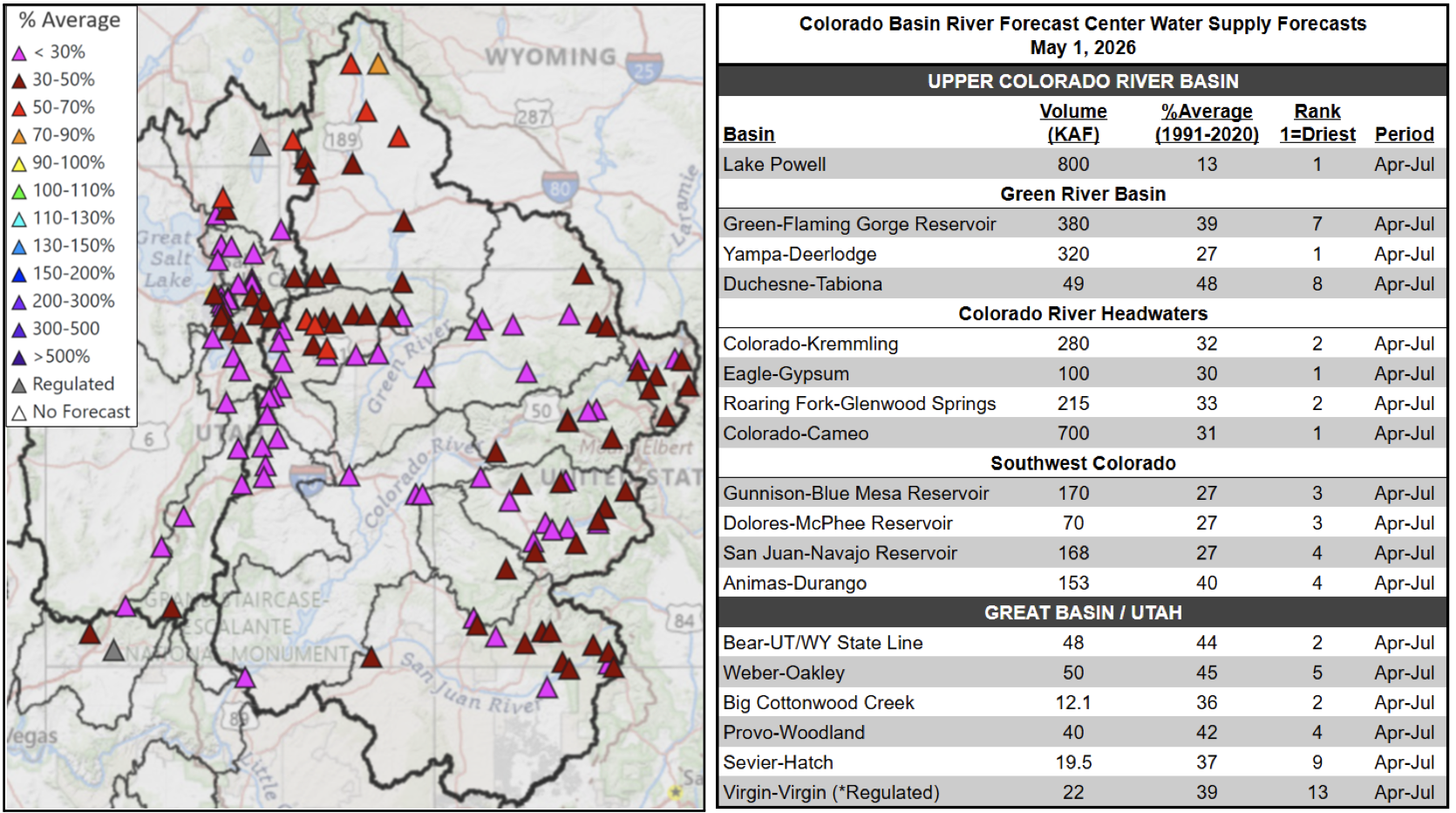
Colorado River Basin Forecast Center Hydrologist Cody Moser was frank on Thursday, May 7, as he gave his final update for the season on conditions across the basin that supplies water for 40 million people. Through a historically hot and dry winter, Moser said the National Oceanic and Atmospheric Administration’s models for how much water will flow through the Colorado River mostly trended in one direction: downward. The latest models now estimate inflows into Lake Powell — the nation’s second largest reservoir — to be just 800,000 acre-feet this year, which would be the lowest since the reservoir began to fill in 1963.
“So really, just no good news,” he said.
Across the West, there is a dearth of snow remaining in the mountains to melt into the Colorado River’s complex system of tributaries and reservoirs. Since the start of the “water year” in October, the Colorado River Basin above Lake Powell has seen just 79% of normal precipitation, according to the forecast center. The Colorado River Headwaters region, which includes much of northwest Colorado, has had among the lowest precipitation, with less than 70% of normal. The snowpack this past winter peaked about a month early and with snow measurement sites across nearly the entire basin showing record-low water content in the snow, Moser said. In the Colorado River Headwaters region, data show snow-water equivalent peaked 7 inches below normal. In March, an “extreme” heatwave sent temperatures surging 20-30 degrees above normal in many parts throughout the Colorado River Basin, rapidly melting much of the remaining snowpack, he said. With so little snow to melt off, streamflow volumes on the Colorado River near Eagle and Cameo are projected to be the worst on record, according to the forecast center. Meanwhile, streamflow volumes near Kremmling and Glenwood Springs are expected to be the second-worst on record. While some parts of the Colorado River Basin saw precipitation in April that was closer to normal or even slightly above normal, Moser said it remained below normal in the Colorado River Headwaters region. He noted, though, these drought-plagued parts of northwestern Colorado did pick up some more significant precipitation in the first week of May.