
Day: February 5, 2014
Secretary Vilsack Announces Regional Hubs to Help Agriculture, Forestry Mitigate the Impacts of a Changing Climate

Here’s the release from the USDA:
‘Climate Hubs’ will provide regional networks on climate science, forecasting impacts as part of President’s Climate Action Plan
Agriculture Secretary Tom Vilsack announced today the creation of the first ever Regional Hubs for Risk Adaptation and Mitigation to Climate Change at seven locations around the country. “Climate Hubs” will address increasing risks such as fires, invasive pests, devastating floods, and crippling droughts on a regional basis, aiming to translate science and research into information to farmers, ranchers, and forest landowners on ways to adapt and adjust their resource management. In his State of the Union Address, President Obama pledged that his Administration will continue to do everything in its power to act on climate change. Today’s announcement is part of the President’s Climate Action Plan to responsibly cut carbon pollution, slow the effects of climate change and put America on track to a cleaner environment.
“For generations, America’s farmers, ranchers and forest landowners have innovated and adapted to challenges. Today, they face a new and more complex threat in the form of a changing and shifting climate, which impacts both our nation’s forests and our farmers’ bottom lines,” said Vilsack. “USDA’s Climate Hubs are part of our broad commitment to developing the next generation of climate solutions, so that our agricultural leaders have the modern technologies and tools they need to adapt and succeed in the face of a changing climate.”
The Secretary first announced his intention to create the Hubs last summer. The Hubs will provide outreach and information to producers on ways to mitigate risks; public education about the risks climate change poses to agriculture, ranchlands and forests; regional climate risk and vulnerability assessments; and centers of climate forecast data and information. They will also link a broad network of partners participating in climate risk adaptation and mitigation, including universities; non-governmental organizations; federal agencies such as the Department of Interior and the National Oceanic and Atmospheric Administration; Native Nations and organizations; state departments of environment and agriculture; research centers; farm groups and more.
Across the country, farmers, ranchers and forest landowners are seeing an increase in risks to their operations due to fires, increases in invasive pests, droughts, and floods. For example, in the Midwest, growing seasons have lengthened by almost two weeks since 1950. The fire season is now 60 days longer than it was 30 years ago, and forests will become increasingly threatened by insect outbreaks, fire, drought and storms over the next 50 years. These events threaten our food supply and are costly for producers and rural economies. Drought alone was estimated to cost the U.S. $50 billion from 2011 to 2013. Such risks have implications not only for agricultural producers, but for all Americans.
The Hubs were chosen through a competitive process among USDA facilities. In addition to the seven Hubs, USDA is designating three Subsidiary Hubs (“Sub Hubs”) that will function within the Southeast, Midwest, and Southwest. The Sub Hubs will support the Hub within their region and focus on a narrow and unique set of issues relative to what will be going on in the rest of the Hub. The Southwest Sub Hub, located in Davis, California, will focus on specialty crops and Southwest forests, the Southeast Sub Hub will address issues important to the Caribbean, and the Midwest Sub Hub will address climate change and Lake State forests.
The following locations have been selected to serve as their region’s center of climate change information and outreach to mitigate risks to the agricultural sector:
Midwest: National Laboratory for Agriculture and the Environment, Agricultural Research Service, Ames, Iowa
Midwest Sub-Hub in Houghton, Mich.
Northeast: Northern Research Station, Forest Service, Durham, N.H.
Southeast: Southern Research Station, Forest Service, Raleigh N.C.
Southeast Sub-Hub in Rio Piedras, Puerto Rico
Northern Plains: National Resources Center, Agricultural Research Service, Fort Collins, Colo. [ed. emphasis mine]
Southern Plains: Grazinglands Research Lab, Agricultural Research Service, El Reno, Okla.
Pacific Northwest: Pacific Northwest Research Station, Forest Service, Corvallis, Ore.
Southwest: Rangeland Management Unit/Jornada Experimental Range, Agricultural Research Service, Las Cruces, N.M.
Southwest Sub-hub in Davis, Calif.“This is the next step in USDA’s decades of work alongside farmers, ranchers and forest landowners to keep up production in the face of challenges,” Vilsack said. “If we are to be effective in managing the risks from a shifting climate, we’ll need to ensure that our managers in the field and our stakeholders have the information they need to succeed. That’s why we’re bringing all of that information together on a regionally-appropriate basis.”
The Climate Hubs will build on the capacity within USDA to deliver science-based knowledge and practical information to farmers, ranchers and forest landowners to support decision-making related to climate change across the country.
For more information, visit http://www.usda.gov/climatechange.
Main breaks 101 – Raising our infrastructure GPA
02-05-14 CMU Water Center News: Water Leaders Seek to Avert Loss of Power Generation from Lake Powell…
The Winter 2014 issue of Headwaters: The Fine (and Fun!) Art of Engaging People Around Water, now available
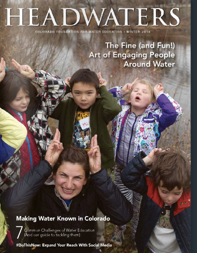
Click here to read the issue. The publication is from the Colorado Foundation for Water Education.
More education coverage here
Snowpack news: What a difference a week makes for southeastern Colorado #COdrought
From The Pueblo Chieftain (Chris Woodka):
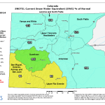
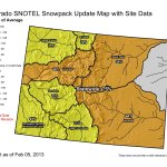
Snow that began overnight Thursday and continued through Tuesday has significantly improved Colorado’s snowpack outlook. Last week at this time, water watchers were looking at the skies trying to determine where this year’s supply would come from. Snowpack charts appeared to be flatlining for a third consecutive year. This week, state snowpack totals in most of the state’s basins improved to above average — an encouraging sign that may not mean much if March and April fail to produce.
The Arkansas River basin is at 114 percent of median, while the Upper Colorado River basin, which provides supplemental water for the Arkansas Valley, is at 121 percent. The Rio Grande basin remains the driest in the state with just 82 percent of average.
Snow data from the Natural Resource Conservation Service Snotel sites shows a foot or more of moisture in the snowpack of many of its sites at higher elevations in both the Arkansas and Colorado basins.
Snow totals since Friday range from 3-9 inches in Pueblo County to about 2 feet in Lake County near Leadville, according to Community Collaborative Rain, Hail & Snow Network weather spotters. Tuesday’s snow even left 2-4 inches east of Pueblo in Otero and Prowers counties.
Ski areas report higher accumulations since the weekend, with 16 inches added to a 100-inch base at Wolf Creek; 6 inches, 82-inch base at Monarch; and 2 inches, 72-inch base at Ski Cooper.
That should translate into more water supply, at least in the short-term. At the end of January, winter water storage was almost 70,000 acre-feet, just 85 percent of average. However, it was 50 percent better than at the same time last year.
From Aspen Public Radio (Marci Krivonen):
The massive winter storm that blanketed our region last week brought more than just smiles to skiers, it delivered needed moisture to the snowpack. Colorado’s mountains store water used for crops, in homes and for recreation so, it’s important to have a good supply. Aspen Public Radio’s Marci Krivonen spoke with the Roaring Fork Conservancy’s Sarah Johnson. (Click through to listen to the interview.)
From The Greeley Tribune:
anuary in Greeley was a wet one. Greeley received 9.7 inches of snow, which is 3.4 inches above normal, and recorded the 11th snowiest January on record, according to numbers provided by the Colorado Climate Center. That snow in January resulted in 1.06 inches of precipitation — 0.58 inches above normal, and making it the fourth-wettest January on record.
From the Sky-Hi Daily News:
The USDA Natural Resources Conservation Service (NRCS) Kremmling Field Office snow surveyors Mark Volt and Noah Bates took the February 1 snow survey measurements during the last days of January. The readings were taken before the Jan. 30-31 snowstorm that dumped 1-2 feet of snow in the mountains.
Snowpack in the high-elevation mountains above Middle Park is now around 120 percent of the 30-year average.
It’s still early in the season but we are doing good. Last year’s snowpack at this time was only 73 percent of average.
Snow density is averaging 24 percent, which means that for a foot of snow there are 2.9 inches of water. Lower depth of the snowpack is very granular, which is responsible for the weak snow stability.
Most of the snow courses around Middle Park have been read since the 1940s. Snow course readings are taken at the end of each month, beginning in January and continuing through April. March is historically the snowiest month, and the April 1 readings are the most critical for predicting runoff and summer water supplies, as most of our high country snowpack peaks around that time.
So far this year snow is driving away drought in much of Colorado.
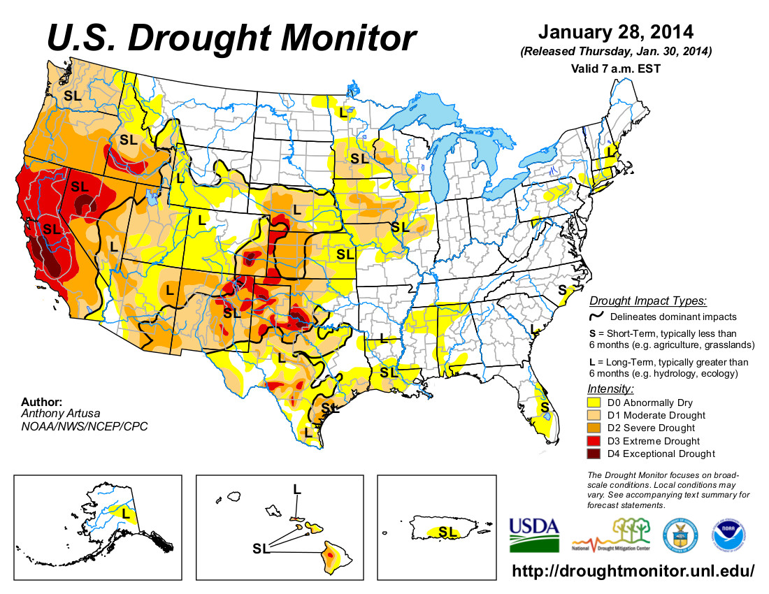
“We have a much more positive outlook going into 2014 than we had last year,” said Colorado Springs Utilities, Water Supply Planning Supervisor, Abby Ortega.The national drought map now shows most of Colorado under “abnormally dry” conditions. It is an upgrade of several levels, from the “extreme drought” designation across most of the state last year.
There is optimism among water managers, but also caution. Snowpack is deeper than the 30 year average, but Ortega points out that this is just the start of the snow season. She says March and April are typically the months when the most significant moisture falls in Colorado. She also says we are still in a water deficit. “We’re certainly optimistic. We’re looking at the snowpack but in addition we need to keep in mind that after the last two years of dry conditions our reservoir storage is well below normal.”
Pueblo: ‘Unlimited growth may be good until you run out of resources’ — Steve Vandiver #COWaterPlan

From The Pueblo Chieftain (Chris Woodka):
Pueblo’s business community has become complacent about water and needs to get involved in the state’s water planning, local business leaders said Tuesday.
“We’re fortunate in Pueblo that we’ve had people watching out for us. It’s time for the business community to step up and run some cover for our water leaders” said Rod Slyhoff, president of the Greater Pueblo Chamber of Commerce.
Slyhoff was among local business leaders and elected officials who attended a water forum Tuesday at the Pueblo Convention Center. The forum was sponsored by two statewide business groups, Accelerate Colorado and the Colorado Competitive Council.
The statewide groups are preparing a list of recommendations to submit to Gov. John Hickenlooper as a statewide water plan moves toward completion.
The forum featured comments on a variety of water-related topics.
There was some disagreement between Slyhoff and Mizraim Cordero, director of the Competitive Council, over a legislative bill that would allow flex water rights. Cordero supported the bill while Slyhoff said it might lead to more farm dry-ups.
James Eklund, director of the Colorado Water Conservation Board, said the water plan is attempting to balance water needs for a statewide population that likely will double in 30 years.
“We don’t have enough water to address all the needs of the state. If people in this state want a say in water, the water plan is the place to do it,” Eklund said.
Terry Book, executive director of the Pueblo Board of Water Works, said the utility’s mission of providing the highest quality water at the lowest possible price includes assisting in community and economic development.
The utility’s economic development efforts have included investing $5 million on incentives to lure industry, he said.
However, the effort also can bring unintended consequences, Book said. Efforts to quickly expand service to the St. Charles Industrial Park for Vestas presented the utility with a new layer of regulations to address, he said.
Jack Rink, president of the Pueblo Economic Development Corp., said the average businessperson looks for guidance on complicated issues such as water from those who regularly deal with the subject.
“Let us know when we can make an impact and you’ll find we can be supportive,” Rink said.
Gary Barber, chairman of the Arkansas Basin Roundtable, explained how his group was able to bring new voices into the planning process. “The real pressure is on agriculture and that forced us to have a dialogue,” Barber said.
Steve Vandiver, general manager of the Rio Grande Water Conservation District, said it’s highly unlikely any more water will be available with conservation alone. He suggested building more reservoirs.
As for another option, slowing down the influx of people coming to the state, “When I’ve said (that) . . . you guys beat me senseless,” Vandiver said. “Unlimited growth may be good until you run out of resources.”
More Colorado Water Plan coverage here.
New Planning and Drought guide from the American Planning Association #COdrought
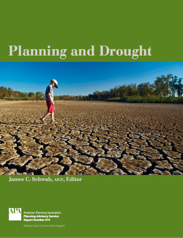
Click here to go to the NIDIS website to download or purchase a copy of the report. From the website:
People can take steps ahead of time to reduce the effects of drought, just as they would for other natural disasters. Planning ahead gives decision-makers, resource managers and citizens the chance to relieve the most suffering at the least expense. Reacting to drought in ‘crisis mode’ is often expensive and not well-targeted.
The National Drought Mitigation Center offers more information about planning ahead in Why Plan for Drought. NDMC also maintains a Drought Management Database, a growing collection of information about what has been tried in responding to and preparing for drought in the U.S.
Will California’s drought become Colorado’s problem? — North Denver News #COdrought #ColoradoRiver
From the North Denver News:
A new report says California’s drought has had major impacts– at mid-winter, water storage in the state is at near decade low-levels. For Colorado, water watchers have been worried about the country’s largest state making new demands on the Colorado River.
Updates to satellite data show that California’s Sacramento and San Joaquin River basins are at near decade-low water storage levels. These and other findings on the State’s dwindling water resources were documented in an advisory report released today from the UC Center for Hydrologic Modeling (UCCHM) at the University of California, Irvine.
Responding to Governor Jerry Brown’s recent declaration of a drought emergency in California, a team of UCCHM researchers has updated its research on the state’s two largest river basins, and the source of most its water. The region also encompasses the Central Valley, the most productive agriculture region in the country. The Central Valley depends entirely on the surface and groundwater resources within the river basins to meet its irrigation needs and to produce food for the nation.
Using satellite data from NASA’s Gravity Recovery and Climate Experiment (GRACE) mission, the researchers, led by UCCHM Director and UC Irvine Professor Jay Famiglietti, found that as of November 2013, total water storage in the river basins — the combination of all of the snow, surface water, soil moisture and groundwater, and an integrated measure of basin-wide water availability — had declined to its lowest point in nearly a decade. GRACE data for the record- dry 2013-2014 winter months were not yet available for analysis.
The data show particularly steep water losses between November 2011 and November 2013, the early phase of the current drought. Famiglietti and fellow UCCHM researchers estimate that the basins have already lost 10 cubic kilometers of fresh water in each of the last two years — equivalent to virtually all of California’s urban and household water use each year. “That’s the steepest decline in total water storage that we’ve seen in California since the GRACE mission was launched in 2002,” Famiglietti said.
The researchers noted that snowpack, surface water and soil moisture storage in the river basins were all at their lowest points in nearly a decade, illustrating a growing threat to groundwater supplies in the Central Valley, and highlighting the urgent need to manage them sustainably. Groundwater is typically viewed as a strategic reserve that supplements sparse surface water supplies in times of drought.
By combining their satellite-based estimates of 10 years (October 2003 – November 2013) of Central Valley groundwater storage changes with long-term estimates of groundwater losses from the U. S. Geological Survey, the researchers noted that steep declines in groundwaterstorage are typical during droughts, when Central Valley farmers are forced to rely more heavily on groundwater to meet irrigation demands.
The advisory report underscores that the rates of declining groundwater storage during drought almost always outstrip rates of groundwater replenishment during wet periods, and raises fears about the impact of long-term groundwater depletion on sustaining a reliable water supply in the current, record-setting drought. The team’s previous 2011 study estimated that the Central Valley lost 20 cubic kilometers of groundwater during the 2006-2010 drought.
Historically, drought conditions and groundwater depletion in the Central Valley are responsible for widespread land subsidence, reductions in planted acreage, higher food costs and ecological damage.
Famiglietti notes that if the drought continues “Central Valley groundwater levels will fall to all- time lows.” Stephanie Castle, a UCCHM researcher who contributed to the report, believes that groundwater supplies should be more actively managed. Castle states that “the path of groundwater use that we are on threatens the sustainability of future water supplies for all Californians.” She noted that several communities within the state are on track to run out of water within the next few months.
From NOAA:
The most populated state in the country is facing what may be its worst drought in a century of record-keeping. On January 20, the governor of California declared a state of emergency, urging everyone to begin conserving water. Water levels in all but a few reservoirs in the state are less than 50% of capacity, mountains are nearly bare of snow except at the highest elevations, and the fire risk is extreme. In Nevada, the situation is much the same.
California has a climate like the Mediterranean region: hot, dry summers and mild, wet winters. More than half of the annual precipitation arrives via winter storms between December and February. For the third winter in a row, precipitation has been below normal across the state. The last week of January is the midway point of the winter wet season, and accumulated precipitation since July is the lowest on record.
The current conditions are the product of several poor wet seasons in succession. The past 30 months—encompassing the past two winter wet seasons and the first half of the current one—are the driest since 1895 for comparable months.
On average, California will accumulate more than 53 inches of precipitation statewide over a typical 30-month span stretching from July to December, based on NOAA Climate Division Data. (Of course, there are huge differences from place to place based on elevation.) In the 30 months preceding December 2013, the state has received closer to 33 inches, just a bit less than the previous record low for a similar period, from July 1975-December 1977.
From the Boston Globe (Adam Nagourney):
The punishing drought that has swept much of the West is confronting authorities with the worst water shortage the region has faced in more than a century, with near-empty reservoirs, parched fields, starving livestock, clouds of smog, and outbreaks of wildfires.
With no sign of significant rain, 17 rural communities in California that provide water to 40,000 people are in danger of running out of water within 60 to 120 days.
California authorities announced Friday that they had no water left in the State Water Project, the main municipal water distribution system, to supplement the dwindling supplies of local agencies that serve 25 million people. It is the first time the project has turned off its spigot in its 54-year history.
“We are on track for having the worst drought in 500 years,” said B. Lynn Ingram, a professor of earth and planetary sciences at the University of California Berkeley…
The deteriorating situation is likely to mean imposition of mandatory water conservation measures for homeowners and businesses, who have already been asked to voluntarily reduce their water use by 20 percent.
The drought, technically in its third year, is forcing big shifts in behavior. Farmers in rural Nevada said they had even given up on planting, while ranchers in Northern California and New Mexico said they were being forced to sell off cattle as fields that should be 4 feet high in grass are blankets of brown and stunted stalks.
“I have experienced a really long career in this area, and my worry meter has never been this high,” said Tim Quinn, executive director of the Association of California Water Agencies, a statewide coalition. “We are talking historical drought conditions, no supplies of water in many parts of the state.
Here’s a release about drought planning in California via Reclmation:
With California in its worst drought in the state’s 160 years of record-keeping—and following Governor Edmund G. Brown Jr.’s declaration of a Drought State of Emergency on January 17—the Departments of the Interior, Agriculture and Commerce are working with the State of California to accelerate water transfers and exchanges, provide operational flexibility to store and convey water, expedite environmental review and compliance actions, and pursue new or fast-track existing projects that might help stretch California’s water supplies.
Federal and State officials met today to discuss a collaborative response to the drought to minimize its social, economic and environmental impacts. Led by Bureau of Reclamation Commissioner Michael L. Connor and California Department of Water Resources Director Mark Cowin, administrators from U.S. Fish and Wildlife Service, National Marine Fisheries Service, Natural Resources Conservation Service (NRCS), National Integrated Drought Information System and the U.S. Army Corps of Engineers joined in a demonstration of support for an “all-in” strategy on ongoing efforts to address drought conditions in California. The agencies are seeking maximum flexibility in carrying out water supply operations, investing in conservation measures and coordinating with the California State Water Resources Control Board to implement any new operational standards.
Today Reclamation and NRCS announced they are working together to leverage Federal funds for water delivery agencies and agricultural producers, and will provide up to $14 million in funding for water districts and associated growers to conserve water and improve water management. The projects funded through this partnership in Fiscal Year 2014 will help communities build resilience to drought, including by modernizing their water infrastructure and efficiently using scarce water resources, while continuing to support the agricultural economy.
“The drought situation is dire throughout the state, and communities, farms, ranches, businesses and the environment are feeling its effects,” stated Connor. “The federal and state governments can provide assistance in a variety of ways, and we are coordinating the federal response to bring resources and assistance to California through the National Drought Resilience Partnership.”
This funding opportunity builds upon an announcement yesterday from Agriculture Secretary Tom Vilsack that funding will be made available through the NRCS for agricultural water conservation efforts throughout California. Affected landowners have until March 3, 2014 to apply for $20 million in available funds.
“The Obama Administration and USDA are doing everything within our power to support those affected by this devastating drought,” said Vilsack. “These funds will support a suite of scientifically-proven conservation techniques that will help California farmers and ranchers maximize every available drop of water while conserving and protecting water resources for future generations.”
On January 27, California’s Natural Resources Agency, EPA and Department of Food and Agriculture released the California Water Action Plan, defining the state’s goals and vision through 2019 with a focus on sustaining water supplies for people, the environment, industry and agriculture. The Governor’s proposed 2014-2015 budget recommends $618.7 million in funding for water efficiency projects, wetland and watershed restoration, groundwater programs, conservation, flood control and integrated water management. Please visit http://resources.ca.gov/california_water_action_plan/ to view the plan.
Director Cowin stated, “The Department of Water Resources welcomes our ongoing, close partnership with the Bureau of Reclamation in managing water supplies for California. It will take our combined efforts to deal with the extraordinary drought conditions we now face. Alongside the Bureau, we plan to manage our limited available water supplies in a way that protects public health and safety, and preserves these supplies should dry conditions persist.”
As called for in President Obama’s Climate Action Plan, the National Drought Resilience Partnership will help coordinate the federal response to drought impacts and work closely with state, regional and local governments. The partnership includes the Departments of the Interior, Agriculture, Energy, and Commerce (NOAA), Assistant Secretary of the Army for Civil Works, Federal Emergency Management Agency and Environmental Protection Agency.
“The federal family recognizes how serious the drought is for California,” said NOAA Acting Administrator Dr. Kathryn Sullivan. “NOAA and our partners are strengthening our real-time drought-related weather and water predictions for all the western states. As conditions on the ground in California change, we’re working to enable rapid adjustments in operations and water transfers in the Central Valley, while also looking to the future to plan for, and mitigate, on-going drought scenarios.”
In addition, today Reclamation released its 2014 Central Valley Project Water Plan, which was developed through a series of meetings that began in mid-2013 with water and power users, environmental interests, tribes, and state and federal agencies. The plan outlines numerous actions to help water users better manage their water supplies during drought conditions, such as expanding operational flexibility and streamlining the water transfer process. The plan is available at http://www.usbr.gov/mp/PA/water where visitors will also find a wide variety of current and historical information on CVP water operations, transfers, deliveries and contracts.
On Friday, January 31, the Bureau of Reclamation announced that, due to the severe drought conditions and with the consent of all settlement parties, it will begin reducing San Joaquin River Restoration Program’s Restoration Flows one month earlier than called for in the settlement, thereby making available about 13,000 acre-feet to the Friant Division long-term contractors with first priority to meet human health and safety needs.
Connor also noted that pumping operations at the federal Jones Pumping Plant, located in the Sacramento-San Joaquin Bay Delta near Tracy, California, have been restricted by the lack of water due to drought conditions and State water quality permit requirements; they have not been curtailed by Endangered Species Act requirements for protection of imperiled fish species.
By continuing to work together and remaining focused on conditions, needs and relief measures, the managers of California’s state and federal water projects remain dedicated to making decisions during this critical time that are right for California’s people and communities, agriculture, businesses, imperiled species, power and the environment.