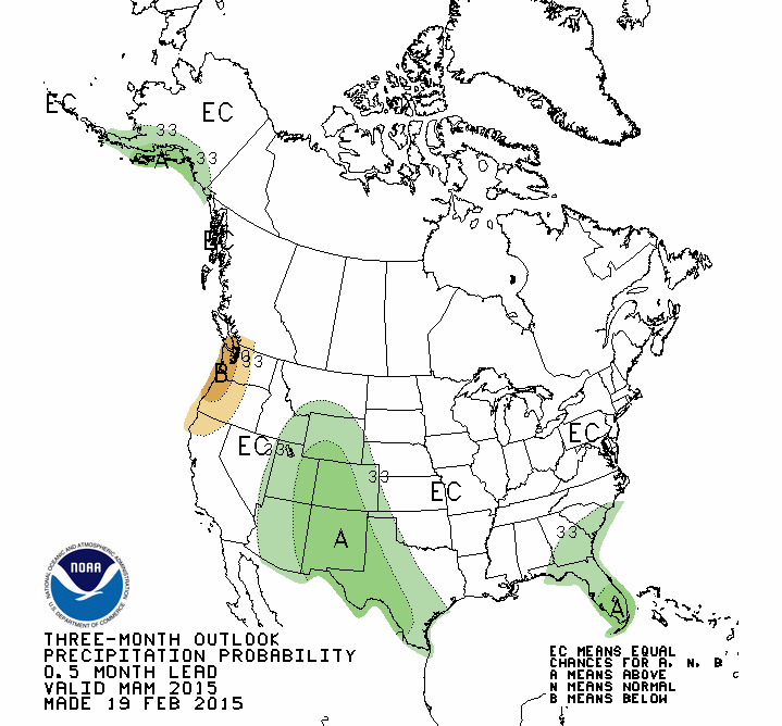
Seasonal Drought Outlook February 19 thru May 31, 2015 via the Climate Prediction CenterThree month precipitation outlook February 19 thru May 31, 2015 via the Climate Prediction CenterTemperature outlook February 19 thru May 31, 2015 via the Climate Prediction Center
Click on a thumbnail above to view a gallery of drought data from the US Drought Monitor. Click here to go to the US Drought Monitor website. Here’s an excerpt:
Summary
The upper-level circulation pattern during this U.S. Drought Monitor (USDM) week consisted of a persistent ridge over the western CONUS (contiguous United States) and trough in the east. The ridge kept temperatures warmer than normal and blocked significant precipitation, while the trough funneled cold and dry air masses across the CONUS east of the Rockies and well into the Caribbean. Weather systems moving in the upper-level flow brought above-normal precipitation to parts of the Rockies and adjacent High Plains and Upper Mississippi Valley. A large weather system at the end of the week brushed the Ohio Valley as it moved out of the Southern Plains and across the Southeast to Mid-Atlantic coast. It brought rain, snow, sleet, and freezing rain to these areas, but precipitation amounts were mostly below normal for the week…
The Plains and Midwest
Portions of the Northern Plains and Upper Midwest received half an inch or less of precipitation this week, but this registered as above-normal due to normal being low during the winter dry season. A handful of stations in Upper Michigan reported more than half an inch of precipitation. Much of the Central Plains to Lower Great Lakes reported little to no precipitation. Precipitation was below normal (half an inch or less) across most of the Great Plains, except portions of Texas and southeast Oklahoma which received an inch or more of precipitation. Although streamflow levels were significantly low, much of Kentucky was buried in 8 to 16 inches of snow this week, with liquid equivalents of an inch or more of precipitation, so no change was made to the depiction over the Bluegrass State. D0-D3 expanded in southwest Texas to the Texas panhandle due to re-evaluation of data…
The West
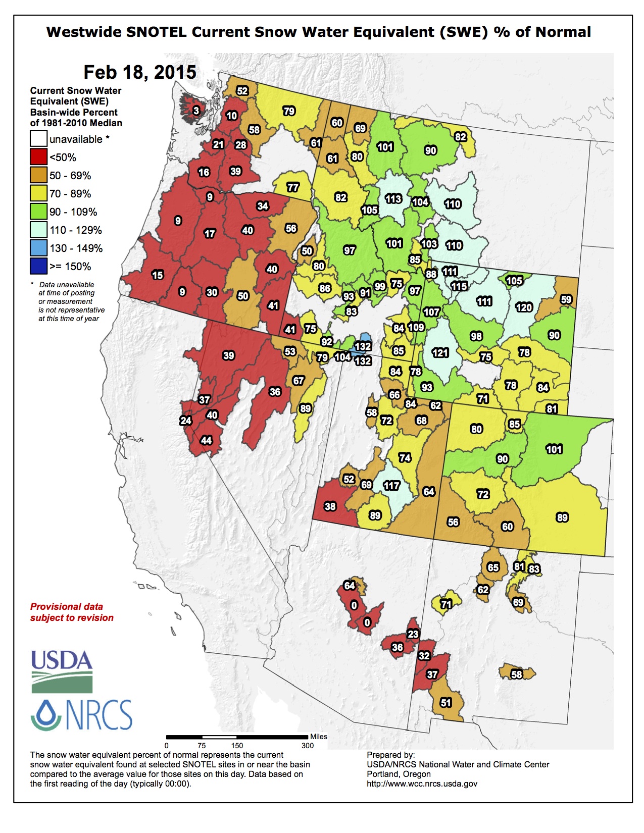
Half an inch to an inch of precipitation was reported in a few parts of the West, mainly northwest Washington and portions of the Rockies. Half an inch or less was received in other parts of the Pacific Northwest and Rockies and southeast Arizona, but most of the West received little to no precipitation this week. While storm systems during December and early February helped replenish some reservoirs, the precipitation fell mostly as rain instead of snow, so the mountain snowpack in the coastal ranges remained dismally below normal, severely impacting the ski industry. According to the National Resource Conservation Service (NRCS) SNOTEL network, mid-February snowpack snow water content ranked in the lowest 5 percent of the historical record at many stations throughout Washington, Oregon, California, and Utah, and, in fact, in most western states. Persistent well-above-normal temperatures continued to melt the snowpack, with snow depth decreasing as much as 4 to 12 inches in the last 7 days at many SNOTEL stations in the Pacific Northwest and Rockies. The University of California estimated statewide forage production decreased during January due to the month’s very dry conditions, and the Almond Board of California reported a decrease in almond shipments of about 28 percent in January 2015 compared to January 2014.
D0 was pulled back in eastern Washington, and D1 pulled back in Washington’s Lower Columbia Basin, to better reflect water-year-to-date precipitation conditions and soil moisture combined with the low snowpack water equivalent. In Idaho, the south central D3 was eliminated, D0-D2 was pulled back in the southwest and southeast areas, and D3 was expanded in the southwest to better reflect impact conditions and a tighter moisture gradient. D1 expanded in western Colorado, northeast Utah, and southwest Wyoming to better reflect low mountain snow water content and above-normal evapotranspiration due to persistently above-normal temperatures. The impact boundary was adjusted in this area to reflect short-term impacts.
In the Southwest, an area of D3 was added to northwest Arizona to reflect long-term (24-36 month) dryness. The D0 donut holes along Arizona’s Mongollon Rim were reduced in size, and the D0 in north central towards central New Mexico was filled in with D1, to reflect the low SNOTEL snowpack and reservoir situation. D4 was expanded in Mono and Inyo Counties in California and Esmeralda County in Nevada to reflect dryness in the short term (last 7 days to 6 months) and long term (last 48-72 months)…
Looking Ahead
The upper-level circulation pattern (of ridge west/trough east) will continue. Above-normal temperatures are expected over the western CONUS and below-normal temperatures east of the Rockies, with weekly temperature anomalies as much as 20 degrees below normal during the next 7 days. Another storm system will develop in the east, bringing an inch or more of precipitation to the Mid-Mississippi and Ohio Valleys and coastal Mid-Atlantic to Northeast. The NWS HPC 7-Day Quantitative Precipitation Forecast (QPF) also calls for half an inch or more of precipitation for February 19-25 across parts of the Rockies and central Plains, eastern portions of the Southern Plains, and most of the country east of the Mississippi River, while half an inch to no precipitation is forecast for the West.
The 6-10 day and 8-14 day outlooks expand the area of below-normal temperatures across the eastern CONUS to the Rockies, while above-normal temperatures should continue along the West Coast to Alaska. Drier-than-normal weather is expected for February 24-March 4 from the northern Plains to western Great Lakes and southwest Alaska, while precipitation should be above normal from parts of the southern Plains, across the Southeast, to the coastal Northeast. Pacific weather systems undercutting the ridge should bring above-normal precipitation to the West late in the period.
Clouds begin to increase [today] in advance of a major weather change on Friday with rain developing by late evening, then quickly changing over to snow. Snow will be heavy early Saturday, decreasing in intensity Saturday afternoon but continuing into Sunday with much colder highs: upper 20s Saturday, low 20s Sunday. By Monday morning there could be up to a foot of snow on the ground in parts of the greater metro area with the temperatures only in the single digits making for a very difficult Monday morning rush hour.
From the Associated Press (Dan Elliott) via The Albuequerque Journal:
Snowpack in the mountain valleys where the Colorado River originates was only a little below normal on Wednesday, marking one of the few bright spots in an increasingly grim drought gripping much of the West.
Measurement stations in western Colorado showed the snowpack at 90 percent of the long-term average.
By contrast, reporting stations in the Sierra Nevada range in drought-stricken California showed snowpack at 50 percent or less in early February, the most recent figures available. Some detected no snow at all.
Mountain snow in Colorado is closely monitored because a half-dozen Western waterways, including the 1,400-mile Colorado River, start in the area. The river and its tributaries supply water to millions of people in seven states and Mexico.
Much of the river comes from mountain snow that accumulates during winter and melts in the spring…
In the Pacific Northwest, warm temperatures have brought rain instead of snow, so the mountains aren’t accumulating snowpack for the spring runoff, when farmers and water managers need water to irrigate crops and refill reservoirs.
Snow accumulation in the Rocky Mountains in Colorado, Wyoming and Montana has been relatively good. Snowpack in the Colorado valleys that feed the east-flowing South Platte River were at 102 percent of average.
“Not spectacular, but not miserable, either,” Strobel said.
Even in Colorado, the picture is mixed. Statewide, including the Colorado River, the South Platte and six other basins, the snowpack stands at 78 percent of normal, with the parched southwest corner at 56 percent.
It would take half again the normal amount of snowfall between now and April to bring the statewide snowpack up to average, said Brian Domonkos, who supervises the snow survey in Colorado.
The Colorado River Basin isn’t accumulating snow as quickly as it was earlier in the season, Domonkos said Wednesday at a meeting of the state Water Availability Task Force, which monitors drought conditions.
“It’s been pretty dry since about the beginning of February,” he said.
The Colorado update came after calls for increased multi-state cooperation in the Colorado River basin due to the prolonged drought. The basin is home to 40 million people and 4 million acres of farmland.
Lake Mead in Nevada is the key measuring point of water in the Colorado River system, which also includes the Green, San Juan and Gila rivers and some 55 dams and diversions. The lake dropped to historic levels last year after almost 15 years of regional drought.
Las Vegas, with 2 million residents and 40 million visitors a year, gets 90 percent of its drinking water from Lake Mead. The U.S. Agriculture Department has declared most of Nevada a natural disaster area due to the drought.
A dry spell starting in late December and carrying through January has compromised Colorado’s snowpack and diminished a once promising water supply outlook, according to the Natural Resources Conservation Service.
SNOTEL data indicates this past January was the driest on record in 28 years in the Colorado mountains.
Overall, January brought just 1.4 inches of mountain precipitation, 45 percent of the average. January typically brings an average of 3.1 inches of mountain precipitation, ranking the month as the fourth most important for precipitation in the year.
The South Platte had the greatest precipitation totals statewide, reaching 62 percent of average.
“With nearly one third of the winter gone, Colorado is running short of time to catch up,” said Brian Domonkos, Colorado Snow Survey supervisor, in a press release. “Statewide, snowfall would need to amount to 124 percent of normal snowfall from now ‘til mid-April to achieve normal snowpack peak levels.”
There are few silver linings with a snowpack as poor as the one now sitting at the headwaters of the Rio Grande River.
But Division Engineer Craig Cotten said recent warm temperatures in the San Luis Valley have not prompted much runoff from the basin’s high country, where snowpack was at 65 percent of average at the beginning of the month.
“We’re still pretty steady, about where we usually are,” he said.
Still, the existing snowpack does not bode well for irrigators come springtime.
The Natural Resources Conservation Service has forecast a flow of 457,000 acre-feet on the Rio Grande, which is 70 percent of average.
The forecast for the Conejos River is about 210,000 acre-feet, which would be about 60 percent of average.
“So, not great at this point,” Cotten said.
The Conejos and the Rio Grande are the two rivers in the valley with obligations to send water downstream to satisfy an interstate compact with New Mexico and Texas.
If the projections hold, the Rio Grande would be required to send 110,000 acre-feet downstream, while the Conejos would be obligated to send 51,000 acre-feet.
But the warm weather has prompted several requests to move up the irrigation season from its typical beginning in April.
Cotten said February is too early to consider such requests but they’ll get a closer look in March.
As the water year progresses, Cotten’s office also will begin using a new stream forecasting service from the National Weather Service.
The information from the weather service would predict flows on the Rio Grande, Conejos, San Antonio and Los Pinos rivers, the latter two of which are tributaries of the Conejos.
Last year, water officials from around the valley said inaccuracies with the NRCS’ snowpack measurement and forecasting services made it difficult to meet the requirements of irrigators while also sending the required amount of water downstream to satisfy the compact.
The weather service’s forecast will provide multiple scenarios and be used in conjunction with the one normally issued by the NRCS.
“Hopefully, they’ll be very close and fairly similar,” he said. “If not we’ll have to have some discussion and see what’s going on.”
This winter’s snow pack in the Colorado Rockies is slightly below average, a relatively good sign for states, including Arizona, that use Colorado River Water.
Measurements taken in the mountain valleys of western Colorado, where the Colorado River originates, put snow pack at 90 percent of the long-term average. Officials from the U.S. Department of Agriculture, which runs the snow survey, said that’s not spectacular – but not miserable either.
Mountain snow in Colorado is closely tracked because when it melts it feeds the Colorado River, which provides water to seven states, including Arizona.
Snow pack in other parts of the West is not looking as good as in Colorado.
The last measurement taken in the Sierra Nevada range put snow pack at 50 percent or less. There was no snow at all at several measurement stations.
And in the Pacific Northwest, warm temperatures have brought rain instead of snow, which means there won’t be much water to refill reservoirs with come spring.
Other than Colorado, not spectacular but not miserable levels of snow pack have been measured in Montana and Wyoming as well.
Don Brown of Yuma is just one vote away from becoming Colorado’s newest Commissioner of Agriculture.
Brown won unanimous confirmation from the Senate Agriculture, Natural Resource and Energy Committee on February 12. He was joined by his mother, wife, three children and two grandchildren.
Former Commissioner Don Ament of Iliff also stood with Brown during the hearing, as did outgoing Commissioner John Salazar.
With Sonnenberg as its chair, shenanigans in the ag committee were to be expected, and the committee did not disappoint. They played a practical joke on Brown and the governor’s staff by voting 5-4 to turn down the nomination. Sen. Lucia Guzman, D-Denver, said she couldn’t vote for a member of the United Methodist Church (Guzman is a United Methodist minister), and other committee members came up silly reasons to reject the nomination. Said Sen. Mary Hodge, D-Brighton, “I grew up in Yuma. I’m sorry, no.” And Sonnenberg wrapped it up. “I guess I don’t have the control and power I thought I had,” which led the committee to then solicit nominations for ag commissioner from the audience.
After a good laugh by all, the committee voted unanimously to send Brown’s nomination to the full Senate for confirmation, with hearty congratulations and warm welcomes to Brown and his family…
Sonnenberg had a pretty good day on February 12 with his committee. In addition to marshaling Brown’s nomination, he got approval for two bills that have been on his radar for several years.
Senate Bill 15-064 would prohibit the US Forest Service and federal Bureau of Land Management from attempting to supersede Colorado water law by putting conditions on special permits that include water rights.
The issue dates back to late 2011, when the US Forest Service issued a directive to require water rights from those who lease federal lands for ski operations or grazing. The Forest Service claimed they wanted the rights to protect them should a ski area decide to sell them, although that has never happened in Colorado. In 2012, a federal judge ruled against the Forest Service, not on the merits of the case, but because the agency failed to follow its own rules. The Forest Service withdrew the directive.
Last year, the Forest Service issued three directives on water rights, including a new one on the ski area water rights that bears little difference from the 2011 directive. Kristen Moseley, a water rights attorney representing the Colorado Water Congress and several Colorado water authorities, told the ag committee Thursday that the Forest Service directives imply that the Forest Service owns water rights by virtue of owning the land. These water rights have already been adjudicated, Moseley said. SB 64 will protect Colorado water rights, she said.
James Eklund, director of the Colorado Water Conservation Board (CWCB), also testified in support of SB 64. The CWCB is an agency of the Colorado Department of Natural Resources.
Several environmental groups testified in opposition to SB 64, including the Audubon Society and Western Resource Advocates (WRA). Jen Bolton of the Audubon Society said the bill conflicts with federal law, and attorney Rob Harris of WRA testified that the bill was overly broad and that the proper place for resolving the issue is through a negotiated settlement rather than state law.
The bill passed on an 8-1 vote and goes to the full Senate for further consideration.
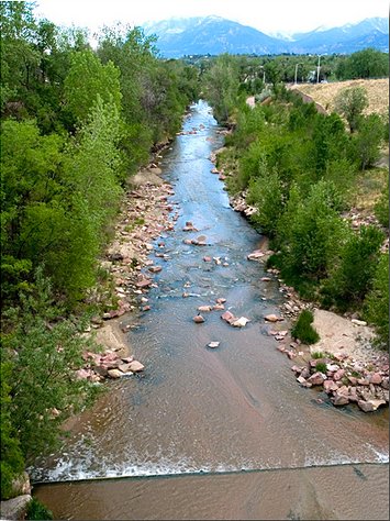
Fountain Creek through Colorado Springs. FromThe Pueblo Chieftain (Chris Woodka):
Pleas to reconsider a federal lawsuit over water quality fell on skeptical ears Wednesday.
The Lower Arkansas Valley Water Conservancy District board listened patiently to Colorado Springs Councilman Merv Bennett’s assessment of stormwater protection progress, but in the end voted to continue to pursue a federal court filing charging that Colorado Springs is violating the Clean Water Act.
The board instructed attorney Peter Nichols to continue building a case.
Bennett urged the Lower Ark board to stay out of court, saying money would be better spent elsewhere. Still the board voted 7-0 to continue the lawsuit.
“Nothing’s binding on this council, the next council or the next mayor,” board member Melissa Esquibel said, clearly frustrated by Bennett’s promises. “It’s the same conversation, the same lack of movement that we’ve had. What’s going to happen?”
Colorado Springs City Council last month commit ted $19 million annually to stormwater projects, shuffling existing funds in the city’s general fund and adding $3 million from Colorado Springs Utilities beginning in 2016.
But Jay Winner, general manager of the Lower Ark, asked Bennett if other funds in the city would be shorted in the process and political pressure would again lower stormwater as a priority.
Bennett countered that the current council is committed to funding stormwater control, as well as the candidates for mayor in the April municipal election. He said the city’s other problems, such as potholes, would be settled in some other way not related to stormwater. He maintained the city currently is spending the required amount on stormwater and council’s action makes the funding permanent.
“I believe in the integrity of the people running,” Bennett said in response to Esquibel’s comments. “I feel we’ve made progress and we’ll continue to make progress.”
But he acknowledged that three to five new members may be elected to the nine-member council, and he could not personally guarantee that the stormwater money would remain in place.
“I can’t solve it by myself and we can’t solve it overnight,” Bennett said.
Winner pressed Bennett on several issues, including the council’s 2009 decision to dissolve its stormwater enterprise, stormwater funding that has been missing in the intervening years and whether the money would go toward projects identified when the enterprise was formed in 2005.
Bennett agreed that council made the wrong decision in response to Doug Bruce’s Issue 300 in 2009. He said Colorado Springs is working on a report that would show its funding level for stormwater projects has been higher than the $17 million the stormwater enterprise would have generated each year.
He pledged to have city staff develop a side-by-side comparison of projects.
The stormwater issue is tied to Pueblo County’s 1041 permit for Southern Delivery System, which was negotiated earlier in 2009, before the stormwater enterprise was abolished. Flood control is needed because growth in Colorado Springs has elevated flows on Fountain Creek, increasing the danger of flooding in Pueblo.