Most of us learned as children that the age of a tree could be found by counting its rings. Rings of trees growing in temperate climates can indeed tell their age through their annual rings and also help determine the age of wood used to construct buildings or wooden objects. The ages of wooden objects can be revealed by cross-dating, the process of matching ring patterns between wood samples of known and unknown ages.
Concentric rings of various widths mark the annual growth of trees. Photo by Peter Brown, Rocky Mountain Tree-Ring Research. Photo credit: NOAA
What do tree rings tell us
The underlying patterns of wide or narrow rings record the year-to-year fluctuations in the growth of trees. The patterns, therefore, often contain a weather history at the location the tree grew, in addition to its age. In dry environments, such as the Middle East or U.S. Southwest, tree rings typically record wet or dry years, and in cooler areas (high latitudes or high elevation), the ring widths are often a proxy for temperature.
Archeologists have used the ring patterns in building timbers to estimate construction dates for some of the world’s most famous buildings, including the cliff dwellings at Mesa Verde National Park (nearly 1,000 years old) and the Church of the Nativity in Bethlehem (nearly 1,500 years old).
The Cliff Palace ruins at Mesa Verde were built in the 1200s by the Ancestral Pueblo people, but were abandoned in the late part of the century. Photo by Ken Lund, used under a Creative Commons license.
What’s in NOAA’s tree ring data base?
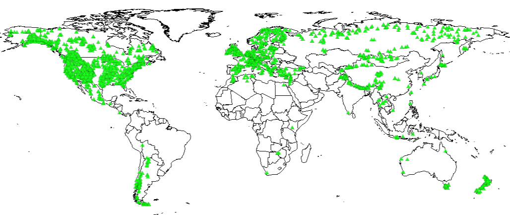
NOAA National Centers for Environmental Information (NCEI) houses the International Tree-Ring Data Bank (ITRDB), which contains ring width data from forests worldwide, plus ring width data from old buildings, and even from rare Stradivari violins. The ITRDB contains ring width data from trees at over 4,600 locations on six continents, providing tree growth histories from around the world. New additions from field scientists are added regularly.
Climate scientists compare the tree growth records to local weather records. For locations where a good statistical match exists between tree growth and temperature or precipitation during the period of overlap, the ring widths can be used to estimate past temperature or precipitation over the lifetime of the tree.
In many parts of the world, trees can provide a climate history for hundreds of years, with some extending back 1,000 years or more. The resulting climate histories enhance our knowledge of natural climate variability and also create a baseline against which human-induced climate change can be evaluated. NCEI archives these climate reconstructions in addition to the tree ring measurements.
Glimpsing the past
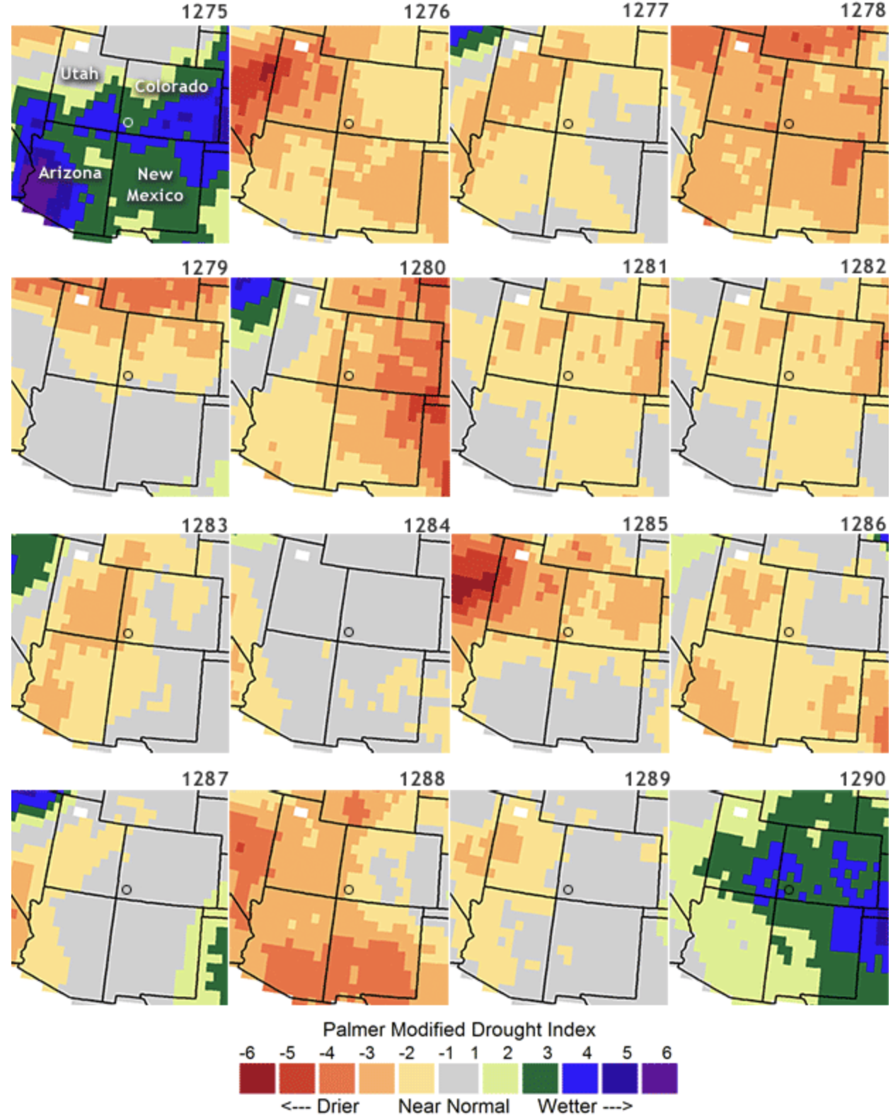
Tree ring data have been used to reconstruct drought or temperature in North America and Europe over the past 2,000 years. For example, tree ring based drought reconstructions for the American Southwest indicate a period of prolonged drought in the late 1200’s. Archeologists believe that the drought was a contributing factor in the Ancestral Pueblo People abandoning the famous cliff dwellings at Mesa Verde, never to return.
Severe drought in the U.S. Southwest in the late 1200s likely contributed to the abandonment of Mesa Verde (marked with open circle) by the Ancestral Pueblo people. Drought maps for the years 1275-1290 reconstructed from tree ring records show that over the 16-year span from 1275-1290, only two wet years occurred. Graphic by Climate.gov, based on summer drought reconstructions from the Living Blended Drought Atlas, courtesy of NOAA and Cook et al., 2010, Journal of Quaternary Science, 25(1), 48-61. doi: 10.1002/jqs.1303.
Changes in the northeastern reaches of Lake Powell are documented in this series of natural-color images taken by the Landsat series of satellites between 1999 and 2017. The Colorado River flows in from the east around Mile Crag Bend and is swallowed by the lake. At the west end of Narrow Canyon, the Dirty Devil River joins the lake from the north. (At normal water levels, both rivers are essentially part of the reservoir.) At the beginning of the series in 1999, water levels in Lake Powell were relatively high, and the water was a clear, dark blue. The sediment-filled Colorado River appeared green-brown. To see the complete series go to: earthobservatory.nasa.gov/WorldOfChange/LakePowell. Photos via NASA
Click here to read the newsletter. Here’s an excerpt:
DROUGHT PLAN SEEMS CLOSER
A Colorado River Drought Contingency Plan to keep water levels in Lakes Mead and Powell from crashing has inched towards completion, as state agencies and key interest groups have endorsed the draft plan over the past month. Endorsing organizations include Nevada water agencies (as reported by the Las-Vegas Review Journal), the Colorado Water Conservation Board and the Colorado River District (despite some reservations, as reported by Aspen Journalism and the Grand Junction Sentinel). Arizona, typically seen as the lone potential hold-out among the states that share the river, has recently made major steps towards an agreement, according to the Arizona Republic. Earlier, the Desert Sun reported that a conflict in a California irrigation district could still complicate adoption of the agreement.
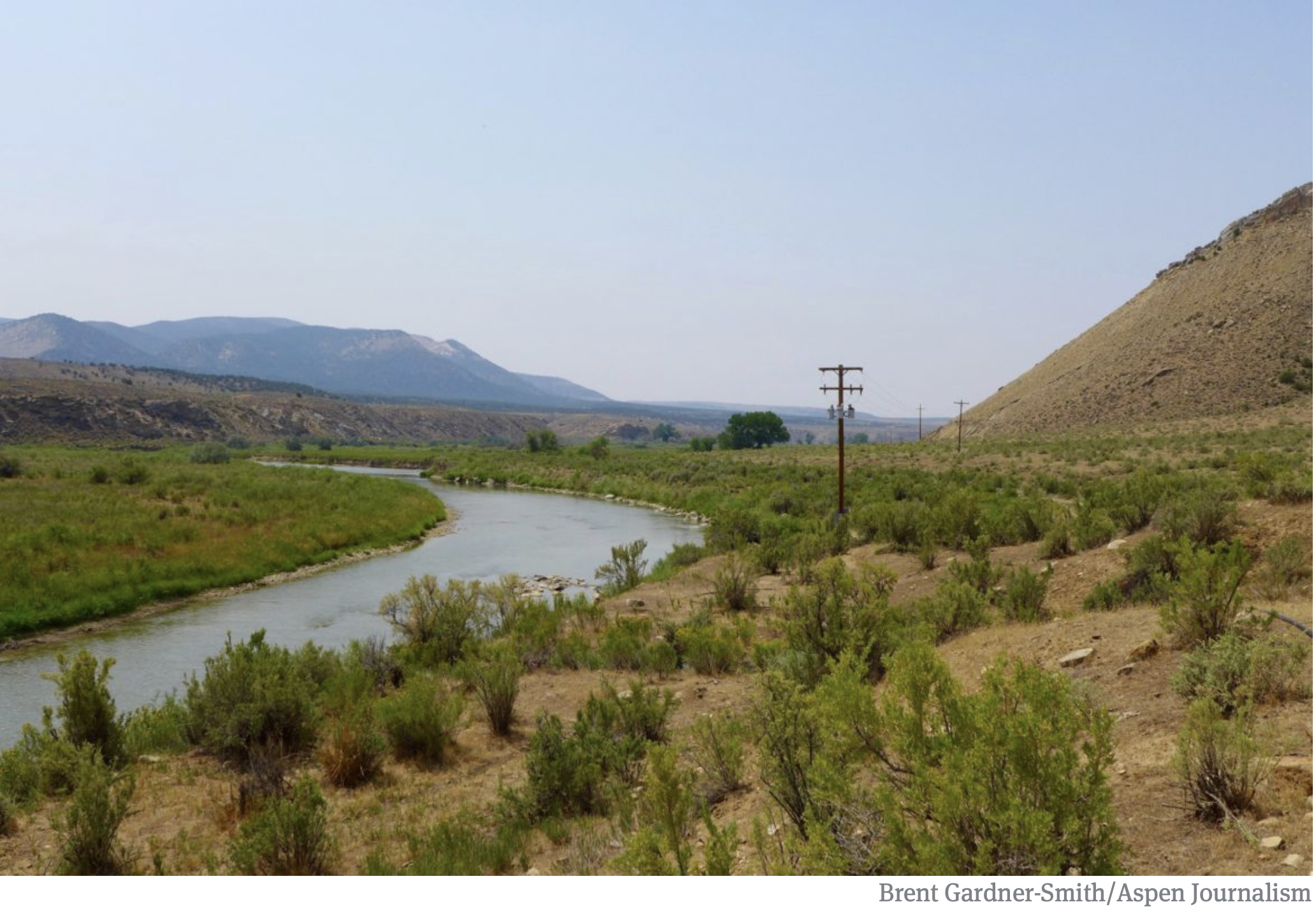
A view of the White River foreground, and the Wolf Creek gulch, across the river. The Rio Blanco Water Conservancy District has been using state funds, and their own, to study two dam options for this area between Meeker and Rangely on the White River. Photo credit: Aspen Journalism/Brent Gardner-Smith
The Colorado Water Conservation Board has given $843,338 to the Rio Blanco Water Conservancy District since 2013 to study a potential dam on the White River, yet officials at the Colorado Division of Water Resources say the project appears “speculative” and Rio Blanco lacks evidence for its claims for municipal, irrigation, energy and environmental uses.
On Nov. 14, the CWCB directors approved the most recent grant application from Rio Blanco for $350,000 to keep studying the proposed White River dam and reservoir project near Rangely.
But while the CWCB is spending more state money to help prepare the White River project for federal approval, another state agency, the Division of Water Resources, is asking hard questions about the project in water court.
“There are concerns whether the district can show that it can and will put the requested water rights to beneficial use within a reasonable period of time and that the requested water rights are not speculative,” wrote Erin Light, the division engineer in Division 6, who oversees the White and Yampa river basins, and Tracy Kosloff, the assistant state engineer in Denver, in a report filed in water court Oct. 4.
In addition to pursuing a series of grants from CWCB, Rio Blanco applied in water court in 2014 for a new water right to store 90,000 acre-feet of water from the White River.
The two engineers in the Division of Water Resources filed their report after consulting with the state attorney general’s office. Review of water rights applications by division engineers is routine, but the report filed by the division engineer and assistant state engineer raised a higher level of concerns than normal.
Also known as the Wolf Creek project, it could store anywhere from 44,000 to 2.92 million acre-feet of water, according to the array of proposals, presentations and applications that have been made public over the project’s ongoing evolution. (Please see: Timeline: tracking the proposed White River dam and reservoir).
The water would be stored either in a reservoir formed by a dam across the main stem of the White River, or in an off-channel reservoir at the bottom of the Wolf Creek gulch.
The latest grant from the CWCB to Rio Blanco was to “finalize the preferred reservoir size and firm-up financial commitments of key project partners so that applications for federal permits can be filed,” according to a CWCB staff memo on the grant.
Asked about the apparent conflict between CWCB and DWR on the White River project, CWCB Director Becky Mitchell said she was aware of the concerns voiced by the division and state engineers and was confident that the next phase of study supported by CWCB would help answer some of the questions raised.
“All of the grants given to Rio Blanco thus far have been all about feasibility, so we are not necessarily in disagreement with DWR, but it needs to trued up,” Mitchell said Tuesday. “There may be concerns with what DWR is stating and the grant will help us evaluate those concerns.”
In another sign of CWCB’s support for the potential project, the agency’s finance section has added a potential $100 million loan to Rio Blanco on a list of potential loans it compiles and publishes as part of the CWCB director’s reports to the agency’s directors.
Brad McCloud of EIS Solutions in Grand Junction is serving as Rio Blanco’s project manager for the White River project.
When asked Tuesday about the contradictory messages sent by the two state agencies, McCloud said, “I think one side is working on one end and the other is doing the other and it’s a good check and balance and the way the system is supposed to work. And there are probably things that will get worked out along the way.”
A view looking downstream of the White River in the approximate location of the potential White River dam and reservoir. The right edge of the dam, looking downstream, would be against the brown hillside to the right of the photo. Photo credit: Aspen Journalism/Brent Gardner-Smith
State questions
In their report filed in water court, the state’s water engineers challenge Rio Blanco oft-stated claim it is seeking the new storage facility at Wolf Creek in order to meet the future water needs of the Town of Rangely, which today takes its water directly from the White River.
“While every case is different and may require evidence tailored to the particular facts of the case, the engineers have not received sufficient evidence to support the district’s claimed water demands for Rangely nor evidence that Rangely intends to rely on water storage in one of the Wolf Creek Reservoirs to meet its demand,” the report from Kosloff and Light says.
The engineers’ report also questions the demand for water in the potential new reservoir from the energy sector.
They said Rio Blanco should, at a minimum, show how much of the 45,800 acre-feet of industrial demand it is claiming is located within the district’s boundaries.
They also say Rio Blanco should make public how much of the demand from the energy sector within the district’s boundaries can be satisfied by the existing water rights of the district.
In addition to challenging Rio Blanco’s claims for municipal and industrial use of water in their 2018 report, Light and Kosloff also question Rio Blanco’s claims for irrigation and environmental uses.
They said a storage report prepared for the project “notes that irrigated acreage and irrigation water demand is projected to decrease in the future” in the area downstream of the reservoir.
And the engineers said they “do not believe that a water right for irrigation use should be awarded in this case.”
And the engineers question Rio Blanco claim that it will release up to 42,000 acre-feet of water from its proposed reservoir to the benefit of endangered fish downstream on the White and Green rivers.
They say an ongoing study has yet to make clear how much water is needed for the endangered fish.
“Long story short, it is still unclear what flows should be used when determining if or how much water needs to be stored to assist with meeting the recommended flows,” the report says. “Until these numbers are known, claiming any quantity of water for these uses is speculative.”
Consultants for the Rio Blanco Water Conservancy presenting a slide earlier this year showing how a dam could be built across the main stem of the White River between Rangely and Meeker. A report from engineers at the Division of Water Resources is questioning the claims made in a water court case in which Rio Blanco is seeking new water rights for the project.
Size in flux
The White River project has a wide range of potential uses, according to Rio Blanco, and it also has a wide range of potential sizes, as various presentations and applications have included potential sizes from 44,000 acre-feet to 90,000 acre-feet to 400,000 acre-feet to 2.92 million acre-feet.
Alden Vanden Brink, the manager of the Rio Blanco district, told the CWCB directors Nov. 14 that his district is not seeking to build a 400,000 acre-foot reservoir, despite the reference in Rio Blanco’s grant application to study a reservoir between 44,000 acre-feet and 400,000 acre-feet.
“The 400,000 is maximum size,” Vanden Brink said. “That is not what the Rio Blanco Water Conservancy District is looking to build. It’s going to take somebody from a way outside source to come to the table for that.”
Vanden Brink said the district was seeking to store “anywhere from 44,000 to about 130,000” acre-feet of water.
However, the grant application from Rio Blanco notes that a 400,000 acre-foot reservoir might have some benefit to the state.
“If the higher end of the storage is implemented, the project has tremendous potential to help the majority of the state of Colorado address Colorado River Compact administration issues,” the grant said.
An earlier study on the dam by W.W. Wheeler and Associates for the Rio Blanco district found it was possible to build a dam on the White River at Wolf Creek that would hold 2.92 million acre-feet of water.
The latest grant application to CWCB from the Rio Blanco district says “the preferred reservoir size will be developed based on the amount of water needed and committed to by key project stakeholders.”
Wade Cox, the president of the Rio Blanco Water Conservancy District, discussed the project in October with the board of the Colorado River District, and referenced the varying potential sizes of the reservoir.
“There is never going to be enough water,” Cox said. “I don’t care how big you build it. Whatever you do, it’s never going to be enough. Somebody somewhere is going to utilize it.”
Editor’s note: Aspen Journalism covers water and rivers in collaboration with The Aspen Times and other Swift Communications newspapers. The Times published the story on Thursday, Nov. 29, 2018.