Click on a thumbnail graphic below to view a gallery of drought data from the US Drought Monitor.
This Week’s Drought Summary
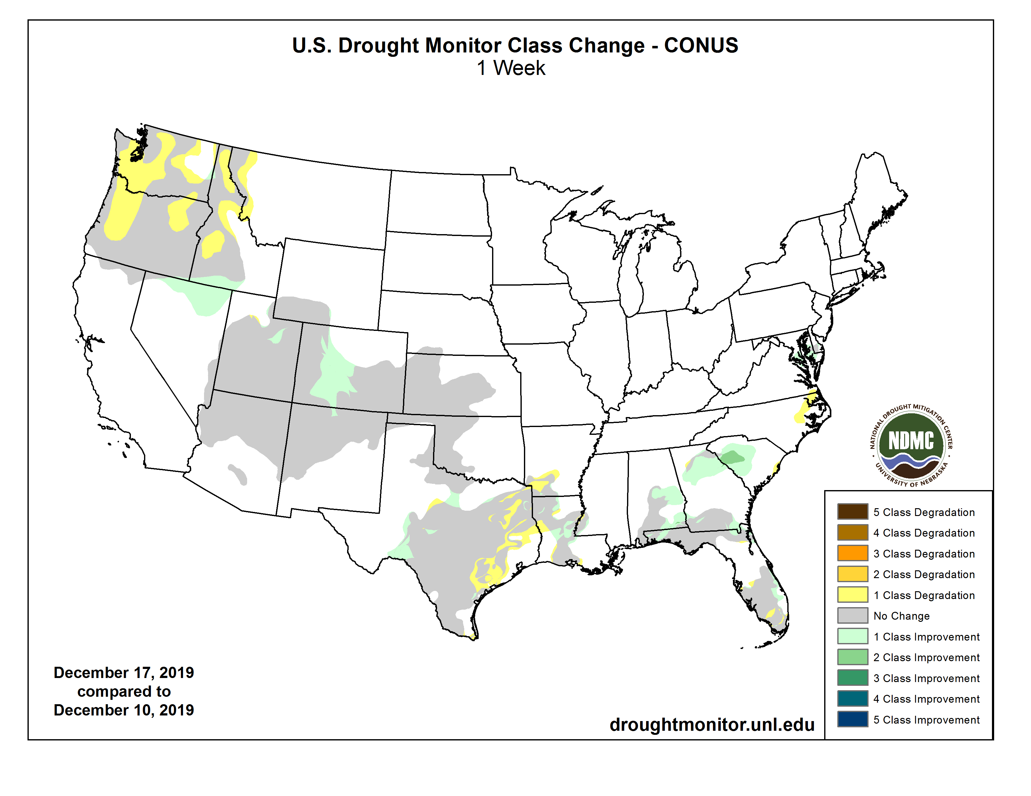
A series of Pacific fronts brought welcome moisture to the Northwest (from northern California northward into Washington), but even with this precipitation, the Water Year to Date (WYTD; since Oct. 1) basin average precipitation and Snow Water Content (SWC) were still well below normal (30-70%). Farther east, frigid Arctic air (weekly average temperatures up to 15 degree F below normal) was bottled up in the northern Plains and upper Midwest (and central Canada), while the West, South, and East observed above-normal readings (weekly temperature anomalies + 3 to 6 degree F). As the fronts progressed eastward, they slowed and waves of low pressure developed along the fronts, generating widespread rains (1-4 inches, locally to 8 inches) in the Southeast, mid-Atlantic, and along coastal New England. In the colder air to the north, the precipitation fell as snow, blanketing parts of the lower Missouri and Ohio Valleys, northern Appalachians, eastern Great Lakes region, and interior New England with light to moderate totals (2-6 inches). In contrast, the Southwest, Plains, and western Corn Belt were mainly dry. In Alaska, above-normal temperatures prevailed across the state, with decent precipitation observed along the southern coast. Shower activity increased across the eastern Hawaiian Islands, allowing for some improvements on the Big Island…
High Plains
Most of the Plains saw little or no precipitation this week, with some light snow falling across North Dakota, southeast Wyoming, Nebraska, and eastern Kansas (for Colorado, refer to the West). The frigid Arctic air was mostly confined to the northern Plains and upper Midwest (weekly TANs -5 to -10 degrees F), although some colder air spilled southward and eastward into the central Plains and Midwest. With this time of the year being climatologically dry, typically cold with little or no evaporation, and with frozen soils, it is a difficult time for drought to develop and expand in most northern areas. Plus, all short- to long-term indices are near to above normal (wet) in the northern Plains. Farther south, however, much drier conditions existed in southwestern Kansas (D2 to D3), especially during the 3- to 6-month range. After 1 to 2 category deteriorations were made the past 4 weeks, no changes were made here this week…
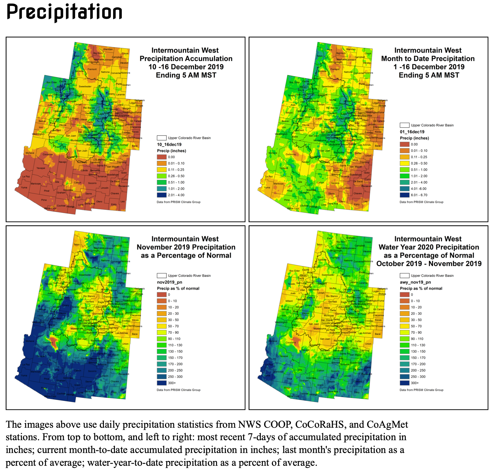
West
After several wet weeks in the Southwest (and much improvement), tranquil weather returned to most of the region. With SNOTEL WYTD basin average precipitation and SWE values in the Southwest generally at or above normal, this region was generally left unchanged. The exceptions to this was across northern Nevada and southern Idaho where light to moderate precipitation (0.5-2 inches) fell, producing positive SPIs (wet) at 1-, 2-, 3-,4-, 6-months, and beyond, along with above-normal USGS stream flows. As a result, D0 was removed in these 2 areas. In northern Utah and most of Colorado, light to moderate precipitation continued to provide drought relief, especially in the central and southern Rockies where a 1-category improvement was made in central Colorado and extreme northern New Mexico. The area of northern Utah was already drought-free.
In contrast, the Northwest (from northern California northward into Washington) finally received welcome and widespread precipitation (2-4 inches along the coast and in the Cascades and Sierra Nevada, locally to 10 inches in extreme northwestern California), but this Water Year has seen far too few weeks like this. This situation is further exacerbated by the fact that this is the wet season (large normal totals) so that even light precipitation can quickly accumulate huge deficits. Thus, even with this week’s precipitation, many stations SPIs at 30-, 60-, 90-days, and longer time periods were at D2-D4 levels; USGS 1-, 7-, 14-, and 28-day average stream flows were at near- or record lows (tenth percentile or less); 90-day deficits exceeded a foot (and more) in western Washington and Oregon; SNOTEL basin average WYTD precipitation ranged between 34-60% and Dec. 18 SWC was between 27-65%. Accordingly, D1 was introduced to the Washington and Oregon Cascades, northeastern Oregon, and northern and southwestern Idaho where the driest tools converged. In addition, D0 was expanded into central Washington, central Idaho, and western Montana…
South
While western sections were dry (Oklahoma, western two-thirds of Texas, western Arkansas), precipitation gradually increased across eastern sections, with scattered lines of showers and thunderstorms dropping light to moderate totals (1 to 3 inches) on parts of Louisiana, Mississippi, and Tennessee. The rains were enough to provide some slight improvement in northern and central Louisiana (D0 and D1 shrunken), but much lighter amounts in southwestern Arkansas and eastern Texas, along with slightly above-normal temperatures, somewhat increased the area of D0-D2 in those 2 areas. In western Oklahoma, conditions were maintained as November and December precipitation is normally quite low this time of year (each month contributes to 1-2% of the annual total), and seasonable temperatures helped…
Looking Ahead
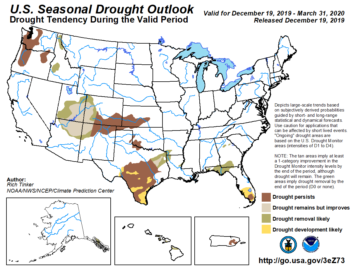
During the next 5 days (December 19-23), most of the lower 48 States will be tranquil (dry), except for heavy precipitation (more than 4 inches) in the Pacific Northwest (from northern California northward), and in the southeastern quarter of the Nation (2-5 inches in the central and eastern Gulf and southern Atlantic Coasts). If this rain occurs, parts of Florida may close in or break their record high December amount, effectively wiping away any existing drought. The upper and eastern Great Lakes region should see snow showers along favored locations. 5-day temperatures should average above-normal for much of the contiguous U.S.
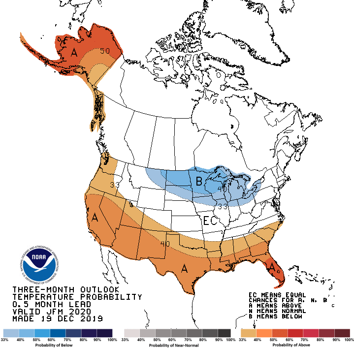
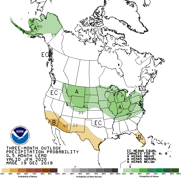
The CPC 6-10 day outlook (December 24-28) favors above-normal precipitation across the Southwest, Plains, and upper Midwest, and in southern and eastern Alaska. Subnormal precipitation is likely along the Atlantic Coast and Montana. Temperatures are expected to average below-normal in the Far West and Alaska, with good odds for unseasonably mild readings in the eastern half of the Nation.