#Drought news: E. & W. #Colorado had a large expansion of extreme drought

Click on a thumbnail graphic to view a gallery of drought data from the US Drought Monitor.

Click here to go to the US Drought Monitor website. Here’s an excerpt:

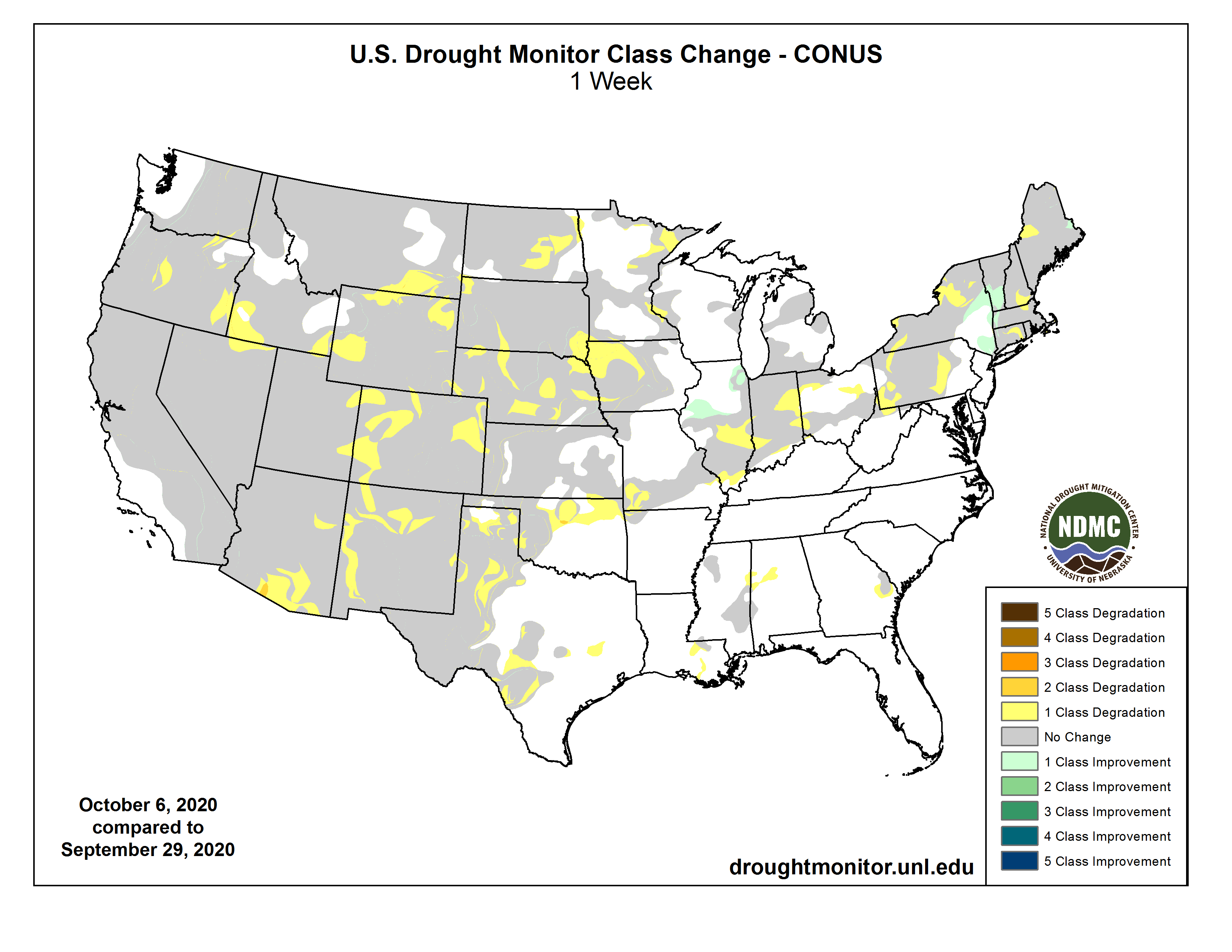
This Week’s Drought Summary

Temperatures for the week were below normal over much of the Plains, Midwest, South, Southeast and Mid-Atlantic, with departures of 5-10 degrees below normal for many locations. The West continued to be warm with temperatures near normal to slightly above through the Rocky Mountains and 5-10 degrees above normal over the West Coast. Temperatures in New England were also slightly above normal, with the greatest departures in Maine. Below-normal precipitation dominated almost the entire country. Precipitation amounts were greatest over the eastern seaboard, with the Northeast recording the most rain. Almost no precipitation was recorded in the western two-thirds of the country. In the next several days, eyes will be on Hurricane Delta and where it will make landfall along the Gulf Coast. Current projections are taking the storm ashore in Louisiana…

High Plains

Cooler than normal temperatures dominated the eastern half of the region with departures of up to 6-8 degrees below normal while the western half was warmer than normal with departures of 4-6 degrees above normal. Precipitation was almost none existent in the region for the week, with only a few areas of light showers in portions of South Dakota and Nebraska. Moderate drought and abnormally dry conditions were expanded in portions of eastern North Dakota. In eastern, southwest and central Nebraska, severe drought expanded along with some expansion of moderate drought. Moderate, severe, and extreme drought also expanded in western Nebraska as the entire state continues to dry out. In South Dakota, moderate drought was expanded in the northwest while severe drought was expanded in the southeast. A new area of extreme drought was also introduced in southeast South Dakota. Extreme drought was introduced in far southwest South Dakota while moderate drought also expanded to the east. In northeast Wyoming, moderate drought expanded while severe drought expanded slightly in the southeast. Eastern Colorado had a large expansion of extreme drought conditions while severe drought expanded in the northeast…

West

Hot and dry continues to be the theme of the region and also the monsoon season that was minimal at best, all of which is providing the conduit for continued deterioration in the region. Over the last 6 months, Arizona and California have had their warmest April–September period ever in 126 years, with New Mexico and Nevada the 2nd warmest. During that same 6-month period, Utah and Arizona have also had their driest period ever, with New Mexico having their 2nd and Colorado their 3rd driest. In Arizona, the new established record for statewide precipitation was greater than 2 inches drier than the previous record. During the current week, temperatures were warmest along the coast, where departures were 5-10 degrees above normal for the week. Drought intensified and expanded over southeast Montana and into northwest Wyoming where moderate, severe, and extreme drought all increased in coverage. A new area of moderate drought was introduced in southwest Wyoming and into southeast Idaho. Western Colorado and eastern Utah had large expansions of exceptional drought, and this also went into northwest New Mexico. Extreme drought also expanded over north central Colorado. Western and northern New Mexico as well as northeast Arizona had severe and extreme drought expand while a new area of extreme drought was introduced in eastern portions of New Mexico. In southern Arizona, extreme and exceptional drought also expanded in coverage. In Idaho, abnormally dry conditions and moderate drought expanded over the southeast and southwest portions of the state as well as into southeast Oregon. Central and northeast Oregon also had expansion of severe and extreme drought this week…

South

Although most of the region received no precipitation during the week, cooler temperatures helped to reduce the amount of drought expansion this week as temperatures were generally 3-6 degrees below normal. Abnormally dry conditions and moderate drought were expanded over northern Oklahoma this week while extreme drought expanded over the southwest portions of the state. Abnormally dry conditions expanded over portions of southern Louisiana and eastern Mississippi while moderate drought and abnormally dry conditions expanded over northwest Arkansas. Texas continued to see conditions deteriorate over the panhandle and areas of the south Texas Plains and into the Hill Country.

US Drought Monitor one week change map ending October 6, 2020.

Even in a pandemic, #drought drives water use along the Front Range — @AspenJournalism

Golfers take shots on the green lawns of the City Park Golf Course in central Denver on Sept. 28 2020. Urban utilities this summer saw sharp increases in single-family home and outdoor water use, primarily due to drought. Photo credit: Lindsay Fendt/Aspen Journalism

From Aspen Journalism (Lindsay Fendt):

The COVID-19 pandemic has dominated much of life and the economy in 2020, but when it comes to water use along the Front Range, drought is still the ruling force.

Most municipal water providers saw commercial water use plummet at the beginning of the pandemic, but those savings were quickly erased once the hot summer rolled in and the region’s residents switched on their sprinklers.

“The increase in residential and irrigation use have more than offset the decrease in commercial use, resulting in above normal water use across the service area,” said Todd Hartman with Denver Water. “The short story from our perspective is that we are seeing higher use this watering season because of very hot, dry conditions.”

The entire state of Colorado has been under some level of drought since early August, meaning that grass, shrubs and trees need more water than normal. To make up for that increased demand, Front Range communities have to rely more on the Western Slope water contained in their reservoirs.

In a typical year about 48% of Denver’s water comes from the Western Slope, while Colorado Springs pipes in about 75% of its water from the other side of the divide. Fort Collins typically gets more than half of its water from the Western Slope and Aurora Water gets 25% of its water from sources within the Colorado River basin.

Even though most of western Colorado is now in an extreme drought, Front Range water providers are able to rely on their storage from previous years to provide that additional water and then refill the reservoirs during the next snowmelt season.

Northern Water manages the Colorado Big-Thompson project, which pumps water from west of the Continental Divide to municipal and agricultural users along the northern Front Range. During a drought, the water district’s board generally increases the amount of water per share of the project that it doles out, known as a quota, allowing more water to be drawn from its reservoirs and increasing the amount of water delivered to shareholders. In a typical year, the project delivers about 217,000 acre-feet of water to its users. This year, to make up for drought, the board gave users an additional 31,000 acre-feet of water.

“The more water that’s available on the Front Range, like through soil moisture and local storage, the lower the quota we set because the rest of the demand can be furnished by local sources,” said Jeff Stahla with Northern Water. “The drier it is then the higher the quota, because we’re supplementing.”

Dillon Reservoir in late August 2020. The reservoir is the largest in Denver Water’s collection system, which delivers water to 1.5 million people. With drought leading to increased water use this year through August, Front Range water providers have had to rely more on water stored in reservoirs. Photo credit: Lindsay Fendt/Aspen Journalism

Outdoor watering dominates

The data from the year so far show just how overwhelming a factor outdoor water use is on overall water-use trends. Even in a pandemic, the watering needs of yards on the Front Range during drought seem to supersede any other behavior changes. In a typical year, 40% of urban water use on the Front Range is for outdoor use. That number often increases during a drought.

Preliminary consumption numbers for the year through August show single-family use up in Denver by about 20% and multi-family use up 5%. Industrial use is down 5%, office buildings are down 9% and restaurants — which remain under limited operations due to the pandemic — are down a whopping 31%. Altogether, Denver Water saw a 12% increase in water use system wide this year, through August. The increase in single-family use began in May when many home irrigation systems were likely first turned on. Other Front Range cities saw similar trends.

Because the pandemic overlapped with a hot, dry summer, it’s been difficult for utilities to determine how much of an effect either event had on overall water use. The most revealing data comes from the spring when businesses closed and most people had yet to turn on their sprinklers.

At Aurora Water, the water conservation team started pulling data early in the pandemic to see if any trends emerged. Between March and April — right as the state transitioned to a stay-at-home order — Aurora saw a commercial water use drop of 14.3% accompanied with an 8.8% increase in residential water use and a 4.6% increase in multi-family use.

But according to Tim York, a water conservation specialist at Aurora Water, the modest increases in residential water use skyrocketed once irrigation season began. Commercial use also ticked back up once businesses began reopening. According to York, Aurora Water saw a 10.3% system-wide increase from January to July that they attribute almost entirely to drought conditions.

“Indoor use kind of is what it is, right? I mean, you’ve got to use the toilet as many times as you need to, you’ve got to do dishes when they’re dirty, you’re going to take your showers just like you normally would, but people react differently to weather,” York said.

A couple sits at the edge of the lake at City Park in central Denver on Sept. 28 2020. In a typical year, about 48 percent of Denver’s water comes from the Western Slope. Photo credit: Lindsay Fendt/Aspen Journalism

‘People are home and wanting to work on their yards’

Most utilities had an adequate amount of water storage going into the summer to make up for the increased water use. Denver, Colorado Springs and Aurora have maintained their normal summer watering restrictions, which include guidelines on when and how often to water outdoors.

On Oct. 1, Fort Collins went under mandatory level IV water restrictions in order to avoid a water shortage in the fall. In most cases residents are no longer allowed to water their lawns and cannot wash their cars. The restrictions are due partially to drought conditions and some planned maintenance on water infrastructure, but the city is also taking preemptive measures to conserve water in case the Cameron Peak Fire begins to affect the water quality in the Poudre River.

Though the drought has been the driving factor in water use this year, water managers say that the pandemic likely did have some effect on behavior and might even pay dividends down the line. Abbye Neel, a water conservation specialist in Fort Collins, says the city has seen a large increase in its Xeriscape Incentive Program. The program provides rebates and project support for Fort Collins residents to redesign their yards to be more water-efficient.

“I have nothing to back this up, but I think it’s just like people are home and wanting to work on their yards,” she said. “There’s a high potential to do more projects this year as people actually get their ducks in a row and sign up.”

This story initially ran online in the Sky-Hi News on Oct. 3 and in print in the Summit Daily News Oct. 4.

Respecting property rights a focus in water speculation task force meeting — The Grand Junction Daily Sentinel #COleg

Water from an aquifer that lies below Colorado’s San Luis Valley flows through a center-pivot irrigation system, one of some 14,000 that draw water from below. Photo credit:Luna Anna Archey/High Country News

From The Grand Junction Daily Sentinel (Dennis Webb):

The Colorado Department of Natural Resources on Wednesday held the first meeting of the Anti-Speculation Law Work Group. The task force was established as a result of passage of a bill this year to consider ways to strengthen the current anti-speculation law and recommend any changes to a legislative committee by Aug. 15 [2021].

The bill was sponsored by state Reps. Dylan Roberts, D-Avon and Marc Catlin, R-Montrose, and Sens. Kerry Donovan, D-Vail, and Don Coram, R-Montrose. It was inspired by a growing number purchases of agricultural land and associated water rights by investment firms, including wide-scale purchases in the Grand Valley by Water Asset Management, which is based in New York.

Current state law prohibits water speculation by requiring water to be used for a beneficial purpose. An 18-member work group made up of state agency staff, water lawyers and others will be considering how the law might be tightened.

None of the bill sponsors participated in Wednesday’s meeting. But Scott Steinbrecher, an assistant deputy attorney general co-chairing the task force, said a clear purpose of the bill is to examine how the law should be strengthened to prevent situations where water rights are bought and leased back to farmers though the intent is to use the water like an investment.

Alex Funk, a task force member who is an agricultural water resource specialist with the Colorado Water Conservation Board, a state agency, voiced concern about approaches that might limit the value of assets to agricultural producers.

“There is certainly a tension here where land and water assets are extremely valuable to producers. In some cases these are sort of their only asset,” he said…Task force member Peter Fleming, general counsel for the Colorado River District, which has been watching some of the area water-related acquisitions by investment firms with concern, said agricultural producers looking to sell their assets are entitled to do that.

“I assume we don’t want to prevent that from happening,” he said.

He said what’s important under even the current law is the intent of the buyer of water rights. He said they can profit from the water’s use but their end goal in buying rights can’t be the pure value of the water, and he’s interested in looking at ways to determine intent.

Daris Jutten, a rancher in the Uncompahgre Valley, said his interest in serving on the task force is considering impacts on property rights.

“I want to keep the land value prices where they are but I also don’t want to see buy and dry,” he said.

He was referring to situations in which transactions result in water no longer being used to irrigate agricultural land and instead going for other uses such as by municipal utilities.

Task force member Joe Frank, general manager of the Lower South Platte Water Conservancy District, said the district sees entities buying up water there with the intent to dry up land in the future.

“In addition to that we do have those who want to sell, so water is a property right. … It’s a dilemma, but we don’t want to impact people’s property rights,” he said.

Hydrology Data Tool Helps Users Manage Water Resources, Protect Infrastructure — North Carolina State University

River system withdrawal 2020. Photo credit: Edvin Johansson via North Carolina State University

Here’s the release from North Carolina State University (Sankar Arumugam, Sudarshana Mukhopadhyay, Matt Shipman):

River systems are essential resources for everything from drinking water supply to power generation – but these systems are also hydrologically complex, and it is not always clear how water flow data from various monitoring points relates to any specific piece of infrastructure. Researchers from Cornell University and North Carolina State University have now developed a tool that draws from multiple databases to give water resource managers and infrastructure users the information they need to make informed decisions about water use on river networks.

“A streamgage tells you what the water level is at a specific point in the river – but that’s not really enough information,” says Sankar Arumugam, co-author of a paper on the work and a professor of civil engineering at NC State. “If you are an infrastructure operator, what you really need to know is how long it will take for that water-level information to be relevant to your infrastructure. How far away is the streamgage from your water intake along the river path, not just as the crow flies? How closely connected are those two things, hydrologically?”

“This information is important for managing water systems efficiently, for ensuring that infrastructure – such as power plants – are able to continue operating, and for protecting the infrastructure,” says Sudarshana Mukhopadhyay, first author of the paper and currently a postdoctoral researcher at Cornell University. “The information is particularly important during extreme conditions, such as flooding or drought.

“All of that data already exists, it’s just scattered across separate databases. We’ve developed an algorithm that efficiently pulls all of that information into one place and accounts for how the streamgages and the various infrastructure sites are hydrologically connected over a large watershed,” says Mukhopadhyay, who worked on the research as a Ph.D. student at NC State.

To demonstrate the tool’s utility, the researchers used the algorithm to create a connectivity network demonstrating the interconnectedness of about 1,400 reservoirs and 1,600 streamgages in the upper and lower Colorado River basins.

For this network, the algorithm used data from three sources: topographic information from the U.S. Geological Survey’s (USGS) National Hydrographic Dataset; streamgages from the USGS National Water Information System; and reservoir data from the National Inventory of Dams.

“This is a tool that can be used by power plant operators, reservoir operators, water resource managers – really it’s for anyone who draws water from the river system,” Mukhopadhyay says. “It can inform them about river conditions both upstream and downstream, and help them make decisions about where they should draw water from the system.”

The researchers have also made a template publicly available, allowing anyone to develop similar connectivity networks for other watersheds.

“It should be fairly easy for water resources professionals,” Mukhopadhyay says.

“We are currently working on a national version, which we think will help us better understand all of the ways that river basins connect infrastructures across the country,” Arumugam says.

The paper, “Developing the hydrological dependency structure between streamgage and reservoir networks,” is published open-access in the journal Scientific Data. The paper was co-authored by Chandramauli Awasthi, a Ph.D. student at NC State.

The work was done with support from the National Science Foundation, under grants 1823111 and 1442909; and from the USGS Powell Center Working Group Project “A global synthesis of land-surface fluxes under natural and human-altered watersheds using the Budyko framework.”