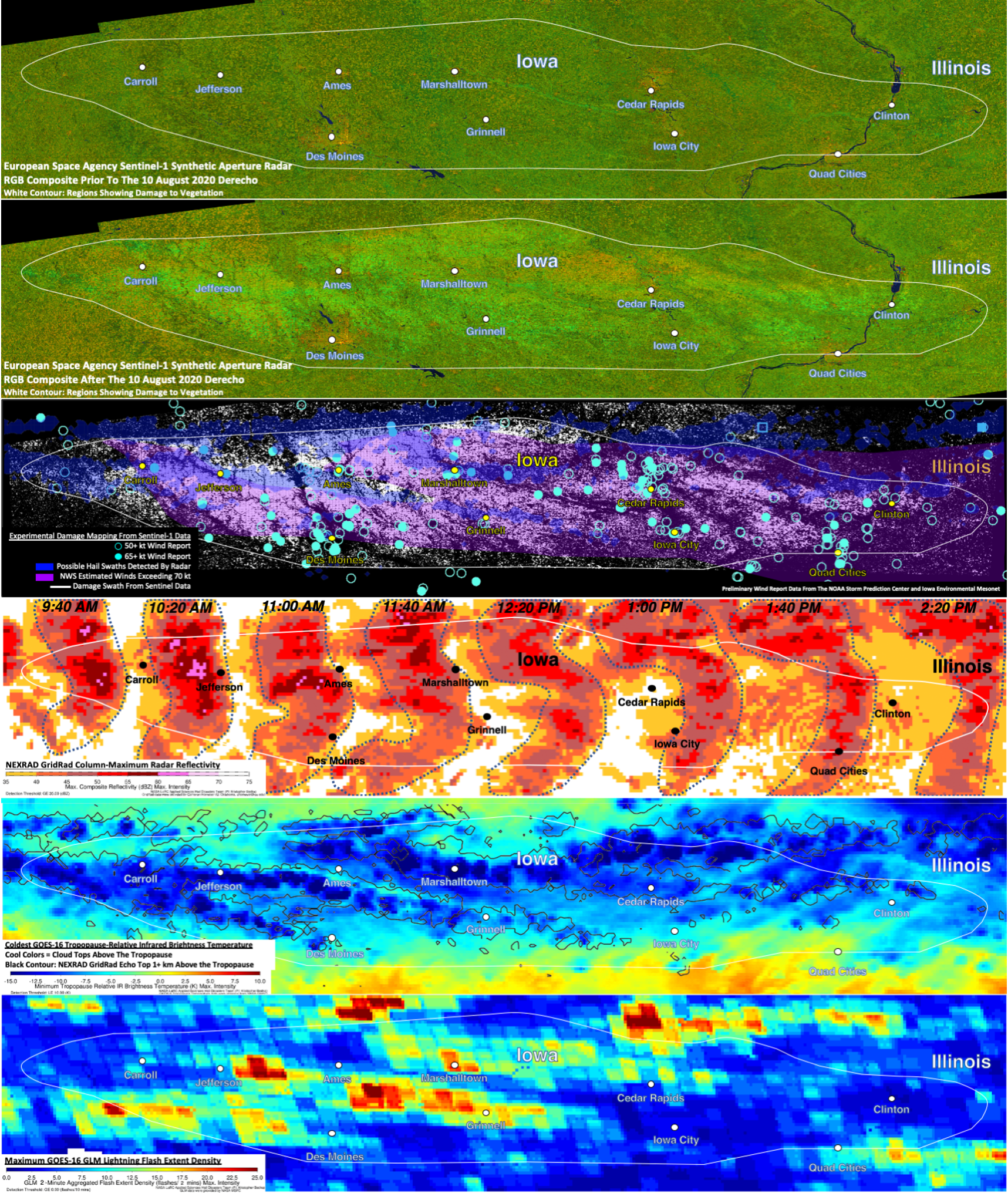
A team of NASA researchers used this satellite and radar imagery to help officials in Iowa better understand the effects of a derecho that ripped through the state in August. Credits: NASA, University of Oklahoma, the NOAA Storm Prediction Center, National Weather Service, and the Iowa Environmental Mesonet
The powerful, fast-moving, line of thunderstorms known as a derecho, blasted across Iowa Aug. 10 with extreme winds. The derecho did catastrophic damage to corn and soybean crops, caused widespread utility and property damage, and resulted in fatalities. NOAA estimates damage totals to be $7.5 billion, making it one of the most costly severe thunderstorm events in U.S. history.
To help officials in Iowa better understand the scale and scope of the disaster, a team of NASA researchers, led by Kris Bedka, a severe storm expert at NASA’s Langley Research Center in Hampton, Virginia, and colleagues at NASA’s Marshall Space Flight Center in Huntsville, Alabama and the University of Oklahoma, analyzed the storm using data and imagery from multiple Earth-observing satellites and weather radars on the ground.
“We’re trying to understand and demonstrate how state-of-the-art satellite and radar data can be used to identify the most intense areas of the storm and the damage they produced,” said Bedka.
His team’s analysis is helping to reveal a layered picture of a storm that was historically intense — even for a derecho.
“There’s evidence based on damage patterns in pockets throughout the state of Iowa that they saw winds exceeding 140 mph, which is extremely uncommon in these derecho systems,” said Bedka. “I mean, 100 mph is usually kind of your upper end. When you get to 140, that’s just a whole new level.”
These winds weren’t sustained like they’d be in a hurricane, but even just a minutes-long burst of 140 mph wind is enough to do significant and lasting damage to vegetation and structures.
The imagery Bedka and his colleagues analyzed — visible in the compiled image series above, with the swath of the state that took the most damage outlined in white — showed remarkable agreement between what was happening in the clouds and the damage patterns the ground.
The first two images in the series are color composite synthetic aperture radar visualizations of ground vegetation taken by the European Space Agency’s Sentinel-1 satellite — the first before the storm, the second after. In the second image, the lighter green and some brown areas show large areas damaged by wind and, in some cases, hail, which can strip vegetation of its leaves.
The third image in the series superimposes ground wind reports, radar-detected swaths of possible hail and National Weather Service (NWS) wind estimates with the damage patterns visualized in the second image.
In the fourth image, which comes from several NWS NEXRAD Doppler weather radars, the maroon and pink represent areas of high reflectivity, a telltale signature of hail. Also, the pattern of the radar echoes changed as the derecho moved across Iowa, becoming more arc-shaped. The arc, often referred to by meteorologists as a “bow echo,” indicates where the strongest winds were occurring, which is aligned well with NWS estimates and damage evident in the Sentinel-1 data.
“Because of how the instrument aboard Sentinel-1 collects data, we were able to compare data acquired both pre- and post-derecho to understand how the structure of vegetation, especially mature agricultural crops, were impacted and changed,” said Jordan Bell, research scientist in the Earth Science Branch at Marshall. “Synthetic aperture radar is being used for more and more applications, so it was exciting to provide impactful analysis for this event.”
The cool blues in the next-to-last image from the National Oceanic and Atmospheric Administration’s Geostationary Operational Environmental Satellite East-16 (GOES-16) represent areas where tall, cold clouds that penetrated deep into the stratosphere were likely driving powerful wind downbursts. These are also areas where updrafts suspend water droplets long enough to form hail.
The warm yellows and reds in the final image, also from GOES-16, are areas of high lightning flash density, another indicator of storm intensity.
This layered analysis has been a valuable resource to Justin Glisan, state climatologist in the Iowa Department of Agriculture and Land Stewardship, as he continues to unravel what happened.
“The remote sensing products produced by the NASA team have given us a tremendous set of tools to study the agricultural damage produced by the Aug. 10 derecho event that impacted 57 of Iowa’s 99 counties, one of the most significant weather events Iowa agriculture has experienced,” said Glisan. “As state climatologist of Iowa, having these additional and remarkable products in the toolbox will provide excellent guidance as we continue analyzing this catastrophic event.”
The analysis has even been useful to officials in neighboring Illinois, which also experienced severe weather from the derecho as it plowed east into the northern part of the state.
“In the several days after the event I was reaching out to folks around northern Illinois to try to determine the extent and severity of damage. Unfortunately, that kind of search usually turns up photos and reports of the most severe damage, but no context as to the extent of that damage,” said Trent Ford, climatologist with the Illinois State Water Survey at the University of Illinois. “The satellite data and analysis shared with me by Kris and his team were very valuable to both better understand the extent of derecho damage and confirm reports of severe damage in both northwest and northeast Illinois.”
This project was funded by NASA’s Earth Science Disasters Program.
FromThe Associated Press via ConstructionEquipmentGuide.com:
As part of its corporate farewell to Denver, Molson Coors Beverage Co. vowed last fall to invest hundreds of millions of dollars in the company’s brewing plant in Golden, Colo., the second-largest beer-making facility in the world. Now the scope of that work is coming into focus, and heavy machinery is on the horizon in Jefferson County…
G150, scheduled to stretch into 2024, will completely overhaul the infrastructure between the company’s Golden brewhouse and the packaging facility at the massive plant. New, more-efficient fermenting, aging and filtration facilities will be built. The so-called “government cellars” where beer is stored prior to packaging will also be replaced with a state-of-the-art upgrade, Coors said. That building dates back to the 1950s…
The existing fermenting, filtering and storage facilities aren’t being removed as part of the work, Coors said. Instead, they will be abandoned in place. The new tank farms coming as part of the project will be replacing surface parking lots and ponds on the property…
New facilities will mean much greater efficiency, Peter J. Coors said, something he expects to benefit the business and the environment. When it’s all said and done, G150 should mean 25 percent less beer waste and 15 percent less energy usage on an annual basis. Water usage at the plant should decrease by 100 million gallons per year…
Golden Mayor Laura Weinberg lauded the focus on reducing energy and water usage at the plant through the project.
“The city of Golden is committed to a sustainable future and its wonderful to know that Molson Coors has that same commitment as well,” she said at the groundbreaking.
Coors Brewery in Golden Colorado. Photo credit: Molson Coors via Westword
The Cameron Peak fire, a few miles west of Fort Collins, Colorado, has engulfed over 200,000 acres and it’s still growing. It has now become the biggest wildlife in Colorado history.
What’s more astounding is that the Cameron Peak fire is the second fire in 2020 to hold the title of largest wildfire in Colorado history. The Pine Gulch fire near Grand Junction briefly held that title, but for only 7 weeks, having burned 139,000 acres in late summer.
Looking at this in a vacuum, you might think of it as mere coincidence. But zooming out, you need only look two states away in California to find evidence of more unprecedented fires. Six of the 7 largest wildfires in California history have all burned in 2020, and the largest, the August Complex fire, became the state’s first ever gigafire — meaning it burned over 1 million acres, scorching more acreage than the state of Rhode Island.
The Cameron Peak fire soon after it started on Aug. 13, 2020. By Sept. 11, the fire had grown to more than 102,000 acres (now >200,000 acres) and was not expected to be considered out until Oct. 31. Photo credit: InciWeb via The Colorado Sun
This year Mother Nature has supplied us with smoking-gun evidence to prove what climate scientists have been warning about for decades. The scorched-earth impacts of climate change have arrived…
“Our 2020 wildfire season is showing us that climate change is here and now in Colorado. Warming is setting the stage for a lot of burning across an extended fire season,” says Dr. Jennifer Balch, professor of fire ecology and director of Earth Lab at the University of Colorado Boulder.
According to Balch, Colorado in the 2010s saw a tripling of average burned area in the month of October, compared to the prior three decades of the 1980s, 1990s and 2000s. “We do see fall fire events in Colorado, related to fast, downslope winds. But to see multiple events start this late, in the middle of October, is very, very rare.”
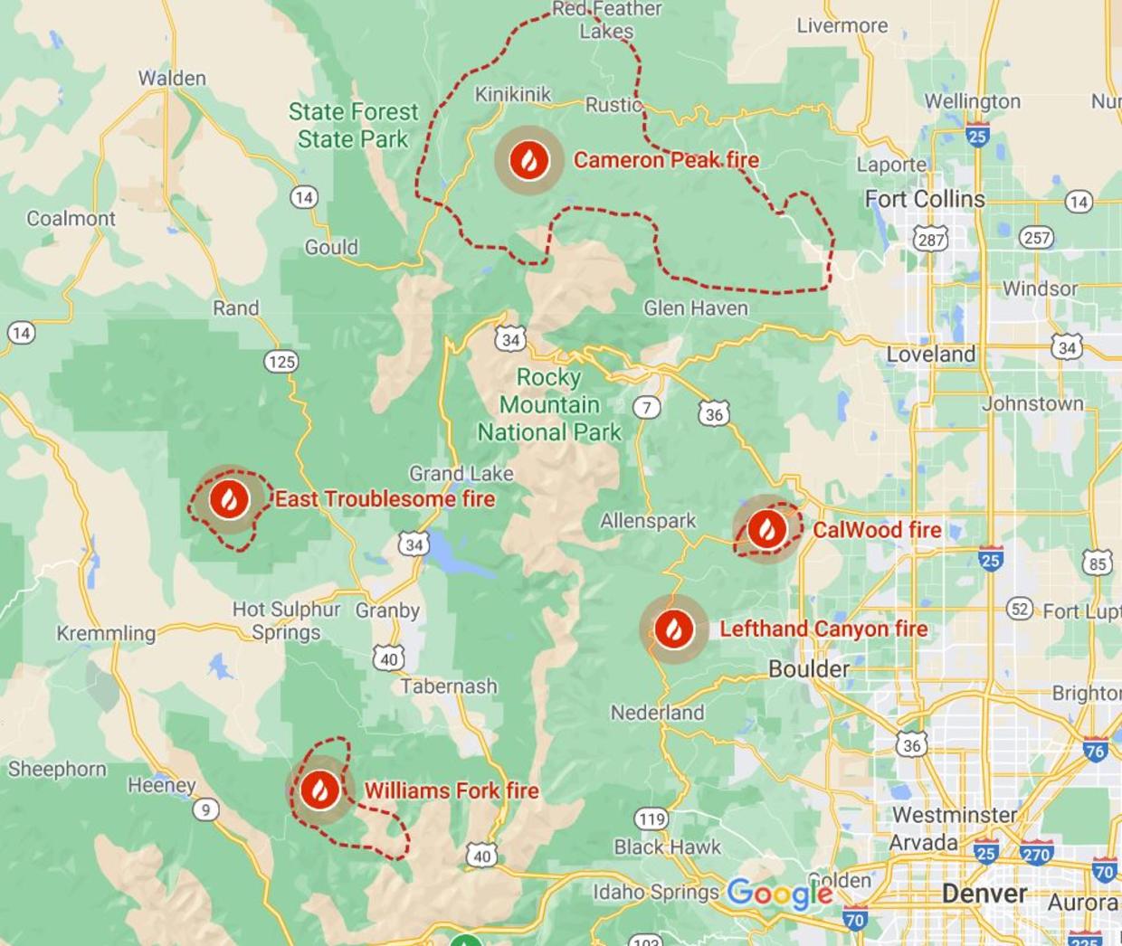
Perhaps it’s rare, but as of Monday 10 notable fires are burning across the state. The Cameron Peak fire’s eastern extent is just 5 miles from Fort Collins and Loveland.
Locations of Colorado wildfires as seen October 19, 2020. Credit: GOOGLE MAPS
Two of the most concerning new fires are burning in Boulder County and forcing evacuations. The CalWood fire — the largest fire ever in Boulder County — and the Lefthand fire have both exhibited extreme fire behavior, shocking even seasoned climate scientists.
“Even as a scientist studying extreme weather & wildfire in a warming climate, I was shocked by how fast #CalwoodFire roared down the Colorado Front Range foothills,” Daniel Swain, a climate scientist at UCLA, wrote on Twitter, posting video of a swirling vortex of smoke.
Even as a scientist studying extreme weather & wildfire in a warming climate, I was shocked by how fast #CalwoodFire roared down the Colorado Front Range foothills this afternoon. This is footage of one of several large fire vortices I observed while leaving area. #COwx@nplareaupic.twitter.com/9yJRdNo14X
While you can’t completely separate short-term variability from longer-term climate trends, as they are intertwined, a region’s most recent weather conditions are a big factor in how extreme a fire season is.
According to the Colorado Climate Center at Colorado State University, for the first time since 2013 all of Colorado is experiencing drought. This is no run-of-the-mill dry spell — 97% of the state is in the “exceptional,” “extreme,” or “severe” drought categories. And it’s not just Colorado; much of the Southwest is bone dry.
West Drought Monitor October 13, 2020.
Brad Udall, the senior water and climate research scientist at the Colorado Water Institute at Colorado State University, said 2020 started out promising.
“This year was shocking because we had a decent winter and on April 1 we had 100% of snowpack,” he said. But things quickly turned disappointing. “With 100% of snowpack, you’d expect a decent runoff year. Instead, we ended up with 52% of what is normal.”
[…]
Udall says much of the poor runoff is a result of increased evaporation due to a very warm and dry spring and summer. Over the past few months there have been a number of significant heat waves in the West, two of which were of historic proportions. The extra added heat energy vaporizes spring snow cover, and the lack of new moisture provides nothing to buffer the loss.
In the Southwestern states, June through August rainfall was the lowest since 1895 and temperatures were the highest since 1895, according to NOAA. In Colorado so far, this year is the eighth warmest and second driest on record. Denver has experienced more 90-degree days than any year in its history.
“We’ve had next to no moisture over the last 3 months which is highly unusual. The Arizona monsoon often carries moisture to Colorado but this year it was a complete bust,” said Udall…
Udall says that while most of the droughts of the 20th century were caused by lack of rainfall, today’s droughts are mainly caused by increased evaporation due to warmer weather. But drought is usually referred to as a short-term issue, and what’s happening in Colorado is not temporary. He prefers the term aridification, because climate change, due to the burning of fossil fuels and the buildup of a heat-trapping carbon pollution blanket overhead, is systematically drying out the landscape.
To be sure, climate is not the only factor driving the explosion in burned area. Excess fuel buildup due to increased fire suppression in recent decades as well as increasing ignitions due to more human activity in forested areas do play a role. But experts say the marked increase can not be explained without longer-term warming and drying.
Climate change and “the recipe for large forest fires”
If you look back over the past century, parts of Colorado have been warming faster than anywhere else in the nation. According to data from NOAA and an analysis by the Washington Post, western and northern Colorado are warming at twice the average rate of the globe, having warmed about 3 to 5 degrees Fahrenheit since 1895.
A study published in September found that the frequency of combined heat waves and droughts — which are more impactful when they occur in unison — has increased significantly, especially in the western U.S. For example, the type of hot-dry event that would have been expected once every 25 years in 1950, now occurs five to 10 times every 25 years…
Colorado’s state climatologist Russ Schumacher agrees, telling Colorado Public Radio this is pretty well in line with climate predictions, “What we’re seeing here is indicative of the fact that when the hot, dry years come around, they’re hotter. … I think the frequency of these kinds of summers where we get in these hot, dry conditions is probably going to increase.”
Udall agrees, and warns we should get used to what he calls “the new abnormal.” “The climate system has a really good memory and the cycle of heat and dryness is hard to break,” he said…
The effects on the Colorado environment are apparent. Since the 1930s the water available from Colorado snowpack has decreased by 30%. As a result streamflow in the Colorado River has decreased markedly. In a 2018 study, Udall and co-authors found that 50% of the river runoff decline was due to higher temperatures.
And this more arid climate has huge impacts, with larger wildfires and a longer fire season. In fact, wildfire season in the West is now two to three months longer than it was in the 1970s. And since 1984, human-caused climate change has led to a doubling of the area burned in the Western states, with about 50%of the increase being attributed to increases in the dryness of fuel…
The unprecedented wildfires of the past few years have certainly illuminated just how vulnerable we are to a climate which no longer plays by the rules our parents and grandparents took for granted. And considering the warming and drying projected in the coming decades, scientists say the rules will just keep on changing, making it “unlikely that the records from 2020 will stand for long.”