From the Grand Junction Daily Sentinel (Dave Buchanan):
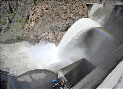
This year’s runoff is affected by the layers of dust on the snowpack, something you’ll still see in the West Elks, South San Juans and other mountain ranges. Chris Landry of the Center for Snow and Avalanche Studies in Silverton said the conditions this winter and spring correlated closely with 2006, when at least eight dust layers were buried in the snowpack. A warm spring quickly uncovered those dust layers and hurried snow melt. “That spring, we calculated snow melt advanced a full four to five weeks in our study area” in the San Juan Mountains, Landry said. “This year so far, we have counted at least 12 dust events and three very major dust events, which are now coming into play in a really intense way.” For water managers, that means the runoff, which normally (if normal ever exists in natural sciences) comes heavy in the spring and continues at lower rates for much of the summer, may be gone by early summer. Dan Crabtree, lead hydrologist for the Bureau of Reclamation in Grand Junction, noted Thursday that the expected volume of water in the Gunnison Basin this year was about the same as historic average, but the timing and intensity of runoff is much different. “We went about two weeks ahead of what that the (National Weather Service) Forecast Center told us the first of April,” Crabtree said…
The Bureau Web site (www.usbr.gov/ uc/) Thursday showed Blue Mesa reservoir as 77 percent full, a level usually not seen until later in the runoff period and a level that’s 150 percent of average on this date. Not surprisingly, Crystal Reservoir was listed at 108 percent full, which is why there’s water pouring over the dam. That glut of water came as a bit of a surprise, one reason for the sudden jump in flows on the Gunnison. Seasonal high flows are part of the water right for the Black Canyon of the Gunnison National Park, but it’s supposed to be a gradual rise and gradual drop. “Yeah, Wednesday it happened quicker than we wanted,” said Crabtree, sounding a bit rueful. “We have these guidelines (from the Division of Wildlife) and we try to follow them, but it’s more complicated than turning on your faucet at home.” The Crystal Dam was forecast to stop spilling Saturday morning. You can watch the change in river flows statewide at http://www.dwr.state.co.us/SurfaceWater/Default.aspx.
From the GOAT (Jonathan Thompson):
In March, the Bureau of Reclamation forecast a high lake level [Lake Powell] for this year at 3,642 feet, which is about nine feet higher than last year (which was celebrated by Lake Powell lovers since it was the highest the lake’s been since 2002, but still 60 feet below its 1998 level). But given the snowpack levels above Lake Powell for this year, and their precipitous drop in recent weeks, such projections may be dashed. After all, there was a lot more snow at this time last year. Indeed, some don’t expect Powell to get above 3,630 feet, and the NOAA’s most recent water supply outlook calls for slightly above average flows going into the reservoir this month, but below average flows after that.
From the Cortez Journal (Steve Grazier):
Regional river rafters and canoe paddlers wanting to experience the rapids of the Lower Dolores River should ready their water crafts within the next week or so for the best riding opportunities. Ken Curtis, an engineer with the Dolores Water Conservancy District, said lower river flows until the weekend should range between 1,800 and 2,200 cubic-feet per second with a downward trend expected for Saturday and Sunday. One cfs is equivalent to a water flow of 449 gallons per minute. “Basically, we filled the reservoir up and started spilling (Tuesday),” Curtis said. “We could have a spill go as long as 20 days on the high end of things. But the week ahead looks like plenty of spill.” Wednesday’s outflow from McPhee into the Lower Dolores River was at about 2,200 cfs, according to Vern Harrell, operations manager for the local U.S. Bureau of Reclamation office. He said the river should provide “raftable” flows for some time, possibly through the end of May. “We’re going to try to provide higher releases of 1,000 to 1,200 cfs for as long as we can,” said Harrell, who noted that a flow of approximately 800 cfs is considered good enough for rafting. “After the next 10 days, it looks like the inflow (to McPhee) will be dropping.” Spill releases are managed by the bureau, which calculates downstream flows according to the reservoir level, river inflow, and user demand for irrigation and municipal contracts via the Dolores Project. McPhee’s water capacity was listed at 378,311 acre-feet on Wednesday, according to the conservancy’s Web site, http://www.doloreswater.com. When full, the reservoir sits at just over 381,000 acre-feet. An acre-foot is equal to 325,829 gallons of water, or enough to fill an entire football field at the depth of 1 foot. Curtis noted the Dolores River Basin’s snowpack level reached only 93 percent of average this year, causing a smaller river inflow and outflow.
From the Steamboat Pilot & Today:
Several seasonal closures of the Yampa River Core Trail are in effect because of the high-running waters of the Yampa River. The closed sections of the Core Trail are the 13th Street underpass, the railroad underpass upstream of Fetcher Pond and the U.S. Highway 40 under pass at Wal ton Creek. Addi tion al closures are likely as stream flows continue to fluctuate.
From the Crestone Eagle (Keno):
The Great Sand Dunes National Park, just south of Crestone, also saw heavy snow, but not anywhere as much as the 26.8” Crestone received. In Moffat, 15” was reported; the middle of the San Luis Valley saw about 6” fall on average, yet to the west in Saguache and north to Villa Grove, only a couple of inches were recorded. Over on the eastern side of the Sangres, Westcliff reported between 5” to 7” of snow. There was little wind with this storm, but the snow fell heavy for several hours, averaging 2” per hour over a twelve-hour period.
Later in the week, as most snow from this storm melted away in the April sun, a new and massive snowstorm rolled across Colorado on Friday, April 17. This pesky storm, when at its peak in the late morning, deposited 7” of snow in just a two hour period. When it finally moved out the next day, 18.9” had fallen in Crestone, with some locations around town reporting over 22”. Unlike the first storm, most of Colorado felt this storm’s punch. With these two storms, Crestone broke several records, including most snow in April, with 47.3” (as of April 18) and the all time record for most snow in a season, with 99.0”. The old record for a snow season was 93.7”, set back in 1997-98.