
From the Associated Press (Jim Suhr) via The Denver Post:
Despite getting some big storms last month, much of the U.S. is still desperate for relief from the nation’s longest dry spell in decades. And experts say it will take an absurd amount of snow to ease the woes of farmers and ranchers.
The same fears haunt firefighters, water utilities and many communities across the country.
Winter storms have dropped more than 15 inches of snow on parts of the Midwest and East in recent weeks. Climatologists say it would take at least 8 feet of snow — and probably far more — to return the soil to its predrought condition in time for spring planting. A foot of snow is roughly equal to an inch of water, depending on density…
In the West, firefighters worry that a lack of snow will leave forests and fields like tinder come spring, risking a repeat of the wildfires that burned about 9.2 million acres in 2012. Scores of cities that have enacted water restrictions are thinking about what they will do in 2013 if heavy snows and spring rains don’t materialize…
That’s why [Nebraska farmer, Tom Schwarz] is worried about his 750 acres near Lexington in south-central Nebraska. To save his corn last summer, he pulled water from deep wells and other sources in his irrigation district, but the alfalfa he couldn’t irrigate died — something he has never had happen before. The soil was so dry he didn’t even try to sow winter wheat, a crop that is planted in the fall and goes dormant over winter, relying on snow as a protective blanket.
“If we don’t get snow, we’d better get rain this spring, or we’re done,” Schwarz said.
From the La Junta Tribune-Democrat (Candace Krebs):
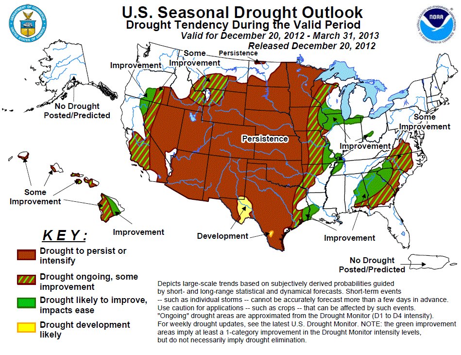
Colorado, Wyoming and Nebraska are all on track to record the driest year on record; the Midwest has been hit hard too. Climatologists at the National Drought Mitigation Center at the University of Nebraska have described this year’s drought as historically unusual in its speed of development, intensity and size. While a couple of recent winter storm systems brought welcomed snow to parts of the plains, going into 2013 it’s highly uncertain weather patterns will shift enough to improve range and crop conditions and replenish water deficits.
Well-known meteorologist Brian Bledsoe of KKTV in Colorado Springs is not optimistic. He gave what could only be described as a bah-humbug weather outlook during the Colorado Ag Classic. “Drought feeds on drought,” he said. “The longer it’s there, the worse it’s going to get.”
The eagerly anticipated El Nino weather pattern that began developing early in 2012 — expected to bring more moisture to dry regions of the country — instead turned out to be a scrooge, or what Bledsoe called “La Nada.”[…]
In addition, the current jet stream flow means fast-moving storm systems tend to skip over the High Plains before developing into more-organized storms further east. The last two snowstorms were textbook examples, moving through quickly and leaving marginal snow cover in many desperately dry areas.
Bledsoe ran through several medium-range climate models projecting a continuation of mostly dry weather through March. Spring could bring some relief to Oklahoma, Kansas and Nebraska, but prospects for Eastern Colorado were less encouraging. He called the April-May-June weather model for Colorado “horrific” and “really dry stuff.”
“It will be wet in the Midwest, Upper Plains and the Corn Belt,” he said. “In the summer, Kansas gets some moisture.”
High pressure will set up where the ground is hottest and driest, he added. That will make the Texas Panhandle “drought central” by next summer. Northern Colorado has the state’s best shot for getting some significant drought relief during that time period…
Longer term, the Pacific Ocean oscillation has shifted into a cold phase, which typically brings a dry trend to the High Plains as well.
“We’ve got another 20 years before it shifts out of this phase,” Bledsoe said. “Ranchers under 35 may want to look for a new line of work. We are reliving the ’50s right now. The parallels are unmistakable.”
As someone who runs a private meteorology consulting service advising farmers and ranchers in Colorado and surrounded states, Bledsoe added, “If you do not have a drought plan for your outfit, you better get one. Be prepared to capitalize on wet periods but realize it could be months before it comes back. Prepare for drought until we start getting regular moisture again.”[…]
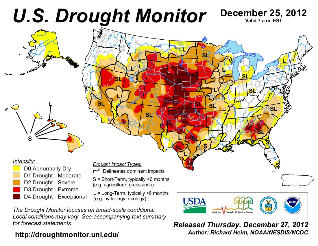
Heavy snows across the Rockies are also helping to replenish the anemic winter snow pack, a key source of irrigation water for next spring. On the eastern side of the Rockies, the snow pack remains alarmingly low, half of normal in some cases.
From the National Weather Service Grand Junction office:
…GRAND JUNCTION EXPERIENCED A VERY WARM AND VERY DRY 2012…
IN 2012, THE AVERAGE TEMPERATURE IN GRAND JUNCTION WAS 55.2 DEGREES. THIS TIED FOR 3RD WARMEST EVER ON RECORD, DATING BACK TO 1893. THE WARMEST EVER WAS 57.5 DEGREES IN 1934.
THE AVERAGE MAXIMUM TEMPERATURE FOR THE YEAR WAS 69.2 DEGREES, WHICH IS 2ND WARMEST ON RECORD… WHILE THE AVERAGE MINIMUM TEMPERATURE WAS 41.1 DEGREES, THE 17TH WARMEST.
IN 2012, THE PRECIPITATION TOTAL FOR GRAND JUNCTION WAS 4.53 INCHES. THIS IS THE 3RD DRIEST ON RECORD. THE DRIEST EVER WAS 3.64 INCHES IN 1900.