NOAA: 2012 hottest year on record in continental U.S. #COdrought

temperature2012statewideranksnoaa.jpg

Here’s the link to the National Climatic Data Center Annual State of the Climate National Overview for 2012. Click through for all the details. Here’s an excerpt:

In 2012, the contiguous United States (CONUS) average annual temperature of 55.3°F was 3.3°F above the 20th century average, and was the warmest year in the 1895-2012 period of record for the nation. The 2012 annual temperature was 1.0°F warmer than the previous record warm year of 1998. Since 1895, the CONUS has observed a long-term temperature increase of about 0.13°F per decade. Precipitation averaged across the CONUS in 2012 was 26.57 inches, which is 2.57 inches below the 20th century average. Precipitation totals in 2012 ranked as the 15th driest year on record. Over the 118-year period of record, precipitation across the CONUS has increased at a rate of about 0.16 inch per decade.

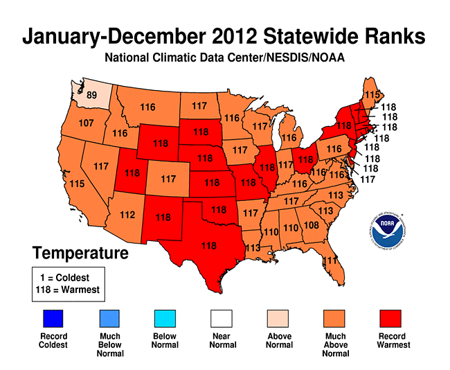
On a statewide and seasonal level, 2012 was a year of both temperature and precipitation extremes for the United States. Each state in the CONUS had annual temperatures which were above average. Nineteen states, stretching from Utah to Massachusetts, had annual temperatures which were record warm. An additional 26 states had one of their 10 warmest years. Only Georgia (11th warmest year), Oregon (12th warmest), and Washington (30th warmest) had annual temperatures that were not among the ten warmest in their respective period of records.

From the Summit County Citizens Voice (Bob Berwyn):

Most of the country was drier than average in 2012, reflected by the worst drought in the central part of the country since the 1950s.

Looking back, the winter of 2012 (Dec. 2011 – March 2012) was the fourth-warmest on record despite lingering La Niña conditions in the Pacific, with the third-smallest seasonal snowpack on record.

The spring season brought record warmth to nearly the entire country, with the warmest March, the fourth-warmest April and the second-warmest May on record.

Autumn (Sept. – Nov.) brought a return to somewhat more average readings, but the season still ranked as the 22d-warmest on record, with warm conditions in the West, but cooler than average readings along the Eastern Seaboard.

From The Washington Post (Juliet Eilperin):

Federal scientists said that the data were compelling evidence that climate change is affecting weather in the United States and suggest that the nation’s weather is likely to be hotter, drier and potentially more extreme than it would have been without the warmer temperatures.

Last year’s record temperature is “clearly symptomatic of a changing climate,” said Thomas R. Karl, who directs NOAA’s National Climatic Data Center. Americans can now see the sustained warmth over the course of their own lifetimes — “something we haven’t seen before.” He added, “That doesn’t mean every season and every year is going to be breaking all-time records, but you’re going to see this with increasing frequency.”[…]

Vanderbilt Law School professor Michael Vandenbergh said today’s leaders will be judged harshly by future generations for not focusing on climate change.

“A hundred years from now, they’re not going to be talking about health care or the fiscal cliff,” he said. “But they will ask, ‘What did you do when we knew we were going to have serious climate change?’ ”[…]

…many experts are engaged in a discussion over whether they should continue pressing for ambitious carbon cuts in the near term or adjust their goals in the face of the prospect of a much warmer world.

In 2004, Princeton University professors Robert Socolow and Stephen Pacala wrote an influential paper outlining how the world could stabilize its greenhouse emissions by mid-century through a series of “wedges,” using current technology, such as sharply increasing nuclear power worldwide, eliminating deforestation and converting conventional plowing to no-tillage farming.

Now, Socolow has published an article in the Vanderbilt Law Review that he describes as his “let’s get real here” lecture, in which he outlines what the world can realistically achieve over the next four decades. Environmentalists “don’t think it’s time to start the bargaining” on what’s an appropriate climate target, Socolow said, but they need to adjust some of their goals in light of the projected temperature rise.

Compromises include capturing and storing carbon from power plants, he added, “since I don’t think we can put the fossil fuel industry out of business.”

At the same time, some researchers are pushing for much steeper emissions cuts. On Wednesday, the journal Environmental Research Letters will publish a paper showing that although Socolow and Pacala projected emissions could be stabilized by cutting 175 billion tons of carbon emissions over 50 years, accelerating emissions over the past decade mean that it could require more than 500 billion tons of avoided emissions to achieve the same goal…

In the United States, a combination of high temperatures and dry conditions last year took a serious toll on the nation’s agricultural sector. NOAA’s Karl noted that the Midwest had been relatively wet for several years, which had curbed the impact of warmer temperatures.

In 2012, he said, “both the day and the nighttime temperatures were breaking their all-time records,” and that combined with drier conditions amounted to “a double whammy.”

The warmest March on record meant vegetation levels were 25 percent higher than normal that month, but many of those crops dried up because 39 percent of the United States experienced severe or extreme drought in 2012.

Forecast news: ‘Powerful winter storm possible late this week – NWS Grand Junction office #COdrought #COwx

screen-shot-2013-01-08-at-6-15-10-am.png.jpg

screen-shot-2013-01-08-at-6-19-39-am.png

From the National Weather Service Grand Junction office:

…POWERFUL AND COLD WINTER STORM TAKES AIM ON WESTERN COLORADO AND EASTERN UTAH ON FRIDAY…

A POWERFUL WINTER STORM IS EXPECTED TO MOVE ACROSS UTAH INTO WESTERN COLORADO THURSDAY NIGHT AND FRIDAY. THIS MAJOR WINTER STORM COULD BRING SIGNIFICANT SNOWFALL TO THE MOUNTAIN AND VALLEYS THROUGHOUT EASTERN UTAH AND WESTERN COLORADO. THE BRUNT OF THIS STORM HITS THE REGION ON FRIDAY…BUT WILL LAST INTO FRIDAY NIGHT. THE STORM INTENSITY WILL DIMINISH ON SATURDAY…BUT A CHANCE OF SNOW SHOWERS WILL LINGER.

THIS IS A DANGEROUS AND POTENTIALLY LIFE THREATENING WINTER STORM IF CAUGHT UNPREPARED. FACTORS THAT MAKE THIS WINTER STORM PARTICULARLY DANGEROUS…

SIGNIFICANT SNOW ACCUMULATIONS…MODERATE TO HEAVY SNOWFALL IS EXPECTED ON FRIDAY AS THE WINTER STORMS HITS THE REGION. THE POTENTIAL EXISTS FOR 1 TO 2 FEET OF FINE POWDERY SNOW ACROSS THE HIGH COUNTRY. SNOW IS EXPECTED TO BE WIDESPREAD AND WILL IMPACT TRAVEL WITH ACCUMULATING SNOW IN THE VALLEYS…THIS INCLUDES THE INTERSTATE 70 CORRIDOR FROM EASTERN UTAH TO VAIL PASS.

CONSIDERABLE BLOWING AND DRIFTING SNOW…THE FINE POWDERY SNOW WILL BE EASY TO BLOW AND DRIFT AROUND. COMBINED WITH STRONG WINDS ON THURSDAY NIGHT AND FRIDAY MORNING…WITH SOME GUSTS TO 60 MPH OVER THE MOUNTAIN PASSES OF SOUTHWEST COLORADO AND THE GRAND MESA…WHITEOUT CONDITIONS WILL BE POSSIBLE. GUSTY WINDS WILL PERSIST INTO FRIDAY AFTERNOON AND NIGHT THAT WILL FORM DEEP SNOW DRIFTS.

PLUNGING TEMPERATURES…RELATIVELY MILD CONDITIONS MAY EXIST BEFORE THE BRUNT OF THE WINTER STORM HITS. TEMPERATURES WILL PLUNGE AS THE SNOW INCREASES. MOUNTAIN READINGS IN THE 20S WILL DROP TO THE SINGLE DIGITS BY NIGHTFALL. SUBZERO TEMPERATURES WILL BE COMMON BY SATURDAY MORNING. HYPOTHERMIA AND FROSTBITE CAN OCCUR QUICKLY IF CAUGHT OUTDOORS COLD AND WET. OTHER RISKS INCLUDE CAR ACCIDENTS AND CARBON MONOXIDE POISONING.

Snowpack news: Wolf Creek ski area ideally placed to snag snowfall #COdrought #COwx

sanjuan.jpg

From The Pueblo Chieftain (Matt Hildner):

Anyone looking to hit the slopes last weekend would have seen a familiar sight if they were looking for ski areas that had the most snow. Wolf Creek Ski Area, which measured 39 inches of snow at mid­mountain for the New Year’s holiday, ranked right behind Steamboat with the most snow in the state and ahead of 19 other Colorado ski resorts. The ski area’s location in the eastern San Juan Mountains roughly 20 miles between South Fork and Pagosa Springs along Wolf Creek Pass makes for a lengthy hike for Front Range skiers and snowboarders. But that location makes all the difference when it comes to snowfall.

Storm systems that start off the coast of Southern California and the Baja California Peninsula roll relatively unobstructed across the southwest until they hit the San Juans and are forced upward. “Anytime you lift moist air, it causes precipitation to occur,” said Kathy Torgerson, a meteorologist for the National Weather Service in Pueblo. “They do a really effective job of wringing out the moisture.”
Wolf Creek, with a summit elevation of 11,900 feet, is perched right below the Continental Divide where the storm systems crest.

It’s the happy beneficiary of an annual average of 465 inches of snow, a figure the ski area touts as the most in the state. The heavy snowfall can be both the ski area’s best advertising and its biggest draw. Last year, an October storm allowed Wolf Creek to have its earliest opening ever and the ski resort rode it to a record 227,306 visitors. Over the past 15 years, its lowest total of 114,802 visitors came in the winter of 1999­-2000, a year in which snowpack across the upper Rio Grande Basin sat below 30 percent of normal in January and February.

Davey Pitcher, whose father bought the ski area in 1979, submitted plans to the U.S. Forest Service in the fall to expand the ski area, an expansion aimed, in part, at preserving powder conditions by spreading skiers out across the mountain. One of the proposed additions — the Matchless Pod — would add 715 acres for expert and advanced skiers for liftassisted backcountry­style skiing. The Pass Pod would add roughly 200 acres with much of the terrain suitable for beginner and intermediate skiers. The plans call for the construction of five new ski lifts.

DNR: COGCC Approves pioneering new groundwater monitoring protections

groundwatermovementusgs.jpg

Here’s the release from the Colorado Department of Natural Resources (Todd Hartman):

The Colorado Oil and Gas Conservation today approved pioneering new groundwater protection rules considered among the strongest in the country. The new regulations mark another innovative step in Colorado’s pacesetting regulation of this important industry.

The new groundwater protection rules require that operators sample nearby water wells both before and after drilling activities as a way to provide assurance that water supplies are not affected by energy development and identify potential problems in the very rare instances of impact. Only two other states have mandatory groundwater programs in place and no other state in the country requires operators to take post-drilling water samples.

“This new set of groundwater monitoring rules once again puts Colorado in the forefront of thoughtful and progressive regulatory oversight of energy development,” said Matt Lepore, director of the Commission. “We worked earnestly with many stakeholders to develop a groundwater rule that provides strong protections and that we believe strikes the right balance among many interested parties.”

Approval of the rule follows months of stakeholder discussions designed to craft a rule that protects well owners and the industry. These rules will generate the necessary data to help regulators determine whether oil and gas activities have impacted drinking water or whether other factors could be affecting groundwater. The new rules follow a successful year-long voluntary sampling program designed by operators and regulators.

“Our Commission has worked hard to arrive at an effective and reasoned place in developing this groundbreaking new rule,” said Commission chairman Tom Compton. “We have listened carefully and considered the views of many parties, including many citizens, and we believe this rule gets us to a result that rigorously protects the environment while addressing and incorporating the varied concerns of numerous interests.”

“This rule represents a strong, proactive step to monitor and protect our groundwater and is right for Colorado,” said commissioner Andy Spielman. “We have once again set the bar high in our assertive and judicious regulatory approach to oil and gas development.”

Colorado’s rules will require sampling up to four water wells within one-half mile of a new oil and gas well prior to drilling, and two more samples of each well between six and 12 months and again between five and six years, a requirement unprecedented among other states.

In the Greater Wattenberg Area (GWA) of northeastern Colorado, operators will be required to sample one water well per quarter section, pre- and post-drilling. The rule is adjusted in the GWA due to the combination of energy development, agriculture and other industrial and residential use unique to the area. In addition, the state program will exist side-by-side with a well-developed Weld County-led program that provides water well testing to any well owner requesting it.

The Commission has long amassed considerable data on water wells adjacent to oil and gas wells, and the agency’s database already contains well over 6,000 such samples – a data set that will grow substantially with the new rule. In the fall, the Commission took another important step by moving its water quality database on-line so that the public can review the same sampling data accessed by Commission regulators.

The Commission’s three-day hearing, which began today, continues through Wednesday at the Downtown Denver Sheraton Hotel, 1550 Court Place. Commissioners will spend the remainder of the hearing taking further testimony and deliberating in consideration of new rules designed to limit the impact of drilling near occupied buildings. Hearings begin at 9 a.m. each day.

From the Fort Collins Coloradoan (Bobby Magill):

The Colorado Oil and Gas Conservation Commission on Monday approved new rules requiring energy companies to test up to four domestic water wells within a half-mile radius of all new oil and gas wells both before and after drilling begins. The rule aims to ensure that drilling and fracking are not contaminating groundwater.

A slightly different rule applies in parts of Northern Colorado called the Greater Wattenberg Area. There, groundwater must be tested at least once within each quarter-section of the area, or every 160 acres, where new oil and gas wells are being drilled.

Statewide, the groundwater sampling rules are expected to cost the state and oil and gas industry $20.7 million, excluding the voluntary water sampling program energy companies have in place. The cost assumes about 1,850 new oil and gas wells are drilled statewide each year, COGCC Director Matt Lepore said.

The rules represent an effort by oil and gas regulators to protect Colorado’s groundwater, Colorado Department of Natural Resources Director Mike King said.

“Let’s be honest,” King said. “What we’re doing with this rule is trying to get the public comfortable.”

The rules, he said, “are an important piece of insurance” that build up the public’s comfort level with groundwater protection.

More oil and gas coverage here and here.