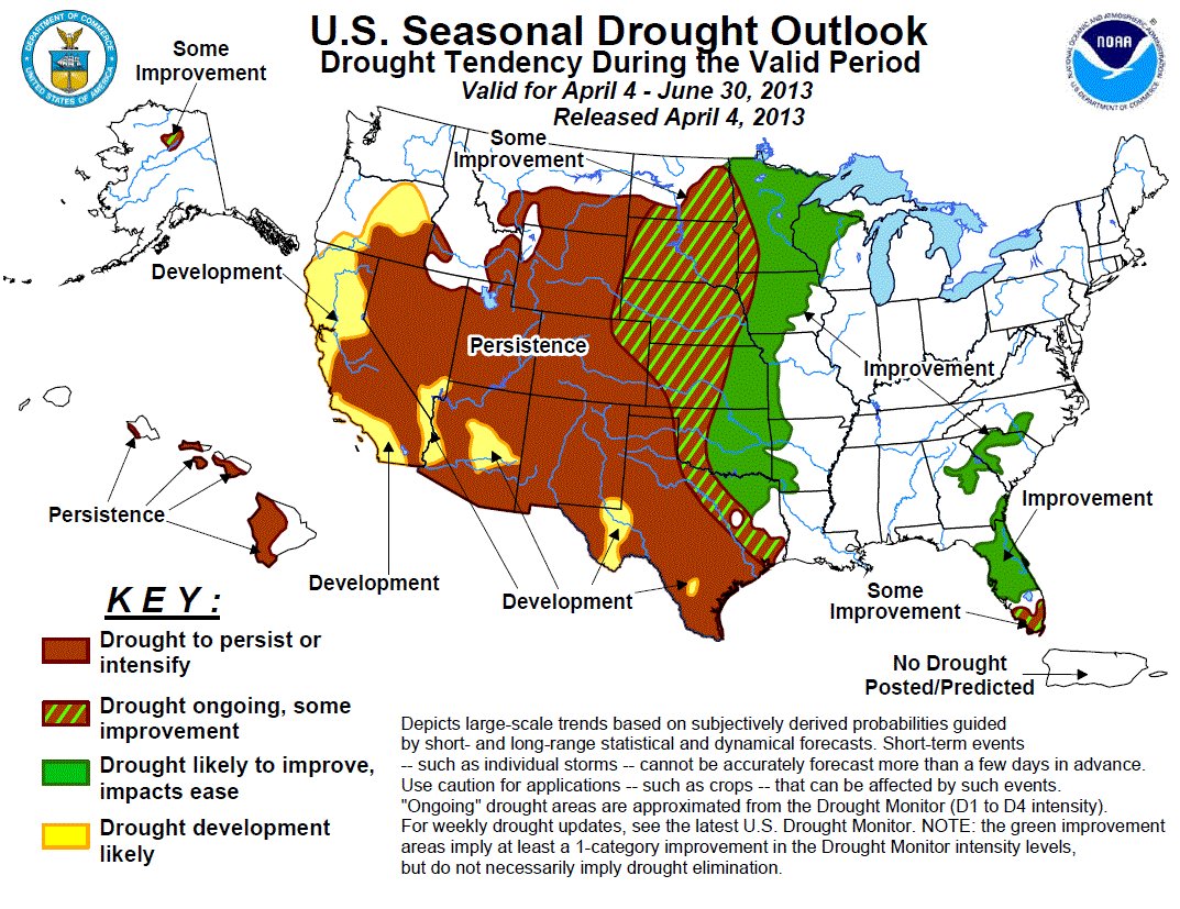

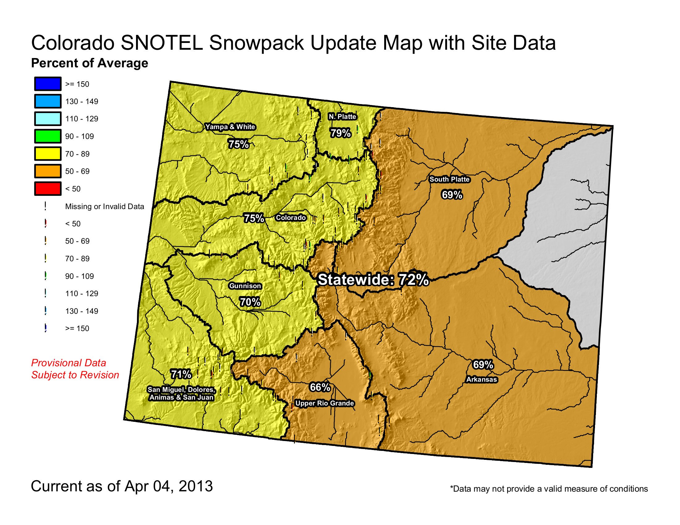
Click on the thumbnail graphics for the current Colorado statewide snowpack chart along with the current U.S. Drought Monitor map and the April-June drought forecast from the Climate Prediction Center.
From the Associated Press (Stephen K. Paulson) via The Denver Post:
On May 1, Denver Water and Colorado Parks and Wildlife will close Antero Reservoir in southeastern Colorado then drain it to save water. In Pueblo, Lake Minnequa is drying up, and a plan to use a pipeline to bring fresh water into the lake this summer offers little hope of filling it up.
The U.S. Drought Monitor shows that all of Colorado is experiencing some level of drought this year. A large portion of southeastern Colorado is seeing exceptional drought
Denver, Fort Collins, Colorado Springs, Aurora, Thornton and other communities are trying to limit watering. Colorado Springs will also charge large water users higher rates…
The Xcel Energy decision affects the Colorado River at the Shoshone Hydro Plant. The practice gives the upstream junior water rights holders the ability to store water once the spring runoff begins in earnest.
From The Denver Post (Jordan Steffen):
While there is little chance of reaching normal levels this season, snowpack in most areas hasn’t begun melting yet and in many areas continues to gather snow, assistant snow survey supervisor Mage Hultstrand said. “At this time last year, we had reached our peak snowpack for the year and the snowpack had already started to melt,” she said.
Typically, snowpack peaks and begins melting around April 8.
For the past 10 years, snowpack has begun melting earlier each season, said Brian Werner, spokesman for Northern Water, which helps provide water to 33 cities and towns in northeast Colorado. By mid-March last year, snowpack in several areas was completely gone. “In our business we like slow, steady melt outs,” Werner said.
Rapid and early snow melts often make it difficult to capture and store runoff.
All major basins in Colorado are expected to see below average runoff this spring and summer, according to the conservation service.
Reservoir levels in the state also remain below normal. As of April 1, average reservoir levels are at 71 percent of normal, 5 percentage points higher than this time last year.
From the Vail Daily (Randy Wyrick):
The good news is that the local snowpack is 143 percent of last year’s. The bad news is that last year was drier than comedian Steven Wright’s sense of humor. The Colorado River Basin — that’s us — jumped from 85 percent of last year’s snowpack on March 1, to 143 percent on April 1 and 74 percent of the historic normal, the Natural Resources Conservation Service said Wednesday in its monthly report. The statewide snowpack is 74 percent of average. “It’s great that we’re better than last year, but last year was the worst year on record,” said Diane Johnson with the Eagle River Water and Sanitation District. “We all know we’ve gotten some snow in March, it has stayed cold and we’re not melting like crazy like we were last year. But we’re still well below average.”[…]
Snow water equivalent is measured at several SNOTEL sites, including one on Vail Mountain. On Wednesday, the Vail Mountain SNOTEL site read 12.5 inches of snow water equivalent. Normal is 20 inches, so we’re at 62.5 percent of normal…
Reservoir storage in the Colorado River Basin — that’s still us — remains at dangerously low levels — 66 percent of average and 55 percent of last year’s totals. Streamflows are expected to lag well below average, the NRCS said. One reason is because we’ve in this drought for more than a year, Johnson said. “The land doesn’t have much moisture in it, so when you have a snowpack this low and it starts to melt, a lot of it gets absorbed into the soil,” Johnson said…
The snowpack in southwest Colorado is fading like the Colorado Avalanche Stanley Cup hopes. The Gunnison, Upper Rio Grande and the combined San Miguel, Animas, Dolores, and San Juan basins had declines of 3, 11 and 12 percent. In these basins it is likely that they have already reached their peak snowpack for this year and are beginning to melt…
Mother Nature might not be much help, according to long-range forecasters with Accuweather.
Another warm spring is expected across the Rockies, with worsening drought conditions in Colorado, Wyoming, South Dakota, Nebraska, Kansas, Oklahoma and portions of Texas.
“The core of warmth for the spring is going to center itself in the dry areas, the western Plains, east-central Rockies, maybe extending down into the Southwest mid- to late-season,” said Paul Pastelok, a long range forecaster with Accuweather. “Unfortunately for the western Plains and eastern Rockies, I think the drought is going to persist, and it is going to be strong going into the springtime.”
From the Albuquerque Journal (John Fleck):
Today’s Colorado Basin River Forecast Center briefing, and some followup email conversation with forecaster Brenda Alcorn, yielded some truly remarkable numbers:
forecast April-July inflow into Lake Powell, which is the largest reservoir in the Upper Colorado River Basin, at 2.7 million acre feet, is the lowest forecast since the federal center began issuing them in 1979.
The two consecutive runoff seasons, 2012 and ’13 April-July numbers combined, will be (if the forecast holds) the driest such two-runoff period since Lake Powell began operation in the 1960s.
From Reuters (Carey Gillam):
The “Drought Monitor” report, which tracks the U.S. land area stricken by drought on a weekly basis, said the Plains, which has been the hardest hit by the ongoing drought, was seeing improvement thanks to recent rains and snow. Drought Monitor has reported a slow retreat of drought conditions since February due to snowfall and rain showers. The improving conditions are closely monitored by agricultural experts as winter wheat crops are emerging after being planted last fall, and farmers are preparing to plant spring crops like corn and soybeans.
The report issued Thursday said:
* Nebraska, the most drought-stricken state in the nation, saw good improvement in the last week. While severe drought still grips 100 percent of the state, levels of “extreme” and “exceptional” drought declined slightly. Exceptional drought, the worst level, fell to 75.72 percent of the state, down from 76.16 percent, the report said.
* Top wheat-grower Kansas saw only a small decline in drought. Extreme and exceptional drought – the two worst levels were unchanged, but severe drought, the third-worst level, fell to 94.50 percent of the state from 95.10 percent.
* Oklahoma, another key wheat producing state, also saw drought levels decline over the last week, according to the Drought Monitor, though still more than 52 percent of Oklahoma was rated in extreme drought. That was down from 53.07 percent in extreme drought the prior week. Exceptional drought levels were unchanged at 9.90 percent of the state.
* Drought grew worse in Texas over the last week, the report said. All three levels of severe, extreme and exceptional drought expanded, with nearly 44 percent of the state now in at least severe drought, the report said.
From KUNC (Luke Runyon):
In drought years, cities hold on to their water supplies, selling little to no water to farmers. That forces many growers to limit the acres they plant and cut back on the number of workers they hire to get seeds in the ground and harvest crops in the fall.
In eastern Colorado, the situation’s even more dire. Thirsty cities have gobbled up water rights for decades, selling what they don’t need back to farmers, usually in the form of a lease back program. But that only works when there’s plenty of water to go around.
Kent Peppler grows corn and barley in the small town of Mead, Colo., which sits about an hour north of Denver. He’s seen the change firsthand. His neighborhood looks a lot different from how it appeared in the early 1970s, when he was growing his first crop of cucumbers as a teenager. Back then farmland and irrigation water was easy to come by.
“Now it’s all houses. No more cukes,” Peppler said…
Over the years, Greeley’s been buying up agricultural water rights. After the city meets its customers’ demands the leftover water is auctioned to farmers. “In normal years, we don’t need all this water and it should go to beneficial use in terms of agriculture production,” Monson said. “It’s only in those drought years, like this one might be, that we need to pull it back and use it for municipal supplies.”[…]
“The saying goes in Colorado that water runs uphill towards money. And that water that’s running uphill goes toward cities that have the money. It’s not the farmers that can afford to pay the going rate for water in this state any more,” Brian Werner, a spokesman for the Northern Water Conservancy District, which supplies water to close to a million people in Northeastern Colorado. Buying water rights on the open market now is incredibly expensive. Cities can afford the hefty price tag. Farmers often times cannot. Water used in the Colorado-Big Thompson project, Colorado’s largest water distribution project, currently costs about $20,000 per acre foot, or 325,000 gallons, to purchase the rights. Most years farmers pay about $30 per acre foot to rent the water from cities.
Werner said with the tight water rental market, many farmers will be forced to leave portions of their land fallow this growing season.
From The Watch (Samantha Wright):
With the Uncompahgre River Watershed snowpack still well below average, and little hope of enough new snowfall in April to make up the deficit, the City of Ouray is once again bracing for a water call from downstream senior water rights holders this summer.
Bob Hurford, Colorado Division of Water Resources Division Engineer for District 68, which encompasses Ouray County, confirmed that his agency expects the Uncompahgre Valley Water Users Association to place a call on the Upper Uncompahgre River with its Montrose & Delta Canal sometime in late April.
The call would affect not only the City of Ouray but other junior upstream water users, including Tri County Water Conservancy District which controls the water in Ridgway Reservoir.
The City of Ouray may be much further upstream than the M&D Canal’s multiple users, but proximity to a watershed’s headwaters does not factor into the complicated calculus of Colorado water law. What matters is who filed and adjudicated their water rights first. As the Colorado Division of Water Resources puts it: “The essence of a water right is its place in the priority system.” And when it comes to senior water rights on the Upper Uncompahgre River, the M&D Canal is the biggest (and oldest) dog in the fight.
Last year, when the M&D Canal placed a call on junior upstream water users because sub-average snow pack and early run-off had resulted in excessively low seasonal flows, the City of Ouray scrambled to augment its junior municipal water rights in order to avoid immediate curtailment of its water supply.
This year, the city is in better shape, having recently closed on a $72,000 deal several years in the making to augment its water rights through the purchase of the Red Mountain Ditch, a historic trans-basin diversion that starts in the Animas River Watershed near the top of Red Mountain Pass and is piped into the Uncompahgre River Watershed.
The long-neglected ditch, formerly owned by a ranching couple near Colona, represents a 6 cubic feet per second water right that would otherwise flow into Mineral Creek in the Animas River Basin. Ideally, this will be enough for Ouray to keep its municipal water flowing, while still satisfying the downstream demands of senior water rights holders during a call. “It’s a pretty good flow,” Rondinelli said. “That [6 CFS] would meet the majority of what we had called on us last year.”[…]
The city’s public works staff will begin eight weeks’ worth of work to rehabilitate the ditch (and maximize its water-carrying capacity) as soon as weather permits in the late spring. This work will consist of repairs of the diversion site on the Mineral Creek side, about 500 feet south of Black Bear road, where improvements will be made to the head gate and weir. “The ditch hasn’t been maintained for many years,” Rondinelli said. “There are minor blow-out spots where the bank has been eroded away. One section washed out in 2006 and will require significant repairs to the pipeline, structural beams and wing wall.”
From The Grand Junction Daily Sentinel (Gary Harmon):
The hope is for an eternal spring when it comes to snowpack in the Colorado high country. And if not eternal, then maybe at least through April. March left the western Colorado high country snowpack in better shape than the same month had a year ago, but that’s not the same as saying that the moisture stored among the peaks will easily recharge reservoirs and flood fields. “We don’t look as good as we did a month ago,” rancher Carlyle Currier said of the lands his cattle graze on and near Grand Mesa. “But it’s not melting like it was last year. We don’t have the wind and hot temperatures drying the ground out. “If we can still get some good April storms, there’s still the potential to have a decent year.”
Unlike last spring, when low runoff was offset by large amounts of stored water, reservoirs are low this time around and the prospect of them filling is dim. Already water managers are moving to keep as much water in liquid form as they can. Under an agreement with Denver Water, more water is being allowed to flow downhill for capture in high-elevation reservoirs than would otherwise be the case. That arrangement, however, can continue only until May 20. Green Mountain Reservoir, a major impoundment on the upper Colorado River, began filling on Monday, about the same time as last year, possibly signaling an early runoff in that drainage, Bureau of Reclamation spokeswoman Kara Lamb said.
The Natural Resources Conservation Service’s April 1 snowpack readings bear out the sense that moisture levels are down, but they could be worse. In the Gunnison River Basin, the moisture content was 71 percent of the median, but 116 percent of 2012 at this time. The Colorado River Basin fared slightly better, with a snowpack-moisture content that was 74 percent of the median and 143 percent of 2012 at this time. Statewide, moisture content was 74 percent of median and 130 percent of the previous year. Colorado typically gets about 20 percent of its snow accumulation in March, and the NRCS noted that the snowpack on average reaches its peak on April 8, meaning there “is almost no chance that the snowpack will reach normal conditions before beginning to melt.”
That melt will find reservoirs statewide filled at 71 percent of average and 66 percent of last year, according to the NRCS.
On Grand Mesa, the NRCS recorded 16.1 inches of moisture on Thursday, just below the average of 16.43 inches on that date, at Trickel Park Reservoir. At Mesa Lakes, the 13 inches of water was slightly higher than the average of 12.95 inches for the date. The Trickel Park reading is an indicator of the amount of moisture in the drainages used by the Ute Water Conservancy District, the largest supplier of domestic water in the Grand Valley, while the Mesa Lakes reading offers a glimpse of the moisture content for the drainages that feed into the Grand Junction municipal water supply.
Ranchers who depend on snow to cover their pastures on public land, as well as irrigation to carry them through the summer, already are feeling the pinch, said Bill Martin, co-owner and manager of the Western Slope Cattlemen’s Livestock Auction in Loma. The drought is “impacting a lot of things,” Martin said. Sales of bulls are down 20 percent to 30 percent “because guys don’t know how many cows they can turn out, so they don’t buy bulls.” Martin said.
Federal agencies such as the Bureau of Land Management and the U.S. Forest Service that lease out lands for grazing are cutting back on the number of days they’ll allow grazing and the number of animals allowed on those lands, Martin said. “Almost everybody’s cut back 10 percent to 40 percent, either on days or headcount or both,” Martin said. The numbers of stocker cattle, or lighter-weight animals taken to fatten up in the high country, “are way down,” Martin said. “Prices are quite low because people are reluctant to buy them.”
Agreeing with Currier that April storms might bring much-needed relief, Martin said there’s another aspect, though. “It’s kind of a two-edged sword,” he said. “You want the moisture, but you don’t want it while you’re calving or lambing.”
From The Grand Junction Daily Sentinel (Gary Harmon):
The drought is far from over, but for the moment, Grand Valley residents are being encouraged to conserve and water managers are holding other measures in reserve. “We’re just maintaining” with what are called Stage I water-conservation measures, Dave Reinertsen, chairman of the Mesa County Drought Response Information Project, said Tuesday after water managers met. “We’re encouraging people to conserve as much as they can.” Domestic water suppliers will keep an eye on how well irrigators are coping with low flows from the melting of the high country snowpack.
The Natural Resources Conservation Service on Tuesday said the snow-water equivalent in the Gunnison River Basin was 29 percent below average and 25 percent below average in the Upper Colorado River Basin. On Grand Mesa, which holds the water supply for Ute Water Conservancy District, Grand Junction and Palisade, the snow-water equivalent at Trickel Park Reservoir was 34 percent below normal and 25 percent below normal at Mesa Lakes. A bellwether for the domestic suppliers will be how well Grand Valley irrigators fare in the coming months, said Reinertsen, also the assistant manager of Clifton Water District. If irrigation water runs low, the domestic suppliers will reconsider whether to institute conservation measures that include water rates designed to discourage high use, as well as rationing programs.