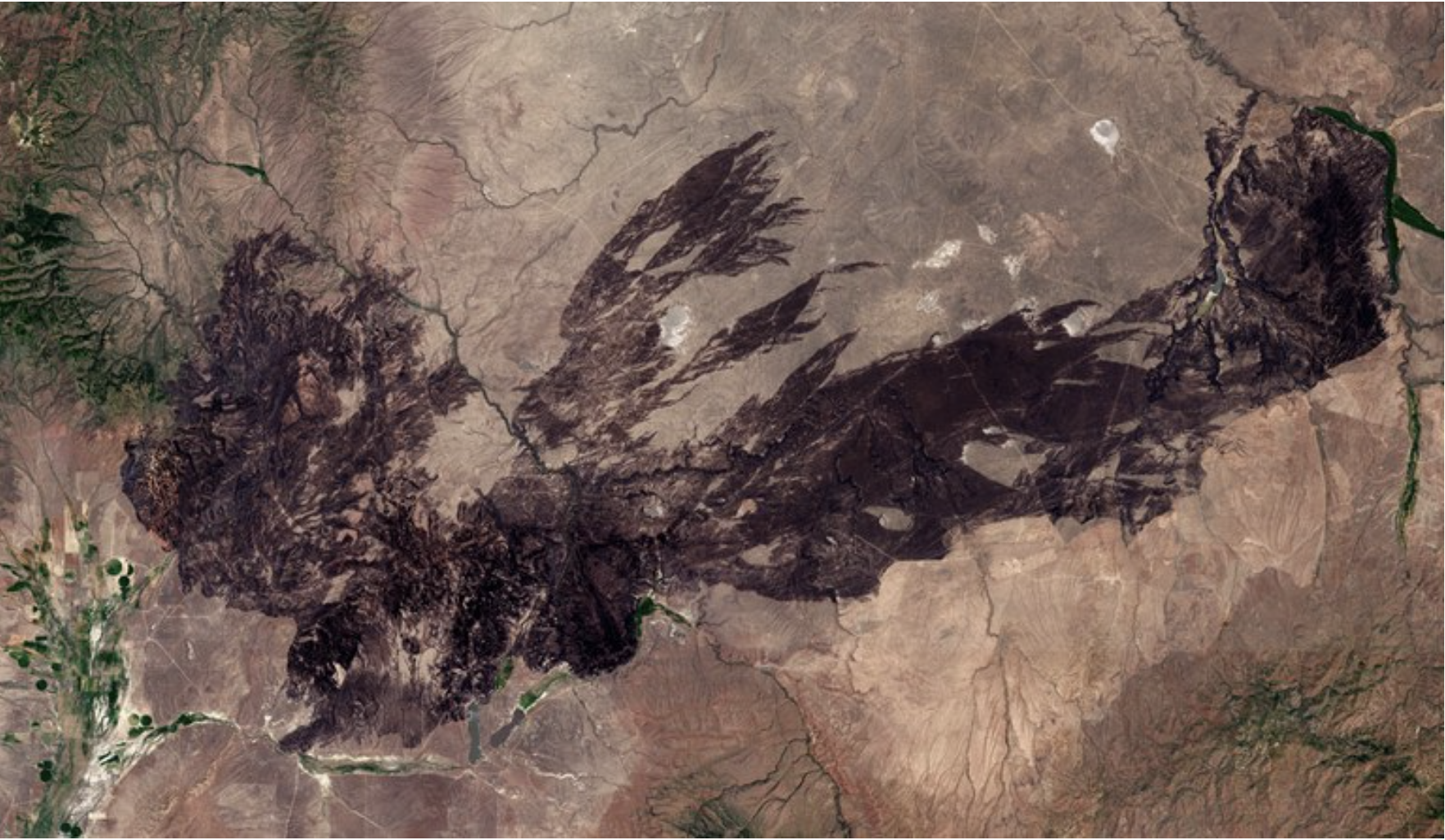
The burn scar from the Martin Fire in Nevada as seen in this aerial photo. The largest wildfire in the state’s history, it decimated sagebrush habitat. Photo credit: Pierre Markuse/CC via Flickr
Range fires get bigger every year, threatening sagebrush habitat and rural towns.
Between the town of Elko, Nevada, and the Idaho border stretches some of the most remote land in the Lower 48, rolling hills and arid basins as far as the eye can see. Last July, this section of the Owyhee Desert was scorched by a fierce, fast-moving blaze with 40-foot flames, the largest wildfire in state history. In the end, the Martin Fire burned 435,000 acres, including some of the West’s finest sagebrush habitat. Now, the raw range wind whips up the bare earth into enormous black clouds that roil on the horizon.
Once rare, fires that large, hot and destructive are now common in the Great Basin, a 200,000-square-mile region of mountains and valleys that includes all of Nevada and much of Utah, as well as parts of California, Idaho and Oregon. But despite the rising fire risk, a general lack of attention is putting the rangeland in growing danger.
The fire problem “risks permanent loss” of the ecosystem, according to Jolie Pollet, a fire ecologist and the Bureau of Land Management’s division chief for fire planning and fuels management. This is a genuine crisis, she said, and it demands greater urgency and attention than it is currently getting.
“The general public, especially urban areas, doesn’t seem to have an appreciation for the impacts on these landscapes, since the areas are so sparsely populated,” she said.
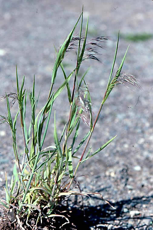
The new ferocity of rangeland fires has an old culprit: cheatgrass, an annual originally from Eurasia that was brought to this country in cattle feed, packing material and ships’ ballast in the late 1800s. It has since proliferated through overgrazing and development. The grass burns easily and often, and it thrives on fire. In intense blazes, when native shrubs perish, cheatgrass simply drops its seeds and then expands into the burned areas. The areas of greatest fire risk in the Great Basin have a high correlation with the areas of highest cheatgrass incursion, and the increasingly dry and arid climate brought by climate change is encouraging its spread. The Great Basin now has the nation’s highest wildfire risk.
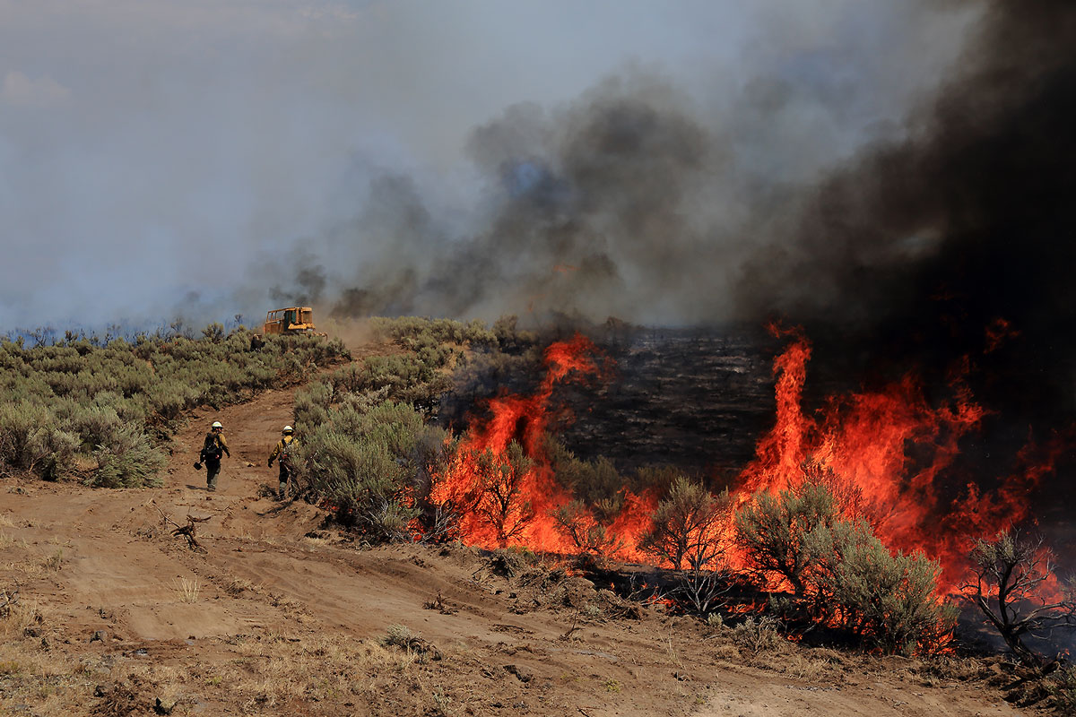
Since 2014, 9 million acres of sagebrush have been permanently lost to fires like the Artesian Fire in 2018. Photo credit: Austin Catlin/BLM
Historically, sagebrush habitat burned about once every century or less, but now it happens around every five to 10 years. Over the past two decades, more than 15 million acres of sagebrush have been permanently lost to fire, according to the BLM, 9 million of them since 2014. Overall, since 2000, more acres of shrubland or grasssland have burned than forest.
If sagebrush decline continues, the approximately 350 species that depend on it are in serious trouble. The Martin Fire burned some of the best sage grouse habitat in the country and destroyed more than 35 grouse mating grounds, or leks. The fires also harm watersheds, cause erosion and destroy wildlife corridors used by pronghorn antelope, mule deer and elk.
The impact on rural Americans is equally severe. Counties and ranchers must deal with infrastructure loss, including troughs, fencing, and damage to roads and powerlines. Many ranchers struggle with the additional costs, said Ron Cerri, a rancher and commissioner in agriculture-dependent Humboldt County, where the Martin Fire burned. Ranchers may lose hayfields in a blaze, for example, and six months of hay for 500 cattle costs about $216,000, according to Cerri. Cattle often die in the flames, and ranchers have to put down animals crippled by the smoke. Jon Griggs, a Nevada rancher whose land burned in 2007, called it the worst part of the job.
Because sagebrush ecosystems are neglected, they get less funding, making the fire threat even worse. Indeed, the BLM receives even less money than the already-underfunded Forest Service. For 2019, the Forest Service got about $400 million in annual funding for fuel management, and about $1.3 billion for firefighting preparedness. The BLM received $85 million and $180 million respectively, even though it manages about 50 million more acres of public land. The BLM also received $11 million for fire recovery, a microscopic amount, given the scale of the problem.
When the BLM runs out of firefighting money, it’s forced to raid other programs, as the blazes quickly burn through agency budgets.
“The agencies run out of money and all the other programs get gutted,” said University of Montana wildlife biology professor Dave Naugle. “In the long term, it really hurts conservation.”
Last year, Congress passed a measure that allows the BLM to access emergency fire funds without draining other initiatives. But the provision doesn’t kick in until next year, and even when it does, the BLM will remain seriously underfunded for firefighting, prevention and restoration.
Meanwhile, wildfires are already burning across the West, and the cheatgrass is beginning to dry up, turning from its spring purple to the yellowish hue that signals its readiness to burn.
Pollet put it succinctly: “I’m scared for 2019.”
Nick Bowlin is an editorial intern at High Country News. Email him at nickb@hcn.org.
Cheatgrass was introduced to North America through contaminated grain seed, straw packing material, and soil used as ballast in ships sailing from Eurasia. As a winter annual, cheatgrass seeds germinate at low fall temperatures. Seedling roots continue to grow throughout the winter, and by spring, are capable of out-competing native species for water and nutrients because most native vegetation is just getting started. Cheatgrass completes its life cycle quickly and can become dry by mid-June. Photo credit: Utah State University
Graphical representation of Colorado’s warming since 1895, from the Institute for Environmental Analytics. You can download stripes for most of the world.
SNOTEL Site via the Natural Resources Conservation Service
From the Middle Colorado Watershed Council (Erika Gibson) via The Glenwood Springs Post Independent:
Everyone is talking about snowpack this year. The news boasts epic-sounding statistics for snowpack that is “649 percent of normal,” “128 percent of average,” “440 percent of median,” or, my personal favorite, “1,776 percent of last year.” One need not speak math to know that big snowpack is generally a good thing. But unpacking the statistical lingo can help in understanding what those numbers actually indicate.
People generally understand snowpack to refer to snow depth. But in the context of water supply, snow depth doesn’t matter as much as snow-water equivalent. SWE is the amount of liquid water released when snow is melted instantaneously. SWE data mainly comes from automated sites across Colorado that capture, record and report daily data.
SWE is a more useful measurement for understanding water supply than snow depth, because water content in snow layers can vary — consider the difference between two inches of wet, heavy snow and dry powder. And when discussing snowpack, what most people care about is not cubic inches of snow in the mountains; it’s how much water will flow through our rivers, ditches and reservoirs.
This year, peak SWE for the Upper Colorado Basin was 20 inches. To add context, last year, which was dry, the SWE was 16 inches, while in the 2011 flood year it was 25 inches.
Snowpack varies throughout the year. Imagine a mountain profile where the left side is an easy, long slope that steps up to a series of peaks, and the right side is a steep, jagged descent. This is what the actual SWE data looks like plotted for each day as snowpack starts to build in October, slowly accumulates through the winter, peaks in April, then starts to melt (with some intermittent, spring-storm gains) though June or July when it’s fully depleted.
When most people bandy snowpack statistics around, they are referring to a point on that graph and “average” is probably the most confused term that gets used. We typically understand “average” to mean the arithmetic “mean,” which is the sum of numbers in a set divided by the number of numbers used in the set. (For example, the mean of 4, 6 and 20 is 10). But when discussing snowpack, the “average” typically refers to the median, which is the number that falls in the middle of the set. (So, the median of 4, 6 and 20 is 6.) In other words, there are different ways of describing what is “normal.”
Snowpack averages most often compare a relevant date of the current year to the median value on that same date within the study period (for western snowpack, the dataset is from 1981 to 2010). The median is more appropriate because it is not affected by outlier years.
You can see on an SWE graph that the median snowpack is less than the mean snowpack. This means there have been more low-snow years than high-snow years, but the high-snow years were really snowy, thus skewing the mean higher and the median lower.
Anyway, math schmath. … What most people really care about isn’t the difference between median and mean. People care about how much water there is. We want to know when the rivers will really start to flow, whether they’ll flood, and when runoff will peter out. And the relationship between snowpack and runoff has almost as much to do with the timing and intensity of spring and summer weather as the timing of peak SWE.
For example, because of spring-weather timing, runoff this year is late and expected to be sustained for longer. Peak snowpack also occurred later, and temperatures are staying cooler, so runoff is expected to peak in late June. Compare that to 2011, another heavy snow year, where warmer weather and rain caused runoff to peak in May, with more flooding.
This year’s snowpack-generated runoff is good news for water users now, but how good is it for the future? It will recharge the soil and aquifers, refill reservoirs, make for long recreation and irrigation seasons, and help mitigate Colorado’s long-term drought.
However, this region has been in a 16-year drought and needs several more years of increased snowpack and cool temperatures to alleviate the pressures on regional water supplies. According to Colorado River District engineer John Currier, we will need at least seven consecutive 2019s to fully fill lakes Powell and Mead, which are currently at historic lows.
Understanding snowpack, in sum, has more than some depth to it.
Erika Gibson is a contributor to this monthly column for the Middle Colorado Watershed Council, which works to evaluate, protect and enhance the health of the middle Colorado River watershed through the cooperative effort of watershed stakeholders: anyone standing in the watershed. To learn more about the MCWC, visit https://www.midcowatershed.org. You can also find the Council on Facebook at https://www.facebook.com/midcowatershed.
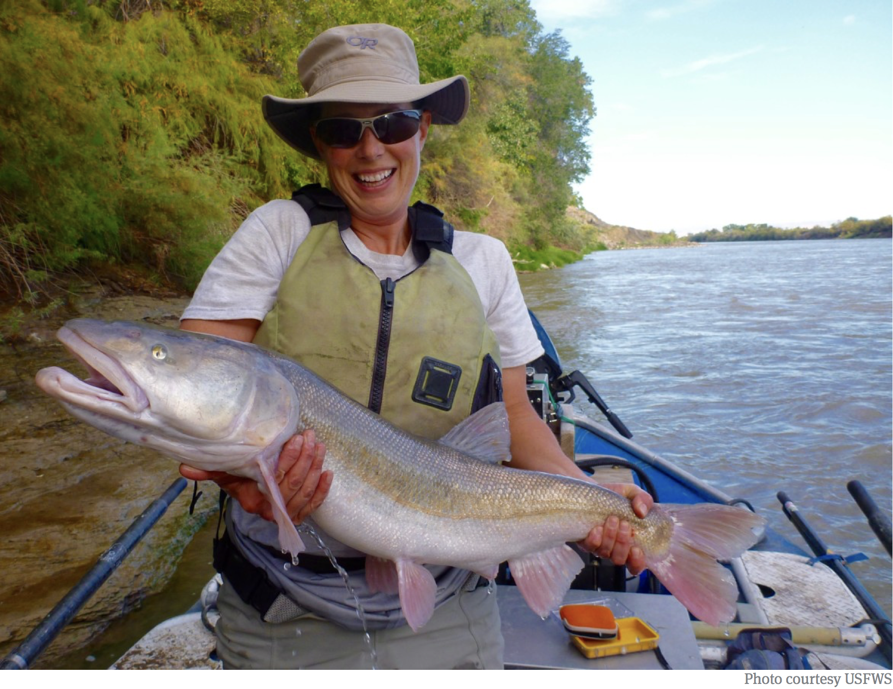
A Colorado pikeminnow taken from the Colorado River near Grand Junction, and in the arms of Danielle Tremblay, a Colorado Parks and Wildlife employee. Pikeminnows have been tracked swimming upstream for great distances to spawn in the 15-mile stretch of river between Palisade and Grand Junction. An apex predator in the Colorado, pikeminnows used to be found up to six feet long and weighing 100 pounds. Photo credit: Lori Martin, Colorado Parks and Wildlife via Aspen Journalism
The Colorado River east of Grand Junction in DeBeque Canyon is forecast to hit its annual peak Saturday, in a quick climb to about 21,000 cubic feet of water per second, as measured at the Cameo gage, before dropping over the next week as cooler weather arrives.
The operators of five upstream reservoirs have been closely watching this season’s large, and late, spring-runoff pattern, and they are now starting a coordinated release of water designed to improve habitat for endangered fish in a 15-mile stretch of the river below Palisade.
The reservoir releases, which collectively will add about 1,300 cfs of water to the river, are being timed to reach Palisade on Monday or Tuesday, after this weekend’s peak flows have subsided.
The goal of this year’s coordinated release of water is to extend the high flows, not add to the peak flow, as it is in most years, said Don Anderson, a hydrologist with U.S. Fish and Wildlife, who said care is being taken not to increase the risk of flooding this weekend.
The releases from Ruedi, Homestake, Wolford, Williams Fork and Green Mountain reservoirs are designed to benefit four ancient species of fish.
The well-timed higher water will send spawning cues to Colorado pikeminnows, large powerful fish that swim upstream to spawn in the gravel beds of what’s known as “the 15-mile reach.”
Higher water will give the recent offspring of razorback suckers a chance to find refuge in calm side channels.
Higher, faster water will scour fine silt from gravel beds, flush away dry-year vegetation growth and help the river absorb nutrients from wet floodplains.
And the high water will also benefit populations of humpback chubb downstream of Grand Junction — at Blackrocks, in Westwater canyon and near Moab — and may also help the struggling bonytail chubb.
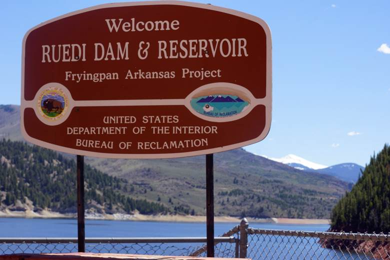
Managers of Ruedi Reservoir are participating in a voluntary release of water this week to boost flows for endangered fish near Palisade. Releases are also being coordinated from Homestake, Williams Fork, Green Mountain and Wolford reservoirs, but are being timed to come after this weekend’s peak flows. Photo credit Greg Hobbs
Ruedi releases
As part of this year’s effort, the outflow from Ruedi Reservoir into the lower Fryingpan
Reservoir will rise Sunday by 100 cfs, and over three days, the releases will climb from 354 cfs to 630 cfs or above, before stepping back down Wednesday.
The flow from Rocky Fork Creek, which runs into the Fryingpan below Ruedi Dam, was adding 75 cfs to the river Friday, which means the ’Pan could be 700 cfs or above by Tuesday or Wednesday.
Tim Miller, a hydrologist at the Bureau of Reclamation, said a flow of about 700 cfs is consistent with most of the other 10 years since 1997 that Ruedi has participated in what is called the Coordinated Reservoir Operations, or CROS, program.
Miller’s operational goals with this year’s CROS program include keeping outflow from the reservoir below inflow, so he can fill the 102,000 acre-foot reservoir in early July, while keeping flows in the lower Fryingpan below 850 cfs.
Water from Homestake Reservoir, on Homestake Creek in the Eagle River basin, will be sent this week down the Eagle to the Colorado River to benefit endangered species of fish. Half of Homestake is within Pitkin County’s boundaries, and the water is managed by Aurora and Colorado Springs. Photo credit: Brent Gardner-Smith/Aspen Journalism
Regional effort
Releases from Homestake Reservoir, which is on Homestake Creek in the Eagle River basin and is managed by Aurora and Colorado Springs, are going to climb in a similar timeframe as Ruedi’s, moving from 6 cfs to 100 cfs Monday and then stepping back down to 6 cfs by week’s end, according to a summary of the expected releases from the Colorado River Basin Forecast Center.
Releases from Green Mountain Reservoir, which is on the Blue River north of Silverthorne and managed by Reclamation, are slated to rise from 800 cfs to 1,400 cfs and then drop back down.
Releases from Williams Fork Reservoir, which is on a tributary of the Colorado east of
Kremmling and managed by Denver Water, will increase from 350 cfs to 650 cfs and then drop.
And Wolford Reservoir, on Muddy Creek north of Kremmling and managed by the Colorado River District, is currently spilling about 400 cfs of water due to high inflows. The River District regularly participates in the CROS program, but this year is spilling water in any event and not releasing water just for the CROS program as it often does.
During a series of conference calls over the past several weeks, reservoir managers have
described this year’s snowpack as “bashful” and “tentative” and “well-behaved” due to colder temperatures in May and June. And while the snow is still deep in the Colorado River’s headwaters, more cool weather is in the forecast.
And every water manager sounds glad there is at least water this year to run after last year’s deep drought, and most now expect their reservoirs to fill, which gives them flexibility this week to release water for the fish and for the river.
This year’s high flow — 21,000 cfs, forecast for Saturday — is the opposite of last year, when the Colorado peaked, as measured at the Cameo gage, on May 19 at about 6,800 cfs.
As the Animas River approaches peak flow, concerns are being raised that the city of Durango created a hazard when it added two new rapids to the Whitewater Park, resulting in many rafting companies choosing to bypass the park for safety reasons.
“It’s an unnatural hazard at the entry of the park, and it creates a rafting experience we’re not selling to our guests,” said Alex Mickel, owner of Mild to Wild Rafting & Jeep Tours. “It’s just been unfortunate.”
[…]
Since the 1980s, the city has made tweaks to the Whitewater Park, which flows alongside Santa Rita Park.
But in summer 2016, the city spent $1 million to create two new features just above the park with the sole purpose of diverting more water into the city’s water intake for municipal use.
It’s these new features that are drawing criticism and concern as the Animas River rises to higher-than-normal flows for the first time since the ledges were built. As of Friday, the river had usurped 6,000 cubic feet per second (the Animas usually peaks at around 4,700 cfs).
“They’re manmade nightmares,” said James Wilkes, co-owner of Mountain Waters Rafting. “They’re just not natural, and it’s very difficult for a raft to pass through it.”
Water and wheat — foundations of life for millennia. In the American Southwest’s arid Sonoran Desert, water flows across Arizona from more than 300 miles away to quench the thirsts of more than four million people and sustain the food, economy, and livelihoods they rely on every day. Join us as we explore the thoughts of three visionaries in Tucson who are creating and growing a circular economy of water, forging a sustainable future for a city that could have gone in another direction. And nearly did.
We hear from third-generation farmer Brian Wong, who grows a variety of low-water and heat tolerant organic heritage wheat in the arid plains northwest of Tucson, and Don Guerra of Barrio Bread, who bakes 1,000 loaves of artisanal bread per day using local and indigenous wheat varieties. Brian and Don are bound together by water and the City of Tucson’s ability to provide it to them, and their community. Lastly, we hear from Tim Thomure, director of Tucson Water — a visionary working to build and sustain a thriving city in the Sonoran Desert.
American Rivers is deeply involved with a number of efforts across Arizona to help sustain the lives of millions of people across the state, ensure the viability of a thriving economy in the desert, as well as protect the vital lifeline for the entire region, the Colorado River.
Join us as we explore these ideas, and others, across the Southwest. For more information about this work, please see our Lower Colorado River page, and follow us to keep in touch with what is going on across this important region of the country.