Click on a thumbnail graphic to view a gallery of drought data from the US Drought Monitor.


Click here to go to the US Drought Monitor website. Here’s an excerpt:
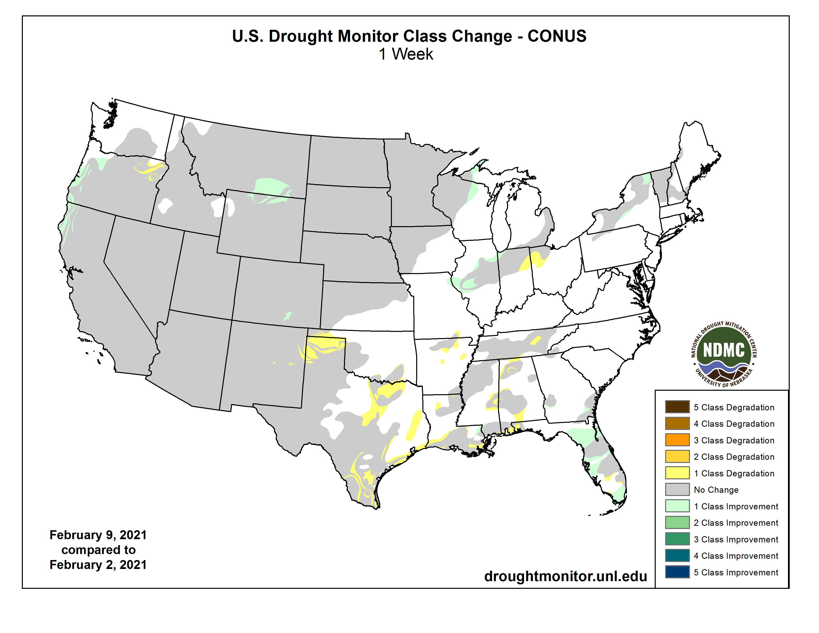
This Week’s Drought Summary
A slow-moving coastal storm delivered heavy precipitation in parts of the Northeast on January 31 – February 1, with impacts (windy weather and snow showers) lingering for several days. Later, the focus for stormy weather briefly returned to the western U.S., although significant precipitation was confined to the northern Rockies and Pacific Northwest. By February 4, wintry weather shifted into the upper Midwest, where blowing snow and gusty winds briefly resulted in blizzard conditions. The same weather system produced generally light rain across the South. Later, additional patchy precipitation fell in the central and eastern U.S., although dry weather prevailed during the drought-monitoring period across much of the nation’s southwestern quadrant. At the height of the early-February cold outbreak, temperatures plunged below -20°F across portions of the northern Plains and upper Midwest. Sub-zero readings occurred across a much larger area, extending southward across the central Plains and into the middle Mississippi Valley…
Overall, there were few changes to the High Plains’ drought depiction. Frigid weather settled across the region in early February, accompanied by periods of snow mainly in Nebraska and upslope (western) regions. Mostly dry weather persisted, however, in several areas, including northeastern Montana and the Dakotas, where lack of snow cover remained a concern with respect to lack of insulation for winter wheat during the protracted spell of sub-zero temperatures. In Glasgow, Montana, snow cover totaled an inch or less each day during the cold blast, which began with a low of 0°F on February 4 and included at least four consecutive readings below -20°F from February 7-10. In contrast, parts of Nebraska remained beneath a blanket of snow, some of which had fallen during a major storm on January 25. However, some additional snow fell in Nebraska and environs during the drought-monitoring period. For example, the weekend of February 6-7 featured Nebraska snowfall totals of 11.6 inches in North Platte, 9.6 inches in Lincoln, and 9.3 inches in Grand Island…
Aside from widespread precipitation in the Pacific Northwest and northern Rockies, the western U.S. experienced a much more tranquil drought-monitoring period. In fact, little or no precipitation fell across southern California, the Great Basin, and the Southwest, although mostly status-quo drought coverage was noted in the wake of late-January storminess. Farther north, coverage of severe to extreme drought (D2 to D3) was reduced in parts of southeastern Montana and northeastern Wyoming. Meanwhile, Oregon’s changes were mixed, with some general deterioration of conditions in the northeast and further improvement west of the Cascades. Following the late-January storminess, the California Department of Water Resources indicated that the average water equivalency of the high-elevation Sierra Nevada snowpack stood at nearly 13 inches (65% of normal for February 10), well above the January 24 value of 6 inches…
Despite a few showers, the general trend toward drier conditions continued, with some increasing coverage of abnormal dryness (D0) and moderate drought (D1) in Arkansas, Louisiana, Mississippi, and Tennessee. During the first 40 days of the year (January 1 – February 9), precipitation ranged from one-third to one-half of normal in locations such as Crossville, Tennessee (3.02 inches, or 49% of normal); Meridian, Mississippi (3.24 inches, or 46%); Lake Charles, Louisiana (2.86 inches, or 45%); Greenville, Mississippi (2.95 inches, or 43%); Jackson, Tennessee (2.25 inches, or 41%); New Iberia, Louisiana (2.57 inches, or 40%); Lafayette, Louisiana (2.78 inches, or 39%); Monroe, Louisiana (2.43 inches, or 38%); Vicksburg, Mississippi (2.37 inches, or 36%); and New Orleans, Louisiana (2.39 inches, or 35%). Short-term dryness also extended westward to coastal Texas, where some D1 was introduced between Port O’Connor and Galveston. During the first 40 days of the year, rainfall in Galveston totaled just 0.81 inch (16% of normal). Meanwhile, persistent warmth accompanied dry weather in southern Texas, resulting in growing coverage of moderate to extreme drought (D1 to D3). Drought deterioration was also noted on the High Plains, particularly in northern Texas and portions of neighboring states. According to the U.S. Department of Agriculture, statewide topsoil moisture in Texas was rated 55% very short to short on February 7, although agricultural district values were as high as 96% on the Northern High Plains (Amarillo area), 90% in the Lower Valley (Brownsville area), and 84% on the Southern High Plains (Lubbock area). In addition, 53% of Texas’ rangeland and pastures were rated in very poor to poor condition on that date, along with 31% of the winter wheat…
Looking Ahead
During the next several days, multiple storm systems will travel along or near a boundary separating warm air across the Deep South from frigid conditions farther north. Where storm-related moisture overruns cold air, there will be a significant threat of wintry weather (e.g. snow, sleet, and freezing rain), leading to potential travel disruptions and power outages. The parade of storms will produce generally light snow across the central Plains, Midwest, and Northeast, with periods of wintry precipitation expected from the southern Plains to the mid-Atlantic. Five-day Southeastern rainfall totals could reach 1 to 3 inches or more, except across the southern tip of Florida. Much of the West will also experience multiple rounds of precipitation. Each passing storm system will help to draw cold air farther southward, leading to sub-zero weekend temperatures possibly as far south as northern Texas.
The NWS 6- to 10-day outlook for February 16 – 20 calls for the likelihood of colder-than-normal conditions nationwide, except for near-normal temperatures in southern California and above-normal temperatures along the southern Atlantic Coast. Meanwhile, near- or above-normal precipitation will occur in most areas of country, with drier-than-normal weather limited to southern California, the Desert Southwest, and the north-central U.S.