@NOAA: Assessing the U.S. Climate in June 2018

Here’s the release from NOAA:

The contiguous United States had its third warmest June on record

The June contiguous U.S. temperature was 71.5°F, 3.0°F above the 20th century average. Only June 1933 and 2016 were warmer for the nation. Above-average temperatures spanned much of the Lower 48, with near- to below-average temperatures in the Northwest and Northeast. The first half of 2018 was marked by large month-to-month swings in temperature, but when averaged, the contiguous U.S. temperature was 49.4°F, 1.9°F above the 20th century average, and the 14th warmest January-June on record.

The June precipitation total for the contiguous U.S. was 3.08 inches, 0.15 inch above average, and ranked near the middle of the 124-year period of record. Much-above-average precipitation fell in parts of the Midwest, Northern to Central Plains and Mid-Atlantic with below-average precipitation across parts of the West and South. Several significant flash-flooding events impacted the U.S. during June. For the year-to-date, the precipitation total was 15.78 inches, 0.47 inch above average, and ranked near the middle of the 124-year period of record.

This monthly summary from NOAA’ s National Centers for Environmental Information is part of the suite of climate services NOAA provides to government, business, academia and the public to support informed decision-making.

June Temperature

  • Above-average June temperatures were observed for much of the nation. Seventeen states across parts of the Southwest, Great Plains, Midwest and Southeast had a much-above-average temperature. Minimum temperatures, or overnight lows, were particularly warm across the central and southeastern U.S. Iowa, New Mexico and Texas each had a record warm June minimum temperature.
  • Near- to below-average June temperatures were observed across the Northwest and Northeast. In the Northeast, a heatwave that began in late June and persisted into early July was not enough to compensate for below-average temperatures in early- and mid-June.
  • June Precipitation

    Above-average precipitation was observed in a string of states from the Northern Rockies and Plains, through the Midwest, and into the mid-Atlantic. Indiana, Iowa and Kentucky each had a June precipitation total that was much above average. During June, there were several noteworthy heavy precipitation events that caused significant regional flooding.

  • On June 15-17, heavy rainfall caused fatal flash flooding in the Upper Midwest, washing out highways, with record crests along some rivers. One of the hardest hit communities was Houghton County, Michigan, where nearly 7.0 inches of precipitation fell in a short period.
  • A slow moving low pressure system, with tropical origins, dropped record-setting rainfall along the southern Texas coast on June 18-21. A report of 11.00 inches or more of precipitation near Premont, Texas, was received by the National Weather Service. The rain gauge reached its capacity of 11.00 inches before overflowing. Widespread flooding was reported during the event.
  • On June 22, 7.61 inches of precipitation was observed in Richmond, Virginia, causing flash flooding, power outages and the closure of the Richmond International Airport. This was the second highest daily rainfall total for the city, with a period of record that dates to 1887. Of the total precipitation, 4.09 inches of rain fell in just one hour, a new hourly record for the airport.
  • Below-average precipitation was observed across parts of the West, South, Midwest, Southeast, and Northeast during June. Utah tied its sixth driest June on record, receiving just 0.07 inch of precipitation during the month, 0.66 inch below average. Some locations in the Southwest received zero precipitation during June, a frequent occurrence during this time of year.
  • According to the July 3 U.S. Drought Monitor report, 29.7 percent of the contiguous U.S. was in drought, up from 26.4 percent at the end of May. Drought conditions worsened in parts of the West, Southern Plains, the Mississippi River Valley and the Northeast. Numerous large wildfires impacted parts of the Rockies and Southwest during June, where months of warm and dry conditions contributed to an abundance of wildfire fuels. Drought conditions improved for parts of the Great Plains, Midwest and the Texas Gulf Coast. Abnormally dry conditions expanded in Hawaii and Puerto Rico.
  • Year-to-Date (January-June) Temperature

  • Above-average January-June temperatures were observed across the West, Southern Plains, East Coast and much of the Midwest. Eight states in the West and South had much-above-average year-to-date temperatures, including Arizona and New Mexico that were record warm. The Arizona statewide average temperature was 59.5°F, 4.3°F above average, and the New Mexico temperature was 53.4°F, 4.1°F above average. Near- to below-average temperatures were observed in the north-central contiguous U.S.
  • The Alaska statewide average temperature for the year-to-date was 25.6°F, 4.3°F above average, and tied 2005 as the 10th warmest on record. Above-average temperatures were observed across western and northern areas of the state, with near-average temperatures in southern Alaska.
  • Year-to-Date (January-June) Precipitation

  • Above-average precipitation was observed in the Northern Plains, Midwest and along parts of the East Coast. Seven states had a January-June precipitation total that was much above average, with record precipitation observed for some localized areas.
  • Below-average precipitation was observed for locations across the Southwest, Southern Plains, Upper Midwest and Mid-Mississippi Valley. Colorado had its 11th driest year-to-date on record.
  • Billion-Dollar Weather and Climate Disasters

  • Through the end of June, there have been six weather and climate disaster events with losses exceeding $1 billion each across the U.S. during 2018. This was double the long-term average of three events for the January-June period since 1980, but slightly less than the 7.4 event average for the January-June period of the last five years. These events included four severe storm events and two winter storm events. Overall, these events resulted in the deaths of 36 people and had significant economic effects on the areas impacted.
  • Since these records began in 1980, the U.S. has sustained 233 weather and climate disasters where overall damages/costs reached or exceeded $1 billion (including CPI adjustment to 2018). The total cost of these 233 events exceeds $1.5 trillion.
  • #Drought news: The North American Monsoon won’t save Water Year 2018

    North American Monsoon graphic via Hunter College.

    From The New Mexico Political Report (Laura Paskus):

    The arrival of the Southwest’s summer monsoons is good news—good news everyone has been waiting for, especially since a dry, warm winter hit the state hard this year.

    But drought conditions still persist in New Mexico, and despite temporary bumps in flows, the state’s rivers are still experiencing lower-than-normal flows. At the Otowi Gage on the Rio Grande in northern New Mexico—a critical point for determining how much water New Mexico must send to Texas under the Rio Grande Compact—flows dipped over the weekend to just above 700 cubic feet per second. (One cubic foot per second is equal to about 448 gallons flowing past in a minute or 7 gallons per second.) In Albuquerque, Thursday’s rainstorm pushed the river up to about normal flows. But by Saturday, the Rio Grande through the city dropped back down to about 350 cfs, about half what its flows have historically been in early July.

    And it’s not just the Rio Grande.

    On Saturday, the Animas River in Farmington was running at about 20 cfs—compared with flows that should be about 1,000 cfs this time of year. The San Juan River in Farmington saw an uptick earlier in the week, but by Saturday it had dropped down to 1,000 cfs, when it should be closer to 1,800 cfs. The Pecos River above Santa Rosa Dam is running at about seven cfs, less than a quarter of the historic norm. And in southwestern New Mexico, the Gila River near the town of Cliff—near where the state plans to build a diversion on the river—is jumping between 15 and 30 cfs. Downstream, near Red Rock, the Gila’s been running at a consistent three cfs. And while it was exciting to see the Santa Fe River roaring after Thursday’s storm, by the next day, the river was down to about six cfs.

    To see stream flow measurements statewide, visit the USGS website here

    As of late last week, the state’s largest river, the Rio Grande, was dry for about 22 miles in the San Acacia reach south of Socorro and for about four miles in the Isleta reach above Peralta…

    Meteorologists with NOAA’s Climate Prediction Center anticipate that drought will remain in the state, but that conditions will improve between now and September, thanks to monsoon rains. Even that won’t return things to normal. According to the Center for Western Weather and Water Extremes, the southwestern United States has such a precipitation deficit right now that even a historically-good monsoon won’t help the region recover enough to reach 100 percent of its normal water year precipitation.

    From The Grand Junction Daily Sentinel (Charles Ashby):

    The state’s low snowpack and lack of significant spring rains have caused several water suppliers statewide to put in place some mandatory restrictions, some of which go as far as to ban all outdoor landscape watering.

    While that hasn’t happened in the Grand Valley, water suppliers have placed the area on voluntary restrictions, meaning they are asking, but not requiring, area residents to be more judicious in how they use water.

    “(The year) 2018 has quickly become even more significant than the 2002 drought,” said Joe Burtard, external affairs manager for the Ute Water Conservancy District. “The domestic water providers along with the irrigation water providers moved Mesa County into a voluntary water restriction the earliest we’ve ever moved in, in early May of this year.”

    […]

    Burtard said the four main water suppliers in the valley — Ute Water, Clifton Water District, the city of Grand Junction and the town of Palisade — have created a Grand Valley Regional Water Conservation Plan.

    Part of that plan includes the Drought Response Information Project, a collaborative effort created by the four water suppliers after the 2002-03 drought to help instruct Grand Valley residents about water conservation.

    While that plan asks water users to voluntarily place themselves on restrictions — or at least be a little smarter about how they use water — it also comes with an agreement that if one of the water suppliers decides to make those restrictions mandatory, they all will.

    From The Albuquerque Journal (Maddy Hayden):

    A map released Thursday by the [New Mexico’s] Drought Monitoring Workgroup indicated that 87 percent of the state remains in severe or worse drought.

    That’s down from 89 percent last month, but conditions are still looking extremely dry in this part of the world.

    At the end of June 2017, that percentage was 0.

    Now, 18 percent of New Mexico – stretching from the Four Corners across much of the northern part of the state – is in exceptional drought…

    Only a small strip of land along the state’s southern border from Las Cruces eastward, making up around 1.3 percent of the state, is currently drought-free.

    Rivers around the state, including the Rio Grande, are dry or hardly flowing at some points.

    John Fleck, director of the University of New Mexico’s Water Resources Program, said the Rio Grande near Embudo north of Española was the lowest in history for Thursday’s date in more than 120 years of record keeping.

    A 22-mile stretch of the river in Socorro County is dry.

    There, the carcasses of fish litter the white sand of what should be a wet ribbon winding through the desert.

    Fleck said the the Rio Grande is still wet in Albuquerque only because of releases from the Heron, El Vado and Abiquiú reservoirs.

    “It’s not clear how much longer those supplies of stored water will last,” Fleck said.

    Depending on monsoon rains, Fleck said, the river could go dry in Albuquerque in August, which would be the first time that has happened since 1977.

    The Pecos River, too, is essentially dry above the Santa Rosa Reservoir.

    The winter’s abysmal snowpack has taken a toll on the state’s reservoirs.

    Conchas Lake was down more than 15,500 acre-feet, and Abiquiu Reservoir was down 13,000 acre-feet since the beginning of the month…

    In Albuquerque, water use has been kept under control, said Katherine Yuhas, water resources manager for the Albuquerque Bernalillo County Water Utility Authority.

    Water Utility Authority customers have used around 160 million more gallons than they had at this time last year.

    “That sounds like a lot, but that’s equal to about three-fourths of a gallon more a day,” Yuhas said.

    From The Deseret News (Amy Joi O’Donoghue):

    On Thursday, the U.S. Drought Monitor released drought details that show worsening conditions in Utah as areas already experiencing extreme or exceptional drought are continuing to grow.

    Those extremely dry conditions make the state ripe for more wildfires, the governor said, and it will likely get worse with the fireworks season looming…

    “The most severe places for drought are centered in the southeastern corner, but it is starting to spread northward,” said Shane Green, rangeland management specialist with the Natural Resources Conservation Service.

    West Drought Monitor July 3, 2018.

    Feds eye changes to a bedrock environmental law — @HighCountryNews

    Nixon Rock, in the Gunnison Gorge. Photo: Brent Gardner-Smith/Aspen Journalism

    From The High Country News (Carl Segerstrom):

    A clash over the National Environmental Policy Act follows familiar fault lines.

    A linchpin environmental law is now being scrutinized by the Trump administration and could be targeted for reforms. The National Environmental Policy Act, commonly referred to as NEPA, dictates the environmental planning process for federal agencies. Any changes to the NEPA process could have far-reaching impacts on the vast public lands and infrastructure of the West.

    The NEPA reform push broadly traces political dividing lines, as pro-business and anti-regulation Republicans, who want to see NEPA reworked, square off with environmental groups and conservation-minded Democrats hoping to preserve the law and implementation process. Caught between the vocal factions of each party are state governments and federal land managers arguing for a middle ground of limited reform.

    An August 2017 executive order, aimed at cutting environmental regulations and speeding up infrastructure projects, key goals of the Trump administration, prompted the ongoing review. The review looks at changing the implementing procedures for environmental reviews and offers some examples of what could be altered, including: limiting the time frame for environmental reviews, changing how agencies consider state and tribal input, and reducing the need to explore project alternatives.

    When federal agencies consider timber sales, build bridges, renew licenses on dams, pave highways, permit nuclear facilities or make any decision that will impact the local environment, they trigger the NEPA process. Contractors working on federal projects often commission and pay for NEPA reviews. The NEPA review process has three tiers that determine how rigorous an environmental review must be. The Categorical Exclusion designation exempts actions from environmental review if they are deemed to have no “significant effect on the human environment.” The next tier is Environmental Assessment, which compels agencies to prepare a formal review of potential impacts and decide whether the action has no significant impact or requires an Environmental Impact Statement. The Environmental Impact Statement is the most thorough review process and requires multiple drafts, a public comment period and that agencies explore alternatives to proposed projects.

    Heading the push for NEPA reform is Rep. Rob Bishop, R-Utah, who has had the law in his sights for the last decade. During a committee meeting on NEPA, Bishop, the chair of the House Committee on Natural Resources, complained the law has been warped by lawsuits and court interpretations and become “a weapon for litigants to force delays and denials on all sorts of activities.” Bishop, who has been a vocal proponent of loosening federal regulations on oil and gas companies and the transfer of federal lands to state control, said, “Environmental reviews should inform government of the actions they need to take, not paralyze it.”

    Conservation groups are digging in order to preserve NEPA and asking for an extended public commenting period on the current review. The “Protect NEPA Campaign,” which is a coalition of environmental, labor and civil rights group, such as the Sierra Club and Natural Resources Defense Council has called the Trump administration’s review an unprecedented attack on the law. More than 350 environmental organizations signed a letter to the Council on Environmental Quality, asking for an extension of the public comment period from 30 to 90 days. Raul Garcia, the senior legislative counsel for the environmental law group Earthjustice, said the month-long commenting process “is the latest in a long line of this administration’s efforts to silence public opinion and hinder democracy.”

    The Western Governors’ Association recently called for changes to the NEPA process that would give more influence to state governments. In a policy resolution, the association, which represents Western state executives, asked that federal agencies adopt more consistent NEPA planning processes and better engage with state and local governments. The group of Western lawmakers also asked that state environmental impact studies carry more weight in federal decision-making.

    Land management professionals say parts of the NEPA process could be reformed, but caution against sweeping changes to the law. Mike Ferguson, a retired Bureau Land Management land planner, first worked on NEPA implementation with the BLM in the 1970’s and has seen the implementation of the law become more convoluted over time. He says tightening the time frame for NEPA actions, clarifying the role of public comments, and investing in training and agency personnel could improve the process.

    Getting back to the basic language and intent of the law should be the goal of any NEPA reforms, says Ferguson. “A tug-of-war obliterates what NEPA was designed for in the first place, and I don’t care whether that’s from the left or the right,” he says. “Opening it up on either side will lead to a downward spiral that will dilute its effectiveness in the long-run.”

    The commenting period for NEPA reform is slated to be open through July 20, and a comment form can be accessed via the Council on Environmental Quality’s website. To date, the majority of the comments so far have either urged the council to keep NEPA intact or asked for an extended commenting period.

    Carl Segerstrom is an editorial fellow at High Country News. This article was published online on July 6, 2018.

    Fort Collins folks lower per capita water consumption

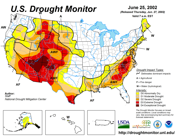
    US Drought Monitor June 25, 2002.

    From The Fort Collins Coloradoan (Nick Coltrain):

    As anyone who has watched as more and more cars stack up during the morning commute can attest, the population here keeps booming.

    But if that’s the case, why is the city’s water use continuously going down?

    Seriously. In 2000, the city of Fort Collins treated 31,594 acre-feet of water.

    In 2017, the city treated three-fourths of that, or 23,512 acre-feet — despite an additional 15,400 people tapping into the city’s water. (Fort Collins Water serves the majority of businesses and residences in the city limits, but not all.)

    […]

    People are paying attention and they’re asking about (water),” Fort Collins Water Conservation manager Liesel Hans said. “Are we going to be on restrictions this year? Is there enough water to go around? So I think people are more aware of it, for sure.”

    Hans traces the awareness back to the multi-year drought that gripped Colorado and the West starting in 2001. People, presumably in an effort to save their lawns and otherwise stave of the heat, were using on average 200-plus gallons of water per day. It was also when water conservation messages starting sprouting up in Fort Collins and statewide.

    Then, average gallon-per-capita use in Fort Collins started falling. In 2017, that measurement hit 141 gallons per capita per day, a 33 percent drop. Residential use dropped at an even greater clip: It went from 126 gallons of water per person per day to 73 — a 43 percent decline.

    That put overall water use within the city’s goal of 2020 water use. That is a moving target, however. The city has since shifted to a 2030 goal of 130 gallons per capita per day and plans to make another goal change come 2022.

    #AnimasRiver: Truck hauling sludge from the Cement Creek water treatment plant crashes and spills into Cement Creek

    From The Associated Press via The Colorado Springs Gazette:

    The driver wasn’t severely injured, but about 9 cubic yards of waste sludge spilled into the creek.

    The sludge is a byproduct of a U.S. Environmental Protection Agency treatment plant that is cleaning up water draining from the inactive Gold King mine. The EPA has said the sludge is not hazardous.

    Authorities say it doesn’t appear the truck spilled any fuel.