Pipeline from the Mississippi River to Colorado?

Mississippi River Basin

From The Pueblo Chieftain (Chris Woodka):

Hausler’s idea is to bring water from the Mississippi just below its confluence with the Ohio River across Missouri and Kansas into Colorado. The 800-mile system of pipelines, ditches and reservoirs would cost an estimated $23 billion and could provide 1 million acre-feet of water a year to Colorado. That’s just a little less than the total amount used by cities and more than enough to meet the projected municipal gap for the next 50 years.

He’s presented the idea to the Arkansas Basin Roundtable, state officials (including former Gov. Bill Ritter) and anyone else who will listen. And there’s the problem. They just listen. And maybe snicker a little. “The project is pretty dead right now,” said Hausler, a Gunnison rancher and mining engineer, in a telephone interview Monday. “I’ve gotten tired of beating my head against the wall. I think it’s silly and short-sighted, certainly parochial. Nobody in this state is really looking forward.” Hausler said the cost of construction and operation of a Mississippi River pipeline would be in line with the cost per acre-foot of proposed projects from the Colorado River…

The Mississippi River passes more than 240 million acre-feet annually at the proposed point of diversion, 30 miles south of Cairo, Ill. During the current flooding, more than 4 million acre-feet per day are flowing at that spot…

Hausler insisted the Mississippi River pipeline is a true regional solution that would not dry up any farmland or put any further stress on the Colorado River. “We need to ignore the arbitrary state lines drawn on a map in 1860s Washington and come up with a regional solution to water needs that will benefit the entire West including several Plains states,” Hausler said.

More pipeline from the Mississippi River coverage here.

Runoff news: The Yampa River is running at 10,400 cfs near Craig

A picture named yampariverbasin.jpg

From the Craig Daily Press (Andy Bockelman):

As of Tuesday afternoon, the outposts for the Yampa River in Moffat County gave readings of 10,400 cubic feet per second near Craig, 11,900 cubic feet per second near Maybell and 16,900 cubic feet per second near Deerlodge.

Aspinall Unit update: 2,600 cfs in the Black Canyon and Gunnison Gorge

A picture named blackcanyoninnercanyonnps.jpg

From email from Reclamation (Dan Crabtree):

Cool weather continues to postpone the 2011 runoff making it difficult to plan a peak operation for the Aspinall Unit. The May mid-month forecast calls for an April through July runoff of 945,000 ac-ft. with almost 1/2 (470kaf) of that forecast to occur in June. Because of the cooler weather, releases from Crystal Dam are being held at 3,500 cfs resulting in a flow in the Black Canyon and Gunnison Gorge of about 2,600 cfs. The National Weather Service 6 – 10 day weather forecast calls for equal chances of average temperatures. Consequently at this time, Reclamation is not planning any increases in release through the Memorial Day weekend. We will continue to evaluate the weather and runoff forecasts to determine the most effective timing of a peak operation designed to operate the Aspinall Unit in order to allow the Black Canyon Water Right one day peak target to be met and maximize downstream environmental benefits. This is now likely to occur sometime in early June. Please remember that changes in hydrologic conditions may require modification of these operations. (Which is to say, that as soon as we send out a notice like this, the weather changes and we have to do something different. But we wanted you all to know what we are thinking at this time anyhow).

More Aspinall Unit coverage here.

Colorado-Big Thompson Project update: 900 cfs in and out of Willow Creek Reservoir

A picture named willowcreekreservoir.jpg

From email from Reclamation (Kara Lamb):

As you have most likely noticed, releases from Willow Creek Dam have varied over the past two weeks and will continue to do so well into June. We are currently passing the inflow native to the reservoir on through the dam. This means that Northern Water is often up at the dam, adjusting the gate so the outflow matches the inflow. In the past two weeks, we have seen inflows (and as a result, outflows) get as high as 900 cfs. Today and likely over the next few days, releases will continue to be around 900 cfs. It is difficult to project what releases will be outside of a few days because of the weather forecast. It is supposed to cool off, but also rain. We will have to wait and see what that means for inflows at Willow Creek.

At Granby, we continue to release about 430 cfs.

More Colorado-Big Thompson project coverage here.

Northeastern Junior College’s Children’s Water Festival: Education is the mission

A picture named studentslesherjhsamples.jpg

From the Sterling Journal-Advocate (Callie Jones):

“We have a real big desire at the Lower South Platte (Water Conservancy District) to educate the community, and we like to start with the younger kids, about the importance of water,” said Rick Fleharty, district technician for LSPWCD, about the purpose of the Water Festival. He said they want to educate the students about the importance of water for farming and conservation for the environment. “We just have a great desire to make sure people understand how precious water is, particularly here on the plains where we don’t have an abundance of it,” Fleharty said.

More education coverage here.

Water year 2011: Possible flooding from the monster snowpack, drought over the southeastern plains and San Luis Valley

A picture named usdroughtmonitor05102011

From The Pueblo Chieftain (Chris Woodka):

State agencies have recommended to Gov. John Hickenlooper the activation of an agricultural impact task force in response to a drought that continues in 60 percent of the state. “It’s very weird to have this level of concerns about flooding and drought in the same year,” said Veva DeHeza, a Colorado Water Conservation Board staffer who co-chairs the state water availability task force…

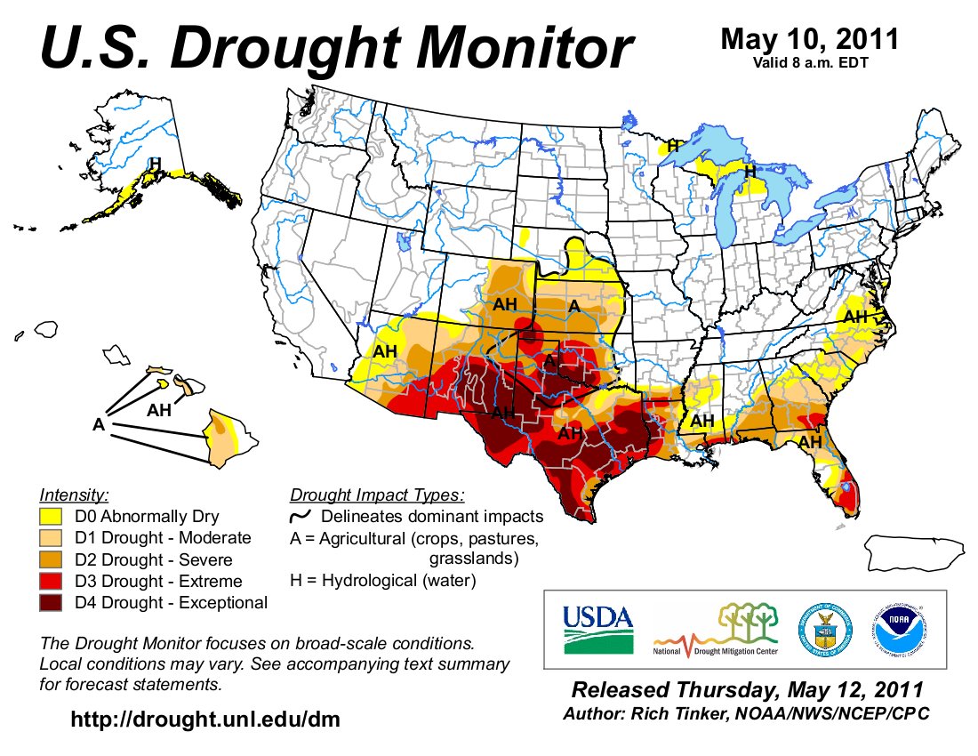
Baca County is moving into the highest level of drought, while most of the Eastern Plains south of Interstate 70 are listed in extreme drought, according to the U.S. Drought Monitor. Precipitation is only 20-70 percent of average for the year in that area, and many places have not seen appreciable rain since last summer. Baca, Cheyenne, Kiowa and Kit Carson counties have been declared disaster areas by the U.S. Department of Agriculture. Along with Bent, Las Animas and Prowers counties, they also meet triggers for federal livestock assistance.

A picture named snowpackcolorado05182011

From The Aspen Times (Scott Condon):

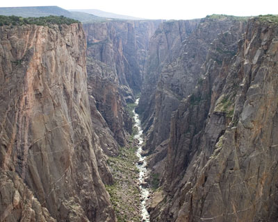
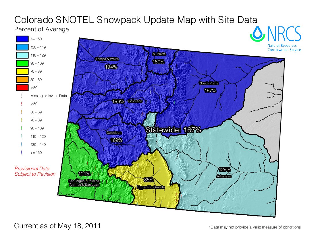
Water experts at a State of the River meeting Wednesday night in El Jebel said that the Roaring Fork, Crystal, Fryingpan and Colorado rivers all have the potential to peak at higher than average levels because the snowpack is at 200 percent of average in parts of the Roaring Fork basin. However, only minor flooding is anticipated in areas like low-lying areas along the Crystal River, said Don Meyer, senior water resources engineer with the Colorado River District. But all speakers had a caveat in their comments. Tim Miller of the U.S. Bureau of Reclamation said that computer models on streamflows assume average weather conditions during the melting period. If the temperatures spike for a considerable time, throw the models out the window, he said…

[Tim Miller of the U.S. Bureau of Reclamation] said the snowpack levels at three automated Snotel sites in the upper Fryingpan River Valley are the highest on record for mid-May. The bureau has reacted accordingly with the water level in Ruedi Reservoir…/p>

The bureau has been maintaining water releases of 360 cubic feet per second (cfs) from Ruedi into the lower Fryingpan River and will do so for the foreseeable future, Miller said. The agency projects that the reservoir will fill to a level to put the boat ramps into service by mid-June and fill to capacity by early July. Releases should be kept below 800 cfs, he said. Minor flooding can occur when releases exceed that level.

The bureau also anticipates significantly higher-than-average water diversions from the Fryingpan-Arkansas Project this year. A system of diversion structures and tunnels sends water from a multitude of creeks in the upper Fryingpan River basin east to the Front Range. The annual average diversion is 54,000 acre feet. This year, it is expected to be 94,000 acre feet, Miller said.

Lake Powell, the popular reservoir in Utah, will also benefit from the central Rocky Mountain’s bounty of snow. Current models indicate its water level will rise 44 feet, or 5 million acre feet, by July, Meyer said.

From KJCT8.com (Don Coleman):

No businesses or homes have been hit yet, but many with the county worry that that will not last. All it would take is a few hot days in the mountains to raise the Colorado River to flood level. “Emergency management is checking the river daily,” Tanny McGinnis with the Garfield County Sheriff’s Office explained…

“Really, the bigger issue isn’t so much what’s happening in Garfield County, but it’s what’s happening in Eagle County [with] the snow-pack.” Because of the high country’s deep snow-pack this year, the Colorado River is pushing thousands of cubic feet of water per second (CPS) more than it was this time last year. Authorities tell us that in Glenwood Canyon it was measured at 11,000 CPS on Wednesday compared to 7,500 CPS last year. With snow still waiting to be melted up in the mountains, that number will only increase.

From the Associated Press (Brian Skoloff) via the Anchorage Daily News:

“At this point, everybody is just sitting back chewing fingernails and waiting because the longer it stays cold and wet, the worse it’s going to get,” said Randy Julander, a supervisor with the U.S. Department of Agriculture’s Natural Resources Conservation Service. Julander said in a typical year the weather warms gradually, allowing snow in the mountains to melt slowly and ease into rivers and streams over time. That’s not the case this year.

“June is right around the corner and sooner or later, it’s going to warm up,” he said, noting that instead of gradually warming over eight to ten weeks, the West will likely see a rapid rise in temperatures heading into summer, a worst case scenario.

“And it’s not just Utah, Colorado and Wyoming. It’s basically all of the western states except Arizona and New Mexico,” Julander said. “We’re waiting for the chute to open and the bull to come out bucking, but he ain’t moving, yet.”[…]

The record snowpack levels are almost too deep to measure in some parts of northern Colorado and have officials concerned about major flooding across the state’s northern corners and down the eastern plains…

He said the last time the West saw such unusual prolonged cold weather with steady rain and snow was in 1983 when massive flooding across the region caused substantial damage. “That’s when we had terrible flooding in Utah and across the West. The Colorado River went absolutely wild for about a month,” Julander said. “The amount of water up there in the mountains is phenomenal and it’s going to melt sooner or later. You’re looking at an event that certainly only happens maybe once every 20, 30, even 50 years.”

Meanwhile, here are the presentations from last week’s Joint Water Availability and Flood Task Forces meeting from the Colorado Water Conservation Board.

More CWCB coverage here.

Arkansas Valley Super Ditch: Pilot program between the Pikes Peak Water Authority and the Caitlin Ditch planned for 2012

A picture named arkbasinditchsystem.jpg

From The Pueblo Chieftain (Chris Woodka):

A transfer of up to 500 acre-feet of water to the Pikes Peak Regional Water Authority is planned in 2012 from the Catlin Canal to demonstrate how future Super Ditch deals could work, said John Schweizer, president of both the Super Ditch and the Catlin Canal. “The Super Ditch board agreed that we should limit the scope to one ditch, because of the complexity,” Schweizer said Wednesday…

During the transfer, the number of acres equivalent to the consumptive use of the contract would have to be dried up. No water rights owners would be forced to participate. Accounting for the transfer would be handled through a state administrative plan. The Super Ditch has filed an exchange plan in Division 2 Water Court, but does not yet have a decree. No change of use application has yet been filed…

Water would be delivered to Lake Pueblo, where the city of Fountain can either use it directly through the Fountain Valley Conduit or store it…

So far, the results at controlled test plots at the Rocky Ford Agriculture Research Center show that land that has been fallowed one, two or three years still can produce more than 200 bushels of corn per acre after it is brought back into production. In terms of annual return, corn netted between $120-$640 per acre, after costs of production were factored in. Corn prices were significantly higher in 2010 than when the study began in 2007 — the price increased to $4.89/bushel from $3.29/bushel. The cost of leaving ground fallow was $100-$200 per acre, which would have to be factored as an expense into a lease agreement.

More Arkansas Valley Super Ditch coverage here and here.