Snowpack news: The South Platte River basin is dropping against average — 155%

A picture named snowpackcolorado05092011

Snowpack is declining against average in the South Platte River basin down from 156% of average since last week. Here’s the link to the South Platte Graph. The Rio Grande and southern Arkansas River basins are hurting.

A picture named snowpackcoloradobysubbasin05012011

Here’s the link to the May 1 Colorado Basin Outlook Report from the National Resources Conservation Service.

From the Delta County Independent (Hank Lohmeyer):

Rob Fiedler, emergency coordinator for the county, reported to the BoCC Monday that 100 inches of wet snow was just measured at the Trickle Park gauging station. “That’s 130 percent of average,” Fiedler said.

Colorado River Cooperative Agreement: Prior appropriation often conflicts with maintaining streamflow

A picture named coloradorivercooperativeagreementmap.jpg

From The Pueblo Chieftain (Chris Woodka):

“A change to a water right has become a suicide mission and hamstrings these types of agreements,” [Eric Kuhn, executive director of the Colorado River Conservation District] said at last week’s Interbasin Compact Committee. His comments brought a chorus of agreement, and talk of how to implement flexibility and creativity in water rights among others around the table.

Actually, the state has spent months talking with the negotiators about the kinds of things that might be acceptable in guaranteeing flows, State Engineer Dick Wolfe said this week. “We’ve looked at the agreement in order to talk about implementation,” Wolfe said. “We went through a process to identify flexibility in existing laws.”[…]

There are five separate agreements with state and federal agencies that have to be reached in order to implement the Colorado River Cooperative Agreement. State provisions include a Blue River consent decree from Division 5 Water Court in Summit County, agreement on delivery of consumptive flows from Denver in Grand County, and an agreement on environmental flows. Agreements with the Bureau of Reclamation must be reach on the Shoshone power plant and for Green Mountain Reservoir operations…

“We push to have them take it to water court,” Wolfe said. “It minimizes what a future state engineer or division engineer may decide.” While court decrees are paramount, the state engineer can administer contracts between water users, and can also shepherd state in-stream flow rights (which can only be held by the Colorado Water Conservation Board) to meet flow demands. Water court case filings serve to notify other water users if changes are being contemplated.

More Colorado River Cooperative Agreement coverage here.

Colorado Division of Wildlife: Moffat Collection System and Windy Gap Firming projects hearings recap

A picture named coloradotransmountaindiversionscu.jpg

From The Mountain Mail (Joe Stone):

Commission chairman Tim Glenn pointed out that authority of the commission is limited to review of mitigation plans to address impacts to fish and wildlife by the proposed projects.

Representatives from Grand County, Trout Unlimited, Northwest Colorado Council of Governments, Colorado River Landowners and Western Resource Advocates urged commissioners to seek more extensive measures than those proposed in mitigation plans. Specific issues during public testimony include higher water temperature, insufficient flushing flow, nutrient loading, effect of climate change, need for monitoring and adaptive management and adequacy of long-term financing…

Studies cited during testimony indicate mayfly species below Windy Gap Reservoir have been reduced from 17 species in 1983 to five species in 2010. Stonefly species have declined from 10 to four during the same time. Both insects are important food sources for trout.

Commissioners heard from the City of Broomfield and Platte River Power Authority who support mitigation proposals. They said reservoir projects would strengthen their operations…

Final recommendation from wildlife commissioners is due in June. After the wildlife commission adopts a final recommendation, the Colorado Water Conservation Board will have 60 days to affirm or modify it.

More coverage from the Associated Press via the Aurora Sentinel. From the article:

At a meeting Friday in Salida, Grand County was among those who told wildlife commissioners to better preserve stream flows so that river temperatures are cool enough for fish to thrive, and so that river systems can be flushed of sediment that can choke bugs that provide food for trout…

Both water suppliers have proposed steps such as not diverting water to their systems in the summer when stream flows drop below a certain level or when water temperatures get too high. Critics said diversions should be restricted whenever those thresholds are crossed, not just on certain dates.

More Moffat Collection System Project coverage here. More Windy Gap coverage here.

Aspinall Unit update: Flows in the Gunnison Gorge and Black Canyon should be 3,150cfs by Saturday

A picture named blackcanyoninnercanyonnps.jpg

From email from Reclamation (Dan Crabtree):

We know there is a lot of interest concerning peak flow operations on the Gunnison River this year. Reclamation would like to assure you that we are taking all flow and timing requests seriously and doing our best to weigh all issues. Timing of the peak operation is dependent on many factors including tributary flows, flooding considerations, and maximizing downstream benefits. Thanks for your patience as we watch these factors and set the timing of the peak operations. As soon as we know, you’ll know.

Flow Update – After further data analysis we found it prudent to increase releases from the Aspinall Unit to assist in accommodating the larger forecasted runoff. Consequently releases from Crystal Reservoir will be increased by 200 cfs per day through May 14th. At that time, flows in the Black Canyon and Gunnison Gorge will be about 3,150 cfs. Again, the one day peak target for the Black Canyon water right is now 6,800 cfs.

More Aspinall Unit coverage here.

Runoff news: Flood risks and drought both attributed to La Niña

A picture named cherrycreekflood08031933castlewooddamfailure.jpg

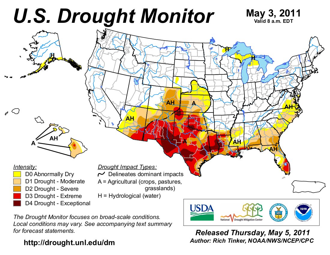
From the Associated Press (Lynn DeBruin/Catherine Tsai) via MSNBC.com:

Randy Julander, supervisor for the Utah Snow Survey, described more colorfully the disparity between the snow buried, flood endangered parts of the West and those that are parched and burning: “They’re wishing they could get a little of what we have. (The wet weather) just continues to get worse. At this point, all you can do is open the chute, let her buck and hope your butt stays glued to the saddle.” Julander was referring to the coming melt with snowpacks at 200 percent of normal or higher throughout northern Utah. One lower-elevation area in the mountains 50 miles east of Salt Lake City is at 750 percent of normal — with another big storm headed to the region early this week…

In Colorado, the city of Denver and Loveland Ski Area are separated by a mere 75 miles. Yet, the city, east of the Rockies on the high plains, has had only 21.8 inches of snow this season, the second-lowest in history with records dating back to 1882. Loveland, at the top of the Continental Divide, entered the weekend within four inches of breaking its season snowfall record of 572 inches (some 49 feet, set in 1995-1996). “It’s almost a record low for one and a record high for another. You get the idea how extreme that is,” said Kevin Houck, an engineer with the Colorado Water Conservation Board. “If I were a water manager, I’d be very happy about this.”

From 9News.com (Lori Obert):

In Grand County, emergency management officials say Lake Granby is expected to see 25 percent higher inflows this year than in years past. Grand County is offering free sandbags to its residents. Emergency management officials believe this could be the worst year of flooding since 1985.

From the Associated Press via the Aurora Sentinel:

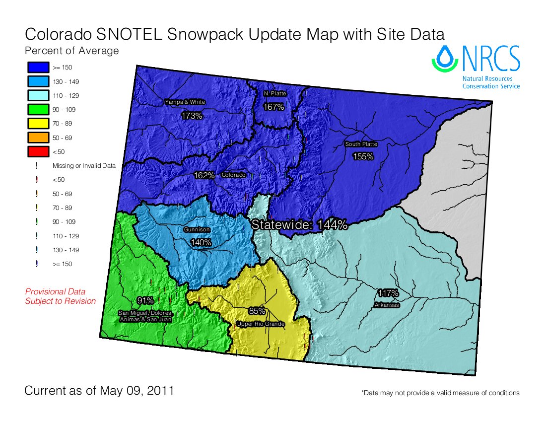
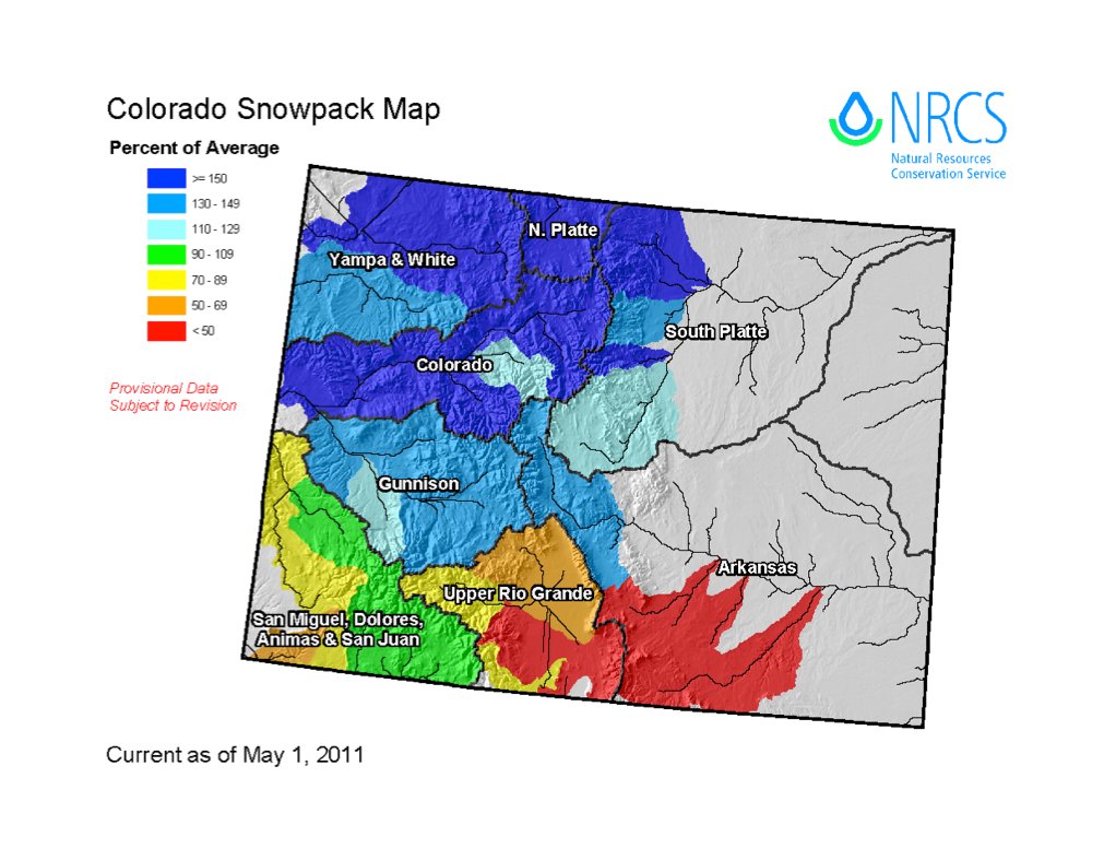
The possibility of flooding is at its highest in recent history, and federal authorities have been reporting “unbelievable” snow levels across the northern mountains, with snowpack northeast of Steamboat Springs measuring more than 200 inches deep, or about 16.6 feet…

Overall snowpack levels for the Yampa/White basins were reported at 165 percent of average. Levels northwest of Fort Collins were measured at 160 inches, or nearly 13.5 feet. In some locations, the snow was almost too deep to measure…

The Rio Grande basin measured in at only 72 percent of average. Dry vegetation, low moisture levels and high winds have sparked several wildfires in the region and national wildfire experts have been predicting a costly season in the area as they continue to struggle with drought conditions. About 180 miles east, Greeley officials have also begun to prepare for high water levels from the spring runoff. They predicted the flow rate of the Poudre River north of the city to peak at 6,000 cubic feet per second — enough to fill four Olympic size swimming pools every minute. The highest flow rate ever recorded for the Poudre river peaked at 6,610 cubic feet per second in 1999 when the river flooded its banks, caused several road closures and threatened homes.

Rio Grande River basin: The river is in trouble this year from stem to stern

A picture named usdroughtmonitor05032011

Click on the thumbnail graphic to the right and check out the Rio Grande basin. The river is in trouble this year from stem to stern. Here’s a report from Matt Hildner writing for The Pueblo Chieftain. From the article:

“It’s really in tough shape after this winter,” said Cindy Villa, a range specialist for the Natural Resources Conservation Service. While scattered portions of the valley may be in decent shape because of a high water table or exceptional weather, the majority of the 1.3 million acres of private range land is in either severe or moderate drought, according to the U.S. Drought Monitor. The National Weather Service’s monitoring station in Alamosa recorded only 10.5 inches of snowfall this winter. That total, which is 21 inches below average, ties the winter of 1999 and 2000 as the third-driest on record…

Gary Snell, who oversees the grazing programs for both federal agencies in the valley, said the main concern if conditions don’t improve would be a lack of drinking water for the herds if creeks and springs run dry at lower elevations.

From National Public Radio (John Burnett):

Standing on a sand bar spawned by the drought conditions, Texas Parks and Wildlife official Randy Blankinship points to where the Rio Grande should empty into the Gulf of Mexico — but no longer does. “It looks like the mouth of the Rio Grande is about 100 yards from the Gulf,” he says. “It comes about 100 yards short of its destination.” This is just one symptom of what is becoming the longest drought on record, surpassing even the devastating dry spell of the 1950s.

Bobby Sparks grows cotton and grain sorghum in the Rio Grande Valley, at the southern tip of Texas. When well-watered, locals brag, this soil grows the sweetest grapefruit and the juiciest melons on the planet. But seven years of drought has cost millions of dollars in crop losses, and left the farmers dispirited, Sparks says: “We’ve got people talking about retiring, talking about selling out, putting up mobile home parks… anything to generate money. They realize water is never gonna be here like it used to be.”

More Rio Grande River basin coverage here.

Uncompahgre Watershed Partnership and the Mountain Studies Institute ‘Abandoned Mines and Water Quality Conference’ recap

A picture named uncompahgrewatershed.jpg

From The Telluride Watch:

The conference, attended by over 50 community members, regional county commissioners and state and federal agency managers, and by AmeriCorps VISTA volunteers, examined varying perspectives regarding the future of mining in the county and its potential effects on water quality and on local and neighboring watersheds. Rob Runkel, of the US Geological Survey, discussed what is happening above Ouray in the historic Red Mountain Creek mining district, and Camille Price, project manager for the Colorado Department of Public Health and the Environment, discussed the history and remediation of the Idarado mine. MSI’s Chris Peltz gave a presentation on possible remediation solutions, one of them Biochar, a product made from beetle-kill lodgepole pine that is used to add carbon to damaged soil systems.

Colorado Trout Unlimited’s Snake River Project Manager Elizabeth Russell discussed Navigating Liability in Watershed Restoration, followed by a panel discussion moderated by Pat Willits of the Trust for Land Restoration. In that discussion, representatives from The Lake Fork Valley Conservancy, Animas River Stakeholders Group, Willow Creek Reclamation Committee, Kerber Creek Restoration Project, and the Coal Creek Watershed Coalition gave histories of their group’s formation, and reported on their organizations’ progress in recent years…

Interested parties can visit www.uncompahgrewatershed.org, for a Power Point Presentation, and to find out more about the organization, and to be kept apprised of upcoming meetings the UWP is organizing, concerning Total Daily Maximum Loads and about Non-Point Source Discharge Permits and how they work. The UWP and MSI would like to thank MOSAIC Community Project, Alpine Bank, Colorado Trout Unlimited and Colorado Non-Point Source Pollution Program for their financial support.

More Uncompahgre River watershed coverage here.

Ruedi Reservoir: Inspections for invasive mussels to resume later in the month

A picture named zebramusselinfestation.jpg

From The Aspen Times (Janet Urquhart):

Boaters at Ruedi Reservoir, east of Basalt, will again face weekend inspections, starting in late May, but the future of the program — an effort to prevent the spread of invasive species — is unclear. The Ruedi Water and Power Authority stepped up last year to spearhead the inspection program on summer weekends from Memorial Day through Labor Day. In 2009, inspections were infrequent — the Colorado Division of Wildlife arranged for a roving inspection unit to set up occasionally at the Ruedi boat ramp, adjacent to the Ruedi Creek campgrounds. This year, RWAPA hopes to have more people involved, in order to speed up the process of checking boats at busy times, according to Mark Fuller, the authority’s director. Inspectors are looking for zebra and quagga mussels, destructive species that have infested other Colorado reservoirs, but have not been detected in Ruedi, according to Fuller.

More invasive species coverage here and here.