Colorado Water 2012: Colorado Climate Center — CoCoRaHS for Schools

cocorahs12332011precipitation.jpg

Cruise on over to the Your Water Colorado Blog for Noah Newman’s post about the Colorado Climate Center’s ongoing effort to get a rain gauge in every classroom. Here’s an excerpt:

Besides the goal of a high density network of quality precipitation data, CoCoRaHS also has a goal of education and outreach. The most recent effort has been to train teachers and equip schools with rain gauges, having the students collect and report the data. The kick-off for ‘CoCoRaHS for Schools’ has been successful in large part due to the statewide campaign hosted by the Colorado Foundation for Water Education called ‘Colorado Water 2012′ (http://water2012.org/).

More Colorado Water 2012 coverage here.

Chevron gives up their experimental lease on the ‘Next Big Thing’ in energy — oil shale

oilshaledepositsutwyco.jpg

Oil shale has been the “Next Big Thing” in energy in Colorado for over a hundred years now. Chevron is the latest victim of the non-economic energy source. Here’s a report from the Associated Press via The Denver Post. From the article:

Chevron Corp. is giving up its experimental oil shale lease in northwest Colorado, saying it wants to free up its resources for other priorities. The company is working with the Bureau of Land Management to figure out what to do with the lease, including possibly transferring it to another company, The Grand Junction Sentinel reported Tuesday…

Chevron had been studying using carbon dioxide to draw out kerogen, a petroleum-like substance, from rock. The company said in a statement that the research was “productive.”

More oil shale coverage here.

Aurora informally approves draft oil and gas ordinance

anadarkohydraulicfracturingapril2011

From the Aurora Sentinel (Sara Castellanos):

Council members at the meeting informally approved a draft ordinance regulating oil and gas development amidst growing tensions from the community about the environmental impacts of fracking. City staff members in the coming weeks are slated to meet with major oil and gas developers to discuss the proposed draft, and council members will have to formally vote on the draft at a later date. The draft ordinance puts stricter regulations on oil and gas developers than the city’s current ordinance, but concerned residents still say council should have done more…

Aurora’s proposed regulations include requiring oil and gas companies to obtain a conditional use permit if they are considering drilling within 1,000 feet from a residential subdivision. Aurora’s current ordinance allows drilling in all zone districts. “This is a recognition that as you get closer to residential (areas) there may be impacts,” said Jim Sayre, manager of zoning and development review for the city. “There may be light, glare, traffic, vibration, noise and things we do look at with industrial activity.”[…]

The city’s draft also requires the use of best industry practices for water quality monitoring, “green” fracturing fluids and closed-loop systems. Another tenet of the draft requires traffic impact studies and haul routes…

The draft regulations would also require an emergency response plan to deal with any hazardous spills, which current ordinances do not require.

Meanwhile, Commerce City has delayed their ordinance again. Here’s a report from Bruce Finley writing for The Denver Post. From the article:

The City Council on Monday temporarily shelved a six-month moratorium on all oil and gas drilling in the city — including the controversial practice of hydraulic fracturing, or “fracking” — to allow for more talks with oil and gas interests. The council unanimously voted Monday night to hold off on a moratorium for at least 60 days while city officials continued work on an agreement that could lead to fracking regulation. Council members say the negotiations could reap broader and more effective standards than a simple ban.

More oil and gas coverage here and here.

Fort Lupton council ponies up the $75,000 annual payment for the Northern Integrated Supply Project

nisp2

From the Fort Lupton Press (Gene Sears):

Voting in the affirmative, Fort Lupton City Councilors approved the seventh in a series of payments for the Northern Integrated Supply Project Feb. 13. For 2012, the prorated portion for the city comes to $75,000, the amount necessary to retain a stake in the water supply project.

The overall 2012 price tag for NISP among all participants is $1.5 million for some 40,000 acre-feet, 3.000 of which is earmarked for the city upon completion. That amount is in addition to $10.8 million already spent by all participants on the project since inception, the majority of which centers around permitting preparations and cost.

Plagued by opposition from environmental groups such as Save The Poudre, final permitting and construction has repeatedly been pushed back until 2025 and possibly farther in the event of lawsuits, likely as the project gains ground.

While there are no guarantees that NISP will ever move past the planning stages, if the city dropped its payment schedule, any monies invested in the project thus far would be forfeited. For Fort Lupton, that total before the upcoming payment is approximately $825,000

More Northern Integrated Supply Project coverage here and here.

Colorado Water 2012: Craig Cotten — ‘Approximately one-half million acre-feet per year are pumped from the [San Luis] Valley’s aquifers to support agricultural, livestock, commercial and residential needs’

slvdischargerecharge.jpg

Here’s the latest installment in the Valley Courier’s (Craig Cotten) Colorado Water 2012 series. From the article:

Early settlers to the Valley relied on both shallow and artesian flowing wells for household and livestock use and even today, more than 90 percent of the Valley’s domestic water supply comes from wells.

But all that groundwater use does not come without an impact to the stream systems and vested water rights within the Valley.

The State Engineer is currently working on developing rules and regulations for the administration of groundwater here in the San Luis Valley to mitigate injury caused by groundwater use. This development has been going on for several years, but the story of rules and regulations actually begins in 1969. That is the year in which the Colorado legislature passed the Water Rights Determination and Administration Act. This Act, for the first time ever, gave the State Engineer the legal authority to administer wells within the priority system, which is based upon the Doctrine of Prior Appropriation. Prior to the 1969 Act, the use of groundwater was not linked to surface water rights.

The State Engineer at that time, C.J. Kuiper, wasted no time in developing rules and regulations for various parts of the state. He first developed rules for wells within the South Platte Basin, then rules for wells within the Arkansas Basin, and then he moved on to the Rio Grande Basin.

In 1975, rules and regulations were developed for wells within the San Luis Valley. These rules mandated that all large capacity wells (greater than 50 gallons per minute) were to be shut down unless they had an augmentation plan to replace their depletions. Needless to say, the SLV well owners were less than thrilled with the new rules. Many individuals and groups objected to the rules, and so, those rules were the subject of years of debate, a 12-week trial, and finally a trip to the Colorado Supreme Court.

The Supreme Court ruled that the State Engineer did have the authority to establish rules and regulations, but that there might be some better options rather than shutting all of the wells completely off. They encouraged the State Engineer to look at alternatives, specifically mentioning the Closed Basin Project. At that time, there was a belief that the Project could produce enough water to cover all of the depletions from the wells.

More Colorado Water 2012 coverage here.

Snowpack news: Storm dumps two feet of snow in the San Juans above South Fork

snowpackcolorado02272012

From The Pueblo Chieftain (Matt Hildner):

The heaviest snowfall came in the foothills above South Fork, where a spotter for the National Weather Service reported 24 inches of snow. Wolf Creek Ski Area reported 20 inches of powder from the storm, while 14 inches fell southwest of Creede, according to another weather service spotter.

From the Associated Press via The Pueblo Chieftain:

Kari Bowen of the National Weather Service in Boulder said Coal Bank Pass already recorded a foot of snow by Tuesday morning. Other parts of central Colorado have gotten a half foot.

From the Summit County Citizens Voice (Bob Berwyn):

“Our study demonstrates that the decrease in Arctic sea ice area is linked to changes in the winter Northern Hemisphere atmospheric circulation,” said Judith Curry, chair of the School of Earth and Atmospheric Sciences at Georgia Tech. “The circulation changes result in more frequent episodes of atmospheric blocking patterns, which lead to increased cold surges and snow over large parts of the northern continents.”

The researchers analyzed observational data collected between 1979 and 2010 and found that a decrease in autumn Arctic sea ice of 1 million square kilometers — the size of the surface area of Egypt — corresponded to significantly above-normal winter snow cover in large parts of the northern United States, northwestern and central Europe, and northern and central China.

The analysis revealed two major factors that could be contributing to the unusually large snowfall in recent winters — changes in atmospheric circulation and changes in atmospheric water vapor content — both linked to diminishing Arctic sea ice. Strong warming in the Arctic through the late summer and autumn appears to be enhancing the melting of sea ice.

“We think the recent snowy winters could be caused by the retreating Arctic ice altering atmospheric circulation patterns by weakening westerly winds, increasing the amplitude of the jet stream and increasing the amount of moisture in the atmosphere,” said Jiping Liu, a senior research scientist in the School of Earth and Atmospheric Sciences at Georgia Tech. “These pattern changes enhance blocking patterns that favor more frequent movement of cold air masses to middle and lower latitudes, leading to increased heavy snowfall in Europe and the Northeast and Midwest regions of the United States.”

Colorado College 2012 State of the Rockies Project: Zak Podmore — ‘Where’s the river?’

zakpodmorewillstauffernorrisstateoftherockies2012

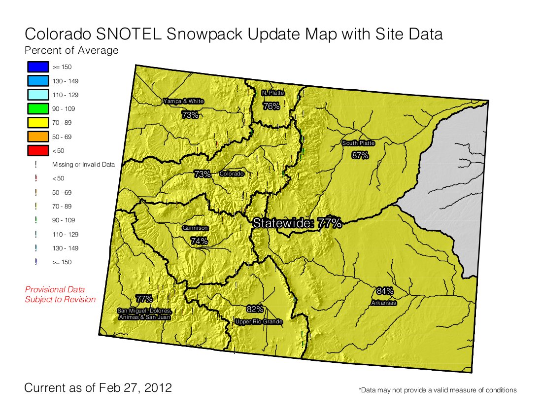
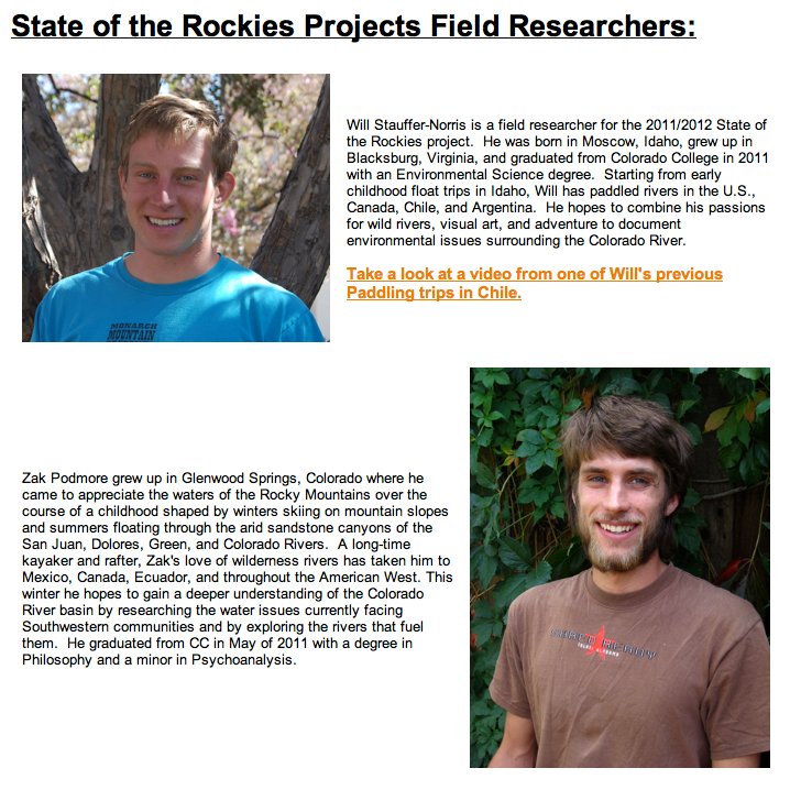
Here’s an article by Zak Podmore about the State of the Rockies Source to Sea adventure where he and Will Stauffer-Norris paddled from the headwaters of the Green River to the Colorado River Delta. Click on the thumbnail graphic to the right for short bios of both paddlers. Click through and read the whole article. Here’s an excerpt:

Over the past 108 days, we’ve paddled more than 1,600 miles down the Colorado River and its longest tributary, the Green River. Our journey is part of Colorado College’s State of the Rockies Project, an outreach research effort which this year focuses on environmental issues surrounding the Colorado River Basin…

From the time we launched until we crossed into Mexico in mid-January, asking where the river was would have been absurd. We always knew where the river was. That changed, however, when Stauffer-Norris and I, recent Colorado College graduates and field researchers for the project, reached the Mexican border. In southern Arizona, we traded our kayaks for five-pound, inflatable rafts, and paddled up to the Morales Dam, the 11th and final dam we would have to portage on the trip. There, we found a shocking sight.

On one side of the dam was the Colorado River. On the other was a trickle of water — much too shallow to float — which disappeared into the sand within a couple of miles. The mighty river that had carried us across six states and into another country had been entirely diverted out of its former riverbed 90 miles from the sea. For the next five days, we paddled through irrigation canals and pools of agricultural runoff so polluted we took pains to avoid touching it.

When the canals dried up, we attempted to follow the historical course of the river that hasn’t reached the sea since the 1998. We spent several days fighting our way through miles of invasive tamarisk and mud-cracked desert before finally reaching salt water. En route, we learned that our attempts to find the “original riverbed” were driven by a cartographer’s dream. The Colorado River once nourished more than 3,000 square miles of desert land from the Gulf of California in Mexico to the Imperial Valley in United States. The delta had no stable, narrow watercourse that could be easily converted to a blue line on a map. Instead, the river spread out into vast network of lagoons, wetlands and riparian areas, making the delta one of the most biologically diverse areas in the region.

But today, most of the delta is farmland, and the 320 remaining bird species must rely on pockets of agricultural discharge, too salty for continued use in agriculture. Before the river even reaches the Morales Dam near Yuma, Arizona, 90 percent of the water already has been diverted to the taps of cities as distant as Denver and San Diego, or converted into helping grow our wintertime supply of lettuce, carrots and other produce. At the border, the remaining water is funneled into a canal system and taken to the cities of Tijuana and Mexicali, in addition to hundreds of square miles of farms.

More Colorado River basin coverage here.

San Luis: CDPHE lifts boil order

ecoli.jpg

Chlorine, hero and villain element, saves the day again with regard to disinfection of the San Luis water system. Here’s a report from Matt Hildner writing for The Pueblo Chieftain. Here’s an excerpt:

The move allows the town’s roughly 630 residents to use their tap water, which will now be chlorinated by the San Luis Water and Sanitation District. Linda Smith, a public information officer for the emergency team handling the outbreak, said no cause was found for the contamination, nor have any illnesses related to the outbreak been reported. Public officials also left one last chore for residents, asking that anyone with appliances that dispense ice or water to replace their filters prior to using them again…

The water and sanitation district had operated under a state disinfection waiver before the outbreak, distributing untreated groundwater to residents from two wells. It decided last week to abandon the waiver and begin chlorinating the town’s water.

From the Valley Courier:

The municipal water system is currently being flushed, and residents are being instructed to start flushing the water lines in their homes by doing the following:

* Run cold water taps for five minutes.

* If you have a traditional hot water tank:

o Run your hot water until the water becomes cold.

o Turn off the hot water for about an hour, or until the water becomes warm again.

o Run the hot water a second time until it becomes cold.

* If you have an on demand hot water system:

o Run your hot water lines for a minimum of 20 minutes.

* Empty all ice trays and flush your refrigerator water lines that serve automatic ice and water dispensers.

More water treatment coverage here and here.