‘The IBCC and the nine Basin Roundtables have embarked on a scenario planning and adaptive management process’ — John Stulp

palisadepeachorchard.jpg

The IBCC report to state legislators is hot off the press. You can download a copy from the Colorado Water Conservation Board website. Here’s Director Stulp’s introduction:

I am happy to report that 2012 has been a busy and productive year for the Interbasin Compact Process. In last year’s report, we highlighted the completion of SWSI 2010 and nine basin reports. Over the course of the last year, the IBCC and the nine Basin Roundtables have embarked on a scenario planning and adaptive management process.There is general agreement that to meet the State’s future municipal and industrial demands while protecting our agricultural, environmental and recreational values, there are no easy solutions and we need to pursue all types of projects and methods to meet these needs. Four major sources of water supply have been identified as solutions for meeting Colorado’s future water demands:

 Municipal and Industrial Conservation
 Agricultural Transfers
 New Supply Development
 Implementation of Water Providers’ Projects (IPPs)

To ensure grassroots input in developing statewide solutions, each roundtable was asked to develop one or more statewide portfolios (different combinations of strategies to address future M&I demands) using the portfolio and tradeoff tool. With nearly 40 portfolios developed by the Basin Roundtables, the IBCC recognizes that we must plan for a variety of possible futures and is now considering how the various portfolios perform under 5 different scenarios. Through the process with the Roundtables and the IBCC, I have been extremely impressed with the substantive conversations that have occurred within and amongst members of the Roundtables, IBCC and others. In March, the Basin Roundtable Summit was a tremendous success where over 300 participants shared ideas and perspectives on the process. Many Roundtables are currently having meaningful conversations with other roundtables on the topic of municipal water conservation and how this important “leg of the stool” can be used to help meet Colorado’s water supply Gap.

In the near future, we will begin working closely with the Basin Roundtables to begin the development of basin plans. This effort will continue to refine each basin’s consumptive and nonconsumptive needs, available water supplies, and develop in-basin projects and methods to meet their water supply gaps. Staff is currently working with the Basin Roundtables to encourage strategic implementation of projects through the use of funding sources such as the CWCB loan program, the WSRA program, and several CWCB grant programs for nonconsumptive projects.

The CWCB is on a 6-year planning cycle for assessing Colorado’s long-term consumptive and nonconsumptive water needs with a scheduled update to SWSI in 2016. In addition, the Governor asked that a State Water Plan be developed based on scenario/portfolio work, SWSI, and the work associated with both short-term and long-term projects and methods. This effort will be a partnership between the CWCB, the IBCC, the Department of Natural Resources (DNR), the Basin Roundtables, and other stakeholders who come together as a state to collaboratively address Colorado’s water supply challenges. Key components of SWSI 2016 and the State Water Plan will include the following:

 Adoption and implementation of the SWSI 2010 recommendations work plan.
 Evaluation of the SWSI 2016 approach and methodology —including the methodology for future gap calculations —with the involvement of the CWCB, IBCC, and the Basin Roundtables
 Closing the existing consumptive and nonconsumptive water supply gaps through the implementation of both short-term and long-term projects and methods identified by the Basin Roundtables.

Another key component of SWSI 2016 and the State Water Plan will be a focus on how we can collaboratively address implementation elements that will be needed to address our future water supply needs and challenges. Using an adaptive management plan approach will allow for a flexible implementation plan that addresses future uncertainties. The scenario planning effort being led by the IBCC will be utilized to develop the adaptive management plan. The drought impacts we have seen across Colorado this year sends a strong message of how important strategic water planning is to protect our economy and citizens. This report summarizes the work and countless hours invested by staff and the citizens throughout the state that serve on the IBCC and Basin Roundtables.

watersupplyreserveaccountprojects2012.jpg

The CWCB has also released their Water Supply Reserve Account Annual Report. From the report:

Water Supply Reserve Account projects have been approved across the entire state [click on the thumbnail graphic for the map]. The WSRA Criteria and Guidelines split the Account into Basin and Statewide Funds. Each Basin Account has received $1,662,829 to date.

More IBCC — basin roundtables coverage here.

Photo of the week: Flurries along the Great Divide, double rainbow

Colorado-Big Thompson Project update: Adams Tunnel deliveries off November 5, to resume after maintenance period

firstwaterfromadamstunnel1947.jpg

From the Sky-Hi Daily News:

Maintenance season for the Colorado-Big Thompson Project begins this November, with water diversions through the Adams Tunnel stopped on Nov. 5, according to Kara Lamb, spokesperson for the Bureau of Reclamation.

“This will temporarily slow the draw on Granby Reservoir because we will not be pumping up to Shadow Mountain Reservoir and the tunnel,” Lamb wrote in an email to interested parties. “Releases from Granby to the Colorado River should remain at or above 20 cfs at the Y gauge for the rest of the calendar year.”

All annual maintenance projects scheduled for this fall on the C-BT Project on the eastern side of the Divide start to wrap up the week of Dec. 7 through Dec. 14. At that time, diversions through the Adams Tunnel are scheduled to resume.

More Colorado-Big Thompson Project coverage here.

Restoration: Contractors inspect Boston Mine erosion control project near Durango

perinspeak.jpg

From The Durango Herald (Dale Rodebaugh):

State Division of Reclamation, Mining and Safety officials on Thursday visited the site north of Twin Buttes off U.S. Highway 160 with seven potential bidders interested in restoring and revegetating 5 acres of steep hillside. The target is the Boston Mine, also known as Perin’s Peak No. 1, which operated from 1901 to 1926. The site produced more than 1 million tons of coal and left behind about 4,000 cubic yards of coal waste…

The mine is within the Perins Peak Wildlife Area, which comprises 12,000 acres of Colorado Parks and Wildlife and Bureau of Land Management holdings. The area is closed to the public Nov. 15 to July 15 as a winter haven for deer, elk, turkeys and snoozing black bears and in the spring for nesting peregrine falcons. The western half opens April 1 because no peregrines nest there…

Efforts to clean up the Boston Mine site, which at one time leaked 20 gallons a minute of toxic iron, copper, manganese and zinc into Lightner Creek, aren’t new. In 1992, grants from the Office of Surface Mining and the Bureau of Mines funded construction of wetland retention ponds to treat seepage and to assess the effectiveness of certain work.

“We stopped the leaks with the wetlands and by closing a collapsed spot that was allowing water to fill the mine workings and create seepage elsewhere,” Brown said. No seepage is seen today, she said.

The restoration will include closing a shaft, contouring a hillside, redirecting a ditch to carry runoff to one of the old retention ponds and seeding, mulching and applying 8 inches of compost and biochar – woody material reduced to charcoal through anaerobic processing – that retains a lot of water.

More restoration/reclamation coverage here.

How a Water District that Wasn’t Needed Had a Board that Wasn’t Legal & Tried to Take Half of a River for Technology that Doesn’t Exist

whiteriverwikimedia.jpg

Update: I added an article from the Grand Junction Daily Sentinel. Scroll down to the bottom.

Here’s the release from Western Resource Advocates (Jason Bane):

The Colorado Supreme Court heard oral arguments today [November 7] in a case that has significant implications for the entire State of Colorado. The Yellow Jacket Water Conservancy District (YJWCD) of Rio Blanco County is appealing a Water Court ruling that strips the district of massive amounts of water rights intended to be leased for oil shale production.

Today’s hearing comes just weeks after local residents filed a separate lawsuit alleging that the YJWCD is unlawfully taking budget action that has left the district hundreds of thousands of dollars in debt.

“This is an odd situation to say the least,” said Rob Harris, Staff Attorney for Western Resource Advocates. “We’re talking about a water district that isn’t needed, run by a board that wasn’t legal, trying to gather water rights equal to half of the White River—all to meet the theoretical demands of an oil shale technology that doesn’t exist.”

In 2009, the board of the YJWCD filed water court applications equal to almost half of the White River—with the expressed intent to lease that water for potential oil shale production. In 2011, Western Resource Advocates and a coalition of local residents, business owners, ranchers, and others (the Coalition) challenged the legality of these water rights applications. The YJWCD board voluntarily abandoned half of the contested water rights in the face of opposition, and the Coalition filed a legal challenge in regards to the other half.

“The timeline is clear, and so is the law in this case,” said Mike Sawyer, one of the attorneys representing the Coalition group. “The Yellow Jacket board didn’t have a valid board to approve new office supplies, let alone a water rights application.”

In July 2011, the Colorado Water Court stripped the YJWCD of the remaining contested water rights. Because only four of the nine seats on the YJWCD board were legally occupied in Sept. 2009, the board had no legal quorum when it filed for the contested water rights. After the Water Court denied a “Motion for Reconsideration” in Sept. 2011, the YJWCD filed an appeal to the Colorado Supreme Court.

The Colorado Supreme Court did not render a decision following today’s oral arguments, but is expected to issue a written opinion within the next several months.

On Oct. 18, two local residents and landowners filed a lawsuit against the YJWCD. Joe Livingston and Ted Edmonds are plaintiffs, which alleges (among other things) that the board has violated Colorado Budget Laws and TABOR requirements in running a debt that had reached ($142,257) by the end of 2011.

“I take great offense that the board isn’t following the law yet continues to spend my tax dollars to no end,” said Livingston, whose family has owned and operated Big Beaver Ranch near Meeker since 1941. “It’s absolutely ridiculous.”

ABOUT THE YELLOW JACKET WATER CONSERVANCY DISTRICT

The YJWCD was created in 1959 with the intent of acquiring water rights that could be leased for future oil and gas production. Most of the district’s income is from a Rio Blanco County mill levy. The YJWCD does not own or operate any water facilities—it exists solely for the purpose of acquiring water rights. Since its inception, the district has spent hundreds of thousands of taxpayer dollars trying to adjudicate water rights for the oil shale industry.

TIMELINE OF EVENTS

– Oct. 2008: Terms of office expire for four of the nine YJWCD board members.
– Sept. 2009: YJWCD submits diligence filings for certain water rights, despite the fact that only four of the nine YJWCD could authorize the filings (a fifth member of the board had resigned in Spring 2009).
– April 2011: Western Resource Advocates joins a local coalition to file a Motion for Summary Judgment, arguing that the YJWCD board did not have a legal quorum to approve a water rights application.
– July 2011: Colorado Water Court grants the Coalition’s “Motion for Summary Judgment,” and cancels the contested water rights application.
– July 2011: Yellow Jacket files “Motion for Reconsideration” with Water Court.
– Sept. 2011: Water Court denies “Motion for Reconsideration”
– March 2012: YJWCD submits appeal for hearing by Colorado Supreme Court
– Nov. 7, 2012: Colorado Supreme Court hears oral arguments from appeal.

More coverage from Bruce Finley writing for The Denver Post. Here’s an excerpt:

Colorado’s Supreme Court on Wednesday heard oral arguments by the Yellow Jacket Water Conservancy District, which is challenging a state water court’s decision rejecting its rights to 140,000 acre-feet of water from the river — water that otherwise would flow into the Green and Colorado rivers.

Yellow Jacket has proposed to build reservoirs east of Meeker to store the water and make it available to oil and gas companies. The district also is talking with towns and irrigators, Yellow Jacket attorney Sarah Klahn said after the hearing.

“There’s plenty of water in the White River,” Klahn said. “There ought to be an effort to keep water in this state, rather than letting it flow downstream to California.”

A coalition of residents whose taxes fund Yellow Jacket, a governmental district, opposes the project…

Justice Greg Hobbs questioned whether holdover status of board members could be a basis for forfeiting water property rights. Hobbs also asked why board members failed to fill positions…

The court is expected to issue a written decision in a couple months.

More coverage from Gary Harmon writing for The Grand Junction Daily Sentinel:

Colorado’s highest court is considering a challenge to the water rights held by a Meeker-area water conservancy district for eventual use in energy development.

Yellow Jacket Water Conservancy District is appealing a water court finding that canceled its right to about 140,000 acre-feet water in the upper White River Basin.

The trial court had agreed with Western Resource Advocates in a lawsuit that when Yellow Jacket filed an application to maintain its rights, the action was invalid because some members of the Yellow Jacket board of directors had yet to be reappointed.

Oral arguments were conducted on Wednesday in Denver.

The district appropriated the industrial rights in the 1960s with an eye to using them in the event oil shale development took off.

While there was always an understanding that the district, which collects $30,000 a year from property taxes, would partner with private industry to develop reservoirs.

No such arrangement, however, exists, Glenwood Springs water attorney Scott Grosscup said., adding that the district’s efforts are aimed at “establishing resources to protect the White River Basin when there is demand” for water by oil shale development.

While attorneys for the district said the suit amounted to an argument over a technicality, Western Resource Advocates attorney Rob Harris said there is more to it.

“We’re talking about a water district that isn’t needed, running a board that wasn’t legal trying to gather water rights equal to half of the White River,” Harris said, “all to meet the theoretical demands of an oil shale technology that doesn’t yet exist.”

Yellow Jacket’s attorney, Sarah Klahn, said Western Resource Advocates was “whipsawed” by precedent that allows Yellow Jacket to proceed with showing due diligence.

Companies not registered with the Secretary of State’s Office have been found to have filed valid reports with the water court, Klahn said.

“Where in Colorado water law does it say you have to have a fully appointed board as a precondition of a water- rights application?” Klahn said.

The problem of having board members sitting on the board past the end of their terms has been rectified with their reappointment by district court, Klahn said.

Appeals of water court rulings go directly to the state Supreme Court and no schedule for a ruling was set.

More water law coverage here and here.

The 2012 Oil Shale and Tar Sands Final Programmatic Environmental Impact Statement is hot off the press

colonyoilshaleproject.jpg

Click here to download a copy.

From The Grand Junction Daily Sentinel (Dennis Webb):

The Bureau of Land Management today released a final proposal to go forward with sharp reductions in land to be made potentially available for oil shale development in Colorado, Wyoming and Utah.

However, the acreage reductions are somewhat less than what were laid out in a draft proposal earlier this year.

Under the proposal, about 677,000 acres would be open for application for leasing, compared to about 2 million acres under a 2008 decision under the Bush administration.

In Colorado, about 26,000 acres would be available. About 357,000 acres would be open for leasing in Utah and 293,000 acres in Wyoming.

The total acreage in the final proposal compares to about 462,000 acres that would have been made available in the draft proposal. The BLM said in a news release that the change reflects its correction of acreage identified in the draft study as lands with wilderness characteristics in Wyoming, re-evaluation of some lands designated as areas of critical environmental concern, and refinements to management of greater sage-grouse habitat to reflect information from state wildlife agencies.

However, Colorado’s acreage would continue to be a small fraction of the 360,000 acres made available in 2008.
The final plan also carries forward the draft proposal that only research, development and demonstration leases would be issued at first. Commercial leases would be issued only when a lessee satisfies conditions including those in the RD&D lease.

The final proposal also would result in about 130,000 acres being open for commercial tar sands leasing in Utah.
The agency reconsidered its 2008 decision as part of a lawsuit settlement with conservation groups. While some conservationists and others have said the agency needs to take a go-slow approach to commercial leasing given uncertainties about technologies and impacts, counties that are home to oil shale deposits have called on the agency to keep the 2008 land allocations.

U.S. Sen. Mark Udall, D-Colo., said in a statement that he welcomes the “measured steps” the Interior Department is taking to encourage oil shale research and development.

“With water being one of our most precious commodities in the West, I have concerns about the potential impacts of commercial oil shale development. Nonetheless, I look forward to seeing this technology explored further. … The Interior Department’s decision today ensures that we will not be out over the front of our skis with untested technology .”

Also today, the Colorado BLM said it signed RD&D leases with ExxonMobil Exploration Co. and Natural Soda Holdings, Inc.

The leases, which the agency had approved in August, are for technologies the two companies are planning to test to develop oil shale in place underground in Rio Blanco County. The leases take effect Dec. 1.

More oil shale coverage here and here.

Experimental Release from Glen Canyon Dam to Benefit Grand Canyon

glencanyondam030508.jpg

Update: Here’s the release from the U.S. Bureau of Reclamation (Blake Androff/Lisa Iams):

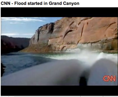
The U.S. Department of the Interior will trigger the first “high-flow experimental release” at Glen Canyon Dam since 2008 on Monday, November 19. The release is part of a new long-term protocol announced in May by Secretary of the Interior Ken Salazar to meet water and power needs, as well as to allow better conservation of sediment downstream, more targeted efforts to control non-native fish predation, and continued scientific experimentation, data collection, and monitoring to better address the important resources in the Colorado River below Glen Canyon Dam.

In cooperation with five Interior agencies, the upcoming release is designed to take full advantage of sediment deposited by Colorado River tributaries as a result of recent rainstorms and monsoons. Scientists have determined that the right conditions exist to conduct a high-flow release to benefit downstream resources, including camping beaches, sandbars, backwater habitats, riparian vegetation, and archeological sites.

The total maximum release from the dam will reach approximately 42,300 cubic-feet-per-second, consisting of 27,300 cfs of full powerplant capacity releases and a bypass release through the four river outlet tubes sending an additional 15,000 cfs of water out over the Colorado River in a spectacular visual display. The total duration of the high-flow release will be nearly five days including 24 hours at the peak release.

Click here for the current status for Lake Powell from the Bureau of Reclamation (Katrina Grantz):

Current Status
Releases from Glen Canyon Dam are currently averaging approximately 8,020 cfs with fluctuations for hydropower generation between approximately 7,000 cfs (nighttime) and 9,000 cfs (daytime). The releases in November are consistent with the Glen Canyon Operating Criteria (Federal Register, Volume 62, No. 41, March 3, 1997). The release volume for November is currently schedued as 600kaf, however, this volume may be adjusted in the event of a High Flow Experiment (see below) [ed emphasis mine].

This fall marks the first season under a multi-year High Flow Protocol announced earlier this year by Secretary Salazar. Under this Protocol, high flow releases are linked to sediment input and other resource conditions below Glen Canyon Dam. Preliminary sediment estimates appear favorable for a high flow experimental release to occur during the period of November 18 – 25, 2012 should sediment and other conditions warrant.

Reclamation’s planning activities for the high flow release are focusing on an anticipated date of November 19, 2012 for the bypass release to begin; however, no final decisions on the dates, duration or amount of the release have been made. Dam operations to ramp up to powerplant capacity prior to the bypass event would begin on November 18. During the High Flow Experiment, total releases from Glen Canyon Dam at full bypass may reach approximately 42,000 cfs. The total experiment, including ramping, could last anywhere from one and a half to six and a half days. November releases from Glen Canyon Dam prior to and after the high flow experiment would fluctuate between 5,000cfs and 8,000cfs. As more information on the potential high flow release becomes available, that information will be updated here. [ed. emphasis mine]

To view the most current reservoir elevation, content, inflow and release, click on: Lake Powell Data.

The unregulated inflow volume to Lake Powell in October was 189 thousand acre-feet (kaf) (37% of average). The release volume from Glen Canyon Dam in October was 498 kaf. The end of October elevation and storage of Lake Powell were 3619.5 feet (80.5 feet from full pool) and 13.71 maf (56.4% of full capacity). The reservoir elevation is now declining.

The water year unregulated inflow volume for 2012 was 4.91maf (45.3% of average), placing the 2012 as the third lowest on record since the closure of Glen Canyon Dam in 1963. In terms of reservoir elevation and storage, Lake Powell reached its peak for water year 2012 on June 3rd at 3636.9 ft (63.1 feet from full pool) and 15.64 maf (64.3% of capacity), respectively.

Releases for Water Year 2012 totaled 9.466 maf. Pursuant to the 2007 Interim Guidelines, Lake Powell operated under the Equalization Tier in 2012, releasing 9.463 maf, which is 8.233 maf plus 1.233 maf (the Equalization release volume from 2011 that could not be achieved by September 30, 2011). Throughout water year 2012, Reclamation adjusted operations of Glen Canyon Dam to release the appropriate annual volume during 2012 to achieve Equalization objectives as practicably as possible by September 30, 2012.

Current Dam Operations
The operating tier for 2013 is the Upper Elevation Balancing Tier, as establish in August 2012 and pursuant to the Interim Guidelines. However, if hydrologic conditions and projections become wetter, it is possible that beginning in April, the Equalization tier will govern the operations of Lake Powell for the remainder of the water year. Based on analysis of a range of inflow scenarios, the current probability of realizing an inflow volume that would trigger Equalization in 2013 is approximately 20 percent. As hydrologic conditions for Lake Powell and Lake Mead change throughout the year, Reclamation will adjust operations of Glen Canyon Dam to release the appropriate annual volume during 2013 to achieve the governing operating tier objectives as practicably as possible by September 30, 2013.

Releases from Glen Canyon Dam in November are currently averaging approximately 8,020 cfs with daily fluctuations between 7,000cfs and 9,000cfs and consistent with the Glen Canyon Operating Criteria (Federal Register, Volume 62, No. 41, March 3, 1997).

The anticipated release volume for November is 600 kaf with fluctuations for power generation throughout the day consistent with the Glen Canyon Operating Criteria (Federal Register, Volume 62, No. 41, March 3, 1997). However, the release volume may be adjusted in the event of a High Flow Experiment. This fall marks the first season of a multi-year High-Flow Protocol, under which high flow releases are linked to sediment input and other resource conditions below Glen Canyon Dam. Preliminary analysis appears favorable for a high flow experimental release to occur during the period of November 18 – 25, 2012. During the High Flow Experiment, total releases from Glen Canyon Dam at full bypass may reach approximately 42,000 cfs. The total experiment, including ramping, could last anywhere from one and a half to six and a half days. In the event of a high flow experiment, releases from Glen Canyon Dam prior to and after the high flow experiment are anticipated to fluctuate between 5,000cfs and 8,000cfs.

In December, the release volume will likely be about 800 kaf, with fluctuations throughout the day from about 8,250 cfs in the early morning to about 16,250 cfs in the early evening. In January, the release volume will likely be about 800 kaf with daily fluctuations for hydropower.

In addition to daily scheduled fluctuations for power generation, the instantaneous releases from Glen Canyon Dam may also fluctuate to provide 40 MW of system regulation. These instantaneous release adjustments stabilize the electrical generation and transmission system and translate to a range of about 1,100 cfs above or below the hourly scheduled release rate. Typically, fluctuations for system regulation are very short lived and balance out over the hour and do not have noticeable impacts on downstream river flow conditions.

Releases from Glen Canyon Dam can also fluctuate beyond scheduled fluctuations for power generation when called upon as a partner that shares reserve requirements within the electrical generator community (i.e. balancing area). To provide system reliability, all participating electricity generators within the balancing area maintain a specified level of generation capacity (i.e. reserves) that can be called upon when an unscheduled outage occurs. Glen Canyon Dam typically maintains 43 MW of reserves (approximately 1,100 cfs) for this purpose. Reserve calls can be maintained for a maximum of 2 hours after which time the generation rate should be returned to the original schedule. If reserves from Glen Canyon Dam are called upon, releases from the dam can exceed scheduled levels and can have a noticeable impact on the river downstream from Glen Canyon Dam. Calls for reserves are fairly infrequent and typically are for much less than 43 MW.

Current Inflow Forecasts and Model Projections
The hydrologic outlook forecast for water year 2013 projects that the most probable (median) unregulated inflow volume will be 7.60 maf (70% of average based on the period 1981-2010). Based on this hydrologic outlook, the October 24-Month study projects the annual release volume for water year 2013 will be 8.23 maf and the end of water year reservoir elevation and storage for Lake Powell will be 3608.52 (91.48 feet from full pool) and 12.582 maf (51.7% capacity), respectively.

If hydrologic conditions and projections become wetter, it is possible that beginning in April, the Equalization tier will govern the operations of Lake Powell for the remainder of the water year and the release volume for 2013 could be greater than 8.23 maf. Based on analysis of a range of inflow scenarios, the current probability of realizing an inflow volume that would trigger Equalization in 2013 is approximately 20 percent.

Upper Colorado River Basin Hydrology
Since water year 2005, the Upper Colorado River Basin has experienced significant year to year hydrologic variability. The unregulated inflow to Lake Powell, which is a good measure of hydrologic conditions in the Colorado River Basin, has averaged a water year volume of 10.22 maf (94% of average (period 1981-2010)) during the period from 2005 through 2012. The hydrologic variability during this period has been from a low water year unregulated inflow volume of 4.91 maf (45% of average) in water year 2012 to a high water year unregulated inflow volume of 15.97 maf (147% of average) in water year 2011. Based on observed inflows and current forecasts, water year 2013 unregulated inflow is expected to be 7.59 maf (70% of average).

Overall reservoir storage in the Colorado River Basin has increased by over 4 maf since the beginning of water year 2005 and this is an improvement over the persistent drought conditions during water years 2000 through 2004. From the beginning of water year 2005 to the beginning of water year 2013, the total reservoir storage in the Colorado River Basin increased from 29.8 maf (50% of capacity) to 33.9 maf (57 % of capacity). However, this period experienced increases and decreases in total Colorado Basin storage in response to wet and dry hydrology.

Thanks to Lake Powell Life for the heads up:

The Bureau of Reclamation will conduct a high flow experimental release of water from Lake Powell back into the Colorado River at Glen Canyon Dam mid-month, possibly between November 18th and November 25th. During the experiment, total releases from the dam at full bypass may reach 42-thousand Cubic Feet per Second. The experiment may last anywhere from a half-day to six-and-a-half days.

A BOR spokesperson says the high release flows mimic historical pre-dam spring floods and runoffs. The effects of the experimental high flow release on the downstream ecosystem of the Colorado River will be studied and analyzed. The Glen Canyon Dam Adaptive Management Program (AMP) was established in 1997 to provide for long-term research and monitoring of downstream resources. The scientific information obtained under the Adaptive Management Program is used as the basis for recommendations for dam operations and management actions.

More Colorado River Basin coverage here and here.

Piñon Ridge uranium mill hearing recap

pinonridgesite.jpg

From email from the Sheep Mountain Alliance (Hillary White):

After opening statements by all the parties kicked off the proceedings on Wed., Frank Filas, Environmental Project Manager for Energy Fuels took the stand and remained there through most of today. Mr. Filas’ testimony generally covered the entire length of the application submitted by Energy Fuels and set up the opportunity for SMA’s experts to point several deficiencies during the next few days. Matt Sandler for Rocky Mountain Wild conducted his cross examination today focused on wildlife impacts and NEPA and ESA adherence.

After Mr. Filas the focus turned to air quality impacts. Dr. Craig Little, a health physicist and radio ecologist who did the air dispersion modeling for Energy Fuels took the stand. It was a rather technical discussion and seemed to leave more questions than answers. Main questions surrounded the type of modeling used and if it could adequately address long distance impact determinations.

Next, Nancy Chick who works for the State in the Air Pollution Control Division (APCD) was called. As an aside, the APCD has been processing Energy Fuels air quality permit, a necessary part of the license for several years. The department has sent data and modeling back to Energy Fuels several times and analysis is ongoing but somewhat on hold according to the department. Ms. Chick testified to the data she has considered to date…

During the first 2 days there have been many strong comments helping SMA establish that record. We know the residents of the West End deserve good jobs and a healthy economy, but if they want a uranium mill to provide that for them we much know the cost of that mill not only to their communities but to the surrounding ones as well. Without the real costs and analysis of real impacts no one can make an informed decision.

More coverage from Gus Jarvis writing for The Telluride Watch. From the article:

Two days before the Colorado Department of Public Health and Environment began a new public hearing process over Energy Fuels, Inc.’s application for a radioactive materials license to build the proposed Piñon Ridge Uranium Mill, a group of residents who live near the Cotter Uranium Mill/superfund site in Cañon City sent a letter to Judge Richard Dana over concerns about the state’s ability to provide adequate over a new uranium mill.

The letter from the Colorado Citizens Against Toxic Waste group, a nonprofit organization, was sent to Dana on Monday. Dana is presiding over the hearing, which began in Nucla Wednesday evening.

The members of the group, who live near the Superfund site in Cañon City, stated in their letter that their concerns about the new Piñon Ridge mill stem from years of experience in dealing with CDPHE regulators on the Cotter Mill cleanup, which has been managed by the state since the late 1980s.

“Our biggest concern is that our state does not have the staff or the resources devoted to regulating a site like this, and that is where a lot of problems will come from,” the group’s co-chair Sharyn Cunningham said in a telephone interview Monday. “If the mill is built, and once they find contamination – and they will – our concern is whether or not the people living nearby will be protected by the state agencies.

“I do not believe they will be protected.”

More coverage from Heather Sackett writing for The Telluride Daily Planet. From the article:

About 25 audience members filtered into the wood-paneled room for the last hour of the hearing, which had been set aside for public comment. Placerville resident Dan Chancellor said his father’s home near Grand Junction had been built on a pile of mine tailings. At age 58, his father died of a type of lung cancer associated with radioactive materials, he said.

“Will you fail again to protect me and my family?” Chancellor asked. “There is no guarantee about jobs.”

But Ayngel Overson, a lifelong resident of Nucla, echoed a point of view held by many in the economically depressed West End. She said her grandfather was a uranium miner, and that the mill opening represents jobs in the rural area. She choked up as she described a community in decline and how graduating classes at Nucla High School have dwindled to around a dozen. She addressed her comments to those opposing the mill.

“For five years we have been waiting for jobs,” Overson told the crowd. “We can’t make it anymore … Right now, this is all they’ve got. Uranium doesn’t scare us. It’s something we’ve learned to live with. You are stopping people from surviving.”

But the aim of the four-day hearing, which continues through Monday, is not to argue the merits or dangers of the proposed mill. The purpose of the long-anticipated hearing, held at the Loyal Order of the Moose Lodge in Nucla, is for Toronto-based Energy Fuels, Inc. to supplement its application for a radioactive materials license and to give those with party status the opportunity to cross-examine the company’s representatives.

More nuclear coverage here and here.