
At @ColoLaw Martz conf, Eric Kuhn of @ColoradoWater: Im not sure were in drought; that implies a return to normal. Were in hydro uncertainty
— Josh Zaffos (@jzaffos) August 16, 2013
Day: August 16, 2013
‘We’ve seen…the worst consecutive years of inflow in the last 100 years’ — Terry Fulp #ColoradoRiver
From the Associated Press via the Albuquerque Journal:
After back-to-back driest years in a century on the Colorado River, federal water managers are giving Arizona and Nevada a 50-50 chance of having their water deliveries cut in 2016, unless the Rocky Mountains get more winter snow than in recent years. A U.S. Bureau of Reclamation operations plan being made public Friday will for the first time ever slow the flow of water from the Lake Powell reservoir upstream of the Grand Canyon to the huge Lake Mead reservoir that provides almost all of Las Vegas’ water.
But a bureau official said Lake Mead won’t reach a low point next year that would trigger cuts to Sin City’s main drinking water supply.
“What we’ve seen in the last two years are the worst consecutive years of inflow in the last 100 years,” bureau Lower Colorado Regional Director Terry Fulp said in an interview in advance of the report.
“We’re going to slow Powell’s decline. That will hasten Mead’s decline,” he said. “But next year, we can adjust again.”
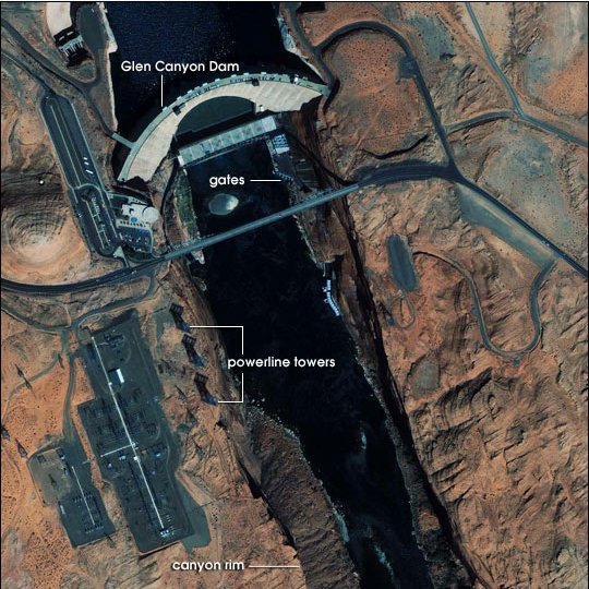
The bureau that controls the levers at the Glen Canyon and Hoover dams said cities, states, farmers and Indian tribes will get their full Colorado River water deliveries next year — and probably in 2015.
Fulp said a 2 percent chance of the Lake Mead level dropping in 2015 to the trigger point for a shortage declaration increases to 50 percent in 2016…
Fulp compares managing the two largest reservoirs on the Colorado River to pouring tea from one cup to another. He said the usual annual delivery of 8.23 million acre-feet of water from Lake Powell to Lake Mead will be cut next year to 7.48 million acre-feet. Officials say one acre-foot is enough to serve two Nevada families for a year.
Lake Powell, near the Utah-Arizona state line, would decrease from 45 percent this year to 42 percent next year.
Lake Mead, on the Nevada-Arizona state line, is currently at 47 percent capacity and could drop to 39 percent capacity next year.
Lake Mead on Thursday was at nearly 1,106 feet. The low level next year would be about 10 feet above a 1,075-foot elevation trigger point agreed upon in 2007 by the seven U.S. states that share river water under a 1928 allocation agreement. Native American tribes and Mexico also get shares of Colorado River water…
California, Colorado, Utah, New Mexico and Wyoming wouldn’t see direct cuts in their share of river water in 2016 depending on the Lake Mead water level. But officials acknowledged there would be ripple effects.
“Denver Water has a direct interest in these issues because half our supply comes from the Colorado River,” said Jim Lochhead, chief executive of the water agency serving Denver and its suburbs. “Issues like compact curtailment or political or legal confrontation along the river will affect that supply.”[…]
Utah Division of Water Resources chief Dennis Strong said his state doesn’t currently draw its full 1.4-million acre-foot allotment of river water. He said his concern was for states in the Colorado River’s lower basin.
“We’ve spent 14 years in a drought situation — with only three above-average years — and Lake Powell and Lake Mead are below half full,” Strong said. “It’s hard not to worry about the future when you’re below 50 percent.”
Governor Hickenlooper announces appointees to the Arkansas River Compact Administration

From The Pueblo Chieftain (Chris Woodka):
Colin Thompson of Holly and Scott Brazil of Pueblo have been appointed to the Arkansas River Compact Administration, along with James Eklund, the executive director of the Colorado Water Conservation Board. Appointments are made by Gov. John Hickenlooper.
Thompson, who farms on the Amity Canal, was first appointed to ARCA in 2005. His term expires in 2015.
Brazil, who farms in the Vineland area, will begin his first term on the board. He replaces Matt Heimerich of Crowley County. His term will expire in 2017.
Eklund began his CWCB post in June and replaces Jennifer Gimbel.
ARCA administers the Arkansas River Compact, which was ratified by Kansas and Colorado in 1949 to determine how the waters of the river are shared.
In recent years, ARCA has been preoccupied by issues raised by Kansas related to storage and groundwater use in Colorado. A U.S. Supreme Court case filed in 1985 was resolved in 2009.
ARCA meets annually in December.
Meanwhile, here’s a report about administering the Arkansas River this summer, from Chris Woodka writing for The Pueblo Chieftain:
Sporadic, often heavy, rains have created a “roller coaster” world of water in the Arkansas River basin this summer. “It’s been a real roller coaster the last couple of weeks,” Water Division 2 Engineer Steve Witte said Thursday.
Witte, who began issuing split calls of water rights on the Arkansas River during last year’s drought, created the first five-way call on the river this year to keep up with changed weather patterns that are dumping copious amounts of water, but only in some corners of the watershed. “The number of different calls are intended to take advantage of water where it is available,” Witte said. “It’s difficult for people to understand that with erratic conditions, there is an inconsistent supply.”
On Thursday, for instance, flows through Pueblo were at a minimum, about 100 cubic feet per second. Up around Salida, they were being maintained for rafting at about 700 cfs, thanks to releases by the Bureau of Reclamation for the voluntary flow program.
Fountain Creek was adding 345 cfs at the confluence with the Arkansas River because of rains Wednesday in Pueblo and Colorado Springs. The Purgatoire River near Las Animas was flowing at 1,400 cfs, and has reached 6,000 cfs in the past two weeks, even though it’s normally nearly dry at this time of year.
Storage also is problematic. Levels are at about 80 percent of average for August in Turquoise, Twin Lakes and Pueblo reservoirs, and extremely low at John Martin Reservoir, although some water is being stored — a rare event during the past three years. But Two Buttes Reservoir south of Lamar, under restriction since the 1965 flood, is brimming with water for the first time in decades. The state has had meetings with local residents in the past week on the best way to manage the situation.
“It’s been wild,” Witte said. “In years gone by, with conditions like this we would set a call and everyone would accept it. Now, we’re having erratic weather, coupled with increased scrutiny of the river.”