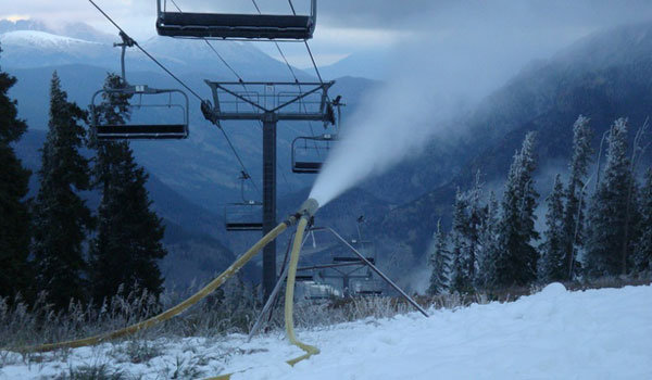
Snowmaking at Copper Mountain — Photo / ColoradoSki.com
FromThe Grand Junction Daily Sentinel (Gary Harmon):
A measure that would prohibit the U.S. Forest Service from requiring ski areas to surrender water rights for operating permits by U.S. Rep. Scott Tipton, R-Colo., garnered support from U.S. Rep. Jared Polis, a Boulder Democrat. Tipton, whose district includes most of the Western Slope and several ski areas, introduced the Water Rights Protection Act with U.S. Rep. Mark Amodei, R-Nev., in response to the requirement that was first employed with the new ownership of Powderhorn Mountain Resort near Grand Junction in 2011. Tipton hinted earlier this summer that he was preparing legislation aimed at codifying Western water rights.
The Water Rights Protection Act, or HR3189, will extend beyond ski area permits, Tipton’s office said, noting it will apply to all water rights’ holders whose rights are conferred under state law, federal or state adjudication, decrees, and interstate water compacts. The bill also would apply to conditions for transfer or relinquishment, and for any restriction or impairment of water rights made for the benefit of the federal government, Tipton’s office said.
In the Powderhorn case, new ownership was required to sign over water rights issued under state law in order to obtain the Forest Service permit to operate the resort.
The National Ski Areas Association based in Lakewood filed suit and a federal judge ordered the Forest Service to comply with federal law requiring public comment on such significant changes in policy. No new policy has been made public.
The Forest Service said the policy was necessary to prevent ski areas from selling off their water rights for other purposes, a practice that Tipton noted in a statement on the bill had never happened. Ski areas use their water rights for snowmaking.
The measure would preserve state water law that is “being undermined by federal intrusion that creates uncertainty and jeopardizes the livelihoods of communities, individuals, and businesses responsible for thousands of jobs,” Tipton said in a statement. “To undermine this system is to create risk and uncertainty for all Western water users.”
Western Slope advocacy organization Club 20 supports Tipton’s efforts. “Club 20 policy does not support the Forest Service ski area water rights clause and supports Congressman Tipton’s efforts to keep the (Forest Service) from requiring that ski areas turn their water rights over to the federal government,” Club 20 Executive Director Bonnie Peterson wrote in an email. “Should this practice be allowed, Club 20 members are concerned that the federal government would extend its reach to take ownership of water associated with other uses, like grazing and municipal water rights from those that have legitimately developed and own those rights.
“Water is a state issue and state water laws currently protect the use of those developed water rights adequately,” Peterson wrote.
A $2 million project to replace corroded water supply pipes in Lamar got its final piece of funding last week from the Colorado Water Conservation Board. The board approved a $785,000 loan and a $200,000 grant for the project, which will be matched by a $985,000 grant from the Department of Local Affairs. The Arkansas Basin Roundtable gave its nod to the project in June.
The project is needed because of heavy corrosion and leakage in the pipes that bring water from wells to the city. Water from two separate well fields is high in dissolved solids, and must be blended in order to use it. It also will upgrade parts of the water system in anticipation of completion of the Arkansas Valley Conduit, which is several years down the road.
It’s estimated that Lamar water customers would pay an additional $1.07 per month to repay the state loan.
The fate of a proposed nuclear power plant — the first in Utah — turns on the ebb and flow of the Green River, where proponents of the project want to divert water to cool the plant’s nuclear reactors.
For five days in a small courtroom in Price last week, Judge George Harmond — who once served on the Utah Board of Water Resources — listened to reasons why the decision to grant that water for the plant was within the law or, alternately, why it contravened the statute governing water allocations.
Ultimately, whatever the 7th District judge decides — he took the case under advisement and will issue a decision within 60 days — the loser in this contest is destined to appeal.
I wonder what is different in the new designs that makes them require less water than Fukushima Daiichi did. It seems to me that it requires unlimited volumes of water when you are fighting for control of a fission reaction. That sort of supply is not apparent in the landscape near the reactor site.
FromThe Grand Junction Daily Sentinel (Dennis Webb):
Some companies pursuing oil shale projects in Colorado and Utah voiced confidence in their efforts Wednesday even as they absorbed the news that Shell is shutting down its undertaking in Rio Blanco County.
Among them is American Shale Oil LLC, which holds a federal research, development and demonstration lease in Rio Blanco County and is working to develop oil shale in-situ, meaning in place underground. “AMSO’s still committed to its project. We still believe (oil shale) is a viable resource using our approach” to develop it, said Claude Pupkin, chief executive officer of Genie Energy, which owns a 50 percent interest in AMSO.
In northeastern Utah, Red Leaf Resources continues to move “full-speed ahead” with its project, with the next goal being a commercial demonstration of its surface-mining and processing approach to develop oil shale, said CEO Adolph Lechtenberger.
“Everything we look at in our technology says it’s certainly economic at today’s oil prices,” he said.
Shell said this week it is ending its in-situ Colorado oil shale project, which it began in 1996. Shell has been a leader in oil shale research in the region and owns three federal RD&D leases in Rio Blanco County. Shell said it had decided to focus on other opportunities and assets in its global energy portfolio, including oil shale projects in Jordan and Canada.
Last year, Chevron, which also holds a federal RD&D lease in Rio Blanco County, also said it was ending its oil shale project.
ExxonMobil, which recently was granted a federal RD&D lease in Rio Blanco County for an in-situ project, declined to react to Shell’s decision, saying it doesn’t comment on the activities of other companies. But spokesman Patrick McGinn said it is continuing lab-based work on its process.
Different barrel of oil
ExxonMobil is hoping to fracture shale, fill fractures with conductive material and then heat the shale with an electric charge to produce oil. “We are concentrating our efforts on developing additional improvements in thermal and electrical process efficiency to further improve the economic and environmental factors of any commercial development.
“Field experiments to test new developments could be conducted at either (the company’s Parachute-area) Colony Mine or the ExxonMobil RD&D lease in Rio Blanco County. We do not anticipate field tests in 2013,” he said by email.
Lechtenberger said it’s unfortunate to see a player of Shell’s size pull out of Colorado. “They’ve done a lot of good work over the years and made pretty good strides,” he said.
But he added, “I think we’re going after a different barrel of oil than Shell was going after.” Shell was targeting shale deep underground, he noted.
“Our technology is going after shale closer to the surface, easier to mine, with a lower cost to remove,” he said.
Enefit also is working on a surface shale project in Utah. Lechtenberger said he thinks the deeper-shale projects in Colorado “are going to be a challenge. I think they’re going to be capital-intensive and they’re going to take good technology to do it.”
Companies pursuing the in-situ process in Colorado are targeting the heart of what is the world’s largest oil shale resource and extends into Utah and Wyoming. They also say their approach will result in fewer surface impacts.
AMSO has been working through some challenges with heaters for its project and is currently evaluating alternative heaters it can use.
Pupkin said it’s important to note that Shell isn’t pulling out of oil shale altogether. “They have a very active project ongoing in Jordan and our understanding is that it’s because Jordan not only has very attractive oil shale but they’ve put in place a regulatory framework that makes investment projects capital-attractive,” he said.
Regulatory uncertainty
Jeremy Boak, director of the Center for Oil Shale Technology and Research at the Colorado School of Mines, said the last he heard Shell has more than 200 people working on oil shale in Jordan. Worldwide, it has spent hundreds of millions of dollars on oil shale, he said. “They’re clearly not abandoning oil shale as a concept. They’re just deciding that Colorado is not the place they want to do it right now even though it’s (home to) the world-class resource.”
Pupkin said he thinks the regulatory uncertainty related to the Bureau of Land Management’s changing position regarding royalties and other oil shale rules contributed to Shell’s decision. Shell has voiced concern over that uncertainty in the past but didn’t specifically cite it this week.
The BLM also has sharply reduced the amount of land potentially available for oil shale leasing in the three-state region, and particularly in Colorado. “We think that the Obama administration has taken a pretty negative approach towards oil shale,” Pupkin said.
Jeff Hartley of Red Leaf Resources noted that his company doesn’t face the constraints Shell faced with BLM lands because it is working on school trust lands instead.
Viable technologies
Chevron spokeswoman Cary Baird said she doesn’t believe her company raised regulatory concerns as an issue when it made its oil shale decision. Rather, it was just a matter of prioritizing what opportunities to invest financial and human resources in at a global level, she said, somewhat echoing Shell’s reasoning. “There are difficulties occasionally in getting good, qualified people to work on different projects and when you have a global portfolio it makes it more complicated,” she said.
Shell’s decision comes as companies are using hydraulic fracturing to produce growing amounts of natural gas and oil. Shell just this week identified a location for a $12.5 billion natural-gas-to-liquids facility it hopes to build in Louisiana.
“When you compare the challenge of oil shale to the viability of these other sources, Shell like Chevron decided to place their focus on viable technologies and viable business models,” said David Abelson, oil shale policy advisor for the Western Resource Advocates conservation group. He said he wasn’t surprised by Shell’s announcement, and that it’s learned what other companies have learned over a century about the “extremely challenging” economics of developing oil shale.
“Shell has always said that this is a research project and they always talked about it being a heavy lift to create a viable fuel and what they learned is what Chevron learned,” he said.
He said Shell hasn’t been among the strongest boosters of oil shale. “It was the elected officials that got ahead of Shell and claimed the viability of these technologies,” he said.
From email from the Middle Colorado Watershed Council:
The Middle Colorado Watershed Council is excited to host an informational workshop [September 24] that will explore the opportunities for information exchange and integration between several important and timely water resource planning efforts currently underway. The afternoon’s panelists will include:
Jim Pokrandt, Communication and Education Specialist with the Colorado River District and Chair of the Colorado Basin Roundtable;
Louis Meyer, President and CEO of SGM Inc., Garfield County’s representative on the Colorado Roundtable, and Consultant to the Roundtable for development of the Basin Plan; and
Ken Neubecker, Executive Director of the Western Rivers Institute and the Environmental Representative on the Colorado Basin Roundtable
Topics the speakers will cover include:
History of the Roundtable and its function
What the Statewide Water Plan intends to accomplish and how it will use information generated through the Roundtable process
Findings of the Roundtable analyses specific to the Middle Colorado River
Projects identified to date and opportunities for generating new projects
Opportunities for information exchange, integration and collaboration between watershed-based, regional and statewide water resource planning efforts
The presentations will be followed by an open forum providing opportunity for Q&A as well as public input and feedback.
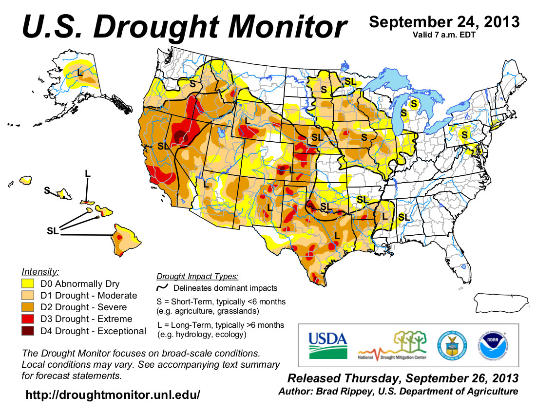
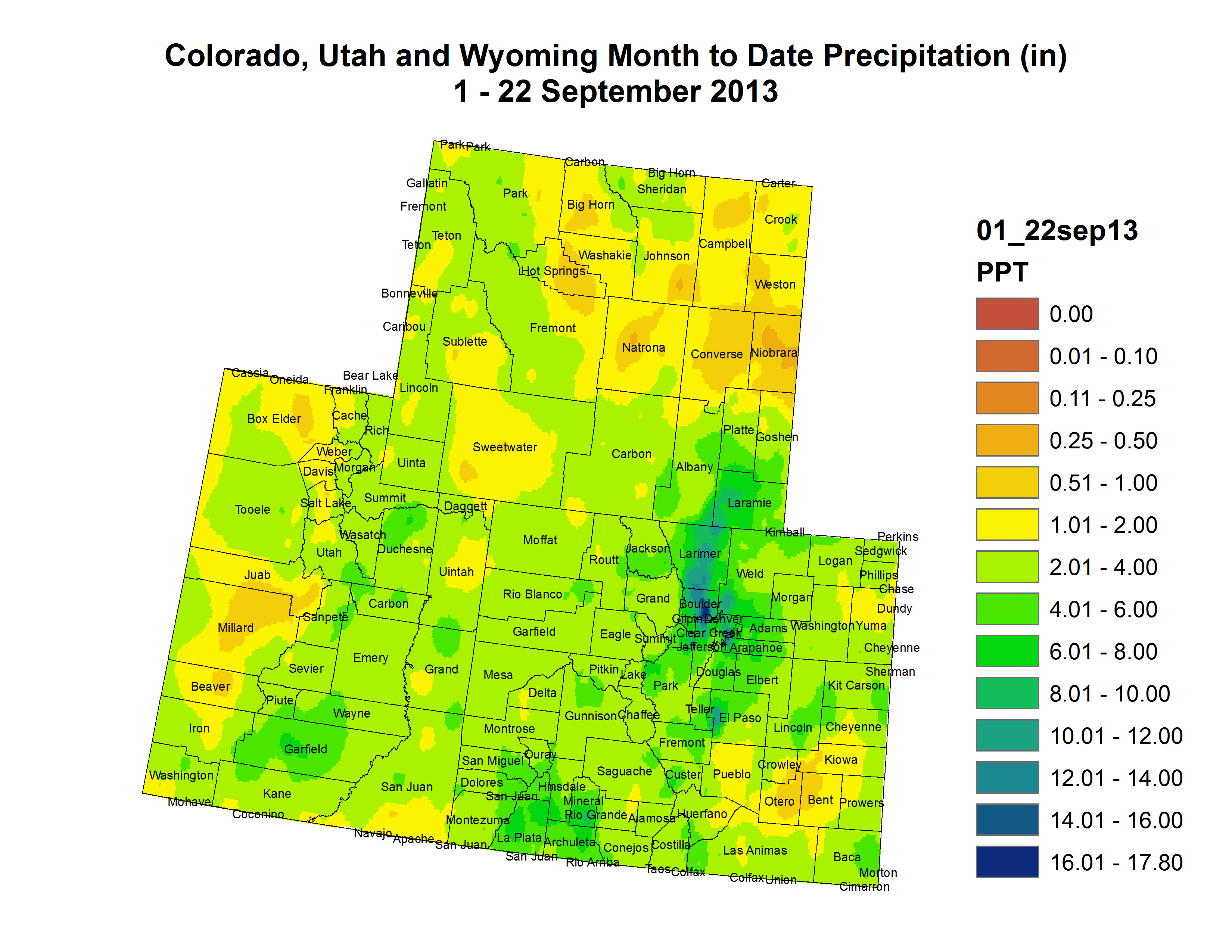
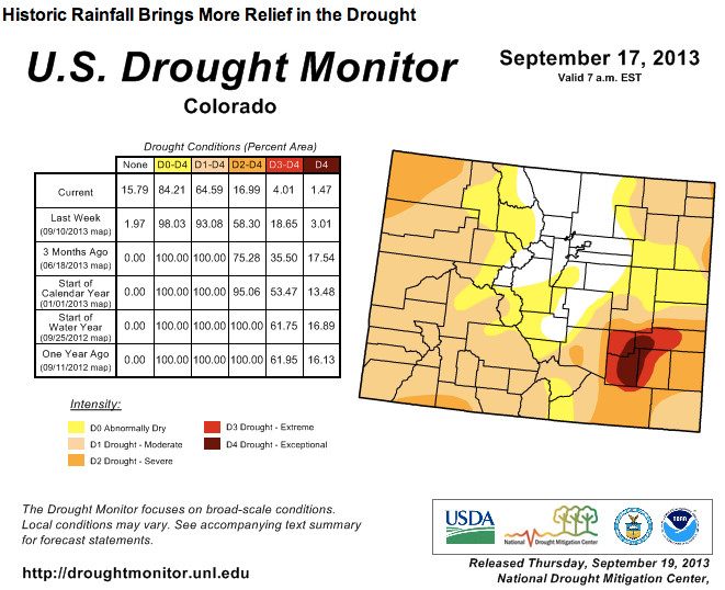
From the US Drought Monitor discussion September 24, 2013:
Weather Summary: Rain lingered in parts of Colorado and neighboring states for a few days in the wake of historic flooding, but mostly dry weather thereafter allowed recovery efforts to progress. However, a flood crest on the South Platte River coursed through northeastern Colorado and southwestern Nebraska, inundating some agricultural lowlands. Meanwhile, the tropical plume of moisture partially responsible for Colorado’s flooding shifted eastward in advance of a cold front. As a result, 1- to 3-inch rainfall totals were common along and east of a Wisconsin-to-Texas line. The rain temporarily halted fieldwork, including harvest activities and winter wheat planting, but aided some late-developing summer crops. Even heavier rain, locally 4 inches or more, curtailed fieldwork but eased drought from central and eastern Texas to the Mississippi Delta. Elsewhere, generally dry weather across the Southwest and the northwestern half of the Plains contrasted with scattered showers from the Pacific Northwest to the northern Rockies. The weather change in the Southwest signaled the end of the summer rainy season, while dry weather on the northern Plains promoted winter wheat planting and other fieldwork…
The Great Plains: Like the Midwest, varying amounts of rain dampened the Great Plains. Heavy rain soaked much of the southeastern half of Texas, while another significant rainfall event drenched northeastern Colorado and neighboring areas. Both areas saw substantial reductions in drought coverage and intensity. However, little or no rain fell in several other parts of the region. In the heart of Colorado’s flood zone, an official observation site in Boulder received 16.69 inches of rain during the first half of September. Boulder’s previous wettest month had been May 1995, when 9.59 inches fell. According to emergency operations reports, Colorado’s flooding claimed seven lives, destroyed nearly 1,900 homes, and damaged more than 16,000 others. Meanwhile, month-to-date precipitation climbed to 6.80 inches in Cheyenne, Wyoming, most of which (5.80 inches) fell from September 9-16. Prior to this year, Cheyenne’s wettest September had occurred in 1973, when 4.52 inches fell. In Nebraska, a record-setting crest on the South Platte River passed Roscoe (3.20 feet above flood stage) on September 20, and arrived 3 days later in North Platte (1.36 feet above flood stage). Previous high-water marks had been observed in June 1995 at Roscoe and in June 1935 at North Platte. The Platte River at Brady, Nebraska, crested 3.23 feet above flood stage on September 23, surpassing the May 1973 high-water mark by more than a foot. Despite all of the rain, rangeland and pastures across some parts of the Great Plains continued to suffer from the cumulative effects of multiple drought years. On September 22, rangeland and pastures were rated at least one-third very poor to poor several states, including Texas (54%), Colorado (43%), Nebraska (40%), and Kansas (36%).
The West: With the 2013 summer rainy season having ended across the Southwest in mid-September, further assessment of the robust monsoon led to additional reductions in drought coverage and intensity in the Four Corners States. In southeastern Arizona, Douglas experienced its greatest monsoon season rainfall on record, with 16.24 inches of rain having fallen from June 15 – September 24. Several other parts of Arizona also experienced near-record to record summer rainfall totals. Farther north, some early-season precipitation from winter-like storms began to arrive in northern and central California and the Northwest. For example, daily-record rainfall totals were noted on September 21 in locations such as Redding, California (1.22 inches), and Roseburg, Oregon (0.56 inch). No changes in the drought depiction were yet introduced in the Northwest, but the region will be monitored as precipitation continues to spread inland. Nevertheless, precipitation is beneficial for newly planted winter wheat, which by September 22 was 59% planted in Washington…
Looking Ahead: An early-season snow storm will wind down on September 26-27 across the northern Rockies, while rain showers will gradually end in the Southeast. Meanwhile, a slow-moving cold front—and its associated surge of cold air—will reach the nation’s mid-section toward week’s end before weakening. A frontal remnant will move into the South and East early next week, while Pacific energy will arrive in the Northwest. Associated with the cold front, late-week precipitation totals of 1 to 2 inches can be expected across portions of the nation’s mid-section. Starting on September 27, heavy precipitation (locally 4 to 8 inches or more) will develop in the Pacific Northwest.
The NWS 6- to 10-day outlook for October 1-5 calls for near- to above-normal temperatures nationwide, except for cooler-than-normal conditions in a small area centered on the Four Corners region. Meanwhile, near- to below-normal precipitation across the majority of the U.S. will contrast with wetter-than-normal weather in the Pacific Northwest and a broad area stretching from the Gulf Coast into the lower Great Lakes region.
“There will be some improvement across the area, but we are still well below normal,” said Mark Wankowski, meteorologist with the National Weather Service in Pueblo. The wet fall, he added, is no indication that this winter will produce more snow than last year, he added.
“There is no correlation between a wet fall and wet winter,” Wankowski said. “Forecast for the winter is that there is an equal chance of below, above or near-normal precipitation. Basically, it’s up in the air.”[…]
Beating drought in El Paso County depends on mountain snowfall, [Kathy Torgerson] said. And what happens in the mountains this winter will be measured storm by storm. “There’s really no strong signal to drive it one way or the other,” Torgerson said.
In late September 2013, we started construction on a drought mitigation project that will have the ability to deliver an additional 8 million gallons of water a day to customers next spring. The initial phases of the project will include lane restrictions on West Fillmore Street.
The $8 million pipeline project will connect the Pikeview Reservoir, near I-25 and Garden of the Gods Road, to the Mesa Water Treatment Plant, near Mesa Road and Fillmore Street. The effort will enable us to maximize water rights in Monument Creek, and further insulate customers from existing and future droughts.
As part of the project, we will install a 24-inch diameter, raw water pipe underneath portions of West Fillmore Street, Chestnut Street, Ellston Street, Sinton Road, Sutton Lane and Interpark Drive.
Pipe installation will occur on Fillmore in two phases. The first phase, which began at the end of September, will include work between Centennial Boulevard and Grand Vista Circle, while the second phase will be between Sage Road and Centennial Boulevard.
Lane restrictions will be in effect for the impacted portions of Fillmore during construction. Heading west on Fillmore, traffic will be reduced to two through lanes, while eastbound traffic will be reduced to one through lane. Depending on construction activities, lane restrictions may vary. Alternate routes are strongly advised.
The drought mitigation project will not impact recent Pikes Peak Regional Transportation Authority roadwork near Fillmore and I-25. However, we will continue to coordinate construction efforts with PPRTA and the City of Colorado Springs.
Like utilities across the nation, Denver Water faces the challenge of staying on top of maintenance for its aging system — some of which was built more than 100 years ago — to ensure area residents continue to receive high-quality water and reliable service year-round, 24 hours a day, 7 days a week.
At its meeting today, the Denver Board of Water Commissioners adopted a budget and rate changes to fund essential repairs and upgrades in 2014.
The 2014 budget is $371 million, which will fund a number of multi-year projects, such as replacing aging pipes and failing underground storage tanks, upgrading water treatment facilities to maintain water quality and meet new regulatory requirements, and rehabilitating Antero Dam. The budget is funded by water rates, bond sales, cash reserves, hydropower sales and fees for new service (tap fees).
Effective January 2014, the budget calls for a rate increase of $1.29 per month on average for Denver residential customers and full-service suburban residential customers using 115,000 gallons annually (the average annual consumption for Denver Water’s service area). The amounts will vary depending upon customer water usage and whether the customer lives in Denver or is served by a suburban distributor under contract with Denver Water. Customers in Denver tend to use less than 115,000 gallons per year; suburban customers tend to use more.
“We continue to prepare for Colorado’s increasingly extreme and unpredictable weather cycles, which require us to do all we can to make sure our system is even more resilient,” said Jim Lochhead, CEO/manager of Denver Water. “In response to the dry conditions earlier this year, we prepared financially by reducing our 2013 operating expenses, deferring projects and tapping into our cash reserves to help reduce our costs and balance our finances.”
“We adjust our budget and corresponding water rates each fall for the following year after we examine the necessary projects needed to maintain and upgrade our system.”
Denver Water operates and maintains more than 3,000 miles of distribution pipe — enough to stretch from Los Angeles to New York — as well as 19 raw water reservoirs, 22 pump stations and four treatment plants.
“Denver Water’s collection system covers more than 4,000 square miles, and we operate facilities in 13 counties in Colorado,” said Lochhead. “It takes an extensive network of pipes, pump stations, treatment plants, people and more to make sure our customers can turn on the tap and enjoy fresh, clean, safe water every day. We must continue to invest in that system to ensure a secure water supply for the future.”
Under the 2014 budget, rates for Denver Water customers living inside the city would remain among the lowest in the metro area, while rates for Denver Water residential customers in the suburbs would still fall at or below the median among area water providers.
The water department is a public agency funded by water rates and new tap fees, not taxes. Water rates are designed to recover the costs of providing water service — including maintenance of distribution pipes, reservoirs, pump stations and treatment plants — and also encourage efficiency by charging higher prices for increased water use. Most of Denver Water’s annual costs are fixed and do not vary with the amount of water sold.
Fourteen monitoring wells were sampled by the U.S. Geological Survey, in cooperation with the Bureau of Land Management, to better understand the chemistry and age of groundwater in the Piceance structural basin in Rio Blanco County, Colorado, and how they may relate to the development of underlying natural-gas reservoirs. Natural gas extraction in the area has been ongoing since at least the 1950s, and the area contains about 960 producing, shut-in, and abandoned natural-gas wells.
But what caught the eye of Nolan Doesken and his staff at the Colorado Climate Center was the rainfall patterns. In most such summer rains, the deluge occurs at 7,500 feet in elevation and lower, or in the foothills. This time, rain fell up to the Continental Divide.
“The majority of the water is still from the base of the foothills up to 8,000 feet, according to the U.S. Geological Survey. Our analysis will probably confirm that. But there’s a lot of contribution of elevations above 8,000 feet, which is why water was flowing through Estes Park,” said Doesken, Colorado’s official state climatologist, in an interview on Sept. 19.
“This is pertinent to mountains towns,” Doesken added, “because mountain towns to a certain extent have always been conveniently, climatically immune to the worst of flooding. Estes Park, at an elevation of 7,500, would be at the low end of such mountain towns. Most of the flooding at those elevations has been snow melt caused after blistering sunshine rather than pouring rain.”[…]
But what lessons should be drawn from this rain and flooding along Colorado’s Front Range. The most notable takeaway is that even if this is a 1,000-year rainfall event in certain places, a conclusion not accepted by all meteorologists, the flooding was far less. In Boulder, it fell within the framework of a 50-year flood, maybe less. The flooding of St. Vrain Creek, which so heavily damaged Lyons and Longmont, may have been something approaching a 100-year event…
Many questions remain. How much should a community invest in a 200-year flood event? How much can it afford? Well-heeled Boulder did pretty well handling this 50-year event, but even so there were problems in some residential areas, where water cascaded off slopes. And the flood there in 1894 delivered more than twice as much water, about 13,000 cubic feet per second, as compared to about 5,000 cfs this time…
n my travels during the last two weeks, I only got a glimpse of the great power of this water and the destruction it has wrought —and this is just a 50- or perhaps 100-year flood. I haven’t seen the homes destroyed in Lyons, Longmont and Jamestown, nor the carnage in Big Thompson Canyon. Will people there rebuild again, as they did after the 1976 flood?
As a human species, we tend to forget. We know about flooding, but it’s an intellectual thing, an abstraction. But even when we know it form direct experience, it’s easy too forget after 10, 20, or more years. Much harder yet is imagining a future that’s not quite like anything in our recorded past.
New supply development concepts via east slope roundtables
Here’s a guest column running in The Pueblo Chieftain written by Karen Stiegelmeier:
Northern Colorado communities have been devastated by unprecedented storms and floods. While their long recovery process begins, Southern Colorado continues to suffer from years of drought. Governor Hickenlooper issued an executive order in May of this year directing the Colorado Water Conservation Board to prepare a Colorado water plan.
Although people say that “whiskey’s for drinking and water’s for fighting,” I believe that East Slope county and municipal officials, and those of us in the headwater communities of Colorado, share common values and responsibilities that are an important backdrop to the Colorado water plan effort. Regardless of the location, local government land-use planning and management decisions drive the demand for more water, local government entities are the major water providers, and local government regulatory powers extend to the location and construction of water projects that transfer water from one part of the state to another.
As elected officials, we all are charged with protecting public health, safety, welfare and the environment, and we should honor each other’s responsibility to do so. If not properly guided, the Colorado water plan runs the risk of driving a wedge between different areas of the state by allowing Front Range water supply needs to trump the local government plans in areas of the state that are targeted as the source to meet those needs.
Whether in the Arkansas Valley or the mountains of Colorado, communities already have engaged in extensive land-use planning and long-range water supply planning that should be honored in the Colorado Water Plan.
Some on the Front Range have called for new supply projects from the Colorado River basin to address the anticipated demand for water to supply new growth. We hope that the governor, the CWCB, and the advocates for new supply projects will consider the lost agricultural production, degraded fisheries and compromised wildlife habitat caused by existing transmountain diversions from the headwaters of the Colorado River.
These environmental impacts translate to socioeconomic impacts. Agricultural land stripped of water rights produces no revenue and alters the community fabric. Reduced stream flows means fewer recreational opportunities for rafting, kayaking and fishing. Higher water temperatures produce a danger to healthy fish populations and threaten the status of “Gold Medal” fisheries. Water quality and clarity degradation impacts tourism and property values. And reduced flushing flows increase the cost of water and wastewater treatment.
The Front Range also has proposed a moratorium on new applications for recreational in-channel diversion water rights until new supply projects have been identified. This is an alarming proposal for two reasons.
First, RICDs are water rights under Colorado water law. The Colorado Water Plan is designed to honor this law.
Second, RICDs are a critical economic development tool for communities that are lucky enough to be located along stretches of river conducive to rafting, kayaking and other water-based recreation.
A moratorium would have the effect of denigrating one class of water rights while elevating the desire for new growth on the Front Range over economic development plans of existing communities.
I propose that, in identifying future water supplies for a growing population, each water basin in the state will first consider how to fill those needs within its own basin before eyeing sources of water supply outside the basin. The Colorado Water Plan should identify processes and requirements for each basin to conserve, reuse and maximize in-basin water supply.
New development accommodating new population should use smart growth principles such as xeriscaping, water wise appliances, and cluster development so that our scarce water supply will be used efficiently, and agricultural lands can be protected for future generations if the landowner desires.
No water project should be supported by the state without the approval of the local government where it would be located.
The Parker Water and Sanitation District is taking advantage of the wet weather by using its diversion dam on Cherry Creek near Stroh Road. In the last two weeks, it has helped redirect 240 acre-feet of rainwater into Rueter-Hess. That’s 78,204,342 gallons, courtesy of Mother Nature. It’s among the few upsides to the soaking rains that have resulted in historic floods, displacing thousands in the north metro area, decimating roads and homes and taking eight lives along the way…
The PWSD, for the first time this year, raised its diversion structure and pulled off as much as 10,000 gallons per minute during the peak of the first day of storms. Then, just as the weekend was approaching, Cherry Creek was “called out” — in other words, those with downstream water rights declared their privileges to the flows, said Ron Redd, district manager for the PWSD. “We were pulling quite a bit off for a while,” he said. “When they put the call out, it was frustrating with all of that flooding.”
The district worked with a local water commissioner, who grants requests from water rights owners, and was able to lift the restrictions the following day. “We’ve been pumping ever since then,” Redd said.
Some of the rainwater has entered Rueter-Hess through Newlin Gulch, the drainage channel into which the reservoir was built. But much of the work has been done with the diversion dam, which was finished in 2006. It has gotten little use in recent years because of the low water level in Cherry Creek; the PWSD, however, captures alluvial flows from the creek.
The reservoir is a tool for the district to store excess flows, but if there is a call out on the river, the district must release that water, as it did last summer after heavy rains deluged northern Castle Rock, Franktown and areas south of Parker.
The kerfuffle over the the US Forest Service’s permit clause for ski areas is in the news again. US Representative Scott Tipton has introduced legislation that would prohibit the USFS’s actions. Here’s the release from Congressman Tipton’s office:
Today, Reps. Scott Tipton (R-CO) and Mark Amodei (R-NV) introduced with bipartisan support the Water Rights Protection Act (WRPA) to protect privately held water rights from federal takings and uphold longstanding state water law. Reps. Rob Bishop (R-UT), Tom McClintock (R-CA), and Jared Polis (D-CO) are original co-sponsors.
In recent years the federal government has repeatedly attempted to circumvent long-established state water law in order to hijack water rights. These efforts constitute a gross federal overreach and a violation of private property rights. The U.S. Forest Service (USFS) is currently pushing the federal government’s latest attempt to ignore state law and take private water rights, despite objections from elected officials, business owners, private property advocates and a U.S. District Court ruling.
The Water Rights Protection Act would protect communities, businesses, recreation opportunities, farmers and ranchers as well as other individuals that rely on privately held water rights for their livelihood from federal takings. It would do so by prohibiting federal agencies from confiscating water rights through the use of permits, leases, and other land management arrangements.
Most recently the USFS has attempted to implement a permit condition that requires the transfer of privately held water rights to the federal government as a permit condition on National Forest System lands. There is no compensation for the transfer of these privately held rights despite the fact that many stakeholders have invested millions of their own capital in developing the rights. Additionally, federal land management agencies are taking private water users hostage to acquire additional water supplies for the federal government by requiring water users to apply for their rights under state law in the name of the United States rather than for themselves.
This agency permit condition has already had a negative impact on a number of stakeholders including the Powderhorn Ski Area in Grand Junction and the Breckenridge Ski Resort where, despite having been excellent stewards of the environment and their water rights, the USFS has demanded the relinquishment of state granted water rights in order to continue their operations. The same nefarious tactics have been used in attempts to hijack privately held water rights associated with agricultural production in the heart of rural America where farmers and ranchers rely on these rights to secure loans, as well as irrigate crops and livestock. This federal water grab has broad implications that have begun to extend beyond recreation and the farming and ranching community, and are now threatening municipalities and other businesses.
“Long-held state water law protects the many uses vital to Colorado and Western States—from recreation to irrigation, domestic use and environmental protection. Unfortunately, all of this is being undermined by federal intrusion that creates uncertainty and jeopardizes the livelihoods of communities, individuals, and businesses responsible for thousands of jobs. To undermine this system is to create risk and uncertainty for all Western water users,” Tipton said. “Our bill will restore needed certainty by ensuring that privately held water rights will be upheld and protect users from federal takings.”
“Nothing in federal law grants federal land managers jurisdiction over Nevada’s ground water. That responsibility is one of the few states’ rights authorities remaining in Nevada and I will work all day, every day to keep it,” said Amodei. “This bill delivers a much-needed and timely reminder that the federal government must comply with state rules and decisions when it comes to Nevada’s ground water.”
The Water Rights Protection Act:
Prohibits agencies from implementing a permit condition that requires the transfer of privately held water rights to the federal government in order to receive or renew a permit for the use of land;
Prohibits the Secretary of the Interior and the Secretary of Agriculture from imposing other conditions that require the transfer of water rights without just compensation;
Upholds longstanding federal deference to state water law;
Has no cost to taxpayers.
Background:
The Forest Service claims that it is implementing the agency permit condition to prevent water rights from being sold off and used improperly, however according Forest Service Chief Tom Tidwell, there have never been any such cases where the rights have been used improperly. In a November 2011 hearing, Tipton asked Tidwell if there were any examples of this occurring in the past, to which Tidwell responded with a resounding, “No.” Furthermore, it was shown that the language of the water clause offers no guarantee that the Forest Service could not divert water to other locations or direct water for another purpose altogether. Watch their exchange here.
A senior official from the Forest Service told state legislators Thursday that the agency is pressing ahead with a new rule to tie permitting for ski areas to Forest Service control of water rights used for snowmaking and other ski area functions.
In Washington on Thursday, U.S. Rep. Scott Tipton, R-Cortez, introduced a bill to block the policy. He has bipartisan backing from Rep. Jared Polis, D-Boulder, whose district includes some of Colorado’s biggest ski areas.
Back in Denver, Jim Peña, associate deputy chief of the Forest Service, tried to assure members of the Legislature’s water committee that his agency isn’t trying to take anyone’s water. The Forest Service wants to make sure that water rights used for skiing aren’t sold and converted to other uses, he said.
“Sustaining ski opportunities in the long term is exactly our interest in developing a new ski water right clause,” Peña said.
But reaction to his testimony ranged from skeptical to hostile.
Sen. Greg Brophy, R-Wray, called the plan an illegal taking of private property.
“If you want to make sure the water stays there for that particular use, you can buy it,” said Brophy, who is running for governor. “What you can’t do is take it from its rightful owner.”
U.S. Rep. Scott Tipton this week introduced federal legislation that would prevent the Forest Service from implementing a permit clause requiring ski areas to transfer water rights to the federal government. Tipton’s brief HR 3189 was referred to the House Natural Resources Committee and the House Agriculture Committee with co-sponsorship from three Republican congressmen — from Nevada, Utah and California — and Colorado Democrat Jared Polis. The proposed legislation would prohibit any agency under the Department of Interior or Department of Agriculture from conditioning permits or leases on the transfer of private water rights.
That’s exactly what the Forest Service proposed in a 2011 revision of its ski-area-permit regulations. The agency said the water clause ensured that water rights would never be severed from public land. “Water is becoming more valuable. Demand for water has increased over the last 30 years for many reasons,” Jim Peña, associate deputy chief of the Forest Service, told the Colorado legislature’s water committee at a meeting Thursday. “Simply put, more people require more water, and climate conditions impact the availability of that water. We are aiming to manage the risk of water being repurposed within the confines of the permit.”
The ski industry sued the agency in early 2012, arguing that the new clause was a seizure of privately obtained water rights and usurped state water law. A district judge in December sided with the ski industry, ruling that the agency violated federal procedures when it formulated the new permit clause. The Forest Service last spring launched a series of public meetings to review the water-rights clause in ski-area permits.
Tipton and several other Western congressmen voiced concern over the agency’s plan for ski-area water rights. Tipton spokesman Josh Green said the Western Slope Republican has been holding hearings, roundtable events and meetings with constituents on the issue for the past two years. “Through all this, one thing is abundantly clear: The Forest Service intends to move forward with the poorly conceived policy,” Green said. “You can never act too soon to try to stand up for Western water rights.”
More coverage of the NSAA and the controversy here and here (scroll down).
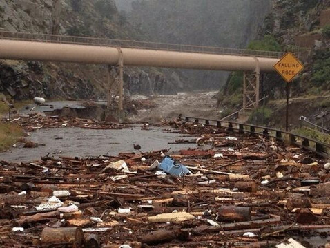
Amid the $2 billion in damage caused by flooding in Northern Colorado earlier this month is untold damage to water structures. “From preliminary estimates, I think this will be classed as one of the largest natural disasters in Colorado history,” said Alan Hamel, chairman of the Colorado Water Conservation Board.
At its meeting in Telluride this week, the board approved a $1.65 million emergency grant to assess damage to municipal water lines, ditches and other water structures in several counties. Board staff has been assisting other state agencies in dealing with the flooding and the aftermath.
The storms, which began on Sept. 12, have been classified by board staff as a 500-year-plus event over a widespread area, with local pockets of a 1,000-year storm. Up to 14.5 inches of rain fell in 36 hours, with more than 9 inches in 24 hours in some places.
More than 19,000 homes or businesses were damaged and 1,500 destroyed. Thousands of people were displaced and at least eight are dead. Numerous bridges and miles of roads need to be repaired in the wake of the flooding. “There was also damage to municipal and agricultural water structures,” Hamel said. “In some places, it relocated the rivers and, of course, washed away measuring devices. The town of Lyons may not have water for months.”
Most dams are believed to have held up during the storms, but inspections still are needed, he added.
The board is planning a special meeting in the near future to continue assessing damage and making recommendations for state response, Hamel said.
More CWCB board meeting coverage from Chris Woodka writing for The Pueblo Chieftain:
A study that will help sew together water systems in El Paso County received some state funding this week. The Colorado Water Conservation Board approved a $75,000 grant for a project by the Pikes Peak Regional Water Authority to analyze how water systems could work together. The study also will identify opportunities for sharing water resources and reusing water. That will be matched by $167,000 from El Paso County interests. The Arkansas Basin Roundtable gave its nod to the study in June.
The study is important for the entire Arkansas River basin because the largest part of the urban water supply gap in the basin is expected to come from growth in El Paso County.
As growth has occurred in the county, Colorado Springs and its neighbors have purchased agricultural water rights in other parts of the Arkansas River basin. State planning began a decade ago to find alternatives to the pattern of buy-and-dry. During that time, there have been more purchases of farm water by communities like Donala, Widefield and Fountain.
But some other attempts did not materialize because of higher costs and increased political resistance, such as Woodmoor’s attempt to buy water rights on several ditches or Cherokee’s rejection of a plan to pump water from Lamar.
A pipeline from either Avondale or La Junta was rejected by the Pikes Peak group as too expensive.
Lately, more cooperation is developing among water users to coordinate water supply activities. Cherokee and Donala are making plans to hook up with the Southern Delivery System being built by Colorado Springs. SDS, as designed, benefits Security and Fountain as well.
A task force is looking at coordinating stormwater efforts in El Paso County. Stormwater has become a major issue in developing water projects like SDS.
Some members of the Pikes Peak group also are interested in lease agreements with the Arkansas Valley Super Ditch, which was formed to market water without permanently selling water rights.
According to Don Hartley, a member of [Communities Protecting the Green], an organization known as the Colorado Wyoming Coalition is finishing a feasibility study involving the transfer of water from the Flaming Gorge. The coalition was originally known as the Parker Group, after the community in Colorado initially proposing the project, before it rebranded itself. According to a 2011 document titled “Flaming Gorge Investigation Status Report,” the municipal governments in Cheyenne and Torrington, along with the Laramie County government, are involved the coalition’s study to move water from the gorge to eastern Wyoming and northern Colorado.
The document states more than half a million people living in both states would be served by the project.
“It’s kind of slow right now, but things could get interesting once that study is completed,” Hartley said.
Hartley believes the study could be completed within a matter of weeks and said they need to be vigilant with the group because they pose the biggest threat to the river.
Hartley said the second issue on the horizon involves a state water plan under construction within the Colorado state government. One of the key issues Hartley and others at Communities Protecting the Green are watching involves the augmentation of the river to provide water to communities in Colorado.
More Flaming Gorge Pipeline coverage here and here.
Here’s a call to arms from Anne Castle writing for UTTV–San Diego. Here’s an excerpt:
Myth 1 — The silver bullet. It would be great if we could take a single, easy step to eliminate the projected gap between supply and demand. Unfortunately, that one definitive action does not exist. Our response must involve multiple sectors of the economy so that no one region or type of water use bears a disproportionate share of the load. No silver bullet will solve this problem — it will take multiple, incremental efforts.
Myth 2 — Cities just need to stop wasting water. Cities in the Southwest are models for the nation in their efforts to conserve water. Outside restrictions on water use are part of our Western landscape, and educating the public about water use in arid areas has garnered good results. Yet, the myth persists that we’d have plenty of water to go around if we stop watering golf courses in Phoenix or bluegrass in Denver or abolish fountains in Las Vegas or swimming pools in L.A. But the projected shortfall between supply and demand dwarfs any realistic estimate for additional conservation. Cities should and will do more, but this will be only one piece of the puzzle, not the entire fix.
Myth 3 — Water is too valuable to use on farms. Although about 80 percent of Colorado River water goes to agriculture, we would be unwise to assume that we can address shortages solely by removing irrigation water from farms. Retiring too much farmland will harm our economy in the Southwest, our food security and our quality of life. Further improving efficiency, judicious switching to less-thirsty crops, and using science to grow more with less water will be essential, but we must be careful not to destabilize rural economies that are the foundation of the basin.
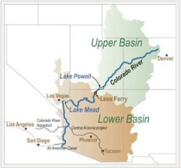
Myth 4 — The states can make this shortage go away. The seven Colorado River Basin states are the first responders in addressing drought, but they can’t do it alone. Interior has an integral role in any solution, given its unique interests and assets, not the least of which is its ownership of the major mainstem reservoirs. The 29 Indian tribes along the Colorado River have substantial interests and senior priorities for its water. Our partner in Mexico is joined with us by treaty and shared concern about the wise use of the river and the potential for revitalizing the delta connection to the Sea of Cortez. We must all work together to craft and implement solutions for sustainable use of the river.
Myth 5 — When times are tough, we can sacrifice in stream flows. Environmental and recreation flows aren’t just nice things to have; they’re essential drivers for the economy of the Southwest. Recent analyses and surveys have demonstrated that a flowing river floats hundreds of millions of dollars into the economy. Business interests up and down the river are increasingly and appropriately vocal about their stake in healthy flows. Maintaining beautiful waterways that support tourism, recreation, and ecosystems in and adjacent to the river is a necessary component of any solution.
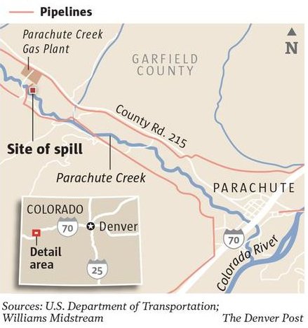
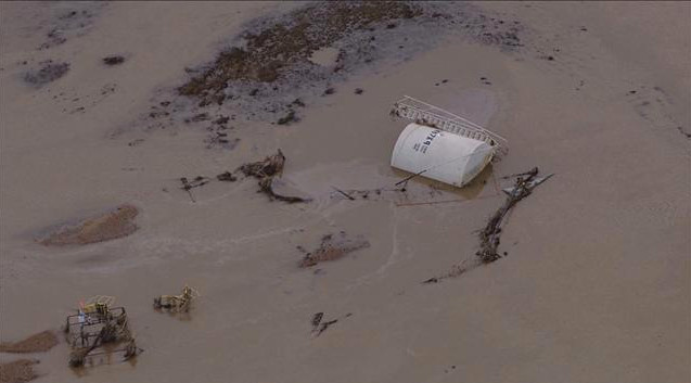
“So as the water crested there was a tremendous amount of I think earth moved in some cases to where the foundations to some of these tanks actually washed out underneath them,” says Dan Kelly, vice president of Noble Energy’s operations in the area.
The company reported four spills, amounting to almost 9,000 gallons of oil. In some instances the floodwaters quickly swept the oil downstream. In others, the company had to sop up the spilled oil or use vacuum trucks. Kelly says his company is still trying to gain access to a few sites.
“Due to the water, due to the currents, due to some of the other issues with potential pollutants — bacteria and some of the things we’re very concerned with — we have not aggressively pursued trying to get into some that still have risk,” he says.
The bacteria he’s referring to — from raw sewage and animal excrement from feed lots — have also spilled into floodwaters. Overall, state officials are warning people to stay away from the water. But not everyone can make that choice.
Riding on horseback, one of the few ways to get around near the South Platte River, rancher Kody Lostroh searches downstream from one oil spill area for a cow he lost in the floods.
“There’s a ton of junk in the water right now,” he says. “It’s just another thing we have to deal with.”
In total, state officials are tracking 12 of what they call “notable” oil releases in the region. Colorado’s oil and gas regulatory body has multiple teams in the field assessing the affects of floodwaters. Energy companies themselves are conducting aerial surveys of their equipment.
Some sites remain unreachable by land because roads are too muddy or have been destroyed. Overall, state officials estimate about 1,300 wells remain shut down.
The recent rainfall along the Front Range was phenomenal, by some estimates a 1,000-year event in terms of duration, volume and area. But the flooding?
Not so much, at least as measured by an obelisk along Boulder Creek in downtown Boulder.
Human memories about weather are unreliable. During many years living in Vail, how often did I hear that the latest powder storm was absolutely the best ever? Plenty. Flooding is like that, too, but maybe in reverse.
The turquoise obelisk in Boulder provides a better measure against long-term memory loss. Located near the Broadway bridge, it provides benchmarks for flood levels. The water this year lapped against the 50-year marker. Above it are others: 100 years, 500 years and, much higher yet, Big Thompson, a reference to the giant flood in that canyon between Loveland and Estes Park in 1976.
I was at the Big Thompson disaster. I was living in Fort Collins then and was among scores of young men (sorry, women, those were different times) with strong backs who could be summoned in case of forest fires. My only fire was at an old sawmill site in the foothills. The joke was that one of us had set the fire because we were so desperate for minimum-wage work.
Then came July 31. It was hot that night in Fort Collins. It hadn’t rained a drop.
I was living above Gene’s Tavern, just two blocks from the Larimer County Courthouse. When the call came, I was at the sheriff’s office almost immediately. It was 9 p.m.
Being among the first at the command center at the Dam Store west of Loveland, near the mouth of Big Thompson Canyon, I was assigned to a pickup dispatched to look for people in the water near the turnoff to Masonville. Already, the river was out of its banks. From the darkness emerged a figure, dripping and confused. “I went fishing at Horsetooth (Reservoir) and was driving home and then there was all this water,” he sputtered. He was befuddled. So were we.
Our leader decided we’d best get out of there. From what I saw the next morning, that was an excellent decision. Water later covered the road there, too. I spent the night at the Dam Store as the water rose. Helicopters were dispatched, but there was little that could be done. Our lights revealed picnic baskets, beach balls and propane bottles bobbing in the dark, roiling water that raced past us, but never any hands summoning help.
In the morning, we found those hands. The bodies were stripped of clothing and covered with mud. The first I saw was of a woman who we guessed was 18, not much younger than I was then. This thin margin between life and death was startling in my young eyes.
Eventually, 144 people were declared victims of the flooding that night (although one turned up alive in 2008 in Oklahoma).
Estes Park got some rain, but not all that much. The larger story was partway down the canyon, in the Glen Haven and Glen Comfort areas, where the thunderstorm hovered. In just a few hours, it dropped 10 to 14 inches of water.
Downstream in the canyon, just above the Narrows, some people were unaware that anything was amiss until they went outside their houses and saw the water rising in their yards. It hadn’t even rained there. One cabin I saw a few days later was stripped of doors and windows but stood on its foundations, a mound of mud 5 or 6 feet high in the interior. I seem to recall a dog barking as we approached, protecting that small part of the familiar in a world gone mad.
At the old hydroelectric plant where my family had once enjoyed Sunday picnics, the brick building had vanished. Only the turbines and concrete foundation remained. In a nearby tree, amid the branches maybe 10 or 15 feet off the ground, hung a lifeless body.
The river that night carried 32,000 cubic feet per second of water at the mouth of the canyon, near where I was stationed. It happened almost instantaneously — and then it was gone. It was a flash flood.
This year, the flows peaked at 10,000 cfs, but were more sustained and, according to reports, the damage inexplicably greater in portions of the canyon. There were horrors, too, but this year there was time for warnings.
After the 1976 flood, rain gauges were sprinkled in the foothills of the Front Range, up to 7,500 feet in elevation, where most heavy summer rains occur. That telemetrically transmitted information alerts police chiefs and sheriffs to flooding potential. That warning system may have saved lives this year.
Where does volume of this flood fit into the context of flooding in the last 150 years? That answer will have to wait. Many rain gauges were swept away, so peak flows will have to be calculated during field visits by U.S. Geological Survey personnel. That will take several weeks.
One more banner of comparison was 1965, when rivers and creeks from Castle Rock to Lamar to Fort Morgan flooded.
The flood that swept through Littleton and Denver created a mess, but led to the rethinking of the South Platte River as an asset rather than industrial afterthought.
East of Denver and Colorado Springs, the same storms transformed Bijou Creek from a lifeless expanse of sand into an angry, snarling mass of water. At Fort Morgan, after entering the South Platte River, it nearly submerged the arches of the Rainbow Bridge. This year’s flooding, according to several eyewitness accounts, didn’t even come close.
We’ve had other floods, too. Even in the midst of the Dust Bowl, there were giant floods in eastern Colorado, both on the South Platte and in the Republican River.
My guess is that this flood will be the most damaging ever in Colorado history. Part of this is due to how broad the inundation was, from Colorado Springs to Wyoming. Population growth is also part of the story. Colorado now has 5.2 million people, almost double that of 1970, most of us crowded between Castle Rock and Wellington, a good many in the foothills, those areas so vulnerable to fires but also flooding.
This flood once again points to the importance of land-use planning. Where you put sewer plants does matter. You can’t anticipate every natural disaster, but floods have an element of predictability.
Boulder has had big floods before, most notably in 1894. It also had the direct lesson of Big Thompson and the local influence of Gilbert White, who died in 2006. “Floods are ‘acts of God,’ but flood losses are largely acts of man,” he had said. Boulder has muddy feet, but the consequences would have been much worse had the city not taken his advice and removed structures from along the creek to the west and resized bridges to accommodate more water. The obelisk is in his honor.
John Pitlick, a hydrologist at the University of Colorado, says the flood this year peaked at about the 50-year marker on the obelisk.
In one of his classes, he also noted that rainfall and flooding aren’t one and the same. “It is possible from a statistical analysis to be a 1,000-year rain, but you don’t necessarily have a 1,000-year flood.”
In other words, context matters entirely. Had the water fallen in a shorter time, such as it did in the Big Thompson in 1976, Boulder’s story almost assuredly would have been different. “We might have seen a catastrophe,” he says.
That leaves us in something of a no-man’s land, as Pitlick puts it.
This year’s floods were a big deal but, aside from individual losses, not catastrophic to Colorado. What lessons do you draw for future flood planning? That’s the question for communities along the Front Range in months ahead.
The 1965 flood that devastated Denver remains the most costly natural disaster in terms of property loss in state history. It also prompted the building of Chatfield Dam and changed the face of the city.
In 1976, a storm dumped more than a foot of rain over Big Thompson Canyon and killed 144 people. It led to the establishment of safe areas and warning signs. A 1921 flood on the Arkansas River led to the rebuilding of Pueblo and the rerouting of the river.
Though usually tame, the waterways that tumble across Colorado’s rugged terrain have a history of turning deadly. At least three major floods over the past 100 years have left changes large and small in their wake.
It’s too soon to say what transformation could follow last week’s flooding.
“For a historian to predict the future is kind of like malpractice; we deal with the past, not the future,” said B. Erin Cole, assistant state historian. “They say history repeats itself, but it really never does.”
A string of menacing funnels materialized over the foothills on June 15, 1965, as a storm, which dumped 14 inches of rain in a little more than three hours, announced its presence with a blizzard of hail.
Jim Hier and a cousin were driving home from a job drilling wells north of Monument Hill. He looked back over his shoulder.
“South of Larkspur, I looked up at the valley where we had been and the whole valley was a lake,” said Hier, now 71.
The deluge began when Plum Creek breached its banks near the Palmer Divide, Cole said. As the water thundered toward Denver, “almost all the tributaries of the South Platte flooded.”
Hier, 26 at the time, and two cousins rescued an elderly man from the top floor of his home as the turbulent water was sweeping the house away.
The flood splintered homes and barns, drowned livestock and washed out roads. Debris that included butane storage tanks slammed against bridges, plugging the channels beneath them.
In Denver, the 15th Street bridge was one of 16 bridges destroyed. Somehow, the 19th Street bridge, built in the late 1880s, stood firm and remains in place, said Tom Noel, a history professor at the University of Colorado Denver
Over two days, the flood spread through 15 counties, inundating 250,000 acres and causing 21 deaths and $540 million ($3.9 billion adjusted for inflation) in damage.
Most of the damage was in Denver, Cole said. “It hit the most densely populated part of the state the hardest,” she said.
After the flood, the public clamored for a dam to protect the city, and Chatfield Dam was built.
As the city began to rebuild, some developers wanted to plant single-family homes along the waterway, Cole said. Instead, high rises went up, and over time parks and bike paths turned the once-polluted river into a popular amenity for residents and visitors.
The highest flood-related death toll was likely reached June 3-5, 1921, when torrential rains drenched Pueblo. Railroad cars were swept away, along with entire buildings, and after a fire started in a lumberyard, the raging waters carried burning planks through the city.
“Hundreds of people died, with some death toll estimates as high as 1,500,” according to the National Climatic Data Center. “Many of the dead were likely carried far down river and never recovered.”
A flock of blue wing teal ducks couldn’t wait for the official opening of a new reservoir east of Pueblo. The ducks were enjoying the water in channels of an excavation pit at Stonewall Springs Ranch, sharing the space with heavy equipment, conveyor belts and piles of sand.
But the reservoirs at Stonewall, strategically located downstream of the Fountain Creek confluence with the Arkansas River and upstream of most ditch headgates, will benefit people as well. “In the long term, this is the way to save agriculture as an entity in the Lower Arkansas Valley. This will provide storage for agriculture,” said John Singletary, chairman of the Colorado Parks and Wildlife Commission.
“It’s the first good chance for a water bank in the valley,” added Dan Prenzlow, regional manager for Parks and Wildlife.
The state plans to begin filling the first reservoir next spring, bringing a plan to life that has been hatching for some time. It is now being dug out to depths of 10-25 feet.
Unlike most gravel pit sites, the area has been carefully shaped by Parks and Wildlife with contours and features that improve habitat, Prenzlow said. Eventually, five reservoirs could be located on the site located south of U.S. 50 near Nyberg Road, filling by gravity from the Excelsior Ditch and releasing water into the Arkansas River.
While the reservoir is being built, associated wetlands are under development as well by Stonewall Springs LLC, which owns the property and mines it for gravel.
Parks and Wildlife, which is the state’s largest owner of water rights, wants the site to help use all of the water in the Arkansas Valley more efficiently.
Cities have eyed the area below Pueblo for years as a way to recapture water bypassed in the Arkansas River flow program through Pueblo. Farmers have seen the need for storage, but lack resources to develop it on their own. Having water in storage benefits waterfowl and other wildlife.
Rather than charge farmers to store water, the state would prefer to store their water during wet years for release during drier times. In the past, the state has purchased water from cities in dry years to maintain flows for wildlife, but in a year like this, none is available. The reservoirs at Stonewall Springs would give it a way to supplement flows.
“We’re looking at it as fitting in with the governor’s call to include everyone in a statewide water plan,” Singletary said.
Great Outdoors Colorado funds and private grants are being used to supplement state funds to pay $5 million for the first phase.
More infrastructure coverage here. More Stonewall Springs reservoirs coverage here and here.
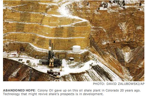
Oil shale has been the “next big thing” in Colorado for over 100 years. It looks it will take a bit longer to develop as Royal Dutch Shell is pulling out of the play in western Colorado. Here’s a report from Cathy Proctor writing for the Denver Business Journal. Here’s an excerpt:
“There’s been a shift in our oil shale project,” spokeswoman Carolyn Tucker said Tuesday. “The energy market has evolved since Shell first started its oil shale research project in 1981. We plan to exit our Colorado oil shale research project in order to focus on other opportunities and producing assets in our broad global portfolio,” she said in an email.
“Our current focus is to work with staff and contractors as we safely and methodically stop research activities at the site,” she said.
The announcement regarding the closure of Shell’s oil shale research and development work comes as the company announces plans to put its assets on the market across the United States, including oil and gas assets in northwestern and southeastern Colorado…
…scientists have spent decades trying to unlock oil shale’s bounty, and many believe that breakthroughs are years away — if they ever happen. Chevron, another Big Oil major, abandoned its oil shale research efforts in February 2012.
I hate to tell you that I told you so but here’s an article that I wrote in 2008 for the Denver Examimer.
From the Glenwood Springs Post Independent (Hannah Holm):
In 2008, the Colorado and Yampa-White Basin Roundtables, which are groups of stakeholders responsible for “bottom-up” regional water planning, commissioned a study on future water needs for energy development. The initial phase of the study raised eyebrows with the estimate that if oil shale really took off, the industry could be using nearly 380,000 acre feet of water/year by the 2040s, largely due to water use by power plants needed to provide the energy to extract oil from shale. An acre foot is approximately enough water to supply 2-3 households for a year.
A later version of the roundtables’ study revised the oil shale water use projections down significantly, in part by changing assumptions about how the energy for the extraction process would be generated (with less thirsty natural gas-fired plants rather than coal-fired plants). This version settled on an estimate of 120,000 acre feet/year to supply a large-scale oil shale industry and concluded that it could be supplied mostly from the White River.
Although significantly lower than the earlier estimate, 120,000 acre feet/year is still much more than the water needs projected for other energy development sectors in the region, including natural gas development. Water use of that magnitude could impact the state’s ability to develop water from the Colorado River and its tributaries for other uses, including meeting the needs of our growing cities. Current uses, such as irrigated agriculture, could also be impacted if senior water rights were applied to meeting the industry’s needs.
So … does Shell’s withdrawal from oil shale research in the region mean water planners no longer need to account for this potentially large increase in the use of our region’s water? Not necessarily, since several other companies are still actively working on their oil shale research and development projects.
However, since the water use estimates used in the roundtables’ studies were based largely on the technologies Shell was testing, the numbers will certainly need to be reconsidered, and the time horizon may be pushed back even further.
FromThe Grand Junction Daily Sentinel (Dennis Webb):
In a major setback to the effort to develop oil shale in the United States, Shell is closing down its research and development project in Rio Blanco County.
The company was the biggest player in oil shale in Colorado, holding three federal research, development and demonstration leases.
Shell spokeswoman Carolyn Tucker said the decision reflects an evolving energy market since Shell began its oil shale research in 1981.
“We plan to exit our Colorado oil shale research project in order to focus on other opportunities and producing assets in our broad Global portfolio,” she said in an e-mail. “Our current focus is to work with staff and contractors as we safely and methodically stop research activities at the site.”
In an interview, she said employment at Shell’s research site has ranged anywhere from 10 to 50, depending on activity levels.
“It’s not going to be an abrupt exit,” she said.
Shell has obligations and projects it needs to wind down, including reclamation and decommissioning work required by the Bureau of Land Management, she said.
Chevron, which also received a research and development lease from the BLM, decided early last year to divest itself of the lease, saying it wanted to focus on other priorities.
Just last month, Shell announced plans to sell its oil and gas project in Routt and Moffat counties. That followed an earnings decline and a review of Shell’s various oil and gas projects in the Americas, followed by a decision to keep those with the most growth potential.
At that time, Tucker said that decision had no bearing on its oil shale project, saying it involved a separate business that’s still in the research stage.
But she said this week’s decision results from another review project looking specifically at Shell’s oil shale assets, which also include holdings in Jordan and Canada.
“A number of factors went into the decision. Based on those many factors we’ve chosen to put those resources into the other oil shale assets and not in Colorado,” Tucker said.
The $2.4 million Lake Otonowanda Rehabilitation Project will allow the town to exercise its full decreed storage right by improving the lake’s capacity from 100 to 600 acre feet, while restoring the tunnel outlet near the reservoir to make the delivery system more efficient.
The town’s municipal water right on Lake O predates the Colorado River Compact, a 1922 deal made by seven U.S. states in the basin of the Colorado River in the American Southwest, which to this day governs the allocation of the water rights to the river’s water.
Currently, due to Lake O’s modest size and declining condition, the Ridgway stores only a fraction of the water to which it is legally entitled; the renovation will allow the town to maximize Lake O’s historic adjudicated capacity. Stored water will supply the town when its flow rights are out of priority, ensuring enough water for most anticipated situations, even during drought years, and accommodating growth well into the future.
When the renovation is complete, the town will be able to supply water to the community for a minimum four-month period in a drought event, compared to its current storage capacity of only 10‐14 days’ worth of water.
The rehabilitation project got the big green light earlier this month, when the Town of Ridgway finalized a $1.2 million grant/loan package with the Colorado Water Conservation Board that will contribute significantly toward financing the project…
Arguably among the most scenic municipal reservoirs in the nation, Lake O is located about three miles south of Ridgway off of County Road 5, in an alpine meadow encircled by ponderosa forests and pristine views of the Cimarrons and Sneffels mountain ranges. It is the town’s primary municipal water source; the town also holds junior flow rights on Beaver Creek and Cottonwood Creek/Happy Hollow that are more vulnerable to calls. Generally, the lake provides enough water for the town’s needs (with an average of 280 acre feet diverted each year), but in the drought of 2002, all of Ridgway’s water rights were called by downstream senior water rights holders. The state water engineer subsequently put the town on notice to shore up water rights and storage strategies to prevent this situation from happening again.
More Uncompahgre River Watershed coverage here and here.
“Some wastewater plants were completely flooded, some systems lost treatment capabilities for a while and some lost large segments of sewer lines, but the plant is still operating,” said Steve Gunderson director of the water quality control division at the Colorado Department of Public Health and Environment. “Also, we’ve seen pictures of people whose septic systems were ripped out and we have had reports from three animal feeding operations that had impoundments, where the animal waste is stored, that were impacted,” Gunderson told me Tuesday.
The state knows that the wastewater plant serving Evans has a capacity to process 1.2 million gallons per day was completely flooded by the South Platte River, Gunderson said.
And while the state health department works to figure out what was affected and how, it’s also waiting for the floodwaters to recede to start a sampling program to figure out what contaminants ended up where, he said…
The Colorado Oil and Gas Conservation Commission has said that about 27,000 gallons of oil spilled into the water from storage tanks damaged by the flood. By comparison, the oil spills represent about 4 percent of the 660,000 gallons it takes to fill an Olympic-sized swimming pool. The waste contained in the Evans plant alone would fill nearly two swimming pools…
The health department will start sampling programs as the water drops, but Gunderson said he believes — in the long run — that the flooded rivers will recover. “Water bodies have a way of cleaning themselves up, but we expect it will take time in some areas — the biology of the river has changed,” he said.
The rushing floodwaters probably killed some fish, but others survived and will replenish the stream, he said.
Saturday, 9/28 10-11:30am
Old Town Library, 201 Petersen, Fort Collins
Sen. John Kefalas and Representatives Randy Fischer and Joann Ginal will host a Community Issue Forum called: Developing the Colorado Water Plan: Ensuring Public Interests Have a Voice in Planning Colorado’s Water Future
You are invited to learn about the new state Water Plan, ask questions, and provide comments. The event is free, nonpartisan and open to the public.
Guest speakers will include:
·Mark Easter, Save the Poudre Board of Directors;
·John Stulp, Special Policy Advisor to the Governor for Water;
·Reagan Waskom, Ph.D., Director of the Colorado Water Institute;
·Robert Sakata, Brighton farmer; and
·Drew Peternell, Colorado Director for Trout Unlimited.
Even before a drop of water flows through Southern Delivery System, other El Paso County communities are making plans to hook up to the pipeline.
Donala Water & Sanitation District, which serves 2,600 people north of Colorado Springs plans to begin an environmental impact statement process with Bureau of Reclamation within the next two weeks in order to obtain a long-term storage contract in Lake Pueblo.
Cherokee Metro District, serving about 18,000 people in a community surrounded by Colorado Springs, wants to hook up to SDS in the future.
Those communities will be held to the same environmental commitments, including federal environmental review and stormwater management, under Pueblo County’s 1041 permit.
Donala purchased a ranch south of Leadville for its water rights in 2009, but will need SDS to deliver about 280 acrefeet annually — about 25 percent of its needs. “We have been talking to the city for years,” said Kip Peterson, manager of the Donala District. Donala already has a temporary contract in place to use Colorado Springs water delivery systems to deliver water from the ranch.
Stormwater controls are problematic, because 95 percent of the land in Donala already has been developed, but the district is looking at how to amend its plan to address stormwater, Peterson said.
Like Donala, Cherokee has a contract to buy water from or have its water delivered by Colorado Springs Utilities. Cherokee has a two-year lease from the Pueblo Board of Water Works. Cherokee gets most of its water from wells, but needs additional sources to round out its supply. “Unlike Donala, we don’t yet own any water we could store in Lake Pueblo,” said Sean Chambers, Cherokee manager.
But Cherokee is interested in using SDS for the long-term. Like Colorado Springs, it has some water and wastewater lines that cross Sand Creek, a tributary of Fountain Creek. Those would be held to the same level of scrutiny as Colorado Springs lines.
More Southern Delivery System coverage here and here.
A rift between Colorado Springs City Council and Mayor Steve Bach widened Tuesday over the issue of stormwater funding. Colorado Springs City Council voted Tuesday to spend $35,000 to support a stormwater task force, matching $35,000 each from Colorado Springs Utilities and El Paso County, for a total of $105,000. Council also voted to hire its own legal counsel for stormwater issues.
There has been pressure from Pueblo County and the Lower Arkansas Valley Water Conservancy District to fund stormwater projects as part of Colorado Springs’ environmental commitments relating to the Southern Delivery System.
The move comes as the task force is moving toward putting a stormwater tax on the November 2014 ballot as a way of addressing a $900 million backlog in stormwater needs through a regional approach. It also reflects dissatisfaction with Bach, who has refused to participate in stormwater task force meetings.
City Attorney Chris Melcher angrily contested the move, claiming that his office has attorneys with expertise in stormwater, but had never been asked to advise council on stormwater. He said the city charter does not allow conflicting legal opinions and he questioned the expenditure both by council and Utilities.
Several council members rebuked Melcher, asking why no one from his office has attended high-profile task force meetings, and why he has favored Bach on matters related to stormwater. “I understand you’re hired by the mayor, but that’s not my issue,” Council President Keith King told Melcher, adding that if it were possible, council would fire him. “We have not been given the kind of service that we need.”
“If you pass this resolution and decide to act, it is in violation of the charter,” Melcher said.
Council has worked with El Paso County for more than a year to develop a regional approach to stormwater, but now fears that it would again be underfunded as the mayor moves ahead with a separate approach to lump infrastructure needs into one funding scheme. “I’m concerned that stormwater would be folded into all the other infrastructure needs,” said Councilman Joel Miller.
Larry Small, a former councilman who is the executive director of the Fountain Creek Watershed Flood Control and Greenway District, urged council to continue the regional approach, saying it has worked well on other issues such as transportation in the Pikes Peak area.
Doug Bruce, a former county commissioner, state representative and convicted tax evader, contested council’s move, saying it is a waste of money that doesn’t solve anything. Bruce said the money would be better spent cutting down trees that have been allowed to grow in Fountain Creek.
Paul Kleinschmidt, of Taxpayers for Budget Reform, opposed spending money on the task force as well. “We could spend billions, but we can’t stop the flooding,” he said.
Colorado River Basin including out of basin demands — Graphic/USBR
FromThe Grand Junction Daily Sentinel (Gary Harmon):
Sin City is preparing for a time when it might have to go without. Without its full share of Colorado River water, that is. “We’re planning for a future without access to our (Colorado River) compact entitlement,” John Entsminger, senior deputy general manager of the Southern Nevada Water Authority, told about 200 people at the Colorado River Water Conservation District’s water seminar Friday at Two Rivers Convention Center.
Las Vegas is far from profligate with its use of water from the Colorado, Entsminger said. Not only is all the water used indoors on the famous Las Vegas Strip treated and returned to nearby Lake Mead, the city has instituted significant conservation efforts, Entsminger said. As a result, its water use fell from 325,000 acre feet of water in 2002 to 222,000 acre feet in 2012 while the city population grew by 400,000. Part of the reason for that is high water rates that put Las Vegas in the top 15 percent of western cities, he said.
Las Vegas, meanwhile, has started its own transbasin diversions of water from within the state and is working with other lower-basin states on projects to desalinate salt water, he said.
The state’s Colorado River water is pivotal for 70 percent of the state’s economy, Entsminger said.
Las Vegas uses most of the state’s 350,000 acre feet of water, a portion of the 7.5 million acre feet of water the upper basin of the Colorado River is required to deliver annually to the lower basin.
More coverage of the Colorado River District’s September 13 seminar from Gary Harmon writing for The Grand Junction Daily Sentinel:
A call by Grand Valley water users for the Front Range to seek out water supplies other than from the Western Slope can’t work, the new head of the Colorado Water Conservation Board said. Augmenting the amount of water available from another basin might be technically feasible but it would be futile in the face “of political and practical reality,” James Eklund, director of the Colorado Water Conservation Board, said Friday at a water seminar sponsored by the Colorado River Water Conservation District. About 200 people attended the seminar at Two Rivers Convention Center.
Grand Valley water officials fashioned their call for eastern Colorado to find new sources of water in response to Gov. John Hickenlooper’s call for a statewide water plan, to be complete by December 2015.
While it would be impossible to import water, Eklund said there are still possibilities to make better use of water within the state. “We can solve our problems in Colorado,” he said in an interview, noting that additional storage will be considered in the drafting of a statewide water plan.
Colorado is projected to grow to 7 million residents by 2030, Eklund said, calling for water officials around the state to confront skepticism and work together. People are skeptical of a statewide water plan because they fear what might happen to existing water law, but they have to seek out ways to meet in-state demands and to avoid federal interference. he said.
“The water landscape has shifted,” Eklund said. “If we want to have a different future for Colorado, it won’t happen by accident.” Coloradans, he said, in the meantime, will draw together in the face of disastrous flooding on the Front Range, especially in Boulder County.
“We’ll pull together to face this,” Eklund said.
Eklund, a Grand Junction native with family roots in Collbran and Cedaredge, was appointed to head the state water agency this year after having served as the senior deputy legal counsel to Hickenlooper and as an assistant state attorney general.
Location of spill on Parachute Creek 2013 — Graphic/The Denver Post
FromThe Grand Junction Daily Sentinel (Dennis Webb):
State regulators have finalized an agreement with a Williams subsidiary, finding it in violation of Colorado law and an associated rule in connection with a natural gas liquids leak near Parachute. Regulators also have cleared another company in the incident.
The Colorado Department of Public Health and Environment and Bargath LLC reached what’s called a compliance order on consent in August. The department’s Hazardous Materials and Waste Management Division found Bargath in violation for having released hazardous materials to the environment without a permit.
The leak from a pressure gauge on a pipeline leading from Bargath’s gas processing plant resulted in high benzene levels in groundwater and occasional small amounts of the carcinogen in Parachute Creek. No benzene has been detected in the creek since August.
Meanwhile, the division has informed WPX Energy, an exploration and production company that owns the property where the leak occurred in a pipeline right of way, that it is closing enforcement action it had begun against WPX with no further requirements. The division indicated in a letter that WPX demonstrated “it did not cause or control the operations causing the release” of the natural gas liquids.
Additionally, last week Colorado Oil and Gas Conservation Commission director Matt Lepore wrote to WPX that a notice of alleged violation it brought against WPX in March, when that agency first began investigating the case, has been closed. That’s because of COGCC’s decision to transfer the matter to the CDPHE after determining the leak wasn’t under its jurisdiction because it didn’t involve exploration and production waste.
Bargath continues to contend the liquids were indeed such waste and not subject to the hazardous materials division’s jurisdiction. But in signing the consent order it chose not to contest the issue. “They stepped up to the plate and decided not to fight even though they felt strongly about this,” said David Walker, an environmental compliance officer with the division.
The consent order includes no fines against Bargath, although that doesn’t preclude other state agencies from pursuing fines in the case. Division officials say the lack of a fine is based on the lack of negligence and the non-willful nature of the leak.
The agreement does call for Williams to pay $8,400 to reimburse division staff for its time working on the matter to date, and the company will continue to be billed for future expenses.
Walter Avramenko, the division’s hazardous waste corrective action unit leader, said Williams also probably already has spent several million dollars on the cleanup, which ultimately could cost it tens of millions of dollars.
The compliance order’s focus is on establishing requirements and schedules for Williams’ continuing cleanup of the leak, which could last a couple of years, followed by a long period of monitoring, Walker said.
In addition to other efforts, Williams has begun pulling contaminated groundwater from the ground, cleaning it with a treatment system and returning it to the aquifer.
Williams believes the leak occurred from Dec. 20 to Jan. 3. It estimates about 50,000 gallons of hydrocarbons leaked, with most of that vaporizing but about 10,000 gallons reaching the ground. The violation is based on groundwater benzene levels at 11 monitoring points that exceeded 0.5 parts per million, the minimum amount for which the division considers to be benzene in a liquid to be a hazardous waste. Readings at those points ranged from 7.5 to 38 parts per million.
However, the division is striving to have Williams clean up the benzene to the state’s much stricter groundwater standard of 5 parts per billion. That’s also the federal drinking water standard, although the state doesn’t consider the creek a drinking water source.
Williams personnel first discovered the leak Jan. 3 but thought it involved perhaps 25 gallons. They had dealt with an air line freezing causing a valve to close, and assumed that overpressurized and broke the gauge, Walker said. Only later did they realize the gauge had broken much earlier. Williams discovered the actual size of the leak in March during excavation work for a new pipeline.
US Drought Monitor Colorado Map September 17, 2013
FromThe Grand Junction Daily Sentinel (Gary Harmon):
Rainstorms that pelted the West Slope while pounding the Front Range last week closed the major transmountain diversions that fed hardest-hit cities to the east. Stopping the diversions, however, isn’t expected to translate into significant storage increases on the West Slope after one of the driest winters on record.
Water managers on the West Slope “never count on rain to boost storage,” Colorado River Water Conservation District spokesman Chris Treese said. “If we had gotten East Slope volumes, we would have gained some storage — depending on location. But short of 1,000-year events, rain doesn’t boost storage, it just maintains storage by easing demands.”
“And likely more importantly, the soil moisture throughout the arid west received a huge bump,” Treese said.
The river has since dropped, though, and the call for the Shoshone generating station in Glenwood Canyon is back on. The water level of Lake Powell rose about two feet since the storm, or about 200,000 acre feet, Treese said. That’s less than 1 percent of the 26 million acre feet Powell can hold. The lake is about 44 percent full.
Even with the storms, storage on the West Slope is about where it would normally be at the end of summer, Treese said.
Front Range water managers were filling Estes Lake, which generally contains 97 percent water diverted from the West Slope through the Adams tunnel, entirely on runoff from the storms, Kara Lamb of the U.S. Bureau of Reclamation said.
Denver Water officials stopped diversions through the Roberts and Moffat tunnels but officials said they didn’t know how long the water would be shut off because those tunnels respond to calls from the South Platte River and customer demand.
Water officials shut down the Adams tunnel soon after the downpour set off alarms, warning officials with Reclamation and the Northern Water Conservancy District that Estes, designed to regulate the flows from across the Continental Divide, was being overwhelmed. Managers modified the way the system works “on this side to lessen the flood damage that would occur in Big Thompson Canyon,” Northern General Manager Eric Wilkinson said. Flood waters were shunted into Horsetooth and Carter lakes for a few days until debris closed off that option, “and we were unable to alleviate some the flows,” Wilkinson said.
Northern has two canals that showed considerable damage from the floods, but the district fared better than some ditch companies and other irrigators, Wilkinson said.
Some irrigation companies saw the bottoms of ditches scoured so deeply by the floods that the water now runs below their intakes, Wilkinson said.
Making repairs will take months, but, Wilkinson said, “We hope by winter to have the system back in fairly good order.”
Attempting to separate Chatfield Reservoir and Chatfield State Park is a bit like splitting conjoined twins. There is significant risk, potential reward and inevitable growing pain. Yet that’s essentially what the proposed Chatfield Reservoir Storage Reallocation does. The plan to double water storage in the reservoir from its current recreational pool size will significantly alter the identity of the popular park that relies upon it.
The comment period on the project’s Final Environmental Impact Study closed at the beginning of September, and if the recommended alternative for reallocation is approved, neither Chatfield will ever be the same.
“It’s going to change the way the park operates if it goes through,” Chatfield State Park manager Scott Roush said. “The way we operate now, we know the water that Denver has is going to be there when we fill the reservoir back up in the spring. With this new plan, the reservoir is expected to fill up maybe three out of every 10 years. That makes it hard on the recreational side.”
Constructed on the South Platte just south of Denver in 1975, Chatfield Reservoir was built for both flood control and recreation. The 1,423-acre reservoir and encompassing 3,768 acres of land are owned by the U.S. Army Corps of Engineers and leased to Colorado Parks and Wildlife in 25-year cycles currently running through 2028. The park originally opened in 1979, the same year the state arranged an agreement with Denver Water granting storage rights in the reservoir with the understanding that, in general, it would be operated to allow for 20,000 acre-feet of storage (5,427-foot elevation) every summer for recreational purposes. From Memorial Day to Labor Day, Chatfield typically fluctuates no more than 5 feet. According to Roush, 2013 marked the first summer since 1979 that the pool dipped below the baseline elevation of 5,423 feet.
“That’s a pretty good track record,” Roush said. “We’re trying to maintain the water in the reservoir at a reasonable level for recreation like we’ve been able to do in the past. Visitors that come to Chatfield, that’s what they’re used to.”
Consensus holds that will no longer be the case should the reallocation proposal preferred by the Corps of Engineers be approved by federal and state officials as soon as January 2014. That plan to allow up to 20,600 additional acre-feet of storage for a conglomeration of municipal, industrial and agricultural water providers would raise the reservoir 12 vertical feet.
But the Corps’ own analysis recognizes that the junior water rights of the reallocation mean filling the pool to the new operating elevation of 5,444 feet will be inconsistent at best. And the absence of an operating agreement akin to the 1979 contract leaves park managers to deal with potentially frequent water fluctuations of 17 feet or more, affecting recreational users in a number of ways.
Filling the reservoir to the new level will flood 587 additional acres. Roads, parking lots, beaches, bike paths, trails, boat ramps, picnic shelters, fishing ponds and dog parks will be inundated. Restrooms and other buildings will be relocated to more than 600 horizontal feet above the low water line. Many relocated facilities will be constructed within the 10-year floodplain in order to provide reasonable access to the reservoir.
In a recent report to the state Parks and Wildlife Commission, Roush cited an increase in boating hazards along the reservoir’s shallow southern edge, shoreline mudflats exposed in dry years, loss of existing wetlands and new weed proliferation because of more frequent and greater water level fluctuations. Increased bank erosion is anticipated along with the loss of 0.7 upstream miles of the South Platte and wildlife habitat as up to 285 acres of trees will be removed.
Increased water fluctuation may disrupt spawning and recruitment of the lake’s wild smallmouth bass, CPW senior aquatic biologist Ken Kehmeier said. Similarly vacillating water levels are associated with elevated mercury levels in walleye at other reservoirs. Kehmeier says the proposal is likely to result in an additional 70 “zero flow” days per year in the South Platte below the Chatfield dam.
“We’ve been in discussion with the participants for the last year to try to put together a plan that would, if not mitigate, then minimize impacts. The toughest ones, obviously, have been park infrastructure and taking care of the park itself. And then the downstream issues,” Kehmeier said. “Because they’re such junior rights, there’s going to be a lot of years that they’re not going to have any water to release.”
Officials estimate a three-year construction period to restore services and implement proposed environmental mitigation in the park that annually attracts more than 1.5 million visitors and generates $2.2 million for the economically strapped state park division.
Not everyone believes the park’s current natural aesthetic can be re-established, however. “The quality of the recreational experience will be vastly different,” said Gene Reetz, a retired EPA employee and volunteer with SaveChatfield.org. “A lot of people think it will be just like it is now, only with higher water level. But most of the time it won’t be like that. It would be pretty devastating, not just to recreation, but to wildlife as well.”
Project proponents such as Rick McCloud with Centennial Water and Sanitation District maintain that even a changed Chatfield will remain a superb recreation and wildlife area. Others are skeptical. “I’m concerned as a manager about how successful the mitigation will be,” Roush said. “Is it going to be successful enough to maintain what you have today?”
The Colorado Climate Center, the National Integrated Drought Information System and other agencies hold regular conference calls to determine what the next regional drought map should look like. As you’d expect, the flood-drenched areas of the Front Range have been removed from any drought designation. Most of the Western Slope, though, remains in “moderate” drought, despite the fact that the Water Center at Colorado Mesa University reports most of the region received at least 150 percent of its usual rainfall between Aug. 18 and Sept. 16…
State climatologist Nolan Doesken said the western part of the state has had enough rain to relieve “vegetative water” issues — keeping everything green. Streamflow is another matter.
“We still have the impacts of long-term dryness,” Doesken said. That dryness means streamflows, which are still suffering a kind of hangover from 2012. Doesken said the snowfall we received in April and May helped bolster stream levels, but the ground on the mountainsides was so dry from the drought that much of the late-season snow soaked in before it could run off into streams.
While streamflows have stayed below normal this season, the massive rainfall on the northern Front Range has helped the Colorado River going into the fall, according to a report from Hannah Holm, coordinator of the Water Center at Colorado Mesa University. The Colorado is tapped for Front Range use, mostly from high-elevation reservoirs in Summit and Grand counties. Since there’s no real need for Western Slope water right now, reservoir levels and Colorado River streamflows will be healthier than usual this fall.
That will help the river going into the next “water year,” which starts Oct. 1. And, Doesken said, September rains have helped build ground moisture going into this next year…
Doesken said that Klaus Wolter, a researcher at the Cooperative Institute for Research in Environmental Sciences at the University of Colorado at Boulder, has a more clear estimate for the fall. In the last drought report conference call Doesken said Wolter showed “distinct optimism” that the state could have a nearly-average fall season.
“Everyone (on the call) really breathed a sigh of relief when we heard that,” Doesken said. “It would really be nice to have a year that’s near average.”
Colorado is undertaking the largest emergency dam inspection program in state history, seeking to check 200 dams in 10 days, mostly along the South Platte River and its tributaries. All of Colorado’s high-hazard dams, which likely would kill people if they fail, withstood the recent record rainfall. But nine low-risk dams have breached, and an uncounted number of small ponds overflowed, contributing to the flood. Twenty other dams can be reached only by helicopter because roads below them washed out.
At least 55 engineers have offered to help the state dam safety branch with the inspections, and the agency has called all of its engineers in western Colorado to Denver.
In two days, “we had to write up the plan for what we wanted these engineers to do,” dam safety chief Bill McCormick said. “They’ll help do a workload that would have taken us six months.”
The inspectors will be looking for problems like increased seepage from large earthen dams, damaged spillways and clogged drainage outlets. Some small lakes and reservoirs might have to be drained for repairs.
McCormick, his deputy Scott Cuthbertson and John Batka, a safety engineer for dams along the St. Vrain and Big Thompson river systems, set out Thursday afternoon to see some of the known damage to the dams.
In Boulder County, at Pella Ponds Park, a trail system winds past a trio of ponds and lakes beloved by anglers and birdwatchers. The flood breached two, and their waters are pouring out. The parking lot is a cavernous hole, tipping over an outhouse at the edge. The trail, now a bumpy mix of gravel, stones, driftwood and landscape fabric, ends abruptly at a 10-foot-high cliff. The nearby St. Vrain River demolished this park.
“Utter devastation throughout the floodplain,” Batka said. “Whatever was in its path.”
Upstream, the river jumped its banks and formed new channels. The deluge filled McCall Lake, a high-hazard reservoir saved by its spillway.
At Left Hand Valley Reservoir, two spillways sent water over the edge. One, a staircase of concrete, survived with little apparent damage. The other, which doubled as the road to the reservoir, was destroyed. A 3-foot emergency berm now blocks the base of the access road. Above it, floodwaters carved giant gullies all the way to bedrock. It is among 70 reservoirs whose waters roared down spillways, some for the first time since they were built.
“This is a generational event,” Cuthbertson said, surveying the wreckage.
The dam safety program already took emergency action at 14 locations. One was Gaynor Lake, a Boulder County open space reservoir near houses and roads. When the lake filled, emergency workers brought in a backhoe to clear out clogged outlet ditches, leaving behind a mess of equipment tracks and a urine-like stench emanating from piles of dead cattails. Its embankment is temporarily braced with sand and gravel. McCormick watched the lake draining away for dam repairs. “We saw this as a serious condition,” he said.
He said Colorado residents can be thankful that its most hazardous dams met strict engineering standards and that grants from the Federal Emergency Management Agency’s national dam safety program helped train engineers and dam owners for this crisis. He said he hopes that a massive dam inspection program will find any hidden dangers — and reassure the worried people who call his office daily to report potential dam failures.
One came from a personal acquaintance who lives near the Button Rock reservoir in Larimer County. “Everyone in this neighborhood is on edge,” she told him.
Record flooding continues in western and central Nebraska as the water that inundated Colorado flows east, but it appeared to cause few major problems because communities were able to prepare.
The National Weather Service says the South Platte River rose to 14.2 feet in North Platte to set a new record on Sunday. The previous record level of 14 feet was set in June 1935. The river also set a record in Brady at 9.85 feet Sunday — eclipsing the previous mark of 9.6 feet. Records were already set upstream in Roscoe, Neb., and Julesburg, Colo., late last week.
“I knew a dam had breached above Lyons, so the cops and I thought there was a wall of water headed our way. I remember being kind of freaked out.” [Gary Lindstrom] said he was relieved when the roadblock was moved east on 66 to 53rd Street.
Here’s a photo gallery from The Atlantic (Alan Taylor).
A major water pipeline through Pueblo County has moved quickly since construction began two years ago. A connection at Pueblo Dam is complete, all but a fraction of Southern Delivery System pipeline is in the ground and work will start soon on the Juniper Pump Station, Colorado Springs Utilities officials told Pueblo County Commissioners last week.
“There has been significant progress on construction in Pueblo County,” said John Fredell, SDS program director for Utilities. That includes more than 18 miles of pipeline through Pueblo West and the northern part of Pueblo County on Walker Ranches.
Under the 1041 permit, Colorado Springs also has committed to spend at least $145 million in mitigation. About $42 million of that has been spent so far.
Commissioners are reviewing Colorado Springs commitments made under the 2009 1041 permit. Terry Hart, Sal Pace and Liane “Buffie” McFadyen all joined the board this year, and were not on the board when the permit was issued. Friday’s meeting was an opportunity for them to evaluate SDS compliance.
SDS also benefits Pueblo West, by more than doubling its water supply capacity and giving it another way to deliver water from Pueblo Dam.
“On our own, it would have been difficult to accomplish this,” Pueblo West Manager Jack Johnston told commissioners. “It’s been a $6 million cost to Pueblo West of a $30 million project.” Pueblo West now has a line that delivers 12 million gallons per day from the South Outlet Works. When SDS is complete, it will have another 18 million-gallon line from the new North Outlet Works. “Everything they committed to has been exceeded,” Johnston said.
Pueblo County staff has received quarterly and annual updates on compliance with the 1041 regulations, said Keith Riley, deputy program director for SDS. During the four-hour hearing there were some complaints from Pueblo West landowners about the way they have been treated as the pipeline crossed their property. But Riley pointed out that condemnation of property was a last resort, and some of the purchases of houses along the route provided materials for Habitat for Humanity and training opportunities for firefighters. Any large project is bound to leave some people unhappy, he said. “My heart goes out to those who have been (adversely) affected,” Riley told commissioners. “Our staff does care about landowners and we plan to respond to each point.”
Hart, who chairs the commission, said the county plans to see that Colorado Springs lives up to its commitment. “We’ve directed staff to match the comments we heard today with the conditions in the 1041 agreement and see if we can settle the differences,” Hart said.
While Colorado Springs officials painted a serene picture of compliance with Pueblo County 1041 permit conditions, local landowners offered different viewpoints. After listening to a presentation addressing major points of the Southern Delivery System by Colorado Springs Utilities staff, several people took issue with the rosy outlook.
Dwain Maxwell plopped down a 6-inchthick stack of paper and explained how a team of Colorado Springs lawyers outflanked him in court over what he says is a low-ball property appraisal for an easement on his property in Pueblo West.
LaVetta Kay told about how her complaints of workers trespassing on her property were disregarded by SDS management.
Engineer Laurie Clark showed photos of how large areas of pipeline revegetation areas on Walker Ranches have been washed out by relatively light summer storms.
Jane Rhodes talked about how unchecked flows on Fountain Creek continue to wash acres of her ranch land downstream. “I only have two acres, but they’re just as important to me as Gary Walker’s thousands of acres,” Maxwell told the board.
A Pueblo district court jury awarded Maxwell only $1,850, rather than the $2,200 Colorado Springs Utilities first offered him or the $18,500 his own appraiser valued the property. Commission Chairman Terry Hart asked Keith Riley, assistant project director for SDS, why Utilities did not pay Maxwell the amount it originally offered. “What I worry about when I hear about this is that Mr. Maxwell was not properly represented,” Hart said.
“The court ordered us to pay $1,850,” Riley replied.
Maxwell said the construction led to dust and disruption. Revegetation has created 4-foot tall weeds due to overwatering, but little grass. “Their promises have not been followed,” Maxwell said. Construction has created problems for Kay as well.
“I get no communication,” she said. “There’s no accountability. They disrespect me and disregard my property.”
Clark’s photos countered Utilities slides that portrayed orderly green belts along the pipeline route. Instead, large ravines that cross the pipeline route were gouged out, ruining revegetation that had begun. Utilities is aware of the problems and is working with Walker to solve them, said Mark Pifher, permit manager.
Rhodes’ problems relate to stormwater control, a long-standing problem on Fountain Creek that she believes will be made worse by SDS. “With all of the water coming from the north, when SDS gets done and in full force, we possibly won’t have any farms on Fountain Creek,” Rhodes said.
Commissioners directed staff to compile complaints according to conditions Colorado Springs agreed to in the 1041 permit and determine if they can be resolved. “This gives us an opportunity to address any issues out there and see where we are headed,” Hart said.
Colorado Springs indicated it would work with Pueblo County in resolving issues. “We take our obligations seriously and are sure that we could meet every one of them,” Utilities CEO Jerry Forte told him.
The Southern Delivery System construction has provided a shot in the arm to Pueblo County’s economy, commissioners heard during a meeting last week on the progress of SDS. “There has been a positive economic benefit to Pueblo,” said John Bowen, president of ASI Constructors.
The Pueblo West company won a $50 million contract for construction of the North Outlet Works at Pueblo Dam and some of the pipeline associated with SDS. “We’ve added employees during the recession,” Bowen said. “We are part of balancing the public trust with environmental concerns.”
It is important to ASI and Pueblo County for SDS to stay on course for its 2016 completion, because that will speed up work on Fountain Creek. ASI would be among bidders for future dam projects, he said.
Sherri Weber of M&S Trucking in Boone also spoke of the economic benefits. The company has hauled materials to construction sites for nearly two years under its SDS contract.
Overall, Colorado Springs Utilities said it has spent $60 million with more than 100 Pueblo County contractors. The total spent through the end of July on SDS construction was $382 million.
Pueblo County commissioners Friday looked at a menu of issues ranging from economic benefits to environmental damage surrounding construction of the Southern Delivery System pipeline through the county. Hanging over the discussion like a storm cloud, however, was whether Colorado Springs is serious about reining in flood control, as its council once promised. “In light of the recent flooding in Colorado Springs, this is a timely meeting that brings up concerns that have been with us for a long time,” Commissioner Sal Pace said. “The low point was in 2009, with the elimination of the stormwater enterprise.”
It was a repeated theme throughout a four-hour meeting. Resolving Fountain Creek issues played a big role in years of discussions that led to Bureau of Reclamation approval of the $940 million SDS project.
The 1041 permit itself does not require any level of spending or even that a stormwater enterprise has to be in place. It only requires that return flows from SDS do not exacerbate flows, said Mark Pifher, SDS permit manager. That position is being contested by the Lower Arkansas Valley Water Conservancy District, which this week decided to sue the Bureau of Reclamation, which issued a favorable record of decision for SDS based on the existence of a stormwater enterprise.
At Friday’s meeting, Jay Winner, Lower Ark general manager, asked Colorado Springs officials why council chose to drop the stormwater enterprise in 2009 while ignoring the main goal of the 2009 Proposition 300, which was to eliminate Utilities transfers to the city’s general fund. The move came after Springs voters defeated a 2008 issue to make stormwater payments voluntary. “As elected officials, we felt there was a message from voters that the stormwater fee should be stopped,” said Colorado Springs Councilwoman Jan Martin, the only council member still serving who was on the board in 2009. She voted to repeal the enterprise.
Martin is working on a stormwater task force that plans to put a ballot issue for a stormwater fee or tax on the November 2014 ballot in Colorado Springs and El Paso County. What appears on the ballot depends in part on a prioritization of needs ordered by Colorado Springs Mayor Steve Bach, who has not cooperated with the task force.
Dorothy Butcher, a former state representative from Pueblo, questioned how much of current stormwater spending in Colorado Springs, reported at $46 million, is addressing the issue of reducing Pueblo flood impacts. “With your potential 2014 ballot initiative, if it’s turned down, what source of revenue will you use?”
Martin said the council would transfer money from other sources, as it is doing now, adding that she is confident voters will support a ballot issue that clearly outlines its purpose, such as last year’s ballot measure to continue a transportation tax.
More Southern Delivery System coverage here and here.
Nearly one in 10 U.S. watersheds is “stressed,” with demand for water exceeding natural supply, according to a new, CIRES-led analysis of surface water in the United States. This map shows all stressed watersheds in the continental US
Here’s the release from the University of Colorado:
Nearly one in 10 U.S. watersheds is “stressed,” with demand for water exceeding natural supply, according to a new analysis of surface water in the United States. What’s more, the lowest water flow seasons of recent years—times of great stress on rivers, streams, and sectors that use their waters—are likely to become typical as climates continue to warm.
“By midcentury, we expect to see less reliable surface water supplies in several regions of the United States,” said the study’s lead author, Kristen Averyt, associate director for science at the Cooperative Institute for Research in Environmental Sciences (CIRES) at the University of Colorado Boulder. “This is likely to create growing challenges for agriculture, electrical suppliers and municipalities, as there may be more demand for water and less to go around.”
Averyt and her colleagues evaluated supplies and demands on freshwater resources for each of the 2,103 watersheds in the continental United States, using a large suite of existing data sets.
They identified times of extreme water stress between 1999 and 2007, and they estimated future surface water stress—using existing climate projections—for every watershed. In the paper, published online in Environmental Research Letters on Sept. 17, the authors also diagnosed the reasons contributing to stress.
Across the United States, the team found that water supplies are already stressed (i.e., demands for water outstrip natural supplies) in 193 of the 2,103 watersheds examined. In addition, the researchers reported:
The U.S. West is particularly vulnerable to water stress, for two reasons: 1) the differences between average demand and average supply are relatively small, so slight shifts in either supplies or demands can trigger stress, and 2) Western water users have long relied on imported and stored water to supplement natural supplies, in order to meet demands.
In most parts of the country, agriculture requires the most water, and contributes most to water stress.
In Southern California, thirsty cities are the greatest stress on the surface water system.
In scattered locations, the cooling water needs of electric power plants represent the biggest demand on water.
“A single power plant has the potential to stress surface supplies in a local area,” said co-author James Meldrum, a researcher in the Western Water Assessment, a program of the National Oceanic and Atmospheric Administration (NOAA) and CIRES. It’s critical to understand how various sectors contribute to the stress on a water system, Meldrum said, because effective remedies depend on accurate diagnosis.
Agricultural and municipal demands are spread among many users, for example, allowing flexible changes in water use and efficiency of use. “But because power plant decisions are so capital intensive, they tend to be locked in for a long time,” Meldrum said. “With the potential for increasing water stress in the next few decades across parts of the United States, power plants—and our access to electricity —may be put at risk when water is not adequately considered in planning.”
The authors deliberately didn’t account for future changes in demand for freshwater. Rather, this analysis was designed to identify the sensitivity of U.S. watersheds to changes in surface water availability.
The researchers hope that the analysis will provide useful information for people reliant on surface waters. “We hope research like this helps us understand challenges we might face in building a more resilient future,” Meldrum said.
The research was funded by the Union of Concerned Scientists; NOAA, through the Western Water Assessment; and CIRES. Other co-authors are Peter Caldwell, Ge Sun, and Steve McNulty from the U.S. Department of Agriculture Forest Service at Raleigh, N.C.; Annette Huber-Lee from Tufts University, at Medford, Mass.; and Nadia Madden from the Union of Concerned Scientists, Cambridge, Mass.
All seminars are free and open to the public and at held from 4:00 – 5:15pm in the Saccamano Lecture Hall, Room 141 in the Wubben Science Building at Colorado Mesa University.
As much as $500 million from the federal government could soon be pouring into Colorado to assist Weld County and other devastated areas with bridge and road repairs following the massive flooding.
U.S. Rep. Cory Gardner, R-Colo., who represents Weld County in the 4th Congressional District, said Friday that he’s fighting for as much federal assistance as possible for Weld County and the eastern plains. “That’s what I’m fighting for each and every moment of this entire disaster to work for Weld County and the people of eastern Colorado,” said Gardner in a telephone interview from Washington, D.C., on Friday.
Lifting the $100 million cap on the federal emergency relief program, something that was done during Hurricane Sandy, and releasing as much as $500 million to help Colorado looks like a strong possibility. “Obviously, I’m going to do everything I can to work hard for the needs of Weld County as they are identified,” Gardner said. “This morning, I secured on the floor of the House of Representatives a commitment to lift the cap on disaster relief for Colorado. Right now, the Colorado Department of Transportation believes there’s a need (of $500 million) for Colorado highways, which would include Weld County roads. (Appropriations Committee) Chairman (Hal Rogers) pledged with us to secure that funding.”
Gardner said the next step is to get the legislative language done to come into law. “The disaster relief fund is capped at $100 million and so we’ve got to pass legislation to lift that cap and that’s what he pledged to work with us to do this morning,” Gardner said. “We did the same thing on the wildfire funding. Chairman Rogers promised and pledged to work with us, and within a matter of days we got the money approved through the House. I anticipate that we will get this language soon, and that could mean up to $500 million for Colorado roads.”
That’s good news for Colorado Department of Transportation officials. “What I want to emphasize is for the continued need for bipartisan support across the board for removing the $100 million cap on the available funding,” said Amy Ford, director of communications for CDOT. “From our perspective, it is critically important that this happens. We know our damages will exceed $100 million, and we very much are looking for the $500 million that the communities in Hurricane Sandy received. We’re extremely grateful for our congressional support on this, and encourage them to keep putting this forward.”
Gardner said securing the half-billion dollars in funding is just one part of rebuilding Colorado. “We’ll continue to work hard for Weld County and eastern Colorado,” he said. “In addition to the individuals who are suffering greatly, we’ve also got to focus on infrastructure needs of cities like Evans and downstream like Sterling, and we have to make sure those public facilities are up and running so that businesses and individuals can get back to as much normalcy as possible. We’ve got to help those individuals and make sure those communities are able to start working again.”
U.S. Sens. Mark Udall, D-Colo., and Michael Bennet, D-Colo., also said they would keep pressing for additional funding following the release of $30 million Wednesday in disaster relief funds. “The catastrophic flooding Weld County and other Front Range communities endured literally washed away critical roads and highways and hobbled our transportation system,” said Udall, in an email Friday. “I will keep fighting to ensure that communities like Evans and Kersey are given the federal support they need to recover and rebuild stronger than ever. Anything less is unacceptable.”
Udall will visit flood relief centers in Greeley and Loveland today to assess the ongoing recovery efforts. Udall will meet with people affected by flooding in Weld and Larimer counties and will discuss with local elected officials the recovery efforts and the resources available for residents and businesses. He’ll visit the Weld County Disaster Recovery Center, 425 N. 15th Ave. in Greeley at 1 p.m.
“The $30 million Department of Transportation emergency relief funds that were released, as well as the $5 million that were released last week, will go to the Colorado Department of Transportation to be used on federally maintained roads and highways,” said Kristin Lynch, press secretary for Bennet. “CDOT will administer these funds directly and make repairs on federal and state roads and highways across Colorado. Since CDOT has not yet assessed the total cost for damage, it’s impossible at this early of a stage to determine how much money exactly will be used in Weld County. As far as local roads are concerned, the ones that are maintained by the city or county, Weld County can access FEMA public assistance grants to help make the necessary repairs.”
Lynch said when President Barack Obama declared Weld County a disaster area last week, it activated this source of funding. She said there are seven categories of assistance that are eligible under this declaration: Debris removal, emergency protective measures, roads and bridges, water control facilities, public buildings and contents, public utilities, and parks (recreational and other). So far, the debris removal and emergency protective measures categories have been activated. The roads and bridges category, while eligible, has not been activated yet, because a full damage assessment has not yet been made.”
Lynch added, “There is every expectation that it will be activated in the coming weeks/months, after the damage is assessed. When this happens, Weld County will be able to dip into this relief funding pool for help in repairing damaged infrastructure.”
Gardner said he would describe the mood among his colleagues from other states as “stunned” regarding the flooding in Colorado. “I don’t think they realized how bad it was until you start talking about it,” Gardner said.
According to Colorado Gov. John Hickenlooper’s website, the state also has funding options available that include excess money in the current year’s budget and the existing general fund and emergency reserve accounts where the money, in most cases, will match emergency funds from the federal government or local partners.
Gerald Boland's death brings Boulder County flood toll to four, state's to seven (VIDEOS)
http://t.co/VTSgdmcHZY
From the Associated Press (Ivan Moreno/Ben Neary) via ABCNews.com:
With snow already dusting Colorado’s highest peaks, the state is racing to replace key mountain highways washed away by flooding, in some cases laying down crude, one-lane gravel roads just to throw a lifeline to isolated towns before winter descends.
More than 200 miles of state highways and at least 50 bridges were damaged or destroyed across this rugged region, plus many more county roads. Fully rebuilding all of them is sure to take years. But for now, the work has to be fast, even if that means cutting corners…
Expediting repairs before winter is crucial, especially in the Front Range’s mountainous corridors, which receive heavy snowfall. Rerouting some washed-out roads may be all but impossible because many of them follow streamside trails used by settlers chasing gold and silver in the mid-1800s. The steep Rocky Mountain foothills offer no other access.
Canyon hamlets such as Jamestown, Lyons and Pinewood Springs lost roads when as much as 20 inches of rain fell last week, transforming ravines into lethal funnels of rushing water powerful enough to fling boulders and large trees and generate 20-foot waves.
Crews have laid down a rough one-lane gravel road to a Lyons neighborhood isolated by the floods. The improvised road cuts through secondary farm roads and across a football field and a bike path. The commute to a state highway, which normally runs just a minute, now takes nearly a half-hour. But it’s better — and safer — than nothing. That lane isn’t fully open yet, and access will be severely restricted, complete with roadblocks, so that crews using heavy equipment can collect and remove tons of storm debris and begin fixing Lyons’ shattered water and sewer systems.
Gov. John Hickenlooper signed an Executive Order for an additional $20 million for flood-related efforts, declared a disaster emergency due to the flooding for Clear Creek and Sedgwick counties, and authorized state agencies to suspend provisions of any regulatory statute for state business in coping with the emergency.
The total number of affected counties from flooding is now 17 and the total amount of state funds made available so far is $26 million to pay for the flood response and recovery.
The order states:
“On Sept. 13, 2013, I declared a Disaster Emergency in 14 counties on account of flooding. Since that time, the affected areas received extensive additional rainfall. As of Sept. 18, 2013, the National Weather Service reported that 7-day rain totals have reached as high as 18.1 inches in Boulder County, 12.4 inches in Larimer County, 15.6 inches in Adams County, and 11.6 inches in El Paso County. Initial estimates of the casualties and property damage are as follows: six persons are deceased, 17,648 structures have been damaged, which includes 4,047 structures that have been destroyed, 30 bridges have been destroyed, and 20 others have been seriously damaged. As of 1100 on September 18, 2013, a total of 754 troops, 19 helicopters, 20 ground search-and-rescue teams, and 67 traffic-control points were operational.”
The order formalizes Hickenlooper’s earlier verbal declaration of a disaster emergency for Clear Creek and Sedgwick that had activated the State Emergency Operations Plan because of significant rainfall to that area.
Also, the order transfers a total of $26 million for flood response and recovery from the General Fund to the Disaster Emergency Relief Fund. The order states:
“I ordered that $6 million be transferred into the Disaster Emergency Fund. The estimated cost of disaster relief so far has been approximately $3.5 million per day, with estimates that 75% of the funds ordered had been expended as of Sept. 16. As extensive relief efforts continue, I find that the $6,000,000 that was originally ordered is insufficient to pay for the flood response and recovery.”
Hickenlooper’s order authorizes state agencies to suspend the provisions of any state regulatory statute that would in any way prevent, hinder or delay necessary action in coping with the emergency. The order states:
“As a result of the recent flooding, Colorado’s transportation infrastructure has been significantly compromised, limiting the ability of the citizens of Colorado to access their homes, businesses and farms and negatively impacting our ability to provide necessary goods and services to the hardest hit counties. The severity of the damage to the transportation infrastructure, taken together with the brevity of time before winter weather conditions set in, requires extraordinary measures to assist in the reconstruction and repair of Colorado’s transportation infrastructure.
“The flooding has also damaged businesses and hindered their ability to provide their communities with essential goods and services including food and other daily necessities. Extraordinary measures are necessary to reopen food service businesses promptly in a manner that does not compromise food safety but also recognizes that the rules and regulations in normal times might be unduly burdensome under the circumstances.”
Dave Rus, hydrologist with the [USGS’s] Water Science Center in Nebraska, said Friday that crews took a sample at Roscoe, Neb., and will take additional samples next week at other sites along the South Platte as well as the Platte River in Nebraska.
Rus said the agency will test for petroleum, agrichemicals, dissolved metals from mining, animal waste and untreated human waste.
Sampling will take place near communities, at locations with a history of sampling and at stream gauges so scientists can correlate the sample to a phase of the flooding.
Chemical concentrations tend to be their highest just before a flood’s peak, Rus said, and the geological survey believes the Roscoe sample will provide that glimpse.
State officials, meanwhile, urged residents to avoid the contaminated floodwater pouring into western Nebraska while offering assurances that the flood posed no immediate threat to cities, railroad lines or Interstate 80.
An underlying reason for the stern warnings is simply to keep people away from the dangers of rapidly flowing water. Earlier this week, as floodwaters entered Nebraska, a canoeist had to be rescued after his canoe was tipped by debris in the river.
Friday afternoon, the South Platte was slowly receding near Big Springs, a Nebraska town of 400 about 10 miles from the Colorado border. But waters were rising in North Platte, a city of 25,000 about 75 miles to the east.
The South Platte River near Kersey has fallen to a level of 8.72 as of 7:30 a.m. Saturday morning, putting it at below the 10-foot flood level for the first time since flooding started last week.
The Poudre River also continues to fall. It is at a 4.27 feet at the city of Greeley’s wastewater sewer plant in east Greeley at 8:30 a.m. Saturday.
AFTER A VERY WARM AND DRY START TO SEPTEMBER…A WEATHER SYSTEM
MOVED INTO THE GREAT BASIN REGION BRINGING A PROLONGED PERIOD OF MOIST SOUTHERLY FLOW ALOFT TO THE STATE FROM 9TH THROUGH THE 15TH OF SEPTEMBER. THIS MOIST SOUTHERLY FLOW…COMBINED WITH MOIST LOW LEVEL UPSLOPE FLOW BEHIND PASSING COLD FRONTS ACROSS EASTERN COLORADO…BROUGHT EXTREME RAINFALL AND FLOODING TO COLORADO…ESPECIALLY ACROSS THE FRONT RANGE…SEPTEMBER 10TH THROUGH THE 13TH. WIDESPREAD RAINFALL OF 2 TO 6 INCHES WAS RECORDED ACROSS THE SOUTHWEST…CENTRAL AND SOUTHEAST MOUNTAINS…AS WELL AS SOUTHEASTERN BACA COUNTY. WIDESPREAD RAINFALL OF 3 TO 8 INCHES WAS RECEIVED ACROSS THE PIKES PEAK REGION…ALONG WITH POCKETS OF 10 TO 14 INCHES OF RAIN OVER THE FOOTHILLS OF WESTERN EL PASO COUNTY. WIDESPREAD RAINFALL OF 1 TO 3 INCHES WAS ALSO RECORDED ACROSS MOST OF THE REST OF SOUTH CENTRAL AND SOUTHEAST COLORADO…WITH LESSER AMOUNTS ACROSS PORTIONS OF THE LOWER ARKANSAS RIVER VALLEY. UNFORTUNATELY…THIS EXTREME RAINFALL ALSO CAUSED DEADLY AND DESTRUCTIVE FLOODING ACROSS PORTIONS OF THE AREA.
WITH THIS IN MIND…THE LATEST US DROUGHT MONITOR INDICATES AN END TO THE DROUGHT ACROSS WESTERN AND NORTHERN PORTIONS OF EL PASO COUNTY…EASTERN TELLER COUNTY…EASTERN FREMONT COUNTY…EXTREME NORTHWESTERN PUEBLO COUNTY AND LAKE COUNTY.
ABNORMALLY DRY (D0) CONDITIONS ARE NOW DEPICTED ACROSS SOUTH CENTRAL THROUGH NORTHEASTERN EL PASO COUNTY…NORTHWESTERN PUEBLO COUNTY…MOST OF CUSTER COUNTY…SOUTHWESTERN HUERFANO COUNTY…WESTERN LAS ANIMAS COUNTY AND EXTREME EASTERN COSTILLA COUNTY. ABNORMALLY DRY (D0) CONDITIONS ARE ALSO INDICATED ACROSS THE REST OF TELLER AND FREMONT COUNTIES…AS WELL AS MOST OF CHAFFEE COUNTY AND NORTHEASTERN SAGUACHE COUNTY.
MODERATE DROUGHT (D1) CONDITIONS ARE NOW INDICATED ACROSS MOST OF SOUTHEASTERN EL PASO COUNTY…CENTRAL AND SOUTHWESTERN PORTIONS OF PUEBLO COUNTY…THE REST OF HUERFANO COUNTY…CENTRAL LAS ANIMAS COUNTY AND MOST OF BACA COUNTY. MODERATE DROUGHT (D1) CONDITIONS ARE ALSO DEPICTED ACROSS WEST CENTRAL CHAFFEE COUNTY…THE REST OF SAGUACHE COUNTY…THE REST OF COSTILLA COUNTY…AS WELL AS ALL OF ALAMOSA…RIO GRANDE…CONEJOS AND MINERAL COUNTIES.
SEVERE DROUGHT (D2) CONDITIONS ARE NOW INDICATED ACROSS EXTREME SOUTHEASTERN EL PASO COUNTY…EASTERN AND SOUTH CENTRAL PORTIONS OF PUEBLO COUNTY…THE REST OF LAS ANIMAS COUNTY…NORTHWESTERN BACA COUNTY…EASTERN BENT COUNTY…PROWERS COUNTY AND EASTERN KIOWA COUNTY.
EXTREME DROUGHT (D3) CONDITIONS ARE NOW INDICATED MOST OF CROWLEY COUNTY…WESTERN OTERO COUNTY…WESTERN BENT COUNTY AND WESTERN AND CENTRAL PORTIONS OF KIOWA COUNTY.
EXCEPTIONAL (D4) DROUGHT CONDITIONS ARE NOW LIMITED TO SOUTHEASTERN CROWLEY COUNTY…EASTERN OTERO COUNTY…SOUTHWESTERN KIOWA COUNTY AND EXTREME WESTERN PORTIONS OF BENT COUNTY.
MORE INFORMATION ON THE US DROUGHT MONITOR CLASSIFICATION SCHEME CAN BE FOUND AT: WWW.DROUGHTMONITOR.UNL.EDU/CLASSIFY.HTM
SUMMARY OF IMPACTS…UPDATED
THE BENEFICIAL MONSOONAL RAINS OVER THE PAST FEW MONTHS HAVE PROVIDED RELIEF IN THE DROUGHT TO MUCH OF THE AREA…INCLUDING IMPROVEMENT IN CROPS AND VEGETATION…DECREASED FIRE DANGER AND THE LIFTING OR EASING OF WATER RESTRICTIONS.
THE SUMMER MONSOON…HOWEVER…HAS ALSO CREATED ITS OWN IMPACT WITH INCREASED FLASH FLOODING DANGERS…ESPECIALLY FOR AREAS IN AND AROUND RECENT BURN SCARS. SEVERAL DESTRUCTIVE FLASH FLOODS HAVE BEEN RECORDED SINCE JULY 1ST…ESPECIALLY ACROSS TELLER AND EL PASO COUNTIES…DUE TO THE LOSS OF VEGETATION AND THE DEVELOPMENT OF HYDROPHOBIC SOILS CAUSED BY THE RECENT WILDFIRES.
Rain totals have been tallied. But [Nolan Doesken] says a full picture of the flooding won’t be available for some time, making it difficult to compare the storm to other flash flooding events in Colorado. During this storm, rivers flowed with such intensity that stream gauges were damaged or destroyed.
Some of those other flooding events came after dry spells, Doesken said, and returned to drought not too long after.
“The lesson is, we don’t know what’s going to happen next. And there’s no guarantee that we’re out of the drought woods,” said Doesken.
The Front Range was drenched. The Western Slope wasn’t. Neither was the southeastern corner, a pocket of which is still categorized as being in extreme or exceptional drought.
“There’s now this concern that maybe we’re going to see more big rains and more flooding, but the reality is, that weather events happen and then we revert back to our regular seasonal cycles. With plenty of meteorological ups and down to go with it,” Doesken said.
Evans officials have inspected nearly 300 homes in the past two days, the majority of which have been deemed uninhabitable.
On Thursday, officials inspected 166 homes in the flood area. Seven homes had moderate damage and were given yellow tags. One home had little or no damage and was given a “green” tag. The remaining 159 residences, all within the Eastwood Village Mobile Home Park, were given orange tags, which means they have severe or complete damage. Orange tags mean the homes are uninhabitable and entering them carries the risk of death or injury. Earlier, inspectors had deemed 104 out of 112 inspected homes uninhabitable.
Thursday’s inspections continued as Evans officials announced they had begun erecting a security fence to protect property in a portion of the evacuated area. The fence will help prevent those who do not live in the area from accessing it. No one will be allowed to enter the fenced area between 8 p.m. and 7 a.m., according to a city of Evans news release.
The enclosed area is roughly bordered by Trinidad Street on the west, Ash Court on the north, a line across private property, which will enclose both the Bella Vista and Eastwood Village communities on the east, and about 39th Street on the south.
Residents will be admitted with proof of residency. Residents will be asked to get essential property as quickly as possible and then leave the area. Residents may enter at a checkpoint at 37th Street and Pueblo Street from 7 a.m. to 8 p.m.. Access also depends on the status of the property to be visited, the release stated.
Evans officials also announced on Wednesday that they plan to hold two meetings with residents to help keep residents informed. The meetings will take place at 2 p.m. Friday and 11 a.m. Saturday at the City of Evans Community Complex, 1100 37th St. in Evans. Residents with homes deemed unsafe are strongly encouraged to attend, according to the Evans news release.
“It is imperative that residents with homes that have been identified with yellow and orange tags attend one of the scheduled meetings,” the release stated. Officials from the city, Evans police and fire departments, FEMA, Weld County Department of Public Health, Red Cross, Weld County mental health services, Journey Church and the City of Evans Community Development Department will be on hand to answer questions, according to the release.
Jose Sandoval stood knee-deep in murky brown water on Wednesday several feet from his home, where floodwaters still flanked it on all sides.
“See where the water line is?” Sandoval said, pointing to a line of debris just a few inches from the roof of his home at Eastwood Village mobile home park in Evans.
As he pointed, his partner, Ruth Flores, waded up to their now-detached front porch, grabbed a lawn chair and set it against the window so that she could crawl in.
Sandoval had been to the home on Saturday, when he said the water was still chest-deep. He said he didn’t need to go in a second time.
“It’s ugly, ugly in there,” he said. “I’ve seen enough.”
Sandoval and Flores were some of the last people allowed to return to their flood-ravaged homes on Wednesday following the historic natural disaster that slammed Evans, east Greeley and other communities along the South Platte and Poudre rivers in Weld County.
Many lost everything. Some Evans residents on Wednesday stood in their front yards and spoke with their neighbors, while others tried to scrounge whatever they could from their homes.
At a community meeting held by Weld County commissioners Wednesday evening, questions abounded from displaced residents. The flurry of frustrations and concerns varied by the individual, but a central question hung over the heads of the more than 100 people there, as well as those standing helplessly by their destroyed homes: What now?
First and foremost, go to the disaster recovery centers, officials at the meeting said. There, displaced residents should find help from the likes of human services, North Range Behavioral Health, the Red Cross and FEMA. All of those affected by the flood qualify for assistance from FEMA and should register as soon as possible. The Greeley and Weld County housing authorities are gathering lists of landlords with any vacancies, and that information, too, is available at the disaster centers.
Weld County Commissioner Bill Garcia added that flood victims should also look to the faith-based community, namely Journey Christian Church in Greeley, for help.
Rick Hartman, a member of the Weld Faith Partnership Council, said 38 of the area’s church pastors have collaborated to make Journey their main point of contact.
So far, Weld County Commissioner Sean Conway said 685 people have passed through the disaster recovery centers set up in Greeley and the tri-town area. Of those, he said 550 have passed through the one in Greeley. Conway said reports of Boulder’s disaster recovery center show only 12 people passed through, and 10 have been helped in Adams County.
A humans relations representative with JBS USA said the company knows of 49 employees’ families who lost their homes completely.
Making progress
In Evans, Mayor Lyle Achziger said the city sent in a FEMA-certified team to search for people who may have been trapped in the mess and to analyze homes for their safety. All of those homes will be tagged, he said, with green, yellow or orange signs. The orange ones are not safe to live in or enter, he said.
Achziger said the no flush order has been helped greatly by Greeley’s assistance in pumping some sewage through a temporary line, and the 10-day limit is looking like it will come through.
“Folks, I think we’re going to make that,” Achziger said. “It might be tight.”
He said long-term, it looks as though the river has chosen a new course in a few places, which will take some engineering consultations.
In the meantime, he said the city will have to find a short-term fix — something Conway said is on the docket for many Weld County roads and bridges.
He said the county will focus on main roads used by the agricultural industry before fast-approaching harvest time, using whatever fixes are necessary to make those roads passable. Conway said the Colorado Department of Transportation has said it may be able to temporarily fill the section of U.S. 34 between Greeley and Kersey that dissolved in the flood.
Conway said the good news is the county has already repaired 10 roads that were flooded out, and road closures have dropped from 140 to 44. The county configured a map of alternate routes on its website for residents to consult before their commutes.
Commissioners also spoke about steps the county has taken to help flood victims, including unlimited vouchers for one truck full of waste to be taken to the landfill for free and a unanimous resolution commissioners passed earlier in the day that waives fees associated with reconstruction, like building permits and demolition fees, for those affected by the flood.
Fred Stenzel, who lives near LaSalle, stood up to say he had been lucky — he received “unbelievable” help from FEMA.
“There are all kinds of programs that can help you,” he encouragingly told those gathered at the community meeting. “We just have to be patient, and understand that the few of us in here, we are just a small percentage of those who were affected.”
No more tears
Earlier in the day on Wednesday, Flores wasn’t sure she would make it in to see her home.
She was wearing sandals — now the only shoes to her name — when she fled her home on Friday and needed boots to get to the far back corner of the mobile home park, where her family lived.
She and Sandoval ventured through the neighborhood to see how far she could make it in sandals, passing a mud-crusted stroller left in the street, fences folded in on themselves, and abandoned cars.
The neighborhood smelled at times like a lake, at other times a sewage plant. Mosquitoes buzzed over pools of standing water and, in the distance, maintenance workers silently worked on damaged infrastructure under an intense September sun.
“Oh, God, this is chaos,” Flores said. “I don’t even smoke, and I feel like smoking.”
Sandoval pointed to a ravaged home next to him.
“We were just going to do the roof on that, too,” Sandoval said of his work as a roofer. “We had the contract lined up and everything.”
Later, Flores emerged from the couples’ home with little good news. Their five kids, ages 5, 6, 7, 9 and 13, would be disappointed — the Xbox didn’t make it.
“I told my son, put your stuff high up, we’ll be back for it,” Sandoval said.
Flores said her collection of coveted Coach purses were destroyed. It might not even be worth the trip to get the few things that did survive the flood, she said.
“Your orange Converse are good,” Flores shouted to Sandoval from her perch outside of the window. “The bathrooms are both full with (expletive) mudwater.”
Shortly after the pair ventured back from the wreckage, crews dressed in wader pants began knocking on the doors of the mobile homes to be sure no one was trapped inside. Several National Guard trucks lined up on 37th Street, and firefighters stood ready to rinse off the boots of those who trekked through the contaminated water.
Roderigo Corral looked on as they methodically posted bright orange signs on every front door on his street.
“Unsafe. Do not enter or occupy,” they said.
Corral and his mother-in-law sat in their garage, beside heaps of ruined clothes, furniture and housing supplies that they dragged outside. The tree in Corral’s front yard in Riverside Park, just off of 37th Street, had been uprooted and lay across his driveway.
“Everything is gone,” he said.
Every few minutes, a few more people emerged from their homes with a singular box or container, walking silently from their old homes — some for the last time.
Through it all, Flores and Sandoval maintained relatively good spirits. Sandoval even teased Flores as she struggled to conquer a fence and get back to him.
“I gotta get a video, I gotta get a video,” he said, laughing.
Sandoval said Wednesday was a time to see what remained. If the flood took everything, then it’s time to pick up, and move on, he said.
The biggest concern for the city [Thornton] is the breach of one of its 12 dams along the South Platte River, said Emily Hunt, the city’s water resources manager.
“We had flood water overtop five of (the berms) — with one of the five, we had a complete failure of the berm so there’s no separation between the reservoir and the river right now,” she said.
The city isolated the reservoirs, and because the city has multiple water resources the drinking water has not been compromised, Hunt said.
Repairing the breached berm will take six to 12 months and is the top priority for the city. It could take between 18 to 24 months to repair the erosion on the other berms.
The flooding in other parts of the city occurred from overflowing streams, backed up sewers and gutters and detention ponds at full capacity and overflowing “Too much rain in such a short period of time left nowhere for the water to go,” [Brett Henry] said…
The city did lose the pedestrian bridge over Grange Hall Creek, and experienced erosion in multiple areas — including losing a portion of the shoulder on 128th Avenue west of Riverdale Road, which exposed a gas line, sewer manhole and a communications conduit — but no roads were lost, he said.
Meteorologists predict that river levels across Weld County will continue to drop, slowly but surely over the next few days, and the receding floodwaters have allowed officials to assess and begin to repair damage.
The Poudre River, which peaked at 8.8 feet, is now well below the 8-foot flood stage. Exact levels of the South Platte and St. Vrain rivers are unavailable , since flood waters took out the gauging system, but water levels on both have been dropping and are expected to drop 6 inches per day, said David Barjenbruch, National Weather Service meteorologist.
“They’re still running high, but we’re getting there,” Barjenbruch said, adding that there are mostly dry days ahead.
As waters recede, officials are getting a better look at widespread damage to highways and roads. County and state crews have already begun repairs on roadways they can reach.
In the county, bridge, culvert and pavement crews have been assessing and repairing damage for days. Jennifer Finch, spokeswoman for Weld County, said crews are prioritizing roads that are important to both commuters and farmers.
“It’s also important that we look at the roads that our agriculture producers need to use because it’s harvest season and that stuff is timely,” Finch said.
Still, Finch said, getting travel routes back to normal will be a very long process.
“(Road and bridge crews) also have to be safe, so they’re doing a good job of not rushing it,” Finch said. “We have to be smart about our roads.”
Barriers still in place are there for a reason, Finch said. Some roads may look OK on the surface but could have underlying safety issues.
“That road could give way at any time, but you don’t know standing on top of the road,” Finch said.
While roadways in the county continue to open back up, there’s no such luck for drivers hoping to use U.S. 34 east of Greeley. Colorado Department of Transportation crews were bringing in heavy equipment and assessing the damage on Thursday morning.
They’re working on a plan to build a temporary roadway north of the gaping hole that would remain through the winter months, said CDOT spokesman Bob Wilson. Crews would start long-term construction on the old route in the spring, he said.
“We don’t have any time lines at this point,” Wilson said.
County road closures have inundated major highways, like U.S. 34, Interstate 25 and U.S. 85, with traffic. Officials recommend checking the CDOT and Weld County websites for alternate routes. For example, Wilson suggested taking Colo. 392 or Colo. 14 into Fort Collins, and Colo. 66 into Longmont. Wilson said many state roadways that are closed in the mountains are just fine along the Front Range.
“I know people are frustrated,” Finch said. “We’re all frustrated. We’re all dealing with having to find new ways to get places.”
Evans inspectors have worked to evaluate homes in evacuation areas, the majority of which have been deemed unlivable.
The evacuation order remains in place, as does a curfew from 10 p.m. to 6 a.m. in those areas. The no-flush order is also still in effect, as Evans officials work on their plan of pumping some waste through Greeley’s treatment system, though officials say they’re making progress.
Trash pick up in the city will resume as normal on Tuesday.
Finch said inspections have also been completed on some buildings in the county but, of the relatively few homes flooded in unincorporated Weld, most have been deemed OK to live in.
Flood waters also did a number on the Union Pacific Railroad line between LaSalle and Fort Collins. Mark Davis, spokesman for the railroad, said much of the track around the South Platte is still under water, and crews are hoping to get a better look over the next few days.
“Water is still up over there, and we don’t know when that’s going to drop,” Davis said.
Greeley residents may notice rail cars with giant boulders chugging through on the line that runs from Cheyenne to Denver. Davis said those boulders are headed to the mountains to repair major damage to the line from Denver through Moffat on the way to Grand Junction.
With no more flood-related evacuations or rescues anticipated, the county is hard at work in the recovery stage, offering residents services at two recovery assessment centers, one in Greeley and the other in the Tri-Town area. Finch said county officials are doing all they can to get people back in their homes and back on their normal routes, but that process will be much slower than the speed at which floodwaters caused unprecedented damage.
“The recovery is happening, but’s it’s not going to happen at that same pace,” Finch said.
On Wednesday, energy operator Anadarko Petroleum identified a tank that released “condensate,” which is a mixture of light oil and water, into the South Platte River near Milliken. According to COGA, a flow-line pipe used to carry condensate between equipment and the storage tank was compromised by silt and debris that broke the line between tanks. Anadarko Petroleum pumped the remaining condensate from the storage tank and put absorbent booms into the water.
Another Anadarko tank released more than 13,000 gallons of oil into the St. Vrain River in Firestone. COGA says it was also due to a compromised pipe.
According to Doug Flanders, COGA’s Director of Policy, the spills were immediately reported to the National Response Center, Environmental Protection Agency (EPA), Colorado Department of Public Health and Environment, Colorado Oil and Gas Conservation Commission (COGCC) and Weld County Local Emergency Planning Committee. He said containment and clean-up efforts were immediately initiated, with oversight from the EPA, COGCC and CDPHE.
Flanders says fracturing fluid additives were not released into the rivers. “These chemicals are not stored on producing well sites,” Flanders said…
At least eight other minor oil spills have been reported throughout the state. Six teams from the state are also doing their own inspection of the wells. The industry estimates that only about 10 percent of the wells in the worst hit areas have yet to be assessed.
From the Associated Press via The Pueblo Chieftain:
Colorado’s flooding shut down hundreds of natural gas and oil wells in the state’s main petroleum-producing region and triggered at least two spills, temporarily suspending a multibillion-dollar drilling frenzy and sending inspectors into the field to gauge the extent of pollution. Besides the possible environmental impact, flood damage to roads, railroads and other infrastructure will affect the region’s energy production for months to come. And analysts warn that images of flooded wellheads from the booming Wattenberg Field will increase public pressure to impose restrictions on drilling techniques such as fracking.
“There’s been massive amounts of growth in the last two years and it’s certainly expected to continue,” Caitlyn McCrimmon, a senior research associate for Calgary-based energy consultant ITG Investment Research, said of Colorado oil and gas drilling. “The only real impediment to growth in this area would be if this gives enough ammunition to environmentalists to rally support for fracking bans, which they had started working on before this.”
Two spills were reported by Anadarko Petroleum Corp. — 323 barrels (13,500 gallon) along the St. Vrain River near Platteville, and 125 barrels (5,250 gallons) into the South Platte River near Milliken, federal and state regulators said. The St. Vrain feeds into the South Platte, which flows across Colorado’s plains and into Nebraska. In both cases, the oil apparently was swept away by floodwaters. Both releases involved condensate, a mixture of oil and water, said Environmental Protection Agency spokesman Matthew Allen.
The environmental damage still was being assessed, but officials in Weld County, where the spills took place, said the oil was just one among a host of contaminants caught up in floodwaters washing through communities along the Rocky Mountain foothills.
The Colorado Oil and Gas Conservation Commission (COGCC) said Thursday it received reports of 10 releases of oil as of noon. “Two of those are notable; the remaining eight appear to be minor,” the COGCC said in a statement. Both of the major spills come from equipment operated by Anadarko Petroleum Corp., the COGCC said…
“In both cases, it appears the oil left the site in floodwaters,” the state said.
By comparison, the combined total amount released in the two larger spills reported to date — nearly 19,000 gallons — is just a bit less than the amount of water flowing past the U.S. Geological Survey’s gauge every two seconds on the South Platte River outside of Fort Lupton. The gauges measured about 10,000 gallons of water per second flowing down the South Platte River outside Fort Lupton Thursday — more than 10 times the average, according to the USGS’s stream flow data That’s down from about 67,000 gallons per-second passing the same gauge at the peak water flow during the flooding Sept. 12-14, according to the USGS.
State regulators spent Thursday following 10 reported spills from oil and gas facilities throughout Weld County, including two that dumped almost 19,000 gallons into the floodwaters.
The state Department of Natural Resources reported 10 total, but eight were classified as minimal on Thursday. Operators throughout the area will continue inspecting their own facilities until the waters recede, all under the close eyes of the Colorado Oil and Gas Conservation Commission, the state Department of Health and Environment, and the Environmental Protection Agency.
“In the context of this historic event, these spills are not an unexpected part of many other sources of contamination associated with the flood,” said Todd Hartman, spokesman for the state Department of Natural Resources, which oversees the COGCC. “Those include very large volumes (millions of gallons) of raw, municipal sewage and other hazards associated with households, agriculture, business and industry.”
The 19,000 gallons is the equivalent of about .06 of 1 acre-foot, which is the amount of water covering one acre to a depth of 1 foot, or 326,000 gallons. The Wattenberg field on average produces 5.6 million gallons (134,333 barrels) of oil per day.
“This storm was simply a massive natural disaster,” said John Christiansen, spokesman for Anadarko Petroleum Corp. in Denver. “I don’t know that anyone could have predicted” the destruction.
Mark Salley, a spokesman for the Colorado Department of Public Health and Environment, said it’s too soon to determine what the environmental impact of the spills may be, but he said oil and gas isn’t the only concern.
“There have been millions of gallons of raw sewage released to the waters, and that’s a greater focus as far as public health is concerned,” Salley said.
The spilled oil, called light condensate, had long since washed down the river once it was discovered, industry officials said. They were able to suck up through a vacuum some remaining condensate in one of the tanks.
The two sites, one south of Milliken and the other near Firestone, were relatively new wells drilled in the flood plain. They were designed with fencing and equipment reinforcements to withstand flooding — but not a 1,000-year flood, said Korby Bracken, director of environmental health and safety at Anadarko in Denver.
Crews discovered both of the spills late Wednesday, based on visual inspections and electronic data. One was a 5,250-gallon spill from a storage tank south of Milliken near the confluence of both the South Platte and St. Vrain rivers. Another tank has released 13,566 gallons near Firestone along the St. Vrain.
“In both cases, it appears the oil left the site in floodwaters,” according to a statement issued by Hartman. “Though Anadarko deployed absorbent booms in the first case, the booms collected residual oil in standing water pooled around the tanks (not water feeding into the river). In both cases, the releases were promptly reported by the operator.”
Anadarko officials said the damage to the tanks was caused by rushing debris cracking flow lines into the storage tanks. Anadarko officials on Thursday said they have deployed 150 people on the ground and in the air to assess critical oil and gas sites. Most of their sites remain intact, but are littered with debris and sediment, Bracken said.
Anadarko and other large operators in the Wattenberg Field worked in earnest to shut in their wells and empty their storage tanks prior to the flooding, but few knew just how far the waters would swell.
Bracken said Anadarko crews began shutting off production and emptying tanks along the flood plain last week. The two tanks that spilled were not emptied.
“They just weren’t facilities we thought were going to be impacted,” Bracken said. “We’re looking at a major disaster. We addressed the high priority ones, out of the 2,500 tank batteries we had in the basin, with two issues identified. We like to see zero.”
Hartman reported that the eight remaining minor spills “would be considered spills described as sheens coming off of a piece of equipment rather than a measurable volume of petroleum product.”
A typical oil storage tank holds 300 barrels, though some tanks are larger. The two releases from Anadarko involved approximately one and one-half tanks.
Though officials have pinpointed specific sites of concern, Bracken said it was too soon to tell if there were other Anadarko facilities that were compromised, but inspections will continue as the waters recede. Some sites are still not accessible due to floodwaters or road closures. Crews have been surveying from the air, and using amphibious vehicles to get to all 675 sites in the flood plains, Bracken said.
Six teams of regulators were on the ground Thursday doing inspections, with two surveying by air.
Noble Energy noted late Wednesday that they had identified three releases of minor natural gas leaks, and two wells were shut in. A third release, the company reported, remained inaccessible due to floodwaters.
Encana Corporation, conversely, has been able to inspect all of its facilities, with now a total of 133 wells shut in and all 424 tank batteries inspected, with no reportable leaks as of Thursday, reported Doug Hock, spokesman for the company.
A federal decision on the Southern Delivery System is headed to court. The Lower Arkansas Valley Water Conservancy District is preparing a complaint to file in federal court over the Bureau of Reclamation’s refusal to reopen its record of decision on SDS. The central issue is the abolishment of the Colorado Springs stormwater enterprise in 2009, which was in place when Reclamation granted approval of a 40-year contract for storage, exchange and connection at Pueblo Dam for SDS.
“I’m asking our board to draft a legal complaint against the Bureau of Reclamation,” said Melissa Esquibel, a Pueblo County board member. “We’ve asked the Bureau of Reclamation to reopen the record of decision, and gotten no action. We need to direct staff to draft a lawsuit.”
Lower Ark board members say SDS should not be allowed to deliver water until the stormwater issue is resolved. “If there had not been a stormwater enterprise, SDS never would have gotten a 1041 permit,” said Anthony Nunez, a Lower Ark board member who was a Pueblo County commissioner in 2009.
Last year, the Lower Ark district sent letters to Reclamation asking to reopen the record of decision on the stormwater issue. Reclamation declined to take any action.
This will be the second lawsuit the Lower Ark district has filed against Reclamation, if the board approves it at its October meeting. In 2007, the Lower Ark sued Reclamation over a 40-year storage and exchange contract with Aurora, claiming it illegally allowed the Fryingpan-Arkansas Project to move water out of the Arkansas River basin. The lawsuit was settled in 2009, after Aurora and the Lower Ark signed an agreement for mitigation of some of the issues surrounding the contract.
Flood protection for the Lower Arkansas Valley should not be an afterthought. That message was delivered to Colorado Springs Wednesday during a presentation about regional stormwater efforts in El Paso County to the Lower Arkansas Valley Water Protection District. “We quibble about data. What I want to see is the problem fixed,” Lower Ark General Manager Jay Winner told Mark Pifher, point man for the Southern Delivery System.
Colorado Springs Utilities disputes the Lower Ark’s interpretation of state and federal data about water quality. The Lower Ark claims it shows higher flows have increased sedimentation and bacteria in Fountain Creek since Colorado Springs got rid of its stormwater enterprise in 2009. Pifher countered that’s just because of higher peak flows in the past three years. Fountain Creek monitoring has begun and safeguards are built into the Bureau of Reclamation’s contract through an adaptive management program if unexpected pollution occurs, he said. A stormwater task force and Mayor Steve Bach are close to coming to consensus and moving a stormwater issue to the 2014 ballot.
All of which served to aggravate Pueblo County members of the Lower Ark board:
“My heartburn is that the discussions center around the Black Forest and Waldo Canyon as far as Fountain Creek is concerned, but nothing for us” said Melissa Esquibel. “I don’t think anything substantive has happened.”
“It’s been a fractured thing up there since I was a commissioner. It almost doesn’t seem real. We’ve heard the same thing over and over and over,” said Anthony Nunez. “I have to say there is a small amount of trust.”
“We have to put limits on SDS until the stormwater issue is taken on,” said Reeves Brown.
Colorado Springs voters defeated a Doug Bruce measure in 2008 to make payment of stormwater fees voluntary by 30,000 votes, but City Council abolished the stormwater enterprise after a second ballot measure that did not even mention it by name passed in 2009, Winner said. While Bruce campaigned against a “rain tax,” the 2009 Proposition specifically tried to sever utility payments from the Colorado Springs general fund. Council has not ended Utilities payment in lieu of taxes, Pifher said in response to a question by Winner.
Pifher said stormwater fees would be collected again beginning as soon as 2015 if voters approve it in 2014. That didn’t do much to allay fears. “You got what you needed and the stormwater enterprise went away,” Winner said. “Do you see the pattern here?”
More Southern Delivery System coverage here and here.
The state has about $400 million in its general fund reserve — an undesignated fund set aside for unexpected expenses. Gov. John Hickenlooper accessed it to help in the fighting and clean-up of the wildfires that devastated Colorado in 2012. And the governor pushed successfully for the Legislature to grow the fund from 4 percent to 5 percent of the state’s budget over the past two years, saying it would buffer the government against events outside of the state’s control.
Meanwhile, Colorado also has $32 million in its TABOR reserves — money required by the Taxpayer’s Bill of Rights to be set aside specifically for emergencies such as this flooding, said Sen. Pat Steadman, a Denver Democrat and chairman of the Joint Budget Committee. At times over the past 10 years, the state set aside the value of buildings to cover its required TABOR reserves, meaning it would have had to sell off property to access any of the funds. However, the Legislature has refilled most of that fund with cash in recent years, meaning it can be tapped if needed, Steadman said.
Questions remain, however, on how much the state’s general fund will have to pay toward the clean-up, noted Steadman, who was on a tour of state prisons with other JBC members Monday. Officials are expecting a lot of help from the Federal Emergency Management Agency, and much of the money for repairing roads washed away by the flooding will come through the federal government directly to the Colorado Department of Transportation.
Meanwhile, the flooding caused a shutdown of Aurora’s Prairie Waters well field near Brighton. Here’s a report from The Denver Post (Carlos Illescas):
Four of the facility’s 17 wells where water is siphoned from the South Platte River in Brighton were flooded, said [Greg Baker].
With good weather and temperatures in the 80s, Aurora Water crews were busy Tuesday inspecting the system. Baker said the wells that were underwater will have to be disinfected, but that is not uncommon when heavy rainfall has the potential to contaminate the water supply.
The facility was shut down mainly as a precautionary measure, to ensure that any contamination that spilled into the South Platte would not reach Aurora’s water supply, Baker said. He didn’t know when the facility, which pipes water from the north to a treatment facility near Aurora Reservoir, will be back up and running.
It’s a matter of need, and right now, people aren’t watering their lawns and the demand for water isn’t high either, he said. It is turned off during the winter, he said.
The Colorado Department of Transportation’s immediate goal is winter survival in towns built along roads curling beside canyon rivers and creeks.
Last week’s deluge left little time this year to rebuild 18 state and federal highways partly closed by flooding. Asphalt and concrete become hard to pour below about 40 to 50 degrees, and snow often reaches the northern foothills in October.
With winter coming, “our goal is to get to where people can go from A to Z” on a patchwork of roads, said Tim Harris, the department’s chief engineer…
Harris listed six canyon highways in Boulder and Larimer counties as highest priorities: U.S. 34 and 36, and Colorado 7, 14, 72 and 119. But “out east, we certainly can’t ignore those either,” he said…
The long list of Colorado highways closed by flooding ranges from Sterling on the Eastern Plains to Walden west of the Continental Divide.
As a result, the permanent repair projects “could even extend beyond 2014,” said Mindy Crane, a transportation department spokeswoman…
The epicenter of flood damage lies along a triangle of highways — U.S. 34 and 36 and Colorado 7 — linking Boulder, Loveland and Lyons to Estes Park and Rocky Mountain National Park. Those roads carry an average of 24,000 to 39,000 cars per day. All are extensively damaged with closed stretches, leaving people in mountain towns no easy way out.
US Drought Monitor map for September 17, 2013 after “biblical” flooding in Colorado
Below are excerpts from the September 17, 2013 National Drought Summary from the US Drought Monitor:
Weather Summary: The combination of ample Gulf and Pacific tropical moisture (in part from Tropical Storms Manuel (Pacific) and Ingrid (Gulf) which inundated Mexico), stalled frontal systems, and upsloping conditions produced widespread heavy to copious rainfall (widespread 2 to 6 inches, locally 12 to 18 inches especially near Boulder, CO) and severe flash flooding in parts of New Mexico and Colorado. Moderate to heavy rains (1.5 to 4 inches) also drenched portions of Arizona, eastern Nevada, Utah, Wyoming, south-central Montana, western sections of Nebraska, Kansas, Oklahoma, and northern and southern Texas. September monsoonal rains have generated welcome relief from the drought in the Southwest, central Rockies, and High Plains, but unfortunately have been accompanied by flash flooding…</p<
Northern and Central Great Plains: The Dakotas observed opposite conditions as decent rains (2-4 inches) the past two weeks fell on most of North Dakota, easing drought conditions along the western edge and southeastern section as 60-day deficits were reduced while 90-day surpluses were found. In contrast, most of South Dakota was dry, with only half an inch of rain measured in the extreme northeastern part of the state. Although near to surplus rains have fallen across western and southern South Dakota the past 60-days, the northeastern corner has measured less than 25% of normal precipitation. For example, Aberdeen (1.02”), Webster (1.20”), Clear Lake (1.12”), Watertown (0.96”), and Bryant (1.62”) totals since August 1 are at near-record dry levels. This dryness, plus the recent heat that caused loss of potential crop yields (especially soybeans) justified a return of D2 in this area. In Nebraska, rains were limited to the southern half and far western portions of the state. Weekly totals generally ranged around an inch, keeping conditions status-quo. An exception was along the Kansas border and in the extreme southwestern and far western areas where amounts exceeded 2 inches, allowing for some slight drought reductions to be made. In Kansas, heavy rains (more than 2 inches) fell across the northern half of the state, with up to 7 inches falling in the northwestern corner, while decent rains also occurred in western and southern sections. As a result, D4 was eliminated from Kansas (to D3) while a reduction in the eastern D0-D3 edges were made. The D0 edge in eastern and southern Kansas was also pared back. Some small 2-category improvements were done in northwestern Kansas in association with the heaviest rains.
Southern Great Plains: In Oklahoma and Texas, general improvements were made in western sections while eastern portions deteriorated. In the Oklahoma Panhandle, copious monsoonal rains that inundated parts of the Southwest and central Rockies and caused flash flooding also soaked the extreme western Panhandle (and southeastern Colorado) with over 5 inches of rain, enough for a 2-category improvement to D1. With lesser totals (1.5 to 3 inches) just to the east, a 1-category improvement was made to the rest of the Oklahoma Panhandle and in northwestern Oklahoma. Similarly, 2 to 4 inches of rain along the KS-OK border was enough to erase D0 in Kay and Osage counties. However, little or no rain along the Red River Valley continued the dry trend in southern sections of the state as D2 and D3 expanded in extreme southern Oklahoma and across much of eastern Texas (and Louisiana). 30-day rainfall was under 25%, while 60- and 90-day precipitation hovered around 50%, creating 3-6 and 4-8 inch deficits, respectively. In contrast, tropical moisture from Tropical Storm Ingrid in the western Gulf pushed enough moisture northward to dump 2 to 7 inches of rain on southern Texas. Frequent tropical showers have brought Brownsville, TX, 11.29 inches of rain so far this month, with Harlingen at 8.14 inches and McAllen at 5.99 inches. Accordingly, drought was reduced a category where the heaviest rains fell.
The Southwest: The robust southwestern summer monsoon exploded with copious rainfall (6 to 12 inches, locally over 18 inches near Boulder, CO) across portions of New Mexico and Colorado, producing severe flash flooding, loss of lives, and the destruction of property and infrastructure. The combination of ample Gulf and Pacific tropical moisture (in part from Tropical Storms Manuel (Pacific) and Ingrid (Gulf) which inundated Mexico), stalled frontal systems, and upsloping conditions produced the widespread rainfall. Other states in the surrounding region (Arizona, Nevada, Utah, southern Idaho, Wyoming, south-central Montana) and the High Plains also received beneficial moisture from the monsoon, not only this week but in weeks past. In Colorado, widespread flooding was realized from these rains on the Cache la Poudre, South Platte, Big Thompson, and St. Vrain Rivers where communities were stranded as roads collapsed. This was a historic flood (estimates are currently a 100 year flood) for the Front Range, and as such, many improvements are warranted. In some cases, 2-3 category improvements were recommended as 3 inches of rain is approximately 20% of the normal ANNUAL total at many locations. This event was not convective activity, but more tropical in nature, falling for several days in succession. This time of the year is also a huge consideration for improvement as it allows for excellent soil moisture storage going into the fall when evapotranspiration rates are much less as compared to the height of the growing season. In New Mexico, similar 4-10 inch totals (minus the excessive 18 inches) fell, also leading to a widespread 1-category improvement statewide, but due to the prolonged 3-year drought, 2-category improvements were very limited. It will be interesting to see how quickly and how much the major reservoirs in New Mexico react to these rains. Similar 1-category improvements were made in Arizona, Utah, Wyoming, and south-central Montana where 2-4 inches of rain diminished long-term deficits. Numerous flood warnings were issued by the NWS in these states, and with no surprise, most USGS stream flow levels were currently at near or record high flows. Although Arizona saw less rain this week, last week’s downpours were enough to increase flows on the Gila River that raised water levels at the Coolidge Dam by 7 feet, with a few more feet still expected.
The West: The heavy monsoonal rains that inundated the Southwest and central Rockies bypassed the West, leaving warm and dry weather instead. As this is the normally dry summer and early fall season, no changes were made to much of the region. An exception was made in extreme southern California where isolated heavy showers (1 to 2.5 inches) fell west of the Salton Sea last week, and that was enough to reduce Water Year-To-Date (WYTD) deficits and change D2 to D1. Similarly in eastern Nevada, additional showers (1 to 2.5 inches) continued to diminish the long-term deficits in the region, allowing for some minor improvements to D2 and D3 areas. In contrast, along the coast near San Diego, CA, D2 was expanded as the WYTD percentages were similar to areas just to the north (between 25-50%). In California, the 154 reservoirs are at 79% of average; last year at this time it was 90%. The reservoirs are not at critical levels yet as they need to be in the 30-40% range to be critical. However, the Department of Water Resources were informing water agencies to prepare for a dry 2014 as water deliveries will be less than normal so the reservoir storage can recover. In Nevada, drought declarations continued for a majority of the state, with agriculture the hardest hit from irrigation restrictions and cattle ranchers selling off more of their herd due to lack of grazing land.