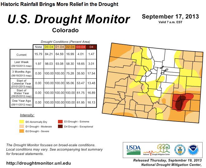
AFTER A VERY WARM AND DRY START TO SEPTEMBER…A WEATHER SYSTEM
MOVED INTO THE GREAT BASIN REGION BRINGING A PROLONGED PERIOD OF MOIST SOUTHERLY FLOW ALOFT TO THE STATE FROM 9TH THROUGH THE 15TH OF SEPTEMBER. THIS MOIST SOUTHERLY FLOW…COMBINED WITH MOIST LOW LEVEL UPSLOPE FLOW BEHIND PASSING COLD FRONTS ACROSS EASTERN COLORADO…BROUGHT EXTREME RAINFALL AND FLOODING TO COLORADO…ESPECIALLY ACROSS THE FRONT RANGE…SEPTEMBER 10TH THROUGH THE 13TH. WIDESPREAD RAINFALL OF 2 TO 6 INCHES WAS RECORDED ACROSS THE SOUTHWEST…CENTRAL AND SOUTHEAST MOUNTAINS…AS WELL AS SOUTHEASTERN BACA COUNTY. WIDESPREAD RAINFALL OF 3 TO 8 INCHES WAS RECEIVED ACROSS THE PIKES PEAK REGION…ALONG WITH POCKETS OF 10 TO 14 INCHES OF RAIN OVER THE FOOTHILLS OF WESTERN EL PASO COUNTY. WIDESPREAD RAINFALL OF 1 TO 3 INCHES WAS ALSO RECORDED ACROSS MOST OF THE REST OF SOUTH CENTRAL AND SOUTHEAST COLORADO…WITH LESSER AMOUNTS ACROSS PORTIONS OF THE LOWER ARKANSAS RIVER VALLEY. UNFORTUNATELY…THIS EXTREME RAINFALL ALSO CAUSED DEADLY AND DESTRUCTIVE FLOODING ACROSS PORTIONS OF THE AREA.
WITH THIS IN MIND…THE LATEST US DROUGHT MONITOR INDICATES AN END TO THE DROUGHT ACROSS WESTERN AND NORTHERN PORTIONS OF EL PASO COUNTY…EASTERN TELLER COUNTY…EASTERN FREMONT COUNTY…EXTREME NORTHWESTERN PUEBLO COUNTY AND LAKE COUNTY.
ABNORMALLY DRY (D0) CONDITIONS ARE NOW DEPICTED ACROSS SOUTH CENTRAL THROUGH NORTHEASTERN EL PASO COUNTY…NORTHWESTERN PUEBLO COUNTY…MOST OF CUSTER COUNTY…SOUTHWESTERN HUERFANO COUNTY…WESTERN LAS ANIMAS COUNTY AND EXTREME EASTERN COSTILLA COUNTY. ABNORMALLY DRY (D0) CONDITIONS ARE ALSO INDICATED ACROSS THE REST OF TELLER AND FREMONT COUNTIES…AS WELL AS MOST OF CHAFFEE COUNTY AND NORTHEASTERN SAGUACHE COUNTY.
MODERATE DROUGHT (D1) CONDITIONS ARE NOW INDICATED ACROSS MOST OF SOUTHEASTERN EL PASO COUNTY…CENTRAL AND SOUTHWESTERN PORTIONS OF PUEBLO COUNTY…THE REST OF HUERFANO COUNTY…CENTRAL LAS ANIMAS COUNTY AND MOST OF BACA COUNTY. MODERATE DROUGHT (D1) CONDITIONS ARE ALSO DEPICTED ACROSS WEST CENTRAL CHAFFEE COUNTY…THE REST OF SAGUACHE COUNTY…THE REST OF COSTILLA COUNTY…AS WELL AS ALL OF ALAMOSA…RIO GRANDE…CONEJOS AND MINERAL COUNTIES.
SEVERE DROUGHT (D2) CONDITIONS ARE NOW INDICATED ACROSS EXTREME SOUTHEASTERN EL PASO COUNTY…EASTERN AND SOUTH CENTRAL PORTIONS OF PUEBLO COUNTY…THE REST OF LAS ANIMAS COUNTY…NORTHWESTERN BACA COUNTY…EASTERN BENT COUNTY…PROWERS COUNTY AND EASTERN KIOWA COUNTY.
EXTREME DROUGHT (D3) CONDITIONS ARE NOW INDICATED MOST OF CROWLEY COUNTY…WESTERN OTERO COUNTY…WESTERN BENT COUNTY AND WESTERN AND CENTRAL PORTIONS OF KIOWA COUNTY.
EXCEPTIONAL (D4) DROUGHT CONDITIONS ARE NOW LIMITED TO SOUTHEASTERN CROWLEY COUNTY…EASTERN OTERO COUNTY…SOUTHWESTERN KIOWA COUNTY AND EXTREME WESTERN PORTIONS OF BENT COUNTY.
MORE INFORMATION ON THE US DROUGHT MONITOR CLASSIFICATION SCHEME CAN BE FOUND AT: WWW.DROUGHTMONITOR.UNL.EDU/CLASSIFY.HTM
SUMMARY OF IMPACTS…UPDATED
THE BENEFICIAL MONSOONAL RAINS OVER THE PAST FEW MONTHS HAVE PROVIDED RELIEF IN THE DROUGHT TO MUCH OF THE AREA…INCLUDING IMPROVEMENT IN CROPS AND VEGETATION…DECREASED FIRE DANGER AND THE LIFTING OR EASING OF WATER RESTRICTIONS.
THE SUMMER MONSOON…HOWEVER…HAS ALSO CREATED ITS OWN IMPACT WITH INCREASED FLASH FLOODING DANGERS…ESPECIALLY FOR AREAS IN AND AROUND RECENT BURN SCARS. SEVERAL DESTRUCTIVE FLASH FLOODS HAVE BEEN RECORDED SINCE JULY 1ST…ESPECIALLY ACROSS TELLER AND EL PASO COUNTIES…DUE TO THE LOSS OF VEGETATION AND THE DEVELOPMENT OF HYDROPHOBIC SOILS CAUSED BY THE RECENT WILDFIRES.
Rain totals have been tallied. But [Nolan Doesken] says a full picture of the flooding won’t be available for some time, making it difficult to compare the storm to other flash flooding events in Colorado. During this storm, rivers flowed with such intensity that stream gauges were damaged or destroyed.
Some of those other flooding events came after dry spells, Doesken said, and returned to drought not too long after.
“The lesson is, we don’t know what’s going to happen next. And there’s no guarantee that we’re out of the drought woods,” said Doesken.
The Front Range was drenched. The Western Slope wasn’t. Neither was the southeastern corner, a pocket of which is still categorized as being in extreme or exceptional drought.
“There’s now this concern that maybe we’re going to see more big rains and more flooding, but the reality is, that weather events happen and then we revert back to our regular seasonal cycles. With plenty of meteorological ups and down to go with it,” Doesken said.
Evans officials have inspected nearly 300 homes in the past two days, the majority of which have been deemed uninhabitable.
On Thursday, officials inspected 166 homes in the flood area. Seven homes had moderate damage and were given yellow tags. One home had little or no damage and was given a “green” tag. The remaining 159 residences, all within the Eastwood Village Mobile Home Park, were given orange tags, which means they have severe or complete damage. Orange tags mean the homes are uninhabitable and entering them carries the risk of death or injury. Earlier, inspectors had deemed 104 out of 112 inspected homes uninhabitable.
Thursday’s inspections continued as Evans officials announced they had begun erecting a security fence to protect property in a portion of the evacuated area. The fence will help prevent those who do not live in the area from accessing it. No one will be allowed to enter the fenced area between 8 p.m. and 7 a.m., according to a city of Evans news release.
The enclosed area is roughly bordered by Trinidad Street on the west, Ash Court on the north, a line across private property, which will enclose both the Bella Vista and Eastwood Village communities on the east, and about 39th Street on the south.
Residents will be admitted with proof of residency. Residents will be asked to get essential property as quickly as possible and then leave the area. Residents may enter at a checkpoint at 37th Street and Pueblo Street from 7 a.m. to 8 p.m.. Access also depends on the status of the property to be visited, the release stated.
Evans officials also announced on Wednesday that they plan to hold two meetings with residents to help keep residents informed. The meetings will take place at 2 p.m. Friday and 11 a.m. Saturday at the City of Evans Community Complex, 1100 37th St. in Evans. Residents with homes deemed unsafe are strongly encouraged to attend, according to the Evans news release.
“It is imperative that residents with homes that have been identified with yellow and orange tags attend one of the scheduled meetings,” the release stated. Officials from the city, Evans police and fire departments, FEMA, Weld County Department of Public Health, Red Cross, Weld County mental health services, Journey Church and the City of Evans Community Development Department will be on hand to answer questions, according to the release.
Jose Sandoval stood knee-deep in murky brown water on Wednesday several feet from his home, where floodwaters still flanked it on all sides.
“See where the water line is?” Sandoval said, pointing to a line of debris just a few inches from the roof of his home at Eastwood Village mobile home park in Evans.
As he pointed, his partner, Ruth Flores, waded up to their now-detached front porch, grabbed a lawn chair and set it against the window so that she could crawl in.
Sandoval had been to the home on Saturday, when he said the water was still chest-deep. He said he didn’t need to go in a second time.
“It’s ugly, ugly in there,” he said. “I’ve seen enough.”
Sandoval and Flores were some of the last people allowed to return to their flood-ravaged homes on Wednesday following the historic natural disaster that slammed Evans, east Greeley and other communities along the South Platte and Poudre rivers in Weld County.
Many lost everything. Some Evans residents on Wednesday stood in their front yards and spoke with their neighbors, while others tried to scrounge whatever they could from their homes.
At a community meeting held by Weld County commissioners Wednesday evening, questions abounded from displaced residents. The flurry of frustrations and concerns varied by the individual, but a central question hung over the heads of the more than 100 people there, as well as those standing helplessly by their destroyed homes: What now?
First and foremost, go to the disaster recovery centers, officials at the meeting said. There, displaced residents should find help from the likes of human services, North Range Behavioral Health, the Red Cross and FEMA. All of those affected by the flood qualify for assistance from FEMA and should register as soon as possible. The Greeley and Weld County housing authorities are gathering lists of landlords with any vacancies, and that information, too, is available at the disaster centers.
Weld County Commissioner Bill Garcia added that flood victims should also look to the faith-based community, namely Journey Christian Church in Greeley, for help.
Rick Hartman, a member of the Weld Faith Partnership Council, said 38 of the area’s church pastors have collaborated to make Journey their main point of contact.
So far, Weld County Commissioner Sean Conway said 685 people have passed through the disaster recovery centers set up in Greeley and the tri-town area. Of those, he said 550 have passed through the one in Greeley. Conway said reports of Boulder’s disaster recovery center show only 12 people passed through, and 10 have been helped in Adams County.
A humans relations representative with JBS USA said the company knows of 49 employees’ families who lost their homes completely.
Making progress
In Evans, Mayor Lyle Achziger said the city sent in a FEMA-certified team to search for people who may have been trapped in the mess and to analyze homes for their safety. All of those homes will be tagged, he said, with green, yellow or orange signs. The orange ones are not safe to live in or enter, he said.
Achziger said the no flush order has been helped greatly by Greeley’s assistance in pumping some sewage through a temporary line, and the 10-day limit is looking like it will come through.
“Folks, I think we’re going to make that,” Achziger said. “It might be tight.”
He said long-term, it looks as though the river has chosen a new course in a few places, which will take some engineering consultations.
In the meantime, he said the city will have to find a short-term fix — something Conway said is on the docket for many Weld County roads and bridges.
He said the county will focus on main roads used by the agricultural industry before fast-approaching harvest time, using whatever fixes are necessary to make those roads passable. Conway said the Colorado Department of Transportation has said it may be able to temporarily fill the section of U.S. 34 between Greeley and Kersey that dissolved in the flood.
Conway said the good news is the county has already repaired 10 roads that were flooded out, and road closures have dropped from 140 to 44. The county configured a map of alternate routes on its website for residents to consult before their commutes.
Commissioners also spoke about steps the county has taken to help flood victims, including unlimited vouchers for one truck full of waste to be taken to the landfill for free and a unanimous resolution commissioners passed earlier in the day that waives fees associated with reconstruction, like building permits and demolition fees, for those affected by the flood.
Fred Stenzel, who lives near LaSalle, stood up to say he had been lucky — he received “unbelievable” help from FEMA.
“There are all kinds of programs that can help you,” he encouragingly told those gathered at the community meeting. “We just have to be patient, and understand that the few of us in here, we are just a small percentage of those who were affected.”
No more tears
Earlier in the day on Wednesday, Flores wasn’t sure she would make it in to see her home.
She was wearing sandals — now the only shoes to her name — when she fled her home on Friday and needed boots to get to the far back corner of the mobile home park, where her family lived.
She and Sandoval ventured through the neighborhood to see how far she could make it in sandals, passing a mud-crusted stroller left in the street, fences folded in on themselves, and abandoned cars.
The neighborhood smelled at times like a lake, at other times a sewage plant. Mosquitoes buzzed over pools of standing water and, in the distance, maintenance workers silently worked on damaged infrastructure under an intense September sun.
“Oh, God, this is chaos,” Flores said. “I don’t even smoke, and I feel like smoking.”
Sandoval pointed to a ravaged home next to him.
“We were just going to do the roof on that, too,” Sandoval said of his work as a roofer. “We had the contract lined up and everything.”
Later, Flores emerged from the couples’ home with little good news. Their five kids, ages 5, 6, 7, 9 and 13, would be disappointed — the Xbox didn’t make it.
“I told my son, put your stuff high up, we’ll be back for it,” Sandoval said.
Flores said her collection of coveted Coach purses were destroyed. It might not even be worth the trip to get the few things that did survive the flood, she said.
“Your orange Converse are good,” Flores shouted to Sandoval from her perch outside of the window. “The bathrooms are both full with (expletive) mudwater.”
Shortly after the pair ventured back from the wreckage, crews dressed in wader pants began knocking on the doors of the mobile homes to be sure no one was trapped inside. Several National Guard trucks lined up on 37th Street, and firefighters stood ready to rinse off the boots of those who trekked through the contaminated water.
Roderigo Corral looked on as they methodically posted bright orange signs on every front door on his street.
“Unsafe. Do not enter or occupy,” they said.
Corral and his mother-in-law sat in their garage, beside heaps of ruined clothes, furniture and housing supplies that they dragged outside. The tree in Corral’s front yard in Riverside Park, just off of 37th Street, had been uprooted and lay across his driveway.
“Everything is gone,” he said.
Every few minutes, a few more people emerged from their homes with a singular box or container, walking silently from their old homes — some for the last time.
Through it all, Flores and Sandoval maintained relatively good spirits. Sandoval even teased Flores as she struggled to conquer a fence and get back to him.
“I gotta get a video, I gotta get a video,” he said, laughing.
Sandoval said Wednesday was a time to see what remained. If the flood took everything, then it’s time to pick up, and move on, he said.
The biggest concern for the city [Thornton] is the breach of one of its 12 dams along the South Platte River, said Emily Hunt, the city’s water resources manager.
“We had flood water overtop five of (the berms) — with one of the five, we had a complete failure of the berm so there’s no separation between the reservoir and the river right now,” she said.
The city isolated the reservoirs, and because the city has multiple water resources the drinking water has not been compromised, Hunt said.
Repairing the breached berm will take six to 12 months and is the top priority for the city. It could take between 18 to 24 months to repair the erosion on the other berms.
The flooding in other parts of the city occurred from overflowing streams, backed up sewers and gutters and detention ponds at full capacity and overflowing “Too much rain in such a short period of time left nowhere for the water to go,” [Brett Henry] said…
The city did lose the pedestrian bridge over Grange Hall Creek, and experienced erosion in multiple areas — including losing a portion of the shoulder on 128th Avenue west of Riverdale Road, which exposed a gas line, sewer manhole and a communications conduit — but no roads were lost, he said.
Meteorologists predict that river levels across Weld County will continue to drop, slowly but surely over the next few days, and the receding floodwaters have allowed officials to assess and begin to repair damage.
The Poudre River, which peaked at 8.8 feet, is now well below the 8-foot flood stage. Exact levels of the South Platte and St. Vrain rivers are unavailable , since flood waters took out the gauging system, but water levels on both have been dropping and are expected to drop 6 inches per day, said David Barjenbruch, National Weather Service meteorologist.
“They’re still running high, but we’re getting there,” Barjenbruch said, adding that there are mostly dry days ahead.
As waters recede, officials are getting a better look at widespread damage to highways and roads. County and state crews have already begun repairs on roadways they can reach.
In the county, bridge, culvert and pavement crews have been assessing and repairing damage for days. Jennifer Finch, spokeswoman for Weld County, said crews are prioritizing roads that are important to both commuters and farmers.
“It’s also important that we look at the roads that our agriculture producers need to use because it’s harvest season and that stuff is timely,” Finch said.
Still, Finch said, getting travel routes back to normal will be a very long process.
“(Road and bridge crews) also have to be safe, so they’re doing a good job of not rushing it,” Finch said. “We have to be smart about our roads.”
Barriers still in place are there for a reason, Finch said. Some roads may look OK on the surface but could have underlying safety issues.
“That road could give way at any time, but you don’t know standing on top of the road,” Finch said.
While roadways in the county continue to open back up, there’s no such luck for drivers hoping to use U.S. 34 east of Greeley. Colorado Department of Transportation crews were bringing in heavy equipment and assessing the damage on Thursday morning.
They’re working on a plan to build a temporary roadway north of the gaping hole that would remain through the winter months, said CDOT spokesman Bob Wilson. Crews would start long-term construction on the old route in the spring, he said.
“We don’t have any time lines at this point,” Wilson said.
County road closures have inundated major highways, like U.S. 34, Interstate 25 and U.S. 85, with traffic. Officials recommend checking the CDOT and Weld County websites for alternate routes. For example, Wilson suggested taking Colo. 392 or Colo. 14 into Fort Collins, and Colo. 66 into Longmont. Wilson said many state roadways that are closed in the mountains are just fine along the Front Range.
“I know people are frustrated,” Finch said. “We’re all frustrated. We’re all dealing with having to find new ways to get places.”
Evans inspectors have worked to evaluate homes in evacuation areas, the majority of which have been deemed unlivable.
The evacuation order remains in place, as does a curfew from 10 p.m. to 6 a.m. in those areas. The no-flush order is also still in effect, as Evans officials work on their plan of pumping some waste through Greeley’s treatment system, though officials say they’re making progress.
Trash pick up in the city will resume as normal on Tuesday.
Finch said inspections have also been completed on some buildings in the county but, of the relatively few homes flooded in unincorporated Weld, most have been deemed OK to live in.
Flood waters also did a number on the Union Pacific Railroad line between LaSalle and Fort Collins. Mark Davis, spokesman for the railroad, said much of the track around the South Platte is still under water, and crews are hoping to get a better look over the next few days.
“Water is still up over there, and we don’t know when that’s going to drop,” Davis said.
Greeley residents may notice rail cars with giant boulders chugging through on the line that runs from Cheyenne to Denver. Davis said those boulders are headed to the mountains to repair major damage to the line from Denver through Moffat on the way to Grand Junction.
With no more flood-related evacuations or rescues anticipated, the county is hard at work in the recovery stage, offering residents services at two recovery assessment centers, one in Greeley and the other in the Tri-Town area. Finch said county officials are doing all they can to get people back in their homes and back on their normal routes, but that process will be much slower than the speed at which floodwaters caused unprecedented damage.
“The recovery is happening, but’s it’s not going to happen at that same pace,” Finch said.
On Wednesday, energy operator Anadarko Petroleum identified a tank that released “condensate,” which is a mixture of light oil and water, into the South Platte River near Milliken. According to COGA, a flow-line pipe used to carry condensate between equipment and the storage tank was compromised by silt and debris that broke the line between tanks. Anadarko Petroleum pumped the remaining condensate from the storage tank and put absorbent booms into the water.
Another Anadarko tank released more than 13,000 gallons of oil into the St. Vrain River in Firestone. COGA says it was also due to a compromised pipe.
According to Doug Flanders, COGA’s Director of Policy, the spills were immediately reported to the National Response Center, Environmental Protection Agency (EPA), Colorado Department of Public Health and Environment, Colorado Oil and Gas Conservation Commission (COGCC) and Weld County Local Emergency Planning Committee. He said containment and clean-up efforts were immediately initiated, with oversight from the EPA, COGCC and CDPHE.
Flanders says fracturing fluid additives were not released into the rivers. “These chemicals are not stored on producing well sites,” Flanders said…
At least eight other minor oil spills have been reported throughout the state. Six teams from the state are also doing their own inspection of the wells. The industry estimates that only about 10 percent of the wells in the worst hit areas have yet to be assessed.
From the Associated Press via The Pueblo Chieftain:
Colorado’s flooding shut down hundreds of natural gas and oil wells in the state’s main petroleum-producing region and triggered at least two spills, temporarily suspending a multibillion-dollar drilling frenzy and sending inspectors into the field to gauge the extent of pollution. Besides the possible environmental impact, flood damage to roads, railroads and other infrastructure will affect the region’s energy production for months to come. And analysts warn that images of flooded wellheads from the booming Wattenberg Field will increase public pressure to impose restrictions on drilling techniques such as fracking.
“There’s been massive amounts of growth in the last two years and it’s certainly expected to continue,” Caitlyn McCrimmon, a senior research associate for Calgary-based energy consultant ITG Investment Research, said of Colorado oil and gas drilling. “The only real impediment to growth in this area would be if this gives enough ammunition to environmentalists to rally support for fracking bans, which they had started working on before this.”
Two spills were reported by Anadarko Petroleum Corp. — 323 barrels (13,500 gallon) along the St. Vrain River near Platteville, and 125 barrels (5,250 gallons) into the South Platte River near Milliken, federal and state regulators said. The St. Vrain feeds into the South Platte, which flows across Colorado’s plains and into Nebraska. In both cases, the oil apparently was swept away by floodwaters. Both releases involved condensate, a mixture of oil and water, said Environmental Protection Agency spokesman Matthew Allen.
The environmental damage still was being assessed, but officials in Weld County, where the spills took place, said the oil was just one among a host of contaminants caught up in floodwaters washing through communities along the Rocky Mountain foothills.
The Colorado Oil and Gas Conservation Commission (COGCC) said Thursday it received reports of 10 releases of oil as of noon. “Two of those are notable; the remaining eight appear to be minor,” the COGCC said in a statement. Both of the major spills come from equipment operated by Anadarko Petroleum Corp., the COGCC said…
“In both cases, it appears the oil left the site in floodwaters,” the state said.
By comparison, the combined total amount released in the two larger spills reported to date — nearly 19,000 gallons — is just a bit less than the amount of water flowing past the U.S. Geological Survey’s gauge every two seconds on the South Platte River outside of Fort Lupton. The gauges measured about 10,000 gallons of water per second flowing down the South Platte River outside Fort Lupton Thursday — more than 10 times the average, according to the USGS’s stream flow data That’s down from about 67,000 gallons per-second passing the same gauge at the peak water flow during the flooding Sept. 12-14, according to the USGS.
State regulators spent Thursday following 10 reported spills from oil and gas facilities throughout Weld County, including two that dumped almost 19,000 gallons into the floodwaters.
The state Department of Natural Resources reported 10 total, but eight were classified as minimal on Thursday. Operators throughout the area will continue inspecting their own facilities until the waters recede, all under the close eyes of the Colorado Oil and Gas Conservation Commission, the state Department of Health and Environment, and the Environmental Protection Agency.
“In the context of this historic event, these spills are not an unexpected part of many other sources of contamination associated with the flood,” said Todd Hartman, spokesman for the state Department of Natural Resources, which oversees the COGCC. “Those include very large volumes (millions of gallons) of raw, municipal sewage and other hazards associated with households, agriculture, business and industry.”
The 19,000 gallons is the equivalent of about .06 of 1 acre-foot, which is the amount of water covering one acre to a depth of 1 foot, or 326,000 gallons. The Wattenberg field on average produces 5.6 million gallons (134,333 barrels) of oil per day.
“This storm was simply a massive natural disaster,” said John Christiansen, spokesman for Anadarko Petroleum Corp. in Denver. “I don’t know that anyone could have predicted” the destruction.
Mark Salley, a spokesman for the Colorado Department of Public Health and Environment, said it’s too soon to determine what the environmental impact of the spills may be, but he said oil and gas isn’t the only concern.
“There have been millions of gallons of raw sewage released to the waters, and that’s a greater focus as far as public health is concerned,” Salley said.
The spilled oil, called light condensate, had long since washed down the river once it was discovered, industry officials said. They were able to suck up through a vacuum some remaining condensate in one of the tanks.
The two sites, one south of Milliken and the other near Firestone, were relatively new wells drilled in the flood plain. They were designed with fencing and equipment reinforcements to withstand flooding — but not a 1,000-year flood, said Korby Bracken, director of environmental health and safety at Anadarko in Denver.
Crews discovered both of the spills late Wednesday, based on visual inspections and electronic data. One was a 5,250-gallon spill from a storage tank south of Milliken near the confluence of both the South Platte and St. Vrain rivers. Another tank has released 13,566 gallons near Firestone along the St. Vrain.
“In both cases, it appears the oil left the site in floodwaters,” according to a statement issued by Hartman. “Though Anadarko deployed absorbent booms in the first case, the booms collected residual oil in standing water pooled around the tanks (not water feeding into the river). In both cases, the releases were promptly reported by the operator.”
Anadarko officials said the damage to the tanks was caused by rushing debris cracking flow lines into the storage tanks. Anadarko officials on Thursday said they have deployed 150 people on the ground and in the air to assess critical oil and gas sites. Most of their sites remain intact, but are littered with debris and sediment, Bracken said.
Anadarko and other large operators in the Wattenberg Field worked in earnest to shut in their wells and empty their storage tanks prior to the flooding, but few knew just how far the waters would swell.
Bracken said Anadarko crews began shutting off production and emptying tanks along the flood plain last week. The two tanks that spilled were not emptied.
“They just weren’t facilities we thought were going to be impacted,” Bracken said. “We’re looking at a major disaster. We addressed the high priority ones, out of the 2,500 tank batteries we had in the basin, with two issues identified. We like to see zero.”
Hartman reported that the eight remaining minor spills “would be considered spills described as sheens coming off of a piece of equipment rather than a measurable volume of petroleum product.”
A typical oil storage tank holds 300 barrels, though some tanks are larger. The two releases from Anadarko involved approximately one and one-half tanks.
Though officials have pinpointed specific sites of concern, Bracken said it was too soon to tell if there were other Anadarko facilities that were compromised, but inspections will continue as the waters recede. Some sites are still not accessible due to floodwaters or road closures. Crews have been surveying from the air, and using amphibious vehicles to get to all 675 sites in the flood plains, Bracken said.
Six teams of regulators were on the ground Thursday doing inspections, with two surveying by air.
Noble Energy noted late Wednesday that they had identified three releases of minor natural gas leaks, and two wells were shut in. A third release, the company reported, remained inaccessible due to floodwaters.
Encana Corporation, conversely, has been able to inspect all of its facilities, with now a total of 133 wells shut in and all 424 tank batteries inspected, with no reportable leaks as of Thursday, reported Doug Hock, spokesman for the company.
A federal decision on the Southern Delivery System is headed to court. The Lower Arkansas Valley Water Conservancy District is preparing a complaint to file in federal court over the Bureau of Reclamation’s refusal to reopen its record of decision on SDS. The central issue is the abolishment of the Colorado Springs stormwater enterprise in 2009, which was in place when Reclamation granted approval of a 40-year contract for storage, exchange and connection at Pueblo Dam for SDS.
“I’m asking our board to draft a legal complaint against the Bureau of Reclamation,” said Melissa Esquibel, a Pueblo County board member. “We’ve asked the Bureau of Reclamation to reopen the record of decision, and gotten no action. We need to direct staff to draft a lawsuit.”
Lower Ark board members say SDS should not be allowed to deliver water until the stormwater issue is resolved. “If there had not been a stormwater enterprise, SDS never would have gotten a 1041 permit,” said Anthony Nunez, a Lower Ark board member who was a Pueblo County commissioner in 2009.
Last year, the Lower Ark district sent letters to Reclamation asking to reopen the record of decision on the stormwater issue. Reclamation declined to take any action.
This will be the second lawsuit the Lower Ark district has filed against Reclamation, if the board approves it at its October meeting. In 2007, the Lower Ark sued Reclamation over a 40-year storage and exchange contract with Aurora, claiming it illegally allowed the Fryingpan-Arkansas Project to move water out of the Arkansas River basin. The lawsuit was settled in 2009, after Aurora and the Lower Ark signed an agreement for mitigation of some of the issues surrounding the contract.
Flood protection for the Lower Arkansas Valley should not be an afterthought. That message was delivered to Colorado Springs Wednesday during a presentation about regional stormwater efforts in El Paso County to the Lower Arkansas Valley Water Protection District. “We quibble about data. What I want to see is the problem fixed,” Lower Ark General Manager Jay Winner told Mark Pifher, point man for the Southern Delivery System.
Colorado Springs Utilities disputes the Lower Ark’s interpretation of state and federal data about water quality. The Lower Ark claims it shows higher flows have increased sedimentation and bacteria in Fountain Creek since Colorado Springs got rid of its stormwater enterprise in 2009. Pifher countered that’s just because of higher peak flows in the past three years. Fountain Creek monitoring has begun and safeguards are built into the Bureau of Reclamation’s contract through an adaptive management program if unexpected pollution occurs, he said. A stormwater task force and Mayor Steve Bach are close to coming to consensus and moving a stormwater issue to the 2014 ballot.
All of which served to aggravate Pueblo County members of the Lower Ark board:
“My heartburn is that the discussions center around the Black Forest and Waldo Canyon as far as Fountain Creek is concerned, but nothing for us” said Melissa Esquibel. “I don’t think anything substantive has happened.”
“It’s been a fractured thing up there since I was a commissioner. It almost doesn’t seem real. We’ve heard the same thing over and over and over,” said Anthony Nunez. “I have to say there is a small amount of trust.”
“We have to put limits on SDS until the stormwater issue is taken on,” said Reeves Brown.
Colorado Springs voters defeated a Doug Bruce measure in 2008 to make payment of stormwater fees voluntary by 30,000 votes, but City Council abolished the stormwater enterprise after a second ballot measure that did not even mention it by name passed in 2009, Winner said. While Bruce campaigned against a “rain tax,” the 2009 Proposition specifically tried to sever utility payments from the Colorado Springs general fund. Council has not ended Utilities payment in lieu of taxes, Pifher said in response to a question by Winner.
Pifher said stormwater fees would be collected again beginning as soon as 2015 if voters approve it in 2014. That didn’t do much to allay fears. “You got what you needed and the stormwater enterprise went away,” Winner said. “Do you see the pattern here?”
More Southern Delivery System coverage here and here.