
"the planners’ joke – there are two things that residents hate: sprawl and density" http://t.co/CyFAENDRbZ via @Cocolaboca
— jfleck (@jfleck) September 19, 2013
Day: September 29, 2013
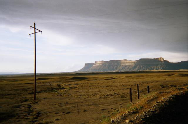
Green River Basin: Utah may get its first nuke electrical generation plant if the water is there #ColoradoRiver
From the Deseret News (Amy Joi O’Donoghue):
The fate of a proposed nuclear power plant — the first in Utah — turns on the ebb and flow of the Green River, where proponents of the project want to divert water to cool the plant’s nuclear reactors.
For five days in a small courtroom in Price last week, Judge George Harmond — who once served on the Utah Board of Water Resources — listened to reasons why the decision to grant that water for the plant was within the law or, alternately, why it contravened the statute governing water allocations.
Ultimately, whatever the 7th District judge decides — he took the case under advisement and will issue a decision within 60 days — the loser in this contest is destined to appeal.
I wonder what is different in the new designs that makes them require less water than Fukushima Daiichi did. It seems to me that it requires unlimited volumes of water when you are fighting for control of a fission reaction. That sort of supply is not apparent in the landscape near the reactor site.
Oil shale: Shell’s exit from the game does not worry companies left standing #ColoradoRiver
From The Grand Junction Daily Sentinel (Dennis Webb):
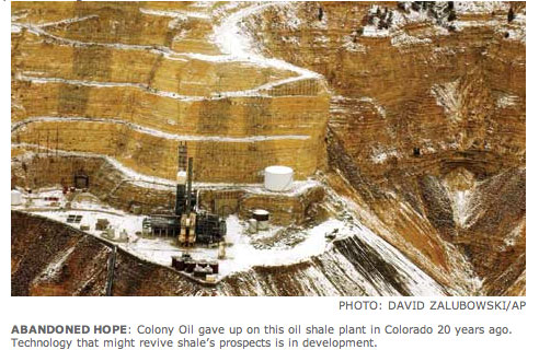
Some companies pursuing oil shale projects in Colorado and Utah voiced confidence in their efforts Wednesday even as they absorbed the news that Shell is shutting down its undertaking in Rio Blanco County.
Among them is American Shale Oil LLC, which holds a federal research, development and demonstration lease in Rio Blanco County and is working to develop oil shale in-situ, meaning in place underground. “AMSO’s still committed to its project. We still believe (oil shale) is a viable resource using our approach” to develop it, said Claude Pupkin, chief executive officer of Genie Energy, which owns a 50 percent interest in AMSO.
In northeastern Utah, Red Leaf Resources continues to move “full-speed ahead” with its project, with the next goal being a commercial demonstration of its surface-mining and processing approach to develop oil shale, said CEO Adolph Lechtenberger.
“Everything we look at in our technology says it’s certainly economic at today’s oil prices,” he said.
Shell said this week it is ending its in-situ Colorado oil shale project, which it began in 1996. Shell has been a leader in oil shale research in the region and owns three federal RD&D leases in Rio Blanco County. Shell said it had decided to focus on other opportunities and assets in its global energy portfolio, including oil shale projects in Jordan and Canada.
Last year, Chevron, which also holds a federal RD&D lease in Rio Blanco County, also said it was ending its oil shale project.
ExxonMobil, which recently was granted a federal RD&D lease in Rio Blanco County for an in-situ project, declined to react to Shell’s decision, saying it doesn’t comment on the activities of other companies. But spokesman Patrick McGinn said it is continuing lab-based work on its process.
Different barrel of oil
ExxonMobil is hoping to fracture shale, fill fractures with conductive material and then heat the shale with an electric charge to produce oil. “We are concentrating our efforts on developing additional improvements in thermal and electrical process efficiency to further improve the economic and environmental factors of any commercial development.
“Field experiments to test new developments could be conducted at either (the company’s Parachute-area) Colony Mine or the ExxonMobil RD&D lease in Rio Blanco County. We do not anticipate field tests in 2013,” he said by email.
Lechtenberger said it’s unfortunate to see a player of Shell’s size pull out of Colorado. “They’ve done a lot of good work over the years and made pretty good strides,” he said.
But he added, “I think we’re going after a different barrel of oil than Shell was going after.” Shell was targeting shale deep underground, he noted.
“Our technology is going after shale closer to the surface, easier to mine, with a lower cost to remove,” he said.
Enefit also is working on a surface shale project in Utah. Lechtenberger said he thinks the deeper-shale projects in Colorado “are going to be a challenge. I think they’re going to be capital-intensive and they’re going to take good technology to do it.”
Companies pursuing the in-situ process in Colorado are targeting the heart of what is the world’s largest oil shale resource and extends into Utah and Wyoming. They also say their approach will result in fewer surface impacts.
AMSO has been working through some challenges with heaters for its project and is currently evaluating alternative heaters it can use.
Pupkin said it’s important to note that Shell isn’t pulling out of oil shale altogether. “They have a very active project ongoing in Jordan and our understanding is that it’s because Jordan not only has very attractive oil shale but they’ve put in place a regulatory framework that makes investment projects capital-attractive,” he said.
Regulatory uncertainty
Jeremy Boak, director of the Center for Oil Shale Technology and Research at the Colorado School of Mines, said the last he heard Shell has more than 200 people working on oil shale in Jordan. Worldwide, it has spent hundreds of millions of dollars on oil shale, he said. “They’re clearly not abandoning oil shale as a concept. They’re just deciding that Colorado is not the place they want to do it right now even though it’s (home to) the world-class resource.”
Pupkin said he thinks the regulatory uncertainty related to the Bureau of Land Management’s changing position regarding royalties and other oil shale rules contributed to Shell’s decision. Shell has voiced concern over that uncertainty in the past but didn’t specifically cite it this week.
The BLM also has sharply reduced the amount of land potentially available for oil shale leasing in the three-state region, and particularly in Colorado. “We think that the Obama administration has taken a pretty negative approach towards oil shale,” Pupkin said.
Jeff Hartley of Red Leaf Resources noted that his company doesn’t face the constraints Shell faced with BLM lands because it is working on school trust lands instead.
Viable technologies
Chevron spokeswoman Cary Baird said she doesn’t believe her company raised regulatory concerns as an issue when it made its oil shale decision. Rather, it was just a matter of prioritizing what opportunities to invest financial and human resources in at a global level, she said, somewhat echoing Shell’s reasoning. “There are difficulties occasionally in getting good, qualified people to work on different projects and when you have a global portfolio it makes it more complicated,” she said.
Shell’s decision comes as companies are using hydraulic fracturing to produce growing amounts of natural gas and oil. Shell just this week identified a location for a $12.5 billion natural-gas-to-liquids facility it hopes to build in Louisiana.
“When you compare the challenge of oil shale to the viability of these other sources, Shell like Chevron decided to place their focus on viable technologies and viable business models,” said David Abelson, oil shale policy advisor for the Western Resource Advocates conservation group. He said he wasn’t surprised by Shell’s announcement, and that it’s learned what other companies have learned over a century about the “extremely challenging” economics of developing oil shale.
“Shell has always said that this is a research project and they always talked about it being a heavy lift to create a viable fuel and what they learned is what Chevron learned,” he said.
He said Shell hasn’t been among the strongest boosters of oil shale. “It was the elected officials that got ahead of Shell and claimed the viability of these technologies,” he said.
Workshop: The Colorado Basin Roundtable and the Governor’s Statewide Water Plan #ColoradoRiver
From email from the Middle Colorado Watershed Council:
The Middle Colorado Watershed Council is excited to host an informational workshop [September 24] that will explore the opportunities for information exchange and integration between several important and timely water resource planning efforts currently underway. The afternoon’s panelists will include:
Jim Pokrandt, Communication and Education Specialist with the Colorado River District and Chair of the Colorado Basin Roundtable;
Louis Meyer, President and CEO of SGM Inc., Garfield County’s representative on the Colorado Roundtable, and Consultant to the Roundtable for development of the Basin Plan; and
Ken Neubecker, Executive Director of the Western Rivers Institute and the Environmental Representative on the Colorado Basin Roundtable
Topics the speakers will cover include:
History of the Roundtable and its function What the Statewide Water Plan intends to accomplish and how it will use information generated through the Roundtable process Findings of the Roundtable analyses specific to the Middle Colorado River
Projects identified to date and opportunities for generating new projectsOpportunities for information exchange, integration and collaboration between watershed-based, regional and statewide water resource planning efforts The presentations will be followed by an open forum providing opportunity for Q&A as well as public input and feedback.
More Colorado Water Plan coverage here.
Drought news
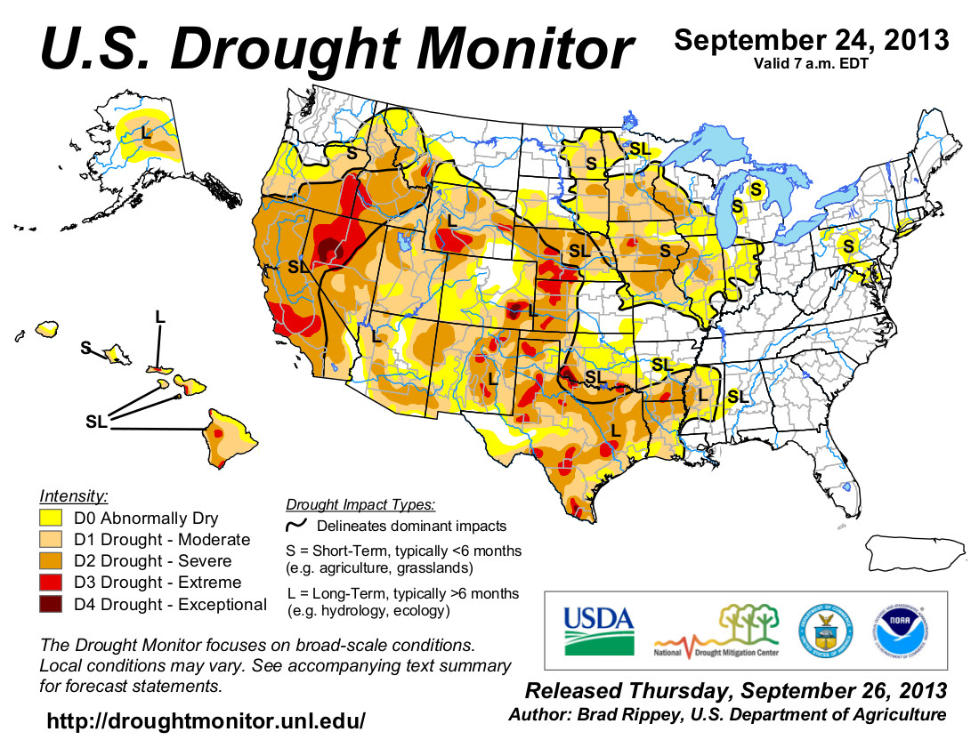
From the US Drought Monitor discussion September 24, 2013:
Weather Summary: Rain lingered in parts of Colorado and neighboring states for a few days in the wake of historic flooding, but mostly dry weather thereafter allowed recovery efforts to progress. However, a flood crest on the South Platte River coursed through northeastern Colorado and southwestern Nebraska, inundating some agricultural lowlands. Meanwhile, the tropical plume of moisture partially responsible for Colorado’s flooding shifted eastward in advance of a cold front. As a result, 1- to 3-inch rainfall totals were common along and east of a Wisconsin-to-Texas line. The rain temporarily halted fieldwork, including harvest activities and winter wheat planting, but aided some late-developing summer crops. Even heavier rain, locally 4 inches or more, curtailed fieldwork but eased drought from central and eastern Texas to the Mississippi Delta. Elsewhere, generally dry weather across the Southwest and the northwestern half of the Plains contrasted with scattered showers from the Pacific Northwest to the northern Rockies. The weather change in the Southwest signaled the end of the summer rainy season, while dry weather on the northern Plains promoted winter wheat planting and other fieldwork…
The Great Plains: Like the Midwest, varying amounts of rain dampened the Great Plains. Heavy rain soaked much of the southeastern half of Texas, while another significant rainfall event drenched northeastern Colorado and neighboring areas. Both areas saw substantial reductions in drought coverage and intensity. However, little or no rain fell in several other parts of the region. In the heart of Colorado’s flood zone, an official observation site in Boulder received 16.69 inches of rain during the first half of September. Boulder’s previous wettest month had been May 1995, when 9.59 inches fell. According to emergency operations reports, Colorado’s flooding claimed seven lives, destroyed nearly 1,900 homes, and damaged more than 16,000 others. Meanwhile, month-to-date precipitation climbed to 6.80 inches in Cheyenne, Wyoming, most of which (5.80 inches) fell from September 9-16. Prior to this year, Cheyenne’s wettest September had occurred in 1973, when 4.52 inches fell. In Nebraska, a record-setting crest on the South Platte River passed Roscoe (3.20 feet above flood stage) on September 20, and arrived 3 days later in North Platte (1.36 feet above flood stage). Previous high-water marks had been observed in June 1995 at Roscoe and in June 1935 at North Platte. The Platte River at Brady, Nebraska, crested 3.23 feet above flood stage on September 23, surpassing the May 1973 high-water mark by more than a foot. Despite all of the rain, rangeland and pastures across some parts of the Great Plains continued to suffer from the cumulative effects of multiple drought years. On September 22, rangeland and pastures were rated at least one-third very poor to poor several states, including Texas (54%), Colorado (43%), Nebraska (40%), and Kansas (36%).
The West: With the 2013 summer rainy season having ended across the Southwest in mid-September, further assessment of the robust monsoon led to additional reductions in drought coverage and intensity in the Four Corners States. In southeastern Arizona, Douglas experienced its greatest monsoon season rainfall on record, with 16.24 inches of rain having fallen from June 15 – September 24. Several other parts of Arizona also experienced near-record to record summer rainfall totals. Farther north, some early-season precipitation from winter-like storms began to arrive in northern and central California and the Northwest. For example, daily-record rainfall totals were noted on September 21 in locations such as Redding, California (1.22 inches), and Roseburg, Oregon (0.56 inch). No changes in the drought depiction were yet introduced in the Northwest, but the region will be monitored as precipitation continues to spread inland. Nevertheless, precipitation is beneficial for newly planted winter wheat, which by September 22 was 59% planted in Washington…
Looking Ahead: An early-season snow storm will wind down on September 26-27 across the northern Rockies, while rain showers will gradually end in the Southeast. Meanwhile, a slow-moving cold front—and its associated surge of cold air—will reach the nation’s mid-section toward week’s end before weakening. A frontal remnant will move into the South and East early next week, while Pacific energy will arrive in the Northwest. Associated with the cold front, late-week precipitation totals of 1 to 2 inches can be expected across portions of the nation’s mid-section. Starting on September 27, heavy precipitation (locally 4 to 8 inches or more) will develop in the Pacific Northwest.
The NWS 6- to 10-day outlook for October 1-5 calls for near- to above-normal temperatures nationwide, except for cooler-than-normal conditions in a small area centered on the Four Corners region. Meanwhile, near- to below-normal precipitation across the majority of the U.S. will contrast with wetter-than-normal weather in the Pacific Northwest and a broad area stretching from the Gulf Coast into the lower Great Lakes region.
From The Colorado Springs Gazette (Garrison Wells):
“There will be some improvement across the area, but we are still well below normal,” said Mark Wankowski, meteorologist with the National Weather Service in Pueblo. The wet fall, he added, is no indication that this winter will produce more snow than last year, he added.
“There is no correlation between a wet fall and wet winter,” Wankowski said. “Forecast for the winter is that there is an equal chance of below, above or near-normal precipitation. Basically, it’s up in the air.”[…]
Beating drought in El Paso County depends on mountain snowfall, [Kathy Torgerson] said. And what happens in the mountains this winter will be measured storm by storm. “There’s really no strong signal to drive it one way or the other,” Torgerson said.
Colorado Springs Utilities project: Pikeview to Mesa construction
From Colorado Spring Utilities:
In late September 2013, we started construction on a drought mitigation project that will have the ability to deliver an additional 8 million gallons of water a day to customers next spring. The initial phases of the project will include lane restrictions on West Fillmore Street.
The $8 million pipeline project will connect the Pikeview Reservoir, near I-25 and Garden of the Gods Road, to the Mesa Water Treatment Plant, near Mesa Road and Fillmore Street. The effort will enable us to maximize water rights in Monument Creek, and further insulate customers from existing and future droughts.
As part of the project, we will install a 24-inch diameter, raw water pipe underneath portions of West Fillmore Street, Chestnut Street, Ellston Street, Sinton Road, Sutton Lane and Interpark Drive.
Pipe installation will occur on Fillmore in two phases. The first phase, which began at the end of September, will include work between Centennial Boulevard and Grand Vista Circle, while the second phase will be between Sage Road and Centennial Boulevard.
Lane restrictions will be in effect for the impacted portions of Fillmore during construction. Heading west on Fillmore, traffic will be reduced to two through lanes, while eastbound traffic will be reduced to one through lane. Depending on construction activities, lane restrictions may vary. Alternate routes are strongly advised.
The drought mitigation project will not impact recent Pikes Peak Regional Transportation Authority roadwork near Fillmore and I-25. However, we will continue to coordinate construction efforts with PPRTA and the City of Colorado Springs.
More infrastructure coverage here.
Denver Water sets course for 2014
From Denver Water:
Like utilities across the nation, Denver Water faces the challenge of staying on top of maintenance for its aging system — some of which was built more than 100 years ago — to ensure area residents continue to receive high-quality water and reliable service year-round, 24 hours a day, 7 days a week.
At its meeting today, the Denver Board of Water Commissioners adopted a budget and rate changes to fund essential repairs and upgrades in 2014.
The 2014 budget is $371 million, which will fund a number of multi-year projects, such as replacing aging pipes and failing underground storage tanks, upgrading water treatment facilities to maintain water quality and meet new regulatory requirements, and rehabilitating Antero Dam. The budget is funded by water rates, bond sales, cash reserves, hydropower sales and fees for new service (tap fees).
Effective January 2014, the budget calls for a rate increase of $1.29 per month on average for Denver residential customers and full-service suburban residential customers using 115,000 gallons annually (the average annual consumption for Denver Water’s service area). The amounts will vary depending upon customer water usage and whether the customer lives in Denver or is served by a suburban distributor under contract with Denver Water. Customers in Denver tend to use less than 115,000 gallons per year; suburban customers tend to use more.
“We continue to prepare for Colorado’s increasingly extreme and unpredictable weather cycles, which require us to do all we can to make sure our system is even more resilient,” said Jim Lochhead, CEO/manager of Denver Water. “In response to the dry conditions earlier this year, we prepared financially by reducing our 2013 operating expenses, deferring projects and tapping into our cash reserves to help reduce our costs and balance our finances.”
“We adjust our budget and corresponding water rates each fall for the following year after we examine the necessary projects needed to maintain and upgrade our system.”
Denver Water operates and maintains more than 3,000 miles of distribution pipe — enough to stretch from Los Angeles to New York — as well as 19 raw water reservoirs, 22 pump stations and four treatment plants.
“Denver Water’s collection system covers more than 4,000 square miles, and we operate facilities in 13 counties in Colorado,” said Lochhead. “It takes an extensive network of pipes, pump stations, treatment plants, people and more to make sure our customers can turn on the tap and enjoy fresh, clean, safe water every day. We must continue to invest in that system to ensure a secure water supply for the future.”
Under the 2014 budget, rates for Denver Water customers living inside the city would remain among the lowest in the metro area, while rates for Denver Water residential customers in the suburbs would still fall at or below the median among area water providers.
The water department is a public agency funded by water rates and new tap fees, not taxes. Water rates are designed to recover the costs of providing water service — including maintenance of distribution pipes, reservoirs, pump stations and treatment plants — and also encourage efficiency by charging higher prices for increased water use. Most of Denver Water’s annual costs are fixed and do not vary with the amount of water sold.
‘Climate change … requires urgent action, not tomorrow but today’
USGS: Chemistry and Age of Groundwater in the Piceance Structural Basin #ColoradoRiver

Click here to read a copy. Click here for the release. Here’s the abstract:
Fourteen monitoring wells were sampled by the U.S. Geological Survey, in cooperation with the Bureau of Land Management, to better understand the chemistry and age of groundwater in the Piceance structural basin in Rio Blanco County, Colorado, and how they may relate to the development of underlying natural-gas reservoirs. Natural gas extraction in the area has been ongoing since at least the 1950s, and the area contains about 960 producing, shut-in, and abandoned natural-gas wells.
‘What lessons can be gleaned from this Biblical deluge in Colorado?’ — Allen Best #COflood

From the Mountain Town News (Allen Best):
But what caught the eye of Nolan Doesken and his staff at the Colorado Climate Center was the rainfall patterns. In most such summer rains, the deluge occurs at 7,500 feet in elevation and lower, or in the foothills. This time, rain fell up to the Continental Divide.
“The majority of the water is still from the base of the foothills up to 8,000 feet, according to the U.S. Geological Survey. Our analysis will probably confirm that. But there’s a lot of contribution of elevations above 8,000 feet, which is why water was flowing through Estes Park,” said Doesken, Colorado’s official state climatologist, in an interview on Sept. 19.
“This is pertinent to mountains towns,” Doesken added, “because mountain towns to a certain extent have always been conveniently, climatically immune to the worst of flooding. Estes Park, at an elevation of 7,500, would be at the low end of such mountain towns. Most of the flooding at those elevations has been snow melt caused after blistering sunshine rather than pouring rain.”[…]
But what lessons should be drawn from this rain and flooding along Colorado’s Front Range. The most notable takeaway is that even if this is a 1,000-year rainfall event in certain places, a conclusion not accepted by all meteorologists, the flooding was far less. In Boulder, it fell within the framework of a 50-year flood, maybe less. The flooding of St. Vrain Creek, which so heavily damaged Lyons and Longmont, may have been something approaching a 100-year event…
Many questions remain. How much should a community invest in a 200-year flood event? How much can it afford? Well-heeled Boulder did pretty well handling this 50-year event, but even so there were problems in some residential areas, where water cascaded off slopes. And the flood there in 1894 delivered more than twice as much water, about 13,000 cubic feet per second, as compared to about 5,000 cfs this time…
n my travels during the last two weeks, I only got a glimpse of the great power of this water and the destruction it has wrought —and this is just a 50- or perhaps 100-year flood. I haven’t seen the homes destroyed in Lyons, Longmont and Jamestown, nor the carnage in Big Thompson Canyon. Will people there rebuild again, as they did after the 1976 flood?
As a human species, we tend to forget. We know about flooding, but it’s an intellectual thing, an abstraction. But even when we know it form direct experience, it’s easy too forget after 10, 20, or more years. Much harder yet is imagining a future that’s not quite like anything in our recorded past.
‘A moratorium [on RICDs] would have the effect of denigrating one class of water rights’ — Karen Stiegelmeier

Here’s a guest column running in The Pueblo Chieftain written by Karen Stiegelmeier:
Northern Colorado communities have been devastated by unprecedented storms and floods. While their long recovery process begins, Southern Colorado continues to suffer from years of drought. Governor Hickenlooper issued an executive order in May of this year directing the Colorado Water Conservation Board to prepare a Colorado water plan.
Although people say that “whiskey’s for drinking and water’s for fighting,” I believe that East Slope county and municipal officials, and those of us in the headwater communities of Colorado, share common values and responsibilities that are an important backdrop to the Colorado water plan effort. Regardless of the location, local government land-use planning and management decisions drive the demand for more water, local government entities are the major water providers, and local government regulatory powers extend to the location and construction of water projects that transfer water from one part of the state to another.
As elected officials, we all are charged with protecting public health, safety, welfare and the environment, and we should honor each other’s responsibility to do so. If not properly guided, the Colorado water plan runs the risk of driving a wedge between different areas of the state by allowing Front Range water supply needs to trump the local government plans in areas of the state that are targeted as the source to meet those needs.
Whether in the Arkansas Valley or the mountains of Colorado, communities already have engaged in extensive land-use planning and long-range water supply planning that should be honored in the Colorado Water Plan.
Some on the Front Range have called for new supply projects from the Colorado River basin to address the anticipated demand for water to supply new growth. We hope that the governor, the CWCB, and the advocates for new supply projects will consider the lost agricultural production, degraded fisheries and compromised wildlife habitat caused by existing transmountain diversions from the headwaters of the Colorado River.
These environmental impacts translate to socioeconomic impacts. Agricultural land stripped of water rights produces no revenue and alters the community fabric. Reduced stream flows means fewer recreational opportunities for rafting, kayaking and fishing. Higher water temperatures produce a danger to healthy fish populations and threaten the status of “Gold Medal” fisheries. Water quality and clarity degradation impacts tourism and property values. And reduced flushing flows increase the cost of water and wastewater treatment.
The Front Range also has proposed a moratorium on new applications for recreational in-channel diversion water rights until new supply projects have been identified. This is an alarming proposal for two reasons.
First, RICDs are water rights under Colorado water law. The Colorado Water Plan is designed to honor this law.
Second, RICDs are a critical economic development tool for communities that are lucky enough to be located along stretches of river conducive to rafting, kayaking and other water-based recreation.
A moratorium would have the effect of denigrating one class of water rights while elevating the desire for new growth on the Front Range over economic development plans of existing communities.
I propose that, in identifying future water supplies for a growing population, each water basin in the state will first consider how to fill those needs within its own basin before eyeing sources of water supply outside the basin. The Colorado Water Plan should identify processes and requirements for each basin to conserve, reuse and maximize in-basin water supply.
New development accommodating new population should use smart growth principles such as xeriscaping, water wise appliances, and cluster development so that our scarce water supply will be used efficiently, and agricultural lands can be protected for future generations if the landowner desires.
No water project should be supported by the state without the approval of the local government where it would be located.
More Colorado Water Plan coverage here.