
Day: September 18, 2013
Cedar Rapids: What should Boulder County know about flood recovery?
Impacts of rain and flooding
Drought news: ‘Free river’ at this time of the year is fairly unusual — Dave Nettles #COdrought #COflood

From The Greeley Tribune (Eric Brown):
There will be more water for farmers next growing season because of flood waters being captured in the region’s reservoirs, but also headaches that could outweigh the benefits, local farmers and water experts say.
As assessments continued this week, a number of representatives from irrigation ditch companies, particularly to the south of Greeley, are reporting more and more “significant” damage along their irrigation systems — ditches, dykes, gravel pits, head gates and other diversion structures that need repairs, or even to be rebuilt.
The irrigating season is over for farmers, who are now concentrated on harvesting their crops as soon as their fields dry.
The bigger concern, they say, is the ability to deliver water to their fields next year. “In some spots of the river … where we have structures on the banks to divert water … the river is now moved,” said Bill Bailey, the owner of P Diamond Irrigation, an irrigation supply company in Kersey, who sits on the board for the Farmers Reservoir and Irrigation Co., also known as FRICO. “How do you begin to deal with things like that?”
Farmers and water experts say the silver lining in the flood — in addition to storing some of the overflow, and the needed moisture in the soil — is the timing. Had the destruction to the irrigation ditches occurred in the middle of the growing season, water wouldn’t have been deliverable to many fields, and crops could have failed under the hot summer sun, they say. Ditch companies at least have the winter months to try and get the repairs done, before farmers start planting a new round of crops next spring.
“We still have a lot of assessing to do, but it could be upwards of about $1 million in repairs that we need to do,” said Randy Ray, executive director with the Central Colorado Water Conservancy District in Greeley, an entity with subdistricts that provide water augmentation and decree administration for over 1,100 irrigation wells in Weld, Morgan and Adams counties, covering 56,900 acres. “Not only is it a lot of work, but then you have to start asking yourself, ‘How do we pay for it?’” Water officials and ditch representatives said ditch companies often don’t have insurance that covers damages to their infrastructure.
As it stands, many crop growers — even ones with fields in standing water — believe much of their crops this year could be salvageable, as long as it warms up soon and stays dry, so they can get everything harvested before the killing frosts of fall set in.
There are concerns, though, about the many roads impacted by the floods — 122 bridges were wiped out in Weld County and about 650 miles of lanes destroyed — that are expected to make transportation of harvested crops, livestock and other ag products longer, more complicated and expensive.
Destruction aside, local farmers — among the agricultural industry that uses about 85 percent of the state’s water — said any abundance of water for next year’s crops would certainly be welcome. During last year’s drought, farmers, as well as cities, relied heavily on water stored in reservoirs to get through the growing season, and this year, those supplies were limited. In most years, many farmers lease extra water from cities to maximize production, but this year, cities — concerned about re-filling their depleted reservoirs — leased far less water than normal to farmers, forcing some crop growers to plant less acres, or plant crops that require less water.
Before the flood, the Greeley-Loveland Irrigation System — which, in addition to providing the city of Greeley with some of its drinking water, also delivers water to about 14,000 farm acres between Greeley and Loveland — was only about 30 percent full, according to Ron Brinkman, general manager of the system. That’s about the same as it was a year ago, during the 2012 drought, Brinkman noted. But diverting flood waters this past week had helped the system get back up to about 45 percent full by Tuesday, Brinkman said, and water was still flowing into the system, pushing it closer to its historic range of being 50 to 60 percent full heading into winter.
Brian Werner — spokesman for the Northern Colorado Water Conservancy District in Berthoud, which oversees operations of the region’s largest water-supply project, the Colorado-Big Thompson Project — said their water levels “unfortunately” were basically unchanged. He explained that most of the system’s 12 reservoirs in the mountains and foothills — many of which are on the West Slope — didn’t receive a lot of rain. And, for places like Lake Estes, where there was a lot of rain, there wasn’t enough capacity to store and divert all of that water into other reservoirs, like Horsetooth Reservoir and Carter Lake. Most of it just flowed down into the Big Thompson River Canyon.
Meanwhile, operators of other ditch companies — including FRICO, which delivers water to about 65,000 acres of farmground, along with municipalities, between Boulder and Kersey — are filling their reservoirs.
The historically high water levels in recent days have caused a “free river” — meaning ditch companies and other water providers for now can divert water off the river regardless of how senior or how junior their water rights are. Dave Nettles, division engineer for the Colorado Division of Water Resources office in Greeley, said, going back the last 10 years, a “free river” at this time of the year is fairly unusual.
Still, concerns remain for next year, with major repairs needed in order to deliver that water.
From The Durango Herald (Brandon Mathis):
Paul Frisbie, a forecaster with the National Weather Service in Grand Junction, said the recent local moisture is significant. “The departure from normal is very high,” Frisbie said comparing rainfall to past years. “It’s a very high number.”[…]
While tremendous flooding has affected thousands of residents on Colorado’s Front Range, killing four and prompting mass evacuations, Southwest Colorado has seen minimal damage…
Elisa Sands, who works at Turtle Lake Refuge, a sustainable farm near Falls Creek, said the rain is fueling a bumper crop of tomatoes, mint, squash, corn, beans, strawberries and other produce. “The farm is really happy,” she said. “Everything is soaking up the water really well. It looks like a jungle out there.”[…]
The Animas River was running at less than 300 cubic feet per second on Sept. 8, according to the U.S. Geological Survey. On Sunday, it was recorded gushing at 2,070 cfs. Lemon Reservoir, northeast of town, is currently up nearly 13 acre feet.
‘Last week was a wild week of water’ — Alan Ward #COdrought #COfloods
From The Pueblo Chieftain (Chris Woodka):
Things turned around in a hurry for Arkansas Valley water users. “Last week was a wild week of water,” Alan Ward, water resources manager for the Pueblo Board of Water Works said Tuesday. During his report to the water board, he explained that at the beginning of the week, exchanges into Lake Pueblo were curtailed because of low flows in the Arkansas River through the city. By the end of the week, Pueblo was able to store some water under its flood rights.
“Our storage is about 7,000 acre-feet ahead of last year,” Ward said. Pueblo’s storage is at about 38,000 acre-feet, which is more than enough to supply basic needs for a year. The water board’s goal this year is to rebuild storage levels lost in 2012, the second-driest on record.
Recent rains have been a mixed blessing for Pueblo. While they provide needed moisture after three years of drought, much of it has come too late in the season to benefit farmers in the Arkansas Valley. It’s been spotty, so not everyone has enjoyed the monsoon weather.
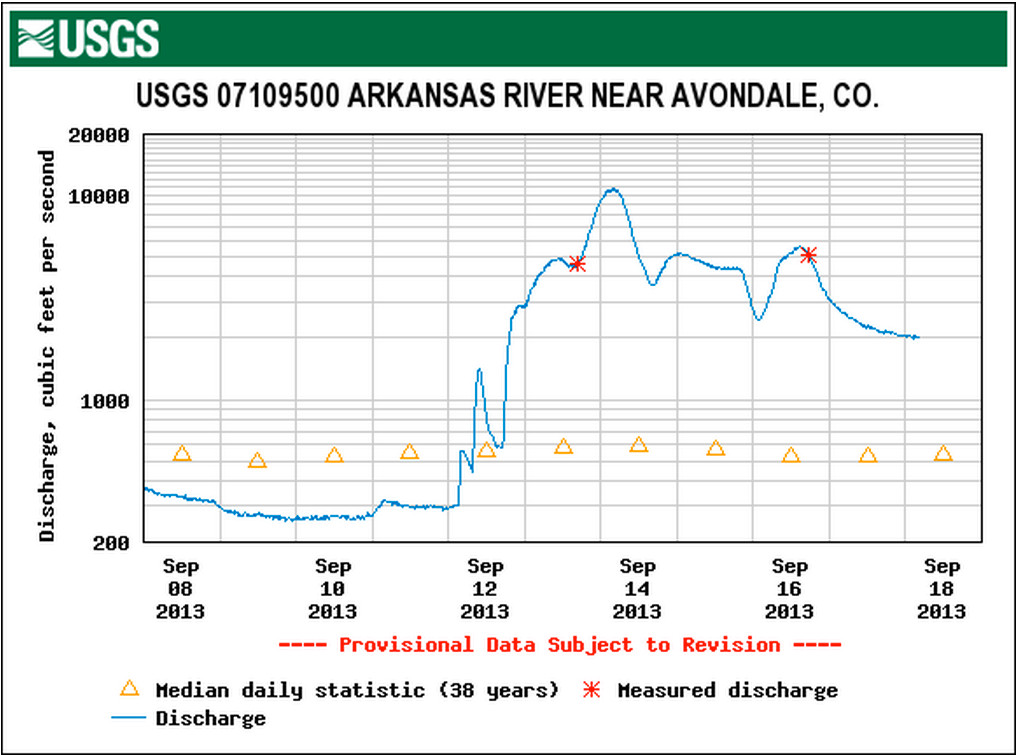
On Friday, Fountain Creek at Pinon passed flood stage for about 12 hours. Later, the Arkansas River at Avondale crested at 9.5 feet, about 2.5 feet above flood stage, and remained high for nearly a full day. It briefly reached flood stage again on Monday afternoon, but quickly dropped. [Click on the thumbnail graphic for the Arkansas River at Avondale hydrograph.]
The worst part is total rainfall for the year — 8.82 inches, officially, remains about 2 inches below average because of the dry winter and spring. “We’ll be watching the snowpack closely this year,” Ward said.
From the Associated Press (Ivan Moreno) via the Laramie Boomerang:
“There is a silver lining if we look down the road,” said Ron Carleton, the deputy commissioner of agriculture for the state. “We just have to get past these near-term impacts.”
The damage to Colorado’s multibillion agriculture industry _ the state’s third-largest at $8.5 billion last year _ is vast: Aerial footage shows broad swaths of inundated farmland. Rows of crops up and down the South Platte River were submerged, everything from corn, lettuce, onions and soybeans.
“We’ve seen these rivers come up before. We’ve never seen it like this,” said Ron Kline Jr., whose family runs Kline Farms in the region.
Carleton, who has been touring the flooded areas, said officials won’t have a full picture of the damage until water recedes. However, they’ve begun to identify potential areas of concern. The corn harvest had just begun, and there could be losses there, as well as in produce farms in Weld County, Carleton said…
Troy Seaworth, whose family owns Seaworth Farms in Wellington, on the northern edge of the flooding, is one of the farmers who will be looking to see how much water was captured in reservoirs. It will take time for that to become evident. “If we capture this year for next year, that’s a good thing _ that’s a great thing,” he said…
Officials are also assessing the extent of damage to irrigation ditches that some crops depend on. With hay and alfalfa underwater, it’s also likely that feed prices will increase because of limited availability. Most of the livestock in the area is safe on higher ground, said Carleton, the deputy agriculture commissioner…
“Large areas of the state will see some agricultural benefits from this storm system,” said Nolan Doesken, Colorado’s climatologist. “Then comes the flood corridors. The flood corridors – wow.”
From CNN.com (Kyung Lah/Faith Karimi):

Runoff from Colorado flooding is coursing into neighboring Nebraska, forecasters said. “The exact crest stages are still uncertain as the waters are just moving into Nebraska,” the National Weather Service said. “It is possible that upcoming forecasts could change so those along the river should stay tuned for updated information.”
From the Omaha World-Herald (Nancy Gaarder):
Floodwaters from Colorado entered Nebraska on Tuesday night, filling in the drought-deprived South Platte River at Big Springs and moving eastward.
Even though communities have had several days to prepare, there has not been enough time to fully protect them from possibly record flooding along a river that rarely floods. Flood protection systems such as levees and reservoirs simply don’t exist on the South Platte. As a result, local officials are focused on protecting critical infrastructure and telling residents to take responsibility for their own property. Farmers are bringing in their harvest early, and homeowners are hauling out possessions or moving them to higher ground.
Up and down the river, emergency dikes and sandbags are being used to shore up wastewater treatment plants, sewer lift stations, telecommunications equipment, water supplies and other systems that make a community livable. “Continuity of government is what we need to make sure happens,” said Dan Guenther, emergency manager in Lincoln County.
Communities along the stretch of the river immediately in the path of flooding are, from west to east: Big Springs, Brule, Ogallala, Roscoe, Paxton, Sutherland, Hershey, North Platte, Maxwell and Brady.
Broken river gauges have prevented officials from getting a good idea of how much floodwater is headed to Nebraska. A much-anticipated Tuesday reading at Julesburg, Colo., fell through because the gauge stopped working. That will change today. A crew from Nebraska’s Department of Natural Resources has gone to Julesburg to assist with taking manual readings there, said Brian Dunnigan, head of the department.
From The Denver Post (Scott Willoughby):
Flooding rivers that broached banks, inundated ponds and blown-out dams have changed the game for anglers along northern portions of the South Platte River drainage. Gushing tributaries such as the St. Vrain, Big Thompson, Little Thompson, Coal Creek and various stems of Boulder Creek are altered beyond recognition. But unlike many of those living along the river banks, the fish will still have a home when the water recedes. The neighborhood — and likely some of the neighbors — will just look a lot different.
“I don’t think we’re anticipating a big fish kill,” said Ken Kehmeier, senior aquatic biologist for Colorado Parks and Wildlife in the region. “It’s a matter of what habitat is left when the rivers drop. There will be some pollution coming down the river, but those fish are pretty resilient, and the amount of water probably diluted it out, so it’s not so toxic to fish. We’ll just have to let the water drop and assess what we have left. After that, we can form a game plan and begin to prioritize our next move.”
Among the immediate concerns for CPW fish managers will be the Bellvue-Watson Fish Hatchery along the Cache la Poudre River and Watson Lake State Wildlife Area. The Watson Lake Rearing Unit, which raises about 300,000 catchable trout every year, was inundated when the lake breached, Kehmeier said, and a water line was damaged.
From The Denver Post (Joey Bunch):
Stories of daring evacuations and selfless courage ripple across Colorado’s waterlogged landscape this week. Hundreds of rescue-team members and firefighters — who train relentlessly to battle blazes, find lost people in the snow and recover fallen bodies from treacherous cliffs — were instead building rope bridges across rushing waters, digging trails in the mud, bracing themselves on uncertain mountainsides and calming rattled evacuees from Colorado’s epic flood.
Darian Shaw saw it firsthand. “The level of their skill and dedication is something to really be recognized,” she said Tuesday. “I can’t say enough.” Before dawn Friday, a world made of mud, rocks, trees and water crashed down on Salina, her Boulder County mountain community of about 80 people. Four Mile Creek, which usually dries up by the end of summer, roared in a pitch of churning water, tumbling boulders and cracking trees. Mudslides rumbled down like thunder, crushing vehicles and homes. Shaw feared the mountain would come plowing through a wall at any moment. “Definitely, it was frightening,” Shaw said. Gold Run Road was washed away, so help for Salina would have to come from above, down the same terrain that was giving way.
Volunteers stepped forward. They carried in ropes, pulleys and a human-sized basket through the deep mud. With four members on each side of the rushing water, they cautiously moved people across in the basket. They worked into the night, at one spot and then another. Members of the Four Mile Canyon Fire Department and the Alpine Rescue Team lifted out her and three other people, two dogs and a canary. Above them, Aspen Mountain Rescue members built stable trails to get people out.
Boulder County Emergency Management said more than 1,500 people were evacuated with assistance between last Wednesday night and Tuesday afternoon. Although most of the evacuees were physically fine, they had gone days without electricity, phone service and information. Also, some were low on food, water and hope.
In Boulder County alone, there were more than 900 rescuers — most of them Army National Guard members and everyday Coloradans who work with volunteer fire departments and search-and-rescue teams.
Many of Colorado’s rescue teams consist of high-country specialists recognized as some of the most skilled in the world. The Alpine Rescue Team, for example, was recruited to help recover pieces of the space shuttle Columbia in 2003, and it has traveled to Israel to train rescuers there.
Each week, its members study in a classroom on weeknights and train in the mountains on weekends. Petrilli said it’s common for members to leave home in the middle of the night for a mission, then go to their jobs the next morning. Members buy their own gear, and they pay the cost when they’re injured, including Band-Aids.
Steve Wilson said the Evergreen-based team averages 110 missions a year, but saving people from their imperiled homes was something unforgettable. “The people we normally see are those who chose to go out in the mountains and got into trouble,” he said. “Sometimes it’s their fault, but not always. These were people trapped in their homes, where they should expect to be safe. “They didn’t do anything to get in their predicament. They lost so much, their homes in some cases, their communities. It’s just different, and it was an honor for us to be there to help any way we could.”
Wilson said he is at his best as a person among passionately caring people. “I get to be around the very best people in the world,” he said. “These are people who spend their own money and risk their lives to help people they don’t know and they’re never going to see again. And they don’t want anything in return.”
Alpine Rescue president Jerry Petrilliand other members of his team stressed they were only part of a large effort. “Colorado has no shortage of good people,” he said.
And when the Rocky Mountain Rescue Group in Boulder asked for help from outsiders, the response was immediate from across the state, said Dixon Hutchinson, the group’s mission coordinator. Petrilli, who had asked for 10 volunteers from his team, heard from at least 30 wanting to go each day. Some of those not picked for the mission waited back at headquarters to clean the rescuers’ gear as late as 1 a.m.
The team’s leader said members’ commitment is something money can’t buy. “We don’t get paid in money; you couldn’t pay me enough to do this,” Petrilli said.”But you look at people who say, ‘Thank you,’ and that’s enough. That’s all I need.”
From the Associated Press via CBSDenver.com:
The official measure of how much water flowed down northern Colorado’s canyons into the South Platte River has been hampered a bit by river gauges that have been swamped by all the water or swept away. Bob Kimbrough, a hydrologist for the U.S. Geological Survey, says crews will have to measure high water marks in those areas to get the official measurements. The agency expects to release its findings on the magnitude of the flooding for a few weeks. Crews attempted to install a replacement gauge in the St. Vrain River near Longmont on Tuesday but the water was still flowing too high.
From the Glenwood Springs Post Independent (Hannah Holm):
The silver lining in this disaster is that it has ended the drought over a good chunk of northeastern Colorado. State Climatologist Nolan Doesken told the Denver Post that “drought as we know it will be ended at a number of locations.” Areas recommended for removal from drought classification include Larimer, Boulder, Gilpin, Jefferson, Lake, western Weld, Northern Park, western Arapahoe, western Adams, Douglas, western Elbert, northern El Paso, central Teller and central Fremont counties.
The flood affected the balance between water supply and demand in two ways: Not only did it bring more supply, but it also decreased demand. Farmers don’t need to, or can’t anyway, irrigate flooded fields. Front Range water managers are banking the extra water in reservoirs, which are filling up at a time when they are normally being drawn down.
Since the Western Slope shares Colorado River water with the Front Range, reduced demands there mean less water diverted across the Continental Divide. As the storms got underway Sept. 12, the Bureau of Reclamation stopped diversions of Western Slope water through the Colorado-Big Thompson Project, which takes water through the Adams Tunnel from Grand Lake to the Eastern Slope.
Although we’ve been spared the floods, the Western Slope has also been pretty wet lately — wet enough that the experts have recommended that the US Drought Monitor reclassify most of the region from “moderate drought” to “abnormally dry” conditions. Between Aug. 18 and Sept. 16, most of western Colorado has received at least 150% of average levels of precipitation for this period.
Going into the fall with nice, moist soils means that more of next year’s snowmelt is likely to run off and help refill reservoirs, instead of being absorbed into the ground. Those reservoirs still need filling. As of Sept. 16, Lake Powell was only 45% full, and Blue Mesa Reservoir, Colorado’s largest, was just 41% full.
From The Denver Post (Jordan Steffen):
For the first time since Colorado’s historic flooding began last week, nature gave residents and rescuers a rain-free day, allowing emergency crews to bring help to stranded people and helicopters to ferry the willing to safety. Thousands of people across a broad swath of the Front Range were still kept out of their homes — or trapped in them — by floodwaters. State officials estimate about 600 people are still stranded in isolated areas. Some of them remained behind even when they were offered escape.
At least 100 people have hunkered down in Pinewood Springs, telling rescuers they will rely on gas-powered generators and trips to Estes Park to resupply as they protect their deluged community from vandals and looters. Frustrated rescue workers showed holdouts pictures of flood-damaged roads to reinforce that this could be their last chance to catch a flight out. “Larimer County doesn’t own any helicopters and won’t be able to do any food and water drops,” Larimer County Sheriff spokesman Nick Christensen said. “If they don’t take this opportunity now, they may be there for a very long time.”
Alaska bush pilot Steve Novakovich, 75, said he was prepared for the aftermath of the rains and flooding that pounded his house in Pinewood Springs, but the days leading up to the dry-out were harrowing. He and his wife, Roma, 70, heeded the emergency flash-flood warnings that went out early Thursday and drove to a high point on their road outside town at 2 a.m. For two hours, they listened as “trees snapped like toothpicks” under the weight of vehicle-sized boulders rolling down the roaring river that had been just a trickle the week before. “I was afraid it was going to take the house,” he said. By Friday, his neighbor’s home had washed into the creek. All utilities were cut. During the several days they were stranded, the Novakoviches kept busy winterizing their house. They had regular visits from volunteer firefighters who kept the community up to date. Each day, they hiked up the hill behind their home to use a cellphone to talk to family and friends for a few minutes. Their pantry was stocked, and their generator fueled, but with the main road to civilization knocked out, Novakovich said the decision to leave was easy — once he figured out what to do with a $700 shipment of salmon and halibut that arrived from Alaska just before the flooding started. Firefighters and rescue workers had a fish cookout Tuesday night — Novakovich’s treat.
That some stayed behind to keep watch made the decision to flee Pinewood Springs a bit easier for others, said a man who would only give his first name, Gary. “Everybody hated to leave their homes,” he said. “But you start thinking about it, and you realize you can’t stick around there.”
The scale of the destruction and losses already tolled had state officials looking to history in search of comparison. In terms of property, the flooding has been the most destructive natural disaster to hit Colorado since at least 1965, when the South Platte jumped its banks and roared through downtown Denver and the Eastern Plains, said Tom Noel, professor of history at the University of Colorado Denver. Recovery will be agonizingly slow.
In Evans on Tuesday, frustration spilled out for a few hundred residents attending a town meeting. About 200 mobile homes and at least 60 houses will be uninhabitable after waters recede, town officials said. “My 2-year-old wants to know when she can go home, and here 90 percent of the people just want to know when they can take a shower,” said Selina Merkt, whose family is living with friends. Their home on the east side of Evans has waist-deep water in the basement and may be condemned. Larimer County alone estimated that flooding has destroyed at least 1,500 homes. Boulder, Weld and other counties were still assessing the damage.
In many areas, the only way to do that was from the air. On Tuesday, the number of National Guard helicopter rescue missions in Boulder County had slowed, and crews shifted their focus to surveying the flooded areas to check on residents who decided to stay in their homes.
Sgt. 1st Class Keith Bart and Staff Sgt. Jose Pantoja leaned out the open sides of a Black Hawk as it flew out of Boulder Municipal Airport and toward the foothills. The crew, based at Fort Carson, has been plucking stranded people from mountain towns for almost a week. As the helicopter moved deeper into the canyons, it passed over ruined roads. In some areas, slabs of pavement piled up against the canyon wall as murky floodwaters continued to wash over them. In other parts, there was no evidence a road ever existed.
The landscape in the foothills west of Boulder was almost unrecognizable. Narrow streets and storefronts that marked the mountain towns — such as Jamestown and Lyons — had been reduced to mudslides and piles of wood and siding. Mud cemented tumbled cars into place. Below, residents shoveled muck and rubble from their driveways. Others hauled boxes and bags out of homes and buildings. Some simply stared at the brown, churning water still rushing through their towns. All looked up, waved and went about their business.
Bart then noticed two red scarves being waved in circles from the deck of a home near Jamestown. The helicopter slowed and hovered low over the home while Bart and Pantoja went into action. They swiftly navigated the complex winch system, clipping into one harness, letting go of another. Within minutes, Pantoja was on his way down. Bart watched and slowly lowered Pantoja until the line went slack. On the ground, Pantoja helped secure two women, each carrying two heavy backpacks, into a harness. As Bart slowly brought the pair up, the weight steadied the helicopter and the winch slowly turned until Bart pulled the women into the cabin. Dazed and exhausted, the women were strapped into their seats. They appeared uninjured. The women waved and smiled at Pantoja when he crawled back into the helicopter and gave thumbs-up as the Black Hawk sped toward Boulder. The thump of the heavy blades drowned the women’s laughter, but their relief was obvious. Within minutes of dropping off the women, the crew returned to the foothills.
Deeper into the canyons, the sunshine revealed the overwhelming devastation. Splintered homes were scattered at the edge of the river that ripped them apart. A shingled roof sprawled out across the bank. Its foundation was nowhere in sight. The walls of one home had been torn away. The dining room was an eerie shadowbox, with the table still in place. Some homes appeared untouched. Colorful flowers bloomed on the doorstep of one home. Across the street, a couch had been washed into the front yard.
In most towns, the roads were filled with drying mud. In Salina, the Little Church in the Pines, which survived the Fourmile fire in 2010, dangled precariously over the edge of a steep bank, where the floodwaters had washed away the earth beneath it.
From the Fort Collins Coloradoan (Sarah Jane Kyle):
During his hourly water check at 3 a.m., [Wesley Sladek] heard a lady screaming.
“I took a really crappy flashlight and walked down our 15-foot hill to the edge of the water,” he said. “Her screams became louder. It was as if she was saying ‘These are my last moments, if you’re going to help me, do it.’ ”
Sladek ran back to his house to grab a rope so he could tie himself to a bush, but by the time he got to the water, the woman was screaming louder. He abandoned the rope and rushed into the river, holding onto bushes and trees to steady himself.
“She was belly up in the water and her leg was sticking out,” Sladek said. “There was so much silt on her face it looked like a horror movie. Every wrinkle in her face was augmented.”
He waded through the silt and water and tried to bring her to the house. The newly formed shore was too unstable, so he moved closer to the river to find solid ground and carried the woman step by step along the water.
“What do I do? We were both sitting ducks,” he said.
His cousins, also stranded in the area, helped Sladek carry the woman, who he only knew as “Florence,” further up the hill. Her leg was broken beyond their ability to repair it. She screamed “as if she had witnessed a bomb going of.” As they tended to Florence, Sladek heard a man screaming for help. Using a flashlight, he and his cousins found a man 15-feet up a tree and stark naked. The river had taken his clothes.
After finding out the man, from Cedar Cove, was in most respects OK and looking at a formidable, deadly river surrounding the tree, Sladek made the tough decision to leave the man until he could better care for Florence.
Floodwaters roil in sand creek east of succor oil refinery north of Denver #coflood #cowx pic.twitter.com/5AkhcUrSHU
— Bruce Finley (@finleybruce) September 12, 2013
Photo of rushing water was taken at the Charles Hansen feeder canal of the Big Thompson feeder canal at 3 p.m. today pic.twitter.com/hLipqrYnsv
— Reclamation (@usbr) September 13, 2013
The National Guard has provided photos/video of affected areas, check it out here: http://t.co/l1Xlzbd7X9 #boulderflood
— BoulderCounty (@bouldercounty) September 16, 2013
Boulder on verge of breaking all-time annual precipitation record http://t.co/Ou49zkHsJs
— ChieftainNews (@ChieftainNews) September 16, 2013
The 7 day precipitation totals for the Denver Metro area from Urban Drainage & Flood Control Dist. #COwx #CoFlood pic.twitter.com/9cE1TTko0q
— NWS Boulder (@NWSBoulder) September 16, 2013
Aerial tour of flood damage to Estes Park, Highway 34 and Big Thompson Canyon: http://t.co/t8VD8pbqyU #COflood
— 7NEWS Denver Channel (@DenverChannel) September 18, 2013
Fountain Creek: ‘People who have never thought about stormwater are thinking about it now’ — Mark Pifher

From The Pueblo Chieftain (Chris Woodka):
After a week of rain, the time seems right. “People who have never thought about stormwater are thinking about it now,” Mark Pifher, Colorado Springs Utilities point man for the Southern Delivery System, told the Pueblo Board of Water Works Tuesday. Rainy days, coupled with mudslides off forest lands that burned in the 2012 Waldo Canyon Fire have made stormwater an in-your-face reality for El Paso County communities in the Fountain Creek watershed.
Meanwhile, there is a lingering concern about whether enough is being done from Pueblo’s point of view. “This is a vital concern to Pueblo and downstream communities,” said Mike Cafasso, chairman of the Pueblo water board.
“This community has been waiting,” added board member Tom Autobee. “It’s kind of come to a head with what we’ve seen in the last few days.”
A ballot issue asking for a stormwater tax or fee is headed for the 2014 ballot, Pifher told the water board. A final recommendation about the specifics of the proposal, form of payment and amount of funding is expected by January. “What happens if it doesn’t pass?” board member Nick Gradisar asked.
“There’s the possibility that some funds can be shifted,” Pifher said.
Colorado Springs has spent or pledged to spend more than $300 million on stormwaterrelated activities since 2000, including $173 million for sewer line fortification after damage from flooding in 1999 and more than $130 million for mitigation related to SDS.
Pifher detailed the progress of an El Paso County stormwater task force that formed last year, explaining that the Waldo Canyon and Black Forest fires have added to a backlog of projects that totals $900 million. He also touched on the internal politics between Colorado Springs Mayor Steve Bach, City Council and El Paso County commissioners. Bach chose not to participate in the task force.
Pifher disputed charges by the Lower Arkansas Valley Water Conservancy District that water quality in Fountain Creek has worsened and flows have increased because of inaction on stormwater. He plans to address those issues with the Lower Ark board today.
Colorado Springs is not required under SDS permits to spend a certain amount on stormwater or have an enterprise in place, although other communities seeking to use SDS are required to have stormwater controls similar to Colorado Springs in place, Pifher said.
He touted the city’s drainage criteria manual as a unifying document that should improve regional storm controls. “We know we need to address stormwater issues in order to make regional alliances,” Pifher said.