A slide presented by Andy Mueller, general manager of the Colorado River District, on Sept. 14, 2018 at the district’s seminar called ‘Risky business on the Colorado River.’ The slide shows how water from the Colorado River system, within the state of Colorado, is used.
Andy Mueller, the general manager of the Colorado River District, presented six principles last week to guide an emerging federal and state program designed to reduce water use in order to avoid a compact call on the Colorado River.
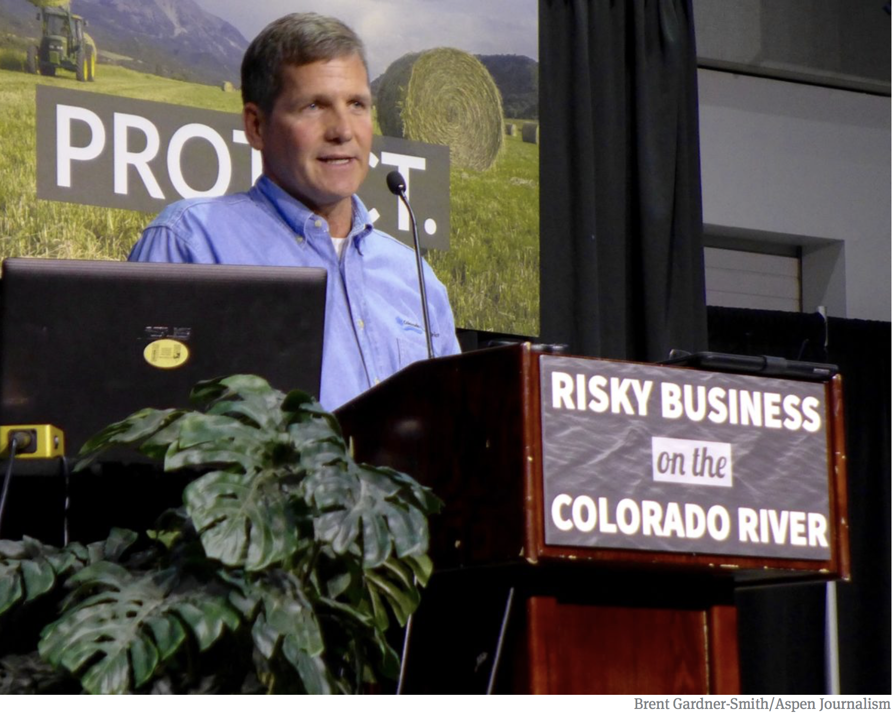
Mueller spoke at a seminar produced by the River District in Grand Junction that attracted 265 people. The theme of the seminar was “Risky Business on the Colorado River.”
The first two principles Mueller described Friday at the meeting relate to a legal bucket-within-a-bucket that the upper-basin states of Colorado, Utah and Wyoming plan to create through federal legislation in Lake Powell, which would allow the three states to control water that they deliver to the big federal reservoir through a demand management, or water-use reduction program.
The River District’s first principle is that such a storage program in Lake Powell should be “free of charge” and designed “for the benefit of the upper basin to avoid a compact violation.”
The district’s second principle says water stored in Lake Powell from a demand-management program should “not be subject to equalization or balancing releases from Lake Powell.”
That principle stems from a set of interim guidelines approved in 2007 by the upper-basin states and the lower-basin states of California, Arizona and Nevada that seek to use water from Lake Powell, when it is at certain levels, to keep Lake Mead operational.
Mueller and other upper-basin regional water managers think the guidelines, which expire in 2026, now allow the lower basin to take more water than they deserve under the 1922 Colorado River Compact.
Mueller told his audience that the demand-management pool to be created in Lake Powell is “for preventing lower-basin entities from sucking too much water down that river.”
So, the second principle is meant to protect the upper basin from the lower basin.
The other principles are designed to either protect the Western Slope from the state, which is discussing potential mandatory cutbacks in water use in order to avoid a compact call, or from the Front Range, which may support such a measure, according to Mueller.
Andy Mueller, the general manager of the Colorado River District, addressing a crowd of 265 water managers, users and stakeholders in Grand Junction on Friday at a River District seminar called ‘Risky business on the Colorado River.’ Mueller spelled out six principles the River District wants the state to embrace as it develops a ‘demand management’ program designed to get the state’s water users to reduce their water use in order to bolster levels in Lake Powell.
Depletions
The River District’s board members are determined to protect agricultural interests on the Western Slope, which use about 1.4 million acre-feet of water from the Colorado River system every year, mainly for irrigating alfalfa fields and pastures.
By comparison, Front Range cities use about 360,000 acre-feet of water a year from the Colorado River Basin through their transmountain diversion systems, which are junior to the 1922 Colorado River Compact.
And if those cities have that water cut off in the face of a call under the compact, Mueller said they would come buy out willing irrigators on the Western Slope and dry up their fields.
The River District’s third principle is that any use-reduction program in the upper-basin states must be “voluntary, temporary and compensated” and “must reflect proportionate contributions from each upper division state.”
Mueller said the River District supports a “guided market” approach to paying water users to use less water and let it flow instead to Lake Powell.
“What we’re opposed to is some form of mandatory uncompensated curtailment of water rights, whether it is pre- or post-compact,” he said.
The fourth principle is that there must be “no injury to other water rights.”
The fifth principle is that there must be “no disproportionate impacts to any single basin or region with Colorado.”
Mueller said Friday that the demand-management program must “make sure that the pain that comes with the reducing consumption of water is actually equitably distributed and applied to all users, everybody with a straw in the river.”
Mueller explained that the post-1922 water rights in the Colorado River basin are roughly split equally between the transbasin diverters on the Front Range and users on the Western Slope.
“These junior water rights that are diverting significant amounts of water to the Front Range, along with our junior water rights on the West Slope, are the ones that need to be willing to share in this demand-management program, in the intentional reduced use,” Mueller said.
The sixth principle is that a demand-management program must be consistent with what’s known as “the conceptual framework” in Colorado’s 2015 water plan relating to future potential transmountain diversions.
“We’re not going to curtail our uses on the West Slope and send demand-management water down to Lake Powell, only to have another transmountain diversion come in and suck water to the East Slope,” Mueller said. “That’s what the state agreed to when it agreed to the state water plan, and we’re saying that needs to be upheld.”
One of the slides in Andy Mueller’s presentation deck on 9.14.18.
Bar fight?
Mueller’s last slide said “the Colorado Water Conservation Board and the state engineer should agree to abide by these principles and not go beyond them without unanimous agreement among those entities charged with protecting the state.”
He plans to deliver that message to the CWCB when it meets Wednesday in Steamboat Springs.
On Tuesday, the River District also released a series of letters and a draft resolution on the issue, including a letter from the River District and the Southwestern Water Conservation District to the CWCB board, a draft resolution from the River District and Southwestern they want the CWCB to approve, a letter from the Colorado Basin Roundtable to the CWCB, and a letter from the Front Range Water Council to the CWCB.
The letter from the Front Range Water Council, an ad hoc collection of the largest water providers on the Front Range, was dated Sept. 13. It includes a reference to the possibility of a non-voluntary water curtailment program in the upper Colorado River basin states of Colorado, Utah and Wyoming.
“If the quantity of conserved water made available through a voluntary compensated demand management program is not sufficient to ensure compliance with the Colorado River Compact,the state of Colorado and the Upper Colorado River Commission may need to adopt alternative measures to generate water for storage in an Upper Division storage account,” the letter states. “We will work with the state of Colorado to develop an alternative mechanism for generating conserved water for the Upper Division storage account.”
In its letter to the CWCB, the Colorado River District and the Southwestern River District, stressed the need for consensus, and their inclusion, on any sort of mandatory curtailment program.
“We are concerned about recent discussions that a demand management program might morph into a mandatory ‘anticipatory curtailment’ program or something else that has not been publicly vetted,” said the letter. “That is the reason we request that the CWCB adopt of (sic) formal resolution or policy-statement regarding a demand management program, and that the CWCB commit that such a program be consistent in particular with Principle 4 of the Conceptual Framework set forth in the Colorado Water Plan.”
Editor’s note: Aspen Journalism is collaborating with The Aspen Times, the Glenwood Springs Post Independent, the Vail Daily and other Swift Communications outlets on the coverage of rivers and water.
Here’s the release from Reclamation (James Bishop):
The Bureau of Reclamation is forecasting a notable increase in releases from Olympus Dam to the Big Thompson River beginning on September 20, 2018.
As of today, September 18, releases from Olympus Dam into the Big Thompson River are at 26 cubic feet per second (cfs). Between September 20th and October 12, releases are expected to rise to approximately 225 cfs.
This forecast assumes native inflows into Lake Estes as well as irrigation demands will not change significantly from our current projections, but both are subject to unexpected fluctuations.
Here’s the release from AWWA Rocky Mountain Section (Dena Egenhoff):
Denver, Colorado (September 18, 2018) – The water has been tasted, the water has been tested and the winner of the “Best of the Rocky Mountain Section” water taste test has been announced! Pueblo Water, Colorado took first place with a panel of veteran judges and media reporters evaluating water appearance, quality, odor, and taste, of course. Competition was stiffer this year with 11 municipalities, from Wyoming, Colorado and New Mexico, competing for the title of the best drinking water in the mountain west during the 2018 annual conference of the Rocky Mountain Section of the American Water Works (RMSAWWA) in Denver, Colorado. You can learn more about the winner Pueblo Water utility by visiting http://www.pueblowater.org. Second place was awarded to City of Santa Fe Water Division, New Mexico, with Roxborough Water and Sanitation District-Littleton, Colorado coming in third.
Pueblo Water will now go on to represent the mountain west in the national “Best of the Best” water taste test at the American Water Work’s Annual Conference and Exposition (ACE 19) in Denver, Colorado June 9-12, 2019. Over 12,000 water professionals across the country will gather at ACE 19 where best-tasting tap water in North America will be declared.
Judges this year’s event were the voice of the Colorado River basin and water issues in Western U.S. Luke Runyon with KUNC Harvest Media, Jamie Sudler the voice of H2O radio and KGNU that inspire people to connect to water issues, veteran sensory taste tester Jordan Kelly with Odell Brewing, Mark Jockers the Government and Public Affairs Manager for Clean Water Services and brewer of beer from treated wastewater, Pinar Omur-Ozbek an assistant professor of engineering and renowned water expert with Colorado State University, and Alan Forrest, American Water Works Association Vice-President.
The RMSAWWA is the regional section for the AWWA, which is the largest non-profit, science-based organization for drinking water professionals in the world. The RMSAWWA covers Wyoming, Colorado and New Mexico and has over 2,400 members, representing water utilities, engineering consultants and water treatment specialty firms.
With high marks for its mineral-rich, clean flavor, Greeley took fifth place Monday in the American Water Works Association’s Rocky Mountain Section awards.
The city, which came into the competition to defend a national title, faced stiff competition this year from three states: Colorado, New Mexico and Wyoming. Pueblo Water ultimately won the competition, according to a news release, beating 11 other municipalities. The competition was hosted during the 2018 annual conference of the Rocky Mountain Section of the American Water Works in Denver.
In 2017, Greeley won the award and went on beat out 33 regional winners to earn the distinction of having the best-tasting water in the nation at the American Water Works Association’s annual conference. It also won the People’s Choice Award, making it the first city ever to win both.
In an email, Aaron Benko of Denver Water said Greeley shouldn’t take down billboards that highlight the city’s water quite yet.
“I believe that Greeley is still the only utility to win the Best of the Best and People’s Choice,” he said.
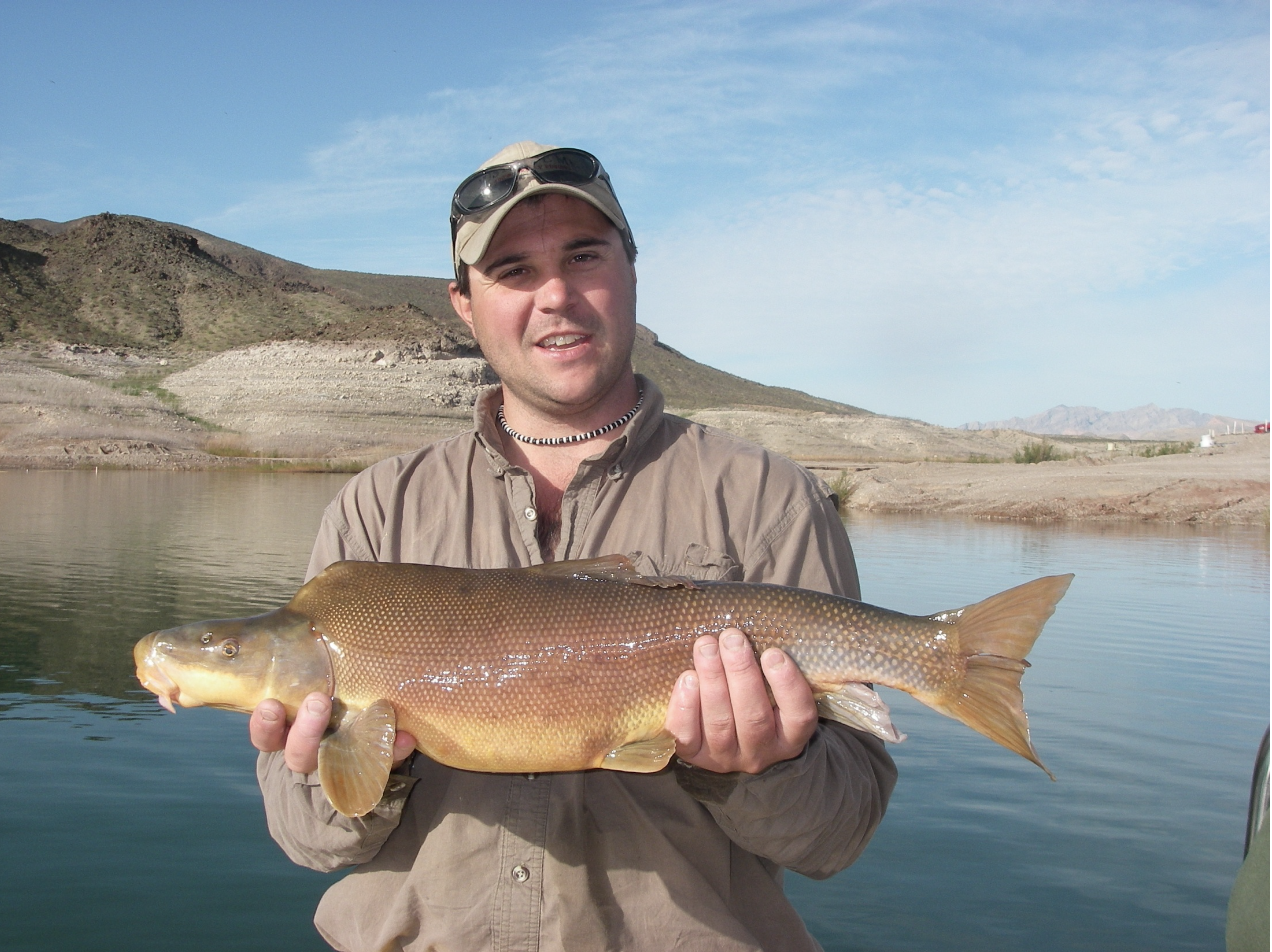
Ron Rogers biologist with Bio-West Inc., holds a large razorback sucker captured in Lake Mead near the Colorado River inflow area
Here’s the release from the Bureau of Reclamation (Mark McKinstry, Amee Andreason):
The Bureau of Reclamation today awarded a $3.4 million contract to Bio-West Inc., of Logan, Utah, to determine how habitat, flows, water temperatures, trends in other fish species and other variables affect the endangered razorback sucker in the Lake Mead and the Grand Canyon inflow areas.
The razorback sucker is one of four large-bodied river fish native to the Colorado River Basin. Currently listed as endangered under the authority of the Endangered Species Act, the fish was historically abundant throughout the basin and was predominately found in the main stem river and major tributaries of Arizona, California, Nevada, New Mexico, Utah and Wyoming. The current distribution and abundance of razorback sucker is greatly reduced from historic levels. However, populations have persisted, made possible due to aggressive stocking efforts throughout the Colorado Basin.
Grand Canyon and Lake Mead currently have the only self-sustaining and recruiting population of endangered razorback suckers in the Colorado River Basin. Under this contract, researchers will be able to study this population of fish to determine their population numbers, age structure, movement patterns from the river back and forth to Lake Mead, and spawning areas in the lake and river. Understanding this population will help in the recovery of this critically endangered fish throughout its range.
The work accomplished under this contract will include seven 2-week efforts in Grand Canyon from March through September 2019 and will investigate adult razorback sucker spawning and movement patterns in Grand Canyon and Lake Mead. This will help to identify the types of habitat used by these fish in addition to determining a population estimate. These activities will support conservation efforts in the Grand Canyon and Lake Mead and will provide updated information on a U.S. Fish and Wildlife Service proposal to revise the recovery goals for the razorback sucker.
FromThe High Country News (Jonathan Thompson). This article first appeared in The High Country New on Sept. 21, 2017:
Coal. Guns. Freedom.
I saw these three words on a little sticker affixed, discordantly, to the window of a car in a small Colorado town. It struck me as funny at first: Coal and guns being elevated to the status of platonic ideals or, even more loftily, the refrain of a bad country song. All it was missing was Jesus, beer and Wrangler butts. A few days later, though, as I sat on a desert promontory overlooking northwestern New Mexico, the sticker didn’t seem so funny. As the sunrise spilled across sagebrush plains and irrigated cornfields, it also illuminated a narrow band of yellow-brown clouds on the horizon.
The clouds were smog, a soup of sulfur dioxide, particulates, nitrogen oxide and other pollutants emanating from the smokestacks of the coal-burning Four Corners Power Plant and San Juan Generating Station, on either side of the San Juan River Valley. The people of the Four Corners have experienced that cloud in one form or another nearly every day for the past half century. Our skies have been sullied, as have our lungs; mercury wafts from these and other smokestacks and falls with rain on Mesa Verde National Park and in the clear, icy streams of the San Juan Mountains. The plants suck millions of gallons of water from the river each day for steam production and cooling, and they leave behind mountains of ash, clinkers and sludge, tainted with mercury, arsenic, selenium and other toxic material. That’s all in addition to the tens of millions of tons of climate-altering carbon dioxide the stacks release each year.
We’ve been told that this is just the price we pay for power, that this is what it costs to keep the lights on in Phoenix, Las Vegas, Los Angeles, that we have no choice but to live with it. To stop burning coal, or even try to mitigate the harm, we’ve been told, will put thousands of hard-working Americans out of a job, skyrocket electricity costs, and black-out our lights and computers.
Coal. Guns. Freedom.
Now, however, as many of the biggest coal plants near the end of their lives, coal-fired electricity is going the way of the steam locomotive and manual typewriter. It’s becoming clear that King Coal was a big lie, a long-standing myth. For decades, we’ve been hoodwinked by the fetishization of coal, to the detriment of us all.
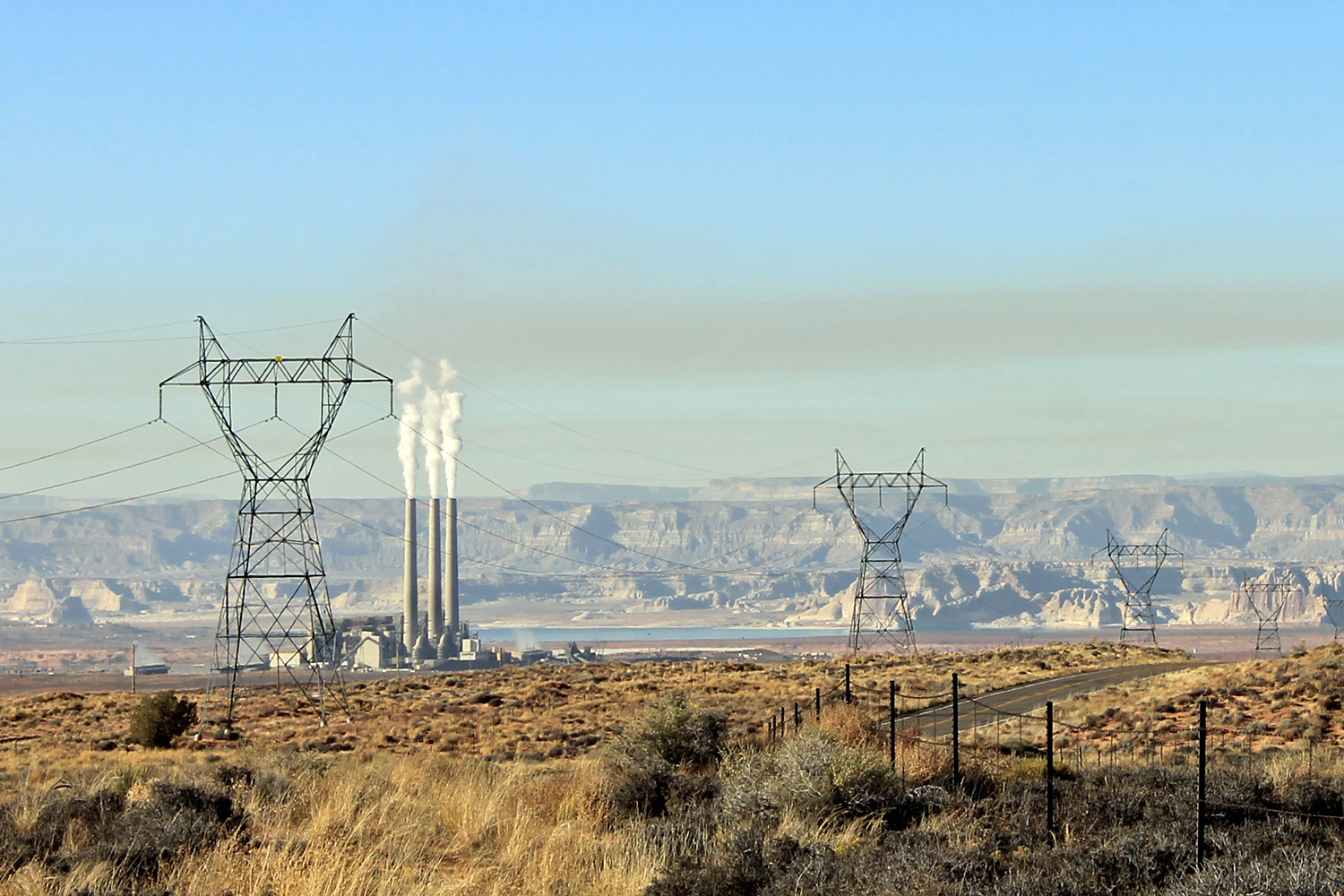
Navajo Generating Station and the cloud of smog with which it blankets the region. Photo credit: Jonathan Thompson via The High Country News
Coal fueled the white invasion of the West. It stoked smelters, powered locomotives and generated steam, driving mills that processed tons and tons of rock. Newcomers heated their homes and cooked with coal, thousands of them toiling in mines to keep the fires going. The coal industry rose up on those miners’ backs, reaping enormous profits that lined politicians’ pockets. These lawmakers returned the favor by keeping regulations minimal and royalties low on federal mineral reserves, and by sending in troops to murder striking miners. “Coal is the fuel of the present,” crowed the author of a 1906 US Geological Survey report, “and so far as can be seen, will continue to lead … for a long time to come.”
Yet even then, Westerners were slowly shifting away from the expensive, dirty and inconvenient fuel. The electricity that powered the mines and towns was, by and large, generated from falling water. And when the pipelined bounty of the 1920s’ natural gas boom spread from New Mexico and Texas across the West, homeowners switched en masse to gas for cooking and heating, saying goodbye to stokers, clinkers and coal’s pervasive, greasy film.
By 1950, coal provided a mere 10 percent of the West’s electricity. Natural gas generation was eating into that slice, and plans for a network of dams along the Colorado River threatened to flood the grid with even more cheap, coal-displacing hydropower. Steam locomotives went the way of the dinosaurs, driven to extinction by diesel. American coal consumption fell by 20 percent in the 1950s alone; in the West it plummeted by 40 percent.
Facing an existential crisis, the coal industry executives knew they could not compete based on the merits of their fuel. Instead, they set out to imbue it with symbolism and mythology. Coal was not just coal, the lobbyists argued. It was abundant, reliable and deserving of a seat in the pantheon of American culture, alongside cowboys, guns — and, yes, freedom. (They also managed to convince the Sierra Club that coal plants were a green alternative to river-ruining dams.)
Most of all, coal was equated with honest jobs for hard-working miners (and voters) — never mind that mechanization and efficiency had been killing off mining jobs since the early 1900s. The shift from coal to diesel and natural gas was framed not as mere consumer choice between commodities, but as an attack on some ineffable American value.
Coal. Guns. Freedom.
The industry enlisted Sen. Wayne Aspinall, a Democrat from the coal state of Colorado, to its cause, and Congress created the Office of Coal Research in 1960 “to encourage and stimulate the production of coal in the United States through research and development … and maximize the contribution of coal to the overall energy market.” Lawmakers from coal-producing counties and states ganged up on other forms of energy, taxing natural gas, for example, or requiring public institutions to heat with coal, free market be damned.
In 1952, the U.S. Bureau of Reclamation released its “Study of Future Power Transmission for the West.” It revealed the perverse logic that prevailed at the time: Since both the population and per capita electricity use were rapidly increasing, new power plants were needed. The new power supplies would lower electricity prices, thus drawing more people and encouraging more consumption, which would then spur the building of more power plants, and so on. It was a recipe for a slow-building disaster, regardless of what fueled the power plants. Pushing coal as the main ingredient made it that much more catastrophic.
The authors of the report acknowledged that natural gas was relatively cheap and clean, easy to transport and abundant. Nevertheless, they recommended coal to power the massive fleet of new plants, because they worried that natural gas supplies might someday run short. In so doing, they signaled that the federal government, far from being “fuel neutral,” had a strong preference for coal. The mythology around coal became policy.
Starting in the mid-1960s, coal plants were built across the nation at a rapid rate, with more than 10,000 megawatts of coal-generated capacity — the equivalent of about five Four Corners power plants — added annually. Smoke-belching plants rose up from the deserts of Utah, Arizona and New Mexico, including several on or near the Navajo Nation, sending their juice to the air conditioners, televisions and “electrified homes” of Los Angeles, Phoenix and Las Vegas. Monstrous draglines gouged into spare mesas, and smog settled over valleys and obscured mesa and mountain views. Each of the new plants emitted at least 10 million tons of greenhouse gases annually.
The coal frenzy was not dampened by the passage of the Clean Air Act of 1970 — it took years to implement the law, and even longer to enforce it. In 1977, Congress strengthened the act in ways that would give cleaner-burning natural gas a leg up. But that was nullified by another law, the Powerplant and Industrial Fuel Use Act of 1978, which prohibited the use of natural gas as a primary fuel for generating electricity. It was a blatant act of market interference, in which the government chose coal over cleaner-burning natural gas. Lawmakers and lobbyists argued the law would help the U.S. achieve energy independence, but that was yet another myth. All it really did was double down on coal, thus tightening a stranglehold on the nation’s grid that would take decades to loosen.
This April, in a move that harkens back to the 1950s, Energy Secretary Rick Perry launched a review of the electrical grid, clearly looking to kill regulations and otherwise prop up the flagging coal industry. Perry presumed that reliable and “critical baseload resources,” such as coal-power, were being unfairly bullied off the grid by “regulatory burdens” and “the market-distorting effects of federal subsidies that boost one form of energy at the expense of others.” Meanwhile, long before the review was complete, the Trump administration went about killing environmental protections aimed at keeping harmful pollutants out of the air, rescinded an initiative to get corporations to pay their fair share for mining coal owned by U.S. taxpayers, and halted a study of the effects of mountaintop mining — all in the name of reliability, affordability and, of course, jobs.
It must have been a shock, therefore, when Perry’s own experts concluded in August that government interference isn’t killing coal; the free market is. “The biggest contributor to coal and nuclear plant retirements has been the advantaged economics of natural gas-fired generation,” the study’s authors wrote, essentially repeating common knowledge. Furthermore, coal’s phase-out and the increase in renewable energy on the grid have not hurt reliability or, for that matter, caused a net loss in jobs.
The findings were of little surprise to industry watchers. Coal’s foreseeable decline began when Congress repealed the Fuel Use Act in 1987. That opened the way for a huge buildup of natural gas-generated capacity. When the shale drilling revolution glutted the market with natural gas beginning in 2008, an abundance of power plants were already on hand to put it to use. The Great Recession caused electricity demand to plateau at about the same time, and the combination of factors caused wholesale electricity prices to fall. The myth of coal as the most affordable fuel perished, though its greater symbolism has proven more stubborn.
The buildup of wind and solar power further decreased overall electricity prices in relation to coal. Playing a minor role in coal’s misfortune were “a suite of environmental regulations” — from the Clean Power Plan to the Mercury and Air Toxics Standard — that, Perry’s review says, “had varying degrees of effects on the cost of generation.” While these rules do affect coal more than other fuels, they aren’t “unfairly” targeting coal, as the industry and its boosters contend. Rather, they target air pollution, and coal happens to be the most polluting fuel currently in use. Other Obama-era regulations are harder on natural gas — both the Environmental Protection Agency and Bureau of Land Management’s methane rules targeted oil and gas production, leaving methane-venting coal mines alone.
Between 2002 and 2016, some 59,000 megawatts of coal-generated capacity were taken off the grid nationwide due to plant retirements. Salt River Project announced it would shut down its Navajo Generating Station in 2019 because the plant no longer made economic sense. Colstrip in Montana is slated to go dark in 2027, and Intermountain Power Project in Utah will close in 2025. Public Service Company of New Mexico wants to phase coal out altogether over the next 15 years, which includes shutting down San Juan Generating Station in 2022 and divesting from Four Corners Power Plant. It won’t be an easy task, since the utility currently gets 54 percent of its electricity from coal, but PNM analysts insist that more efficiency and a switch to natural gas, nuclear and renewables will cost their ratepayers less in the long-run.
Energy Information Administration
Even the coal plants that continue to run are seeing less use, and different uses, causing coal to lose ground. The Navajo Generating Station put out 30 percent less power in 2015 than it did two years earlier, for example, so if it weren’t scheduled to be shut down, it might just fade away. Two decades ago, coal plants were mainly used as a baseload power source, meaning they’d run at maximum output around the clock in order to supply the minimum demand on the grid. Yet in 2016, according to a Western Interstate Energy Board analysis, only a small handful of plants spent more than half the year in baseload operation.
So when coal plants go dark, the grid won’t lose much in the way of baseload power or the reliability it purportedly provides. “Reliability is adequate today,” Perry’s review concludes, going on to say that the loss of capacity due to retirements has been replaced, and that energy-source diversity is as high as ever. Another piece of the coal myth, smashed.
One of the few things that coal-generation has going for it is “fuel assurance.” That is, coal plants can stockpile fuel on site. Natural gas is more difficult to store, and relies on vulnerable pipeline networks. Solar and wind power are weather dependent. For the centralized coal plants of the Interior West, however, fuel assurance is offset by the fact that the plants rely on long-distance powerlines to deliver the goods, and those not only leak a lot of electricity, they can be taken out by extreme weather, wildfire, saboteurs and even squirrels.
Such practical considerations, however, do not make for powerful myth. Symbolism does. And the coal industry seethes with symbolism.
Coal. Guns. Freedom.
Perry’s grid review found that the coal industry has shed nearly 40,000 jobs over the last 15 years, but attributes those losses not only to the downturn in demand but also “increased mechanization and a shift to western coal” — the massive mines of Wyoming’s Powder River Basin need fewer workers than those in Appalachia to extract each ton of coal. For each job lost due to displacement of coal by natural gas, solar or wind power, another rose to take its place in an electricity generation-related industry. The Energy Department’s 2017 employment report found that coal power plants and mines employed about 160,000 people, while the wind and solar industry provided more than 475,000 jobs. Coal jobs carry far more symbolic and therefore political heft, however, since no one has yet figured out how to romanticize solar-panel installation.
When Obama was castigated for a so-called war on coal, it was not for trying to mitigate a catastrophic global habit, but for attacking miners, a powerful symbol in rural, white, American culture (85 percent of coal miners are white men, according to the Bureau of Labor Statistics). When Trump demonstrates that he “digs coal” by rolling back regulations, he’s banking on rural nostalgia and pushing back against Obama, who for portions of white America became a symbol of urban elitism, progressivism and blackness.
Coal boosters have meanwhile seized upon this mythology for cynical ends. Trump has used it to blot out Obama’s legacy (one of his few discernible policy goals), and to solidify his base of white, male voters. The regulation rollback is good for coal’s bottom line, yet instead of using the savings to hire more workers, companies have poured the extra revenue into executive pay and bonuses. Top executives in the industry make, on average, $200,000 per year, plus millions of dollars in bonuses, while a miner toiling in dangerous conditions gets just $55,000 — if he hasn’t been replaced by a machine. The pay gap has only grown as the industry has faded, as though the folks at the top are grabbing all they can before the industry crumbles.
Meanwhile, neither Trump nor anyone else is helping out the miners themselves, the humans behind the symbolism. The Trump administration has delayed or rolled back a number of rules aimed at miner health and safety and nominated a former coal executive to head up the Mine Safety and Health Administration. Mining-related fatalities are up this year, with 20 deaths overall, 12 of which were in coal mines. And the Republicans in Congress are working hard to lower taxes on the rich — which doesn’t include most coal miners — at the expense of the rest of us, and to dismantle the Affordable Care Act, which although flawed and fragile, remains the best safety net many have.
If anything, the Energy Department’s review of the grid made it clear that rescinding regulations would do nothing to save the coal industry, or the miners who make it run. It offered very few justifications for saving coal plants. But that’s unlikely to stop Trump, Perry and friends from doing what they can to prop up the coal industry. After all, they’ve got the myth behind them. As for the land, the air, the water, and the people who live near and work in the plants and mines, they’ll continue to pay the price for coal, guns, and freedom. And if those ever become the lyrics of a country song, it will be a tragic one indeed.
Jonathan Thompson is a contributing editor at High Country News. He is the author of a book about the Gold King Mine spill. [ed. It is interesting how the fossil fuel industry is using many of the same arguments in 2018 that were used by the extractive industries that Thompson chronicles. I guess they work.] Follow @jonnypeace
On Aug. 25, Republican Sen. John McCain died of brain cancer after representing Arizona in Congress for more than three decades. Responsibility for appointing McCain’s replacement fell to Arizona’s Republican Gov. Doug Ducey, who faced a difficult choice: Should he appoint an establishment Republican in the mold of McCain, or a far-right flamethrower like President Donald Trump? Last Tuesday, Ducey made his move, installing former Arizona Sen. Jon Kyl, R, who retired in 2013, in McCain’s seat.
Ducey’s decision is a stabilizing and pragmatic one, and in an especially turbulent political moment, it seems to transcend pure political expediency. Kyl, who has a history of negotiating important and contentious water deals, returns to the Senate at a critical juncture for Arizona’s future water security, as it struggles to finalize its portion of the so-called “drought contingency plan” for the lower Colorado River.
The two other states in the Lower Colorado River Basin — Nevada and California — have already hammered out how they’ll contribute to the plan, a voluntary water conservation agreement aimed at boosting water levels in Lake Mead. The states hope that by taking less water from Lake Mead now, they can prevent more severe shortages that will be imposed if the shrinking reservoir drops below certain levels. Arizona’s failure to adopt a plan — the result of a self-defeating battle between two water agencies over how much the state should voluntarily conserve — is holding up this critical planning process. And ironically, Arizona has the most to lose from failing to stave off shortages. Because it holds the most junior water rights to the Colorado River, the amount of water it siphons from the river to keep Phoenix, Tucson and hundreds of farms wet would be cut the most during a shortage, which could be declared as soon as 2020.
Kyl’s expertise could be crucial in the final negotiations over the three-state plan, and impacted Ducey’s decision to send him back to the Senate. Kyl, a former water attorney, ushered landmark water-rights settlements through Congress during his previous tenure, resolving decades-long legal disputes between the federal government and Arizona tribes. “His expertise on water and natural resource issues will be very beneficial to our state as we face new challenges in those areas,” Ducey said in his August announcement. “Now is not the time for on-the-job training.”
In Arizona, water has historically been an area of bi-partisan collaboration, but that has shifted in recent years, according to Chuck Coughlin, a longtime Arizona GOP consultant who worked on McCain’s first Senate campaign in 1986. The current drought planning has mostly been stymied by disputes between agencies within Arizona, but Republicans are also caught between conflicts among their constituents — namely, agricultural interests and developers — as water becomes more of a political concern among voters.
And growing partisanship on both the far-left and far-right has made consensus on water issues more difficult to reach. “There’s distrust from both parties that collide over water in Arizona,” Coughlin said. “The right distrusts any deal involving the federal government, and the left holds a lot of distrust about the state being able to confront scarcity over climate change. Kyl certainly has demonstrated the ability to bridge those sentiments in the past.”
Kyl will not play a major role in the drought plan’s details. But the agreement will have to pass the state Legislature, and because it’s part of a multi-state effort, it will require federal legislation to become legally binding. Kyl — if he continues to hold the Senate seat — would be expected to exert pressure on state lawmakers and Congress to finalize a deal. And Ducey hopes that Kyl will play “an active role” at the federal level in more broadly representing Arizona’s interests in the West’s ever-shrinking water supply. Of course, Kyl has only committed to serve through the current session, and it’s possible the drought plan won’t make it to Congress by then.
Ducey’s decision to bring Kyl back also included more partisan calculations. Kyl was sworn in the same day confirmation hearings began for conservative judge Brett Kavanaugh, a nominee for the U.S. Supreme Court. As a lobbyist at Covington & Burling, Kyl has helped shepherd Kavanaugh through the confirmation process, and is sure to vote to put him on the high court, cementing a conservative majority for perhaps decades to come.
Kyl’s selection also illuminates the delicate politics of a changing electorate. As a whole, historically deep-red Arizona is becoming more moderate, and Democrats have a realistic shot this fall of flipping retiring Republican Sen. Jeff Flake’s seat. Yet the Republican base in Arizona remains as conservative as ever. In the GOP primary for Flake’s seat, the anti-immigrant former sheriff, Joe Arpaio — who forced prisoners to wear pink underwear and march in chain gangs — got 20 percent of the vote. Kelli Ward, who campaigned with far-right conspiracy theorist Mike Cernovich and hinted that McCain timed his death to hurt her Senate bid, got 28 percent. Martha McSally, who entered the campaign as a measured McCain-style Republican, then tacked right, won with 53 percent.
In choosing ultra-conservative Kyl, Ducey, who is also up for election this November, won’t anger his base and is also unlikely to alienate moderate voters because of Kyl’s reputation for getting things done. The GOP establishment hopes that Kyl’s presence in the Senate, even if it’s brief, will bridge some of the partisanship with his “get real” presence. “(Kyl’s) governing capabilities shouldn’t be overlooked,” said Paul Carrese, a political research and director of Arizona State University’s School of Civic and Economic Thought and Leadership. The Senate is far more partisan than it was even six years ago. “But Kyl has demonstrated that he knows the place and has experience.”
Paige Blankenbuehler is an assistant editor for High Country News.
Parties in Arizona must keep pushing to leave more water in Lake Mead.
The new Lake Mead forecast is out… and it isn’t pretty. The Bureau of Reclamation (USBR) now predicts a 57% likelihood that Lake Mead will drop below 1,075 feet in 2020. The risk has grown an additional 5% since the last update.
This means there is nearly a 3 in 5 chance there will be mandatory reductions in Colorado River water for farmers in Central Arizona, and less water for the Central Arizona Groundwater Replenishment District (CAGRD), which uses “excess” water, when available, to offset groundwater pumping for specific housing developments. Stated a different way, this could affect Arizona’s economy. Elsewhere in the Lower Colorado River Basin, specifically in Mexico, other water users will have less water to use as well. But because of deals and compromises that Arizona negotiated in the past, water users in California and Nevada won’t feel the impact of the shortages to the same degree.
As the Steering Committee charged with securing Arizona’s commitment a new statewide deal to reduce Colorado River water use slogs on despite imminent shortage, Arizona faces incredible risk. Under current rules Arizona is exposed to bearing the brunt of Colorado River shortages, which could be catastrophic. In the event of extended drought, central Arizona could lose its entire Colorado River water supply in the next 5 years.
The solution on the table, the Lower Basin Drought Contingency Plan (DCP), would engage California and Nevada to share the pain of reducing water use along with Arizona, and would trigger an agreement already in place with Mexico to conserve even more. (It’s important to remember that the U.S. – Mexico agreement adopted in 2017 that commits Mexico to more water conservation also commits the two countries to habitat restoration in the Colorado River Delta.) Moreover, under the DCP’s rules water users would conserve water more frequently, but in smaller volumes. The DCP is effectively an insurance policy that engages many to make relatively small cuts in water use so it’s less likely anyone (read: Arizona) is hit with catastrophic cuts.
We understand these can sound like fighting words to water users asked to sign on to a new deal for something that may not appear, on the surface, to bring immediate relief from water shortages. Indeed, the DCP cannot create new water. But it does establish a broader base to share in reducing water use. And by starting water conservation requirements earlier than is currently required, it reduces the probability of Lake Mead sinking so low that no water can be released at all. If Arizona stakeholders can rally themselves to agreement, the DCP will buy the state some time and engage Mexico, California, and Nevada in their commitments to leave more water in Lake Mead. We need them.
It is up to Arizona’s Colorado River water stakeholders—tribes, cities, farmers, homebuilders, businesses, non-governmental organizations, and residents—to keep pushing each other towards consensus on the deals within Arizona that make using less Colorado River palatable (we didn’t say enjoyable) to water users.
That means:
Reasonable mitigation for Central Arizona Project agriculture in return for their commitment to use less Colorado River water
Permission for Arizona’s tribes to leave more water in Lake Mead on a voluntary basis
Recognition of the limits of Colorado River water supplies to support future growth in Central Arizona
Coordination among parties to sustainably manage Arizona’s Colorado River supplies
Maintaining Arizona’s legacy of groundwater management statewide, ensuring the reliability of regulations already in place
The problem is clear, and one significant step toward a solution, the DCP, is teed up for Arizona to embrace. People, birds, and Arizona’s sustainability depend on it.
Central’s Board places GMS bond measure on November 2018 ballot
The Board of Directors of the Central Colorado Water Conservancy District placed a bond question for the Groundwater Management Subdistrict on to the 2018 ballot. Central’s board and management stated this measure is important to start planning the next steps to secure water rights and build storage for the region. The projects in the bond include:
Construction of 5,000 acre-feet of additional reservoir storage—which will increase Central’s holdings by 25 percent—in the Fort Lupton and Greeley/Kersey areas.
Construction of the Robert W. Walker Recharge Project, a large project at the Weld and Morgan county lines that will divert water from the South Platte River and send those flows to groundwater recharge basins as far as 5 miles from the river. This will increase drought resiliency for water users in the District. Central was awarded $1.5 million in state and federal grants for the estimated $15 million project.
Purchase of several senior water rights that are becoming available for the District’s portfolio, including the purchase of water currently being leased by Central, which will ensure this water stays in the community to be used by local farms and businesses.
To review the ballot language, click here. Please contact Central’s office if you have any questions.
Randy Ray said every local water manager remembers years like 2002 and 2012.
“That’s one thing water managers don’t forget: the dry years. We always forget about the wet ones, except for the catastrophic floods,” said Ray, executive director of the Central Colorado Water Conservancy District. “How did their water supplies react to the dry years?”
Water officials try to answer when they look toward the future of their systems. That’s why the Central Colorado Water Conservancy District will place a $48.7 million bond question on the ballot this November in an effort to address priorities that, officials said, would help the district plan for droughts such as the ones that ravaged this part of the state in 2002 and 2012. Another drought currently bakes portions of the state this year, as well.
Central’s boundaries stretch through parts of Weld, Adams and Morgan counties and serve about 550 farmers who operate about 1,000 irrigation wells…
The recharge project, the biggest of the three, would claim an estimated $15 million of the funding in an effort to divert water from the South Platte River and send flows to groundwater basins about 5 miles away from the river. Officials said that would create storage to increase drought resiliency for the district’s water users.
For Ray, the recharge project is a solution to problems years in the making.
“It’s complicated, but then again, it’s simple,” he said. “If you want to pump groundwater, you’ve got to replace it. We’re just simply putting water in the aquifer to offset pumping and generate additional supplies that we can count on.”
Recharge projects, which have been in use for decades, exploded in the late 1990s, as strict regulations for well pumping required water users to replace the groundwater they pumped. They work by diverting water to a pond and allowing it to seep into the ground, and eventually, back to the river.
At the Walker Recharge Project, which is named after a former district president, officials plan to divert the water from the South Platte River when it’s flowing at a high level to ponds along a plateau as far as 5 miles away.
The district purchased the land for the project in 2015 after it became clear to Central officials that the district can’t rely on leasing reusable water from Thornton, Aurora, Longmont and Westminster sewer discharge plants the way it has in the past.
Because the population in those cities is growing, Ray said, city officials are more reluctant to give their extra water supplies away. Water managers in those cities remember dry years such as 2002 too.
Plus, Ray said, the district views the projects as better financial investments.
“It’s like renting a house,” Ray said. “The landowner is getting the equity, and you’re just basically paying their mortgage.”
Ray said the other main projects outlined in the ballot question — the reservoir storage and additional senior water rights — also will play a role in helping the district rely less on water leases from cities. The gravel pit reservoir storage, he said, would help the district divert water from the river quickly when water levels are high for additional storage.
But Ray said the biggest selling point for the bond issue is agriculture.
“That’s our big campaign, our big message to our constituents, preserving irrigated agriculture in the county,” Ray said.
By purchasing additional senior water rights, he said, the district could help slow a trend called “buy-and-dry,” in which cities buy water rights from farms.
“So, when one of those cities purchases those water rights, they retire the land, and it’s got to go back to a dry land setting, which has a lot of negative associations with that,” Ray said. “The economy dries up and the tax bases go away.”
If Central takes over that water right, Ray argued, farmers would still have access to groundwater to irrigate a portion of the farmland.
“If you’re 80 years old, 70 years old, that farm and its water rights are your 401(k),” Ray said. “We want to be an alternative to these beautiful senior water rights in Weld County being transferred to Denver, Arapahoe, Douglas counties and reside here under the management of the water conservancy district.”
Here’s the release from Colorado Springs Utilities:
Board extends offer for CEO
In an open session on Sept. 17, the Utilities Board unanimously voted to extend an offer to Aram Benyamin to be the next Chief Executive Officer (CEO) of Colorado Springs Utilities.
Nearly 130 candidates from across the United States submitted their resumes for consideration. In June, the Utilities Board reviewed the top candidates and determined which candidates should complete advanced screening. In July, the Board reviewed the information and selected seven candidates to proceed as semifinalists.
Over the last few weeks, the full Utilities Board conducted seven semi-finalist interviews with internal and external candidates. Deliberations on who would be moving on as finalists were concluded prior to the Aug. 22 Board meeting.
As part of the process, there were opportunities for employees and the public to meet the CEO finalists and provide feedback to the Board. The Utilities Board incorporated the feedback they received from employees and the public and considered the information as they interviewed the candidates.
Aram Benyamin, P.E.
General Manager of Energy Supply
Colorado Springs Utilities
Aram Benyamin currently serves as the General Manager of the Energy Supply Department at Colorado Springs Utilities.
Prior to Colorado Springs Utilities, Mr. Benyamin was the Senior Assistant General Manager, head of the Los Angeles Department of Water and Power’s (LADWP) power system, the nation’s largest municipal utility.
At LADWP, Mr. Benyamin was responsible for 4,000 employees with an annual budget of $3.9 billion, serving more than four million residents of Los Angeles.
LADWP’s power system spans over four states. It includes 7,327 megawatts of generation capacity, 3,507 miles of high-voltage 500, 230 and 138 kV AC transmission lines, two 900 miles of 500 kV DC lines and a 465 square mile area of overhead and underground power distribution network.
Mr. Benyamin is a Professional Engineer and has a bachelor’s of science degree in engineering from California State University, Los Angeles. He also has a master’s degree in business administration (MBA) from University of La Verne and a master’s degree in public of administration (MPA) from California State University, Northridge.
He has also earned a Certificate, Senior Executives in State and Local Government, Harvard University, Kennedy School of Government; Certificate, Executive Business Management Program, University of California Los Angeles (UCLA), Anderson School of Management; Certificate, Engineering and Technical Management, UCLA; Certificate, Business Management Program, UCLA; Certificate, Leadership for the 21st Century, UCLA; Certificate, Total Quality Management, UCLA; Certificate, Construction Management, UCLA.
Mr. Benyamin’s current and past board member and trustee affiliations include YMCA Downtown Colorado Springs Board Member, Armenian General Benevolent Union, Worldwide District Committee Board Member, Boys and Girls Scouts commissioner, troop committee member and volunteer, Trustee of Joint Safety and Training Institutes, Southern California Public Power Association board member, Large Public Power Council board member and California Municipal Utilities Association board member.
Monday, Sept. 17, the Colorado Springs Utilities Board voted to offer the energy supply general manager, Aram Benyamin, a contract as the new CEO of the $2 billion enterprise.
Benyamin would replace Jerry Forte, who retired in May after more than 12 years as CEO.
He came to Utilities in 2015 from Los Angeles Department of Water and Power after he was ousted the previous year due to his close association with the electrical workers union, according to media reports. He also had supported the challenger of Eric Garcetti, who was elected as mayor.
Benyamin tells the Independent that he will accept the offer, although details are being worked out, including the salary. Forte was paid $447,175 a year.
Benyamin will take his cues on major policy issues from the Utilities Board but does have thoughts on power supply, water rights and other issues involving the four services offered by Utilities: water, wastewater, electricity and gas.
He says he hopes to see more options emerge for Drake Power Plant, a downtown coal-fired plant that’s been targeted for retirement in 2035. That’s way too late, according to some residents who have pushed for an earlier decommissioning date…
Utilities has been slower than some to embrace solar and wind, because of the price point, but Benyamin says prices are going down. “Every time we put out an RFP [request for proposals] the prices are less,” he says, adding that renewables will play a key role in replacing Drake’s generation capacity, which at present provides a quarter to a third of the city’s power.
While sources are studied, he says the city is moving ahead with “rewiring the system” to prepare for shutting down the plant. But he predicted a new source of generation will be necessary.
Though he acknowledged he’s not fully versed in Utilities’ water issues, he says it’s his goal to “serve the city first.”
“Any resources we have we need to prioritize them to the need of the city today and the future growth and then decide what level of support we can give to anybody else,” he says.
The Utilities Policy Advisory Committee earlier this year called for lowering the cost of water and wastewater service for outsiders — notably bedroom communities outside the city limits which are running lower on water or face water contamination issues.
Benyamin also says he’s open to further studying reuse of water. “Any chance we have to recycle water or use gray water for irrigation or any other use that would take pressure off our supplies, that’s always a great idea to look into,” he says.
“My short-term vision is to take a look at the organization and kind of recalibrate the vision of what a public utility should be and how a public utility should fit into the vision of the city itself,” Benyamin said.
Long-term goals include identifying what fuel changes Utilities will face and examining the water supply and transmission, he said.
Benyamin said he wants to insert leadership that will boost revenues while maintaining competitive rates. He also foresees increasing renewable energy production and energy storage.
“Renewables and storage are the trend of the future,” he said. “That’s where we’re going.”
Technology for storage and renewable energy, such as wind and solar, are becoming more efficient and affordable, Benyamin said. Combining those two factors with improved distribution of electricity will enable Utilities to be more versatile, he said.
The coal-fired Martin Drake Power Plant downtown is to be closed no later than 2035, but Benyamin said that date could be moved up significantly with more technology, storage and transmission options.
Colorado Springs with the Front Range in background. Photo credit Wikipedia.
This evening, 17 September, 2018, we at Reclamation adjusted releases from Green Mountain Reservoir to the Blue River from 525 to 475 cubic feet per second (cfs). Releases will remain at 475 cfs until further notice.
Feel free to contact me with any questions at jbishop@usbr.gov or by phone at 970-962-4326.
Upon conclusion of Tuesday’s Pagosa Springs Town Council meeting, town leaders put on their Pagosa Springs Sanitation and General Improvement District (PSSGID) board hats and addressed a resolution to implement sewer rate increases.
Town Manager Andrea Phillips and Sanitation Supervisor Gene Tautges asked the board to approve an annual sewer rate increase of about 6.5 percent for the next 10 years, taking the monthly fee from the current $37.50 to $62 by the year 2028.
The proposal would also raise the “plant investment fee” (PIF) by $150 to a new level of $4,550. The PIF is a onetime charge for new connections to the town’s waste- water system.
The rate increases were the result of recommendations from a commissioned study by Stantec Inc., a consulting firm that was hired to help town staff analyze current wastewater rates and prepare a plan for future anticipated increases in capacity and sustainability.
According to Tautges, “It’s been at least 10 years since we visited our ability to maintain capacity through our present rate schedule. Things have changed a lot since 2007. No one likes to increase rates, but the way we have to look at it is that growth has to finance growth, while existing has to finance existing. That’s the only way we’re going to be able to keep up.”
Although mostly in agreement that a rate hike would be appropri- ate to maintain system standards, board members appeared to be in no mood to lock in rate hikes for 10 years.
To that end, board member Nicole DeMarco proposed addressing the needs one year at a time.
“I think it would be best to allow a hike to take effect Jan. 1, 2019, which would raise the monthly sewer rate from $37.50 to $40. But, we raise it for one year only. Can we do that?” she asked of Phillips, who quickly researched the particulars of the resolution to conclude, “Yes, we can do that.”
DeMarco noted, “I don’t think anyone is questioning the need for the additional funds. But, let’s revisit this year by year instead of just allowing for a onetime vote for an annual raise for the next decade.”
Board President Don Volger commented, “Of course, we could pass the 10-year proposal tonight and we’d always have the recourse to stop it, or reverse it, at some point in the years ahead.”
DeMarco asked, “Have we ever done that?”
Board member Mat deGraaf quickly interjected, “Never. Once a hike is in place, it never goes back- wards,” drawing nods and laughter from those in attendance.
DeMarco then made a motion to amend the resolution accordingly, raising the PSSGID’s monthly sewer rate to $40 and the PIF to $4,550, effective the first of the year.
The board passed the amended measure five to one, with David Schanzenbaker as the only dissenting vote.
From Colorado Parks and Wildlife via The Pagosa Sun:
Colorado Parks and Wild- life (CPW) is continuing its work to make southwest Colorado a center for native cutthroat trout restoration. The agency will start a recla- mation project near the top of Wolf Creek Pass Sept. 11-13 to bring the native cold-water fish back to part of its native habitat.
Native cutthroat trout were nearly eliminated from Colorado during the pioneer days when water quality in many rivers and streams became polluted due to run off from timber and mining operations.
Also at that time, non-native trout — rainbows, browns and brook — were introduced to Colorado waters and muscled out the native trout. Fortunately, for more than 30 years CPW biologists searched for these indigenous fish and found sev- eral isolated populations in remote streams in the San Juan Basin.
“We’ve been working on cutthroat trout projects in this part of the state for more than 30 years and we’ve made great progress in restor- ing these fish to their native waters,” said Jim White, aquatic biologist in Durango.
Native cutthroat are only found and stocked in Colorado’s headwaters areas.
To re-establish native fish, CPW treats streams with an EPA-approved chemical to eliminate any non-native fish. In September, biologists will treat 1.5 miles of the south fork of Wolf Creek. The chemical, rotenone, has been used safely for years around the world for aquatic management projects. Used properly, it poses no threat to human health. On all stream projects, CPW adds another chemical to the water at the terminus of the treatment area to neutralize the effects of the rotenone. The treatment will be done on Sept. 12 and CPW staff will stay through the next day to monitor the water.
This tributary of Wolf Creek was selected for the project because it provides excellent trout habitat and it is separated by large natural barriers from the main stem of Wolf Creek. The barriers prevent non-native fish from moving upstream into the treated area.
This year is an ideal time for the treatment because the water level in the stream is low and easy to treat. The treated area will be void of fish until next summer. After the spring run-off in 2019, CPW biologists will check the stream to assure non-native fish have been eliminated. If none are found, the native cutthroats will be stocked next summer.
This and other native trout restoration projects are done in coop- eration with the San Juan National Forest.
Native cutthroat trout are restored in headwater streams where the water is pristine, free of whirl- ing disease and non-native fish. Pure native cutthroat trout are not stocked in major rivers because they cannot compete with established non-native rainbow and brown trout populations.
“Colorado Parks and Wildlife is dedicated to maintaining our state’s native species,” said John Alves, senior aquatic biologist for CPW’s Southwest Region. “Restoration work is done to assure that native trout remain a sustainable and important part of Colorado’s natural environment.”
North of Durango, CPW is in the final step of reintroducing native cutthroats into nearly 30 miles of stream in the Hermosa Creek area. The final section will be restocked next summer.
To learn more about CPW’s work to restore native cutthroat trout throughout the state, go to http:// cpw.state.co.us/learn/Pages/Re-searchCutthroatTrout.aspx.
The Palmer Lake Board of Trustees last week unanimously passed the ordinance, which requires that developers drill wells to serve properties outside the service area, Town Administrator Cathy Green said.
However, developers may still build within the service area and connect to existing water mains, Green said.
The town provides water to nearly 1,000 households and businesses. An engineering services company has found the municipal water supply can support about 80 more taps.
In late July, the town implemented Stage 2 water restrictions — preventing residents from watering their lawns and washing their cars — due to a broken pump on one of its wells and abnormally low reservoir levels.
But the town is finishing the installation of a new pump on the well, so the emergency restrictions will be lifted soon, Green said.
Normal year-round restrictions, which require Palmer Lake residents to water their lawns only on certain days of the week, will remain in place, she said.
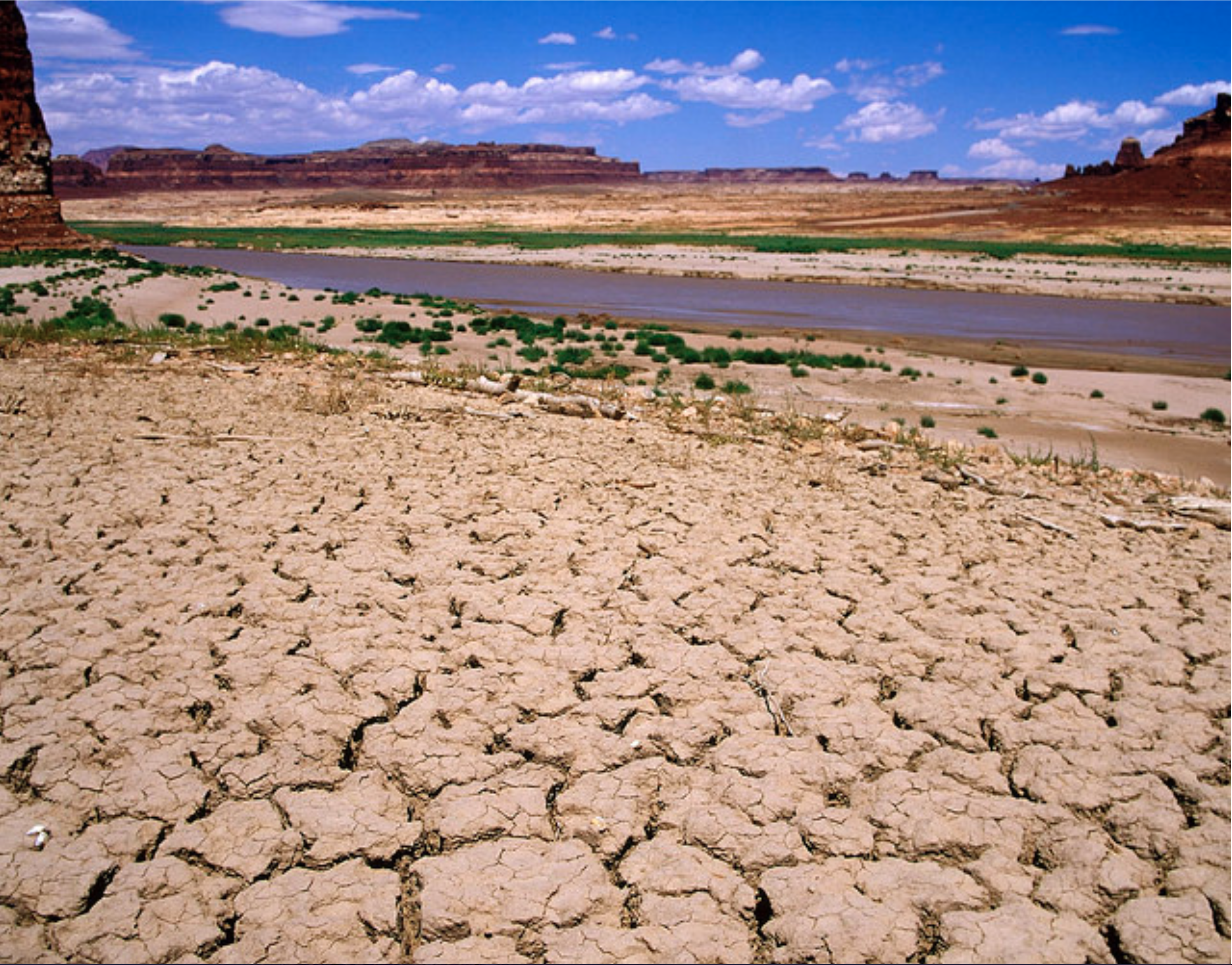
…this shift since the start of the century toward greater aridity also is forcing, out of public view in government meetings and science labs, an unprecedented scramble to determine how much climbing temperatures — compared with Colorado’s near-record low rain and mountain snowpack — are driving that change.
Quantifying the impact of rising heat is crucial to anticipate future water supplies, state planners and utility officials say. And it may help resolve an intensifying conflict in which some water users embrace reservoirs as necessary, though destructive, to enable more population growth and irrigation agriculture — even as water conservation makes huge gains in Colorado.
Environmental groups reject the idea of creating new reservoirs and are fighting multiple Front Range projects. Colorado already has more than 2,000 reservoirs. And, they note, draining rivers kills already-stressed Western ecosystems.
“The reservoirs really pay off,” state water czar John Stulp said last week after the latest multi-agency Water Availability Task Force meeting. Yet rather than expand storage beyond current projects, Stulp and Gov. John Hickenlooper continue to emphasize a conservation approach of using existing supplies more efficiently…
As usual around the end of summer, Colorado farmers, ranchers, industries and city dwellers last week were drawing down the state’s existing reservoirs, such as Denver Water’s Lake Dillon, where siphoning through a 23-mile mountain tunnel to slake city thirsts and controlled releases to meet legal obligations downriver dropped the water level to 85 percent full, compared with the 91 percent norm in September.
The reservoir drawdowns are bigger in other parts of western Colorado, with the massive Blue Mesa Reservoir west of Gunnison only 39 percent full, reflecting the low stream flows and demands of 40 million people across the Colorado River Basin. The latest data show combined water storage in Colorado River reservoirs at 47 percent of capacity.
However, other major reservoirs in Colorado remain relatively full with surpluses from last spring and in-flow of water offsetting withdrawals. Northern Water officials said their reservoirs supplying high-growth Front Range cities and farming measured 111 percent of normal for this time of year. Similarly, the John Martin Reservoir in southeastern Colorado was at 140 percent and Pueblo Reservoir was at 125 percent of the norm. Recent rain on the Eastern Plains has enabled late planting of wheat.
Statewide, federal data show reservoir storage at 82 percent of normal for September, which is about half full. Few have gone dry.
But as reservoirs serve their purpose of minimizing suffering during dry times before refilling in spring, the low flows in rivers are changing the environment — and causing more damage in some places than the toxic drainage from metal mines. Southwestern Colorado’s Animas River, for example, has dwindled to a record-low trickle before it disappears in New Mexico. Tens of thousands of fish have died…
Rising temperatures
Conservation gains in recent years enabled population growth with more people and producers surviving on less water despite hotter, drier conditions.
But Colorado officials are trying to make sure a growth and development boom can continue. Taryn Finnessey, the state’s senior climate change specialist, oversees more-or-less continual monitoring of precipitation, stream flows and reservoirs…
The average temperature in Colorado has increased by about 2 degrees Fahrenheit over the past century. National Weather Service meteorologists also have measured a trend toward more days where highs reach 90 degrees or hotter. (In metro Denver, temperatures hit 90 or higher on 56 days so far this year, and four of the five years with the highest average temperature on record were after 2006.)
A widening body of research focuses on how much this increased heat, compared with precipitation, affects water levels in rivers — due to increased evaporation and transpiration from plants. A study released last month found that higher temperatures caused 53 percent of the overall 16 percent reduction of water over the past century in the Colorado River — three times more than previously believed.
“You have a greater atmospheric thirst because the air is warming. And plants use more water because it is warmer. And the plants have a longer growing season,” said study author Brad Udall, senior scientist at Colorado State University’s Colorado Water Institute.
“What is a surprise is the magnitude of the loss,” Udall said.
“We’re seeing, even in systems where we get average snowpack, less water flows because of the high temperatures. More evaporation is occurring,” said Ted Kowalski, director of the Walton Family Foundation’s Colorado River Initiative. “Even where we see average snowpack, we’re getting less water.”
Climate scientists anticipate continued increasing temperatures due to the unprecedented, rising global concentrations of heat-trapping greenhouse gases from burning fossil fuels, which has led to carbon dioxide levels topping 410 parts per million.
Build more reservoirs?
The low flows in waterways raise questions about the viability of new reservoirs, even if there was a consensus to build them.
“Reservoirs are very handy when you have big swings between wet years and dry years. They no doubt are useful. The question is: Can building more reservoirs translate to having more water available year after year? In a lot of places, we don’t have the water flows to fill reservoirs. I’m skeptical,” said Douglas Kenney, director of the University of Colorado’s Western Water Policy Program and chairman of the Colorado River Research Group.
“You can build more reservoirs. But if you don’t have the water to put in, then it does no good. … There is certainly some logic to the argument that we need to be able to capture water in the really wet years so that we can get through the dry years,” Kenney said. “The reality is the West is just becoming drier.”
Hotter, drier conditions in the South Platte River Basin that Denver Water relies on have led to increased siphoning from Lake Dillon through the 10-foot diameter Roberts Tunnel under the Continental Divide. Recreational boating marina crews, noting that they have seen worse drawdowns, adapted by reconfiguring their docks. Denver Water officials said most of the drawdown is due to releasing water from the reservoir to senior water rights holders downriver.
Denver Water manager Jim Lochhead has encouraged conservation and efficiency but also favors significantly increased storage capacity strategically spread across mountain basins.
A current imbalance in where Denver draws water “underscores the need and importance of the Gross Reservoir Expansion Project (in western Boulder County), which is in the final stages of approval after nearly 15 years of permitting,” Lochhead said. “When it is completed, Denver Water will have more flexibility throughout our system to react to year-to-year changes in snowpack levels, extreme weather swings and unbalanced conditions across the state.”
“A rough, dry summer”
Agriculture accounts for more than 85 percent of the water used in Colorado. Livestock producers have adapted to low flows by reducing or liquidating herds. Farmers lacking sufficient water have planted fewer crops and improvised to fulfill contracts…
Environmental advocacy groups raise concerns that too much alarm could whip up sentiments for building more reservoirs.
From The Pagosa Sun (J. Williams):
[ed. I could not find a deep link for the article]
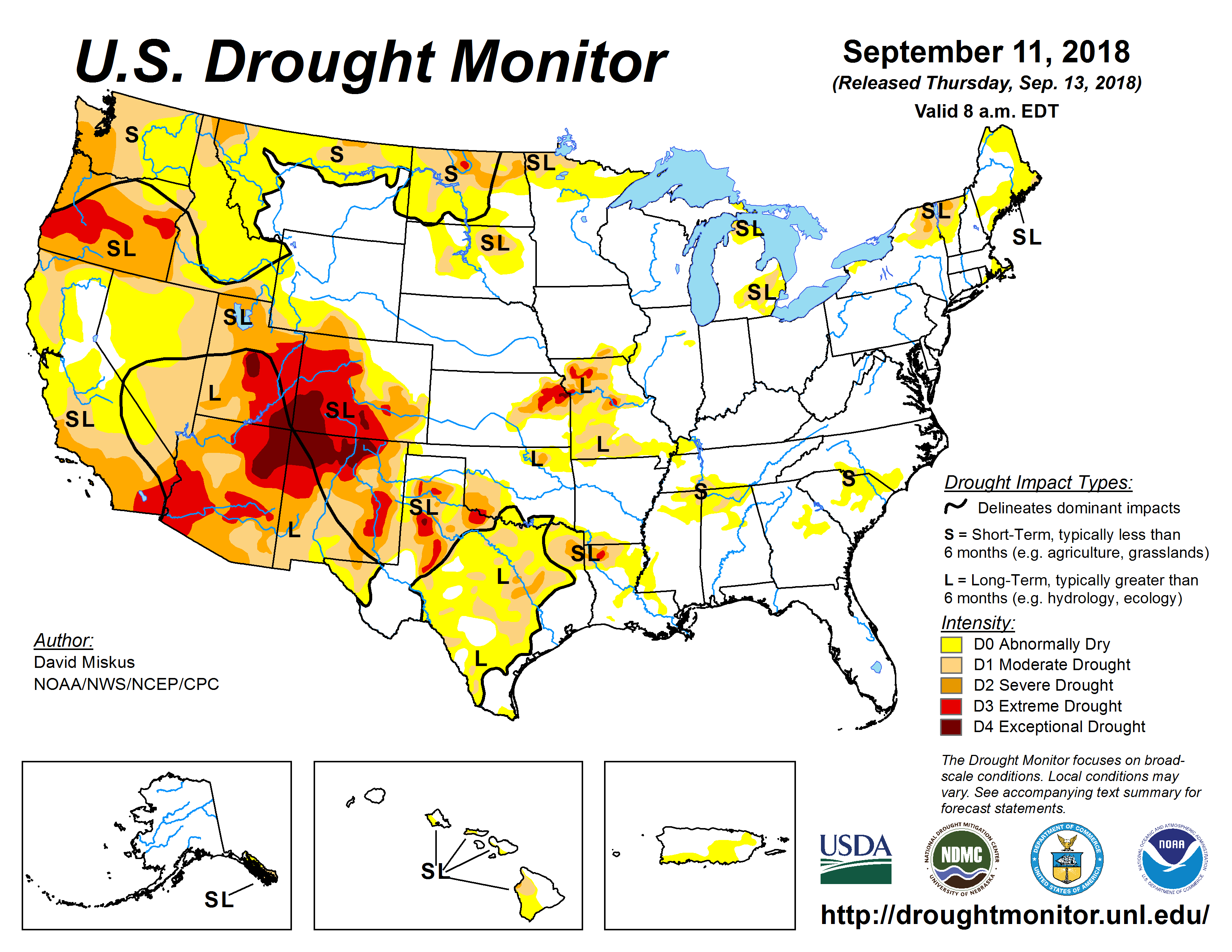
Successive years of extreme drought conditions, combined with ongoing economic growth, have sent up red flags for Colorado River District (CRD) officials to alert residents that our water sup- ply is definitely in danger.
“It will continue to be a slow-moving train wreck if we do nothing,” said the CRD’s general manag- er, Andy Mueller, during last week’s statewide webinar for journalists and community leaders.
Statistics presented during the webinar show that reservoirs in the Colorado River Basin are drastically below normal levels, with no im- mediate relief in sight.
The CRD is comprised of 15 Western Slope counties cover- ing about 29,000 square miles of Colorado.
Although the CRD does not directly include Archuleta County and the southernmost part of the basin that encompasses the San Juan River and its tributaries, officials noted that anything involving 28 percent of Colorado’s agriculture and industry will definitely impact everyone in the western United States.
For example, the Colorado River directly feeds Arizona’s Lake Powell, the largest reservoir in America’s southwest. Due to extreme conditions, Lake Powell is now at levels less than 50 percent of where it was in the year 2000.
“We’re talking about a dwindling water supply that will affect millions of Americans,” said Mueller.
To that end, the CRD is working closely with the U.S. Department of the Interior to explore a number of contingency options in case water usage continues to rise while supply continues to decline.
Mueller said that the CRD is insistent, however, that, “We know we have risks ahead, but we do not want to sacrifice economic growth. And, we do not want to simply put the burden of water conservation on Western Slope agriculture [which accounts for over 65 percent of Colorado’s water usage]. Our job is to find creative and cooperative ways to grow without increased water usage beyond what we can safely sustain.”
Among ways the CRD has sug- gested improving Colorado’s agricultural water usage are numerous suggestions to improve irrigation systems to make our state’s farms and ranches more “water efficient.”
Some of the proposed ideas will require additional capital investment in state-of-the-art irrigation equipment. However, officials are quick to note that other suggestions will simply require a few adaptations to improve upon “the old ways” of doing things, such as better irrigation schedules and planting strains of crops that are better adapted to Colorado’s climate to require lower water needs.
It isn’t just the agricultural use that is concerning. Municipal water use taps in to about 25 percent of the state’s water supply and CRD officials point at several “commonsense practices” that munici- palities and consumers can use to stretch water resources.
Chris Treese, the CRD’s external affairs manager, said, “It is critically important that we all work to save water in our homes and in our day-to-day lives, especially since half of the water we use is typically in discretionary activities such as watering gardens and lawns, filling swimming pools and washing the car.”
Treese said he hopes that “Water can be conserved by just making some simple adjustments such as using automatic shut-off faucets when washing the car or implementing irrigation timers when wa- tering the lawn. And, just simply re-thinking what type of landscaping we really want around our homes that would give us all the beauty we want with Colorado-adapted plants instead of wall-to-wall Kentucky bluegrass that requires so much more water.”
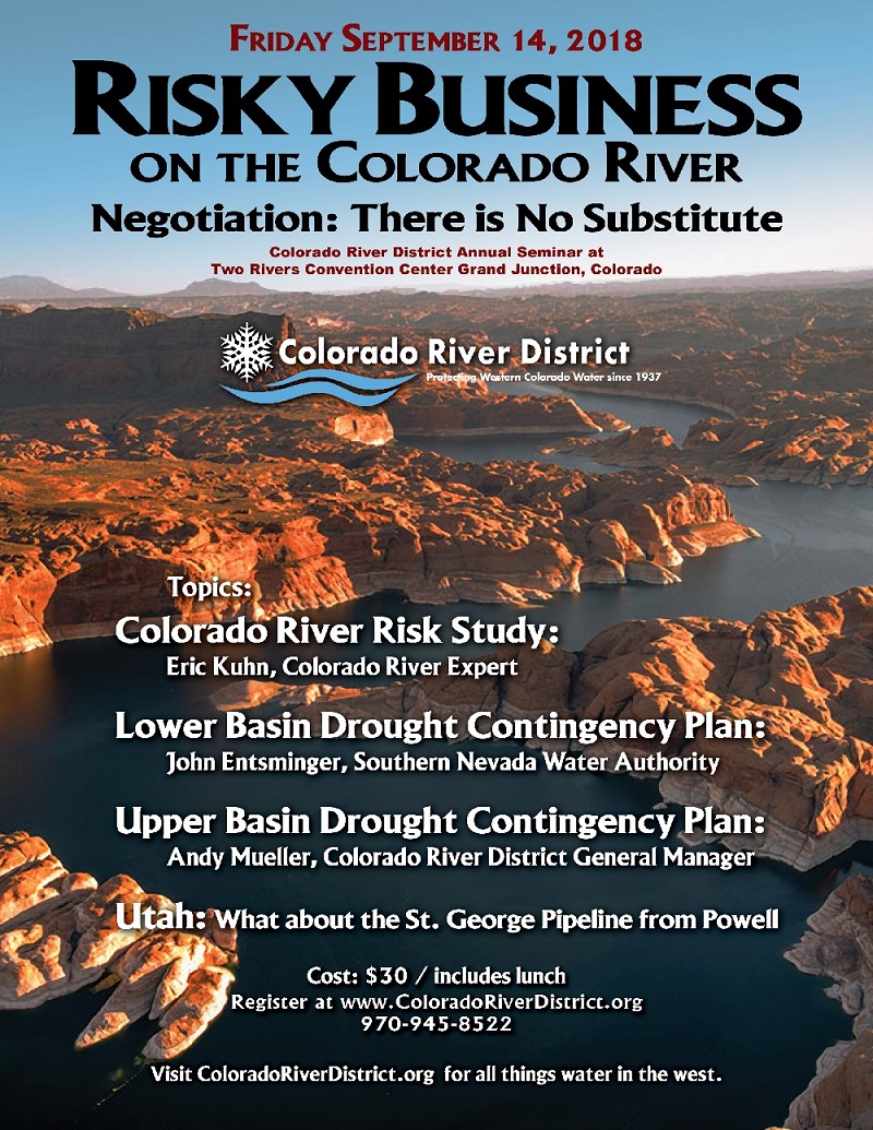
Further conversation on the subject will continue at the CDR’s annual seminar titled “Risky Busi- ness on the Colorado River” on Friday, Sept. 14, in Grand Junc- tion. David Bernhardt, deputy secretary of the U.S. Department of the Interior, will be the featured speaker. Registration information is available on the CDR website at: http://ColoradoRiverDistrict.org.
Meanwhile, here are just a few examples from the CDR on the many ways we use water and how much is used in our everyday life where just some minor lifestyle modifications could make a big difference:
• Brush your teeth? — 2 to 5 gallons.
• Wash the car? — 50 gallons.
• Use the dishwasher? — 8 to 15 gallons.
• Flush the toilet? — 1.5 to 4 gal- lons (each flush).
• Take a shower or bath? — 17 to 24 gallons.
• Run the washing machine? — 35 to 50 gallons (each load).
From The Pagosa Sun (Chris Mannara):
Slowly but surely, cumulative lake levels are dropping, but Pagosa Area Water and Sanitation District (PAWSD) customers have still not seen any stage 1 mandatory drought restrictions.
According to a Tuesday press release by PAWSD District Man- ager Justin Ramsey, cumulative lake levels currently sit at 70.6 percent.
This is down from the 72.5 percent total from last week.
When the cumulative lake level percentage hits 70 percent, stage 1 mandatory drought restrictions will “limit outdoor irrigation to the hours between 9 pm and 9 am and trigger a Drought Surcharge of $7.68 per Equivalent Unit (an Equivalent Unit is a single family home),” according to Ramsey’s press release.
Ramsey noted in an interview with The SUN that PAWSD customers are close to those stage 1 mandatory drought restrictions.
“It’s inevitable, though,” Ramsey said.
Lake levels
Ramsey’s report notes that Hatcher Lake is 62 inches from full and Stevens Lake is 127 inches from full.
Lake Pagosa is 24 inches from full, while Village Lake is 8 inches from full and Lake Forest is 15 inches from full.
Diversion flows and water production
Currently, according to Ramsey’s press release, the West Fork has a diversion flow of 3 cubic feet per second (cfs).
The San Juan River has a diversion flow of 1.5 cfs, while Four Mile remains at zero cfs.
Last year, in the time frame of Aug. 24 through Aug. 30, the cumulative water production by PAWSD customers was 15.69 mil- lion gallons.
This year, in that same time frame, water production sits at 17.15 million gallons.
In that time frame last year, Hatcher Lake produced the most with 11.16 million gallons.
This year, Hatcher still produced the most out of the Snowball plant and San Juan River plant, but the total is only at 6.26 million gallons in this time frame.
Additionally, this year in that time period, the San Juan River has produced 5.84 million gallons of water.
Last year in that same time period, the San Juan River plant was not producing any water.
Even after the necessary triggers were met to enter stage 1 drought restrictions, the Pagosa Area Water and Sanitation District (PAWSD) board decided during a special meeting Tuesday to not enact stage 1 drought restrictions yet.
According to a press release sent to The SUN on Sept. 10 by PAWSD District Manager Justin Ramsey, cumulative available lake water for treatment and delivery sits at 69.7 percent.
The trigger for stage 1 mandatory drought restrictions is for the cumulative lake water levels dropping at or below 70 percent, according to the district’s drought management plan.
Stage 1 mandatory drought restrictions would “limit outdoor irrigation to the hours between 9 pm and 9 am and trigger a Drought Surcharge of $7.68 per Equivalent Unit (an Equivalent Unit is a single family home),” according to the release.
During the meeting, Ramsey explained that when the cumulative lake water levels hit, he met with Colorado Division of Water Resources Lead Commissioner Joe Crabb.
The call that had been placed on the Four Mile diversion had been anticipated being removed the middle of this month, Ramsey noted, but according to Crabb, one of the “unintended consequences” of the Colorado Water Conservation Board’s (CWCB) call on the San Juan River was that the ranchers were scared by the call and now the Four Mile call is anticipated to be on until November.
“The concern is that when the CWCB did the call on there it just put the fear in them that their water is going to be pulled from them. So, they’re keeping the water and they’re just super saturating all their fields for the winter,” Ramsey said, noting this was just Crabb’s theory and it was not “set in stone.”
Usually by Oct. 1 the call is removed, Ramsey noted, stating, “this has never happened before.”
“And the scary thing about that is that’s about the time we start seeing freezing and so we lose that water,” Ramsey explained.
Board member Gordon McIver moved to enter stage 1 restrictions; however, board member Glenn Walsh, participating in the meeting by phone, raised some concerns.
“I’m not spooked by the 70 percent in the middle of September. I’d be much more spooked by, say, 85 percent on April 1,” Walsh said.
Walsh noted that he probably would not vote for PAWSD to enter into restrictions because he doesn’t see PAWSD saving any water.
This could look to PAWSD customers like PAWSD is just looking to make money rather than save water, Walsh noted.
PAWSD could stay in voluntary drought restrictions and keep a “close eye” on snow water equivalent and if it is a terrible season like 2002, PAWSD could potentially enter next year in stage 1 or stage 2 drought restrictions, Walsh suggested.
“If we go into drought restrictions every year, we’re just going to be making the case for a reser- voir,” Walsh said.
However, if PAWSD decides to implement the maximum amount of pumping to keep the highest levels it can at the reservoirs, Walsh explained that he wanted to make sure that PAWSD can cover those costs.
Late May is usually when PAWSD is cut off from Four Mile. This year, PAWSD was cut off April 12, which is the earliest PAWSD has ever been cut off, Ramsey noted.
Ramsey noted he hoped to turn the San Juan plant off this month be- cause of how expensive it is to run it.
Ramsey noted that PAWSD had paid $50,000 and $40,000 for electri- cal and chemical costs for the San Juan plant.
PAWSD Chairman Jim Smith noted that he had people ask him what PAWSD is going to do about the drought.
“I am still a little spooked simply because they’re going to wait so long to turn that on,” Ramsey said in reference to being able to use water from the Four Mile diversion.
Waiting until November scares Ramsey more than the lake levels being at 70 percent, he noted.
Board member Paul Hansen, also participating by phone, noted that he agreed with Walsh, suggesting a “wait-and-see policy.”
“I don’t think we should pull the trigger on it right away because it’s so late in the season,” Hansen noted.
Board member Blake Brueckner noted that he felt like it was a little too late in the season to go into drought restrictions.
The restrictions also help offsetting costs of the drought, Ramsey noted, adding that the $7.68 sur- charge could bring PAWSD $50,000 a month.
The Snowball plant costs about $600 for 1 million gallons of water, while the San Juan plant costs $6,000 for that same amount of water, Ramsey stated.
“Yeah, we might need extra money to cover that, but it shouldn’t go with the drought. Because if you start doing drought then people will go back to, ‘Oh well, we need more water storage then, if we’re going into drought,’” Brueckner said.
Ramsey noted that he hopes this situation is not the “new norm.”
“I’m patient. I don’t mind waiting a month,” Brueckner stated.
However, PAWSD Comptroller Aaron Burns pointed out that PAWSD had not budgeted for running the San Juan plant much longer than it already has been.
“I just don’t want to ignore the reality for, you know, of operating this thing,” McIver said.
The motion to enter into stage 1 restrictions failed via a 3-2 vote.
Smith and McIver voted for the motion, while Brueckner, Hansen and Walsh voted against it.
The item will be discussed again at the board’s Sept. 20 meeting.
After the formal vote, community member Al Pfister spoke.
“As a ratepayer, I would’ve appreciated that you actually implemented the stage 1,” Pfister said. Keeping PAWSD more economically balanced and educational purposes were reasons cited by Pfister for going into restrictions. “Regretfully, the only way you can talk to people is through their wallet,” Pfister said.
Walsh later suggested that the surcharge could be smaller or a lump sum to meet additional pumping requirements
.
“I’m not a punish-the-customer type of board member,” Walsh said. “I don’t think any of us are. I think our record shows that,” McIver responded.
Lake levels
Ramsey’s press release notes that Lake Hatcher is 67 inches from full while Stevens Lake is 129 inches from full. Last week, Hatcher was 62 inches from full while Stevens was 127 inches from full.
Lake Pagosa is 24 inches from full ,while Village Lake is 8 inches from full and Lake Forest is 15 inches from full. The totals for those three lakes remain unchanged from last week.
“And the reason for that is we’re pumping water into Forest Lake, so everything we’re pulling out of there at the San Juan Plant we’re basically replacing from the San Juan diversion,” Ramsey explained in an interview.
Lake Pagosa and Village Lake are being fed from Stevens Lake, Ramsey noted.
Water production
Last year, from Aug. 31 through Sept. 6, between the Snowball plant, Hatcher Lake and the San Juan River plant, water production was 15.69 million gallons. In that time period last year, Hatcher Lake contributed 84 percent of the water production with 13.24 million gallons. Snowball produced the other 4.76 million gal- lons last year.
This year, in that same time frame, water production is 17.15 million gallons.
Water production is much more spread out this year, with Snowball producing 5.39 million gallons, Hatcher producing 4.39 million gallons and the San Juan plant producing 6.87 million gallons.
Ramsey noted that the numbers were surprising because water production usually goes up in July and back down in August, but not this year.
“Our August numbers were actually 200,000 gallons less this August than last year, where last year our drop, I think their drop was like 3 million gallons,” Ramsey said.
Ramsey attributed these numbers to the lack of monsoon moisture.
After completing its final PFAS Community Engagement event in Leavenworth, Kansas, on Sept. 5, the EPA plans to prepare its PFAS management plan and release it by the end of the year.
The first community engagement event was in Exeter in June, with follow-ups in Horsham, Pennsylvania, Colorado Springs, Colorado, Fayetteville, North Carolina and an event for tribal representatives in Spokane, Washington.
The EPA said, “The Community Engagement events and the input the agency has received from the docket for public comments have been incredibly informative and will be used, along with perspectives from the National Leadership Summit to develop a PFAS management plan for release later this year.”
[…]
While the EPA says one of its actions will be to evaluate the need for a MCL for PFAS that may change its current level of 70 parts per trillion that is a health advisory…
Many environmental groups are calling for lower levels that have already been established by other states.
FromWestern Slope Now (John Madden). Click through for the TV footage:
Since there is no substitute for water, many gathered at the Two Rivers Convention Center to discuss current conditions of the river, and plans by western states on what to do to protect our water supplies.
The Colorado River District held their 2018 Water Seminar focused on the Colorado River.
They discussed handling the growing demand for water, how other states like Utah use the river, plans to combat drought, and climate change conditions.
The seminar went over several studies including one that looked at how Lake Powell could be drained if the current drought continues and how that would impact Colorado.
FromThe Grand Junction Daily Sentinel (Dennis Webb):
The general manager of the Colorado River District on Friday voiced strong criticism over what he fears is a lack of transparency when it comes to discussions over how to manage water in response to drought.
Andy Mueller raised his concerns during a district water seminar in Grand Junction that focused on contingency planning measures aimed at responding to the potential of a continuation of a long-term drought within the river basin.
Mueller specifically cited the district’s understanding that Colorado and other states may execute a series of documents as soon as the end of the month, including a demand-management plan for states in the Upper Colorado River Basin.
“We have a very serious concern that we haven’t seen the demand-management document. We haven’t seen what it is our Upper Colorado River commissioner is potentially going to sign within the next month,” Mueller said.
He worries that the result could be an agreement that is harmful to western Colorado water users, particularly in the agricultural sector.
“We haven’t seen those documents that are about to be executed. We’ve been told that we don’t need to see them. We’re not OK with that. We don’t think it’s acceptable. We think those documents need to be shared with us and frankly the impact of those documents needs to be shared with the water users of the Western Slope and the state of Colorado,” he said.
Colorado’s representative on the Upper Colorado River Commission is James Eklund, an attorney with family ties to the Collbran area and a former director of the Colorado Water Conservation Board.
Reached for comment Friday, Eklund expressed surprise about Mueller’s concerns, and said the river district and other interested parties will have plenty of opportunity to provide input before things are finalized.
“We are not in any way rushing to get something inked that he and the (river) district and the other advisers in the state on Colorado River issues don’t get a full chance to evaluate and look at and analyze,” he said.
He also provided a different timeline than Mueller did, saying the goal is to get documents ready for review by interested parties by the end of this month, allowing for subsequent consultation with them, with a goal of wrapping up agreements by the end of the year.
He said those parties have been involved all along the process, and that will continue to be the case…
Mueller’s concerns arise over drought contingency planning to respond to falling water levels in Lake Powell. That reservoir is used by Upper Basin states to meet water-delivery obligations to Lower Basin states under a 1922 compact. The river district and other entities are looking at demand management as one means of trying to shore up water storage in Powell to avoid a compact call on Upper Basin holders of post-1922 water rights to meet downstream obligations.
The river district supports the idea of a demand-management program, which could involve measures such as temporary fallowing of lands by agricultural producers, as long as the measures are voluntary and compensated, and the burdens of reducing demand are shared proportionally among all users.
One concern for the river district is that while Colorado Water Conservation Board staff have expressed similar thoughts on the matter, a memo the staff prepared for the board for its meeting next Wednesday says that key issues to be considered include whether a demand-management program should be limited to temporary, voluntary and compensated activities “or be expanded to include something more.”
“What is that expansion? Who is it that’s calling for the expansion? It’s not the West Slope, I can tell you that,” Mueller said. “We don’t think it should be expanded to an involuntary uncompensated mechanism of reducing water use.”
Also of concern to the river district is the memo’s raising the question of whether the program would be used to help assure continued compliance with the river compact “or something more.”
Mueller thinks some Front Range operators of transmountain diversions want to set up individual accounts within the pool of water created through demand-management efforts so that after a compact call occurs they can protect their own diversions while West Slope users get shut off.
He’s likewise concerned about a reference in the memo to the issue of trying to understand “the extent to which the state would engage and work in tandem with stakeholders on rules for compact administration before considering a pivot from temporary, voluntary, and compensated demand management to something more akin to mandatory curtailment.”
Mueller said the idea of mandatory curtailment of use has never been discussed by water roundtables around the state.
“It’s one that needs to see the light of day and we need to understand it before the state signs those demand-management documents,” he said.
Eklund sees such matters as intrastate issues to be resolved within the state of Colorado. His focus at the interstate level when it comes to the demand-management program is to reach an agreement under which conserved water can be stored in Powell in a separate account rather than just being subject to downstream release under existing agreements.
Without such an agreement about where to put the water, he views the discussion about what constraints and sideboards such a program should have in Colorado as being meaningless.
“I think our focus at the interstate level, my focus on behalf of the state of Colorado at that level, is on making sure that we have the table set for the discussion, so that it’s not just an academic, theoretical discussion,” he said.
Mueller said the river district’s concern is that creating a place to put water for a demand-management program ahead of creating the program’s sideboards and rules could lead to wealthy, Front Range water interests using the pool “for very different purposes” than just avoiding a compact call.
Click here to view the Twitter hash tag #crdseminar for all the real-time coverage from the seminar.
Using dynamic forecasting models, climate scientists like Andreas Prein are looking at how intense rainstorms are changing over the coming decades.
Prein, a climate modeling scientist at the National Center for Atmospheric Research in Boulder, said warmer climates are leading to more frequent heavy rainfalls. Since 1950, the number of three-inch rainfalls in a day has increased about 25 percent across the U.S., according to Chad Gimmestad, senior forecaster for the National Weather Service Office in Boulder. Prein explained that the warmer air holds more moisture, so when rain falls more water is dumped than normal in cooler conditions.
“We have stronger evaporation over the ocean because it’s warmer, and then this moisture is transported over the continent,” Prein said. “It is basically exactly what happened in 2013 during the Colorado flood.”
Looking at the regional trends, Gimmestad said the heaviest two rainfalls expected in a year have increased about 10 to 20 percent in the western U.S. In Colorado, where there were once a two-and-a-quarter inch rainfalls, forecasters see two-and-a-half inch rainfalls, he said. While that increase isn’t as large as it is in the eastern U.S., where the heaviest rainfalls in a year have increased from 30 to 60 percent, it still has a significant effect.
“That’s when your flood occurs, so you just made your flood 10 percent bigger,” Gimmestad said..
Prein said the Front Range’s major flood events are often related to a stream of moisture from the Gulf of Mexico from the south traveling north along the mountains and turning west to create upslope flows. As the mountains push the moist air upwards, the heavy rainfalls are practically anchored by the mountains. Gimmestad, who commuted from Greeley to Boulder during the floods, said forecasters knew something big could happen from the weather patterns in 2013, but seeing it was something else. Gimmestad drove to Boulder on the night of Sept. 12, the second night of the heaviest rain during the flood. After about three hours of driving around, he found the one bridge still above the water over Boulder Creek. By the time he drove back to Greeley the morning of Sept. 13, he had to go out to Kersey because everything upstream on the Platte had flooded…
Laura Read, a water resources engineer at the National Center for Atmospheric Research, said the heavy rainfalls led to sustained flooding because of the Front Range’s relatively flat topography next to the steep gradient of the foothills. Residents in areas like Milliken didn’t see the flooding go down for as long as two weeks because the flood brought the groundwater table up, she explained. As the water came up from the ground from the 2013 flood, it caused additional damages to structures…
Brad Udall, senior water and climate research scientist at Colorado State University’s Colorado Water Institute, said scientists of just a few years ago were asking the wrong question about climate change’s effect on extreme weather events. Where scientists before framed the conversation about whether or not climate change caused extreme weather, they’re now looking at how it impacts these cyclical events.
“Climate change may not have caused them, but they add to their intensity. It adds to their frequency. It can add to their duration,” Udall said.
Scientists are still hashing out the degree to which climate change impacted the 2013 flood, Udall said. Heavier rainfalls, drier soils and growing risk for wildfires — which leads to more erosion, Read explained — are expected with the warming climates, experts said. Though there’s not yet enough data to definitively say whether these conditions will lead to more events like the 2013 flood, Udall said climate change is creating unprecedented weather events.
“We’re now in an era, because of climate change, where all the sudden our predictability has gone away,” he said. “We need to be prepared for really bad outcomes.”
Flood damage Big Thompson Canyon September 2013 — photo via Northern Water
The fast-moving water as a result of a storm system stalled over the Front Range inundated parts of Loveland, Lyons, Greeley and Boulder. Fort Collins saw little damage, though the flood temporarily impacted the ability to get in and out of the city.
Nine deaths were attributed to the flooding — two in Larimer County — and an estimated 2,000 homes were damaged or destroyed statewide, according to a Coloradoan report at the one-year anniversary of the flood. Parts of U.S. Highway 34 and other roadways were washed away.
The September 2013 flood ranks among the worst natural disasters in Colorado history, according to reporting during that time. The flood changed the landscape of Northern Colorado and led to years of rebuilding, including projects that just wrapped up this year.
Here’s a photo gallery from The Fort Collins Coloradoan.
Bear tracks in the mud near Big Thompson River west of Loveland via Craig Young
The evidence can be seen in a new network of water gauges, a bolstered mass-notification system, and in the memories of residents five years after the 2013 flood rushed into Loveland. The wisdom will be useful if — more likely, when — another flood takes place in Larimer County.
“Floods are part of life here,” said Loveland Fire Rescue Authority Capt. Pat Mialy as she sat down with a 3-inch-thick binder titled “Flood Master Plan.” “Loveland is built at the bottom of a canyon; some things we can do nothing about, but we can help people become more prepared.”
Mialy, who is also Loveland’s emergency manager, said the city has an integral part in the Flood Master Plan, which encompasses the Big Thompson’s entire path through Larimer County, not just the flow at the mouth of the canyon.
Watching water
Mialy said zooming out and viewing Loveland as a part of other communities marks one of the key differences between the 2013 flood and the next inevitable flood. After all, storms don’t care about ZIP codes.
“We’re listening to Estes Park, we’re listening to Glen Haven,” Mialy said, alluding to a network between agencies that have strengthened ties since 2013. “All our flood systems were integrated; they all speak to each other.”
A network of gauges and number crunchers watches over Loveland and other Larimer communities. The county’s floodplain administrator, Eric Tracy, said if there’s heavy water upstream, he knows about it.
Tracy told the Reporter-Herald that in the 2013 flood, waters washed away the only U.S. Geological Survey water level gauge monitoring flow through the Big Thompson Canyon, and with it, any doubts that the county needed better ways to watch the water.
“It was a very reactive approach before 2013,” Tracy said, motioning toward a pole-mounted camera at the U.S. 34 bridge near Sleepy Hollow Camp. He said the Colorado Department of Transportation uses it to get video footage of the bridge, but that means almost no upstream warning when a flood might overtake the road or worse, wash it away.
Tracy said that, ironically, he and many other flood plain administrators were in Steamboat Springs for a convention the day the 2013 flood ripped through Larimer County. He rushed back as fast as he could to handle the damage…
“The next six months were a nightmare,” Tracy said, noting that his cellphone was a nonstop stream of emergency notifications at that time.
Now, his cellphone still gives him notifications as water moves around the canyon, but he gets them hours before a flood event, when preventative measures can be ordered. Different monitoring locations are programmed with low-, medium- and high-priority warnings that all reach Tracy’s phone, as well as many other devices.
That’s because today, the bridge over Sleepy Hollow, among other locations, has some new gadgets.
“It’s a tipping cup,” Tracy said, now pointing to the top of a metal pole in the ground. He explained that the cup acts as a rain gauge: when it fills up to a certain amount, it tips over. It then counts the number of tips over time and transmits that data back to the county.
Also new is a water pressure transducer, which measures the depth of the water based on the pressure.
Another gadget, mounted on the side of the bridge, bounces sonar off the surface of the river to measure real-time water levels, Tracy said. Best of all, that sonar detector won’t wash away unless the bridge does.
The measurements mean numbers, and those numbers — in the hands of civil engineers such as Tracy — mean real-world information. Combining the data with a geomorphic map of the flood plain, and the county can figure out when and where flooding will occur.
Now, new rain and water flow gauges have been placed at several places in upstream Larimer. According to Tracy, water gauges exist at Sleepy Hollow Camp, Olympus Dam, Mary’s Lake Road, Fall River, Devil’s Gulch, Glen Haven and Drake, among others in rural water flow areas.
“The data will help the National Weather Service ground truth on what they see on their radar systems and will assist in the accurate execution of weather alerts for the Big Thompson basin,” Tracy said. ” The data will also be used in real time in the Emergency Operations Center for large flood events to assist emergency personnel and road and bridge crews in the field.”
Mialy said Loveland authorities are privy to the same information, and they can view it on a dashboard with other agencies.
Lori Hodges, director of Larimer County’s Office of Emergency Management, said the 2013 flood marked a large shift in the county’s emergency preparedness — it also marked a change in her career.
“What’s new since 2013?” Hodges reflected, “Well, my office didn’t exist in 2013. … I was hired because of the flood.”
Hodges said that day one on the job, she updated the county flood plan to reflect the Larimer County Sheriff’s Office’s request for a broader plans, both geographically and socially.
“Before it was a response-based program,” Hodges told the Reporter-Herald. “They needed to look more broadly at mitigation.”
Part of that mitigation means preparing the public for an emergency flood and keeping them away from danger areas.
Sometimes, preparedness is as simple as knowing your neighbors, Hodges said. In the wake of both the 2013 flood and the 2012 High Park Wildfire, both of which called for federal emergency aid, Larimer County created Larimer Connects, a program designed to bridge gaps between county residents.
According to the program’s website, Larimer County has had the most federally declared disasters in Colorado; the website goes on to say that with a track record like that, it’s necessary for Coloradans to expect the worst, especially in unincorporated areas such as Glen Haven and Red Feather Lakes, both of which have created emergency plans since previous disasters.
Larimer Connects offers assistance in creating community hubs such as the North 40 Mountain Alliance, a self-sustaining nonprofit group surrounding Red Feather Lakes.
“The one thing we really did learn from the flood is that when communities are more connected, the better they do when there was a flood,” Hodges said. “It’s social capital; that will cause people to recover faster and better.”
Larimer Connects intends to build resilience within communities by connecting them to resources and each other.
Hodges said that ironically, densely populated areas such as Loveland and Fort Collins have less social capital; neighbors aren’t as tight or reliant on one another, meaning disasters can cause even more disruption.
Everbridge over troubled waters
Mialy said agencies within the county have no problem notifying one another of impending floods — thanks to the new data network — but that’s not enough: Residents must also be aware.
Since the 2013 flood, Loveland has urged residents to sign up for the Larimer Emergency Telephone Authority LETA911 emergency notification system that alerts residents of oncoming or current dangers.
Mialy said the system works almost exactly like an Amber Alert, which automatically notifies all cellphones in a given area of an abduction or other threat.
The problem is, Larimer County doesn’t have the authority to push notifications unless residents sign up.
When signed up, the system uses Everbridge, a mass-notification system to show road closures, evacuation notices and other warnings to all registered devices.
Loveland Fire Rescue Authority emergency management specialist Lenny Layman said through that system, authorities can type a message and draw a polygon on a digital map. When they say “go,” that message is delivered to any and all devices set up within that polygon.
With this system, law enforcement or emergency responders notify the public of an incident before residents feel the need to call dispatch.
He said this could prove especially useful in the event of a flood, when authorities can figure out exactly which neighborhoods could end up underwater.
Users can set up for notifications at multiple addresses. For instance, parents can add their child’s school to the list so they can receive notifications even if they aren’t near an affected area.
Moreover, LETA911 can ping a multitude of channels, including email, landlines, pagers and cellphones using both calls and texts.
“The more information we can send, faster, the more lives saved,” Leyman said. “But you have to opt into Everbridge.”
Mialy said that in her eyes, Loveland has only become stronger since 2013, despite the fact that the city remains in disaster recovery mode.
“We can’t prevent natural disasters,” Mialy said. “But we can identify all our weaknesses.”
Evans Colorado September 2013 via TheDenverChannel.com
In the weeks leading up to September 2013, the Weld County Sheriff’s Office was in the midst of emergency preparedness training.
In a sense, they were ready when a slow-moving cold front stalled over Colorado on Sept. 9, dropping several inches of rain. By the 15th, there was widespread flooding across a 200-mile stretch of the Front Range, including as far south as Colorado Springs and as far north as Fort Collins. A state of emergency was declared in 14 counties, including Weld.
Although deputies were fresh off emergency preparedness training, Weld County Sheriff Steve Reams said the floods identified critical deficiencies in the county’s infrastructure, namely communications.
“That’s something you don’t see everyday,” Reams said. “You don’t think about potential communications problems when you’re working a normal day in law enforcement.”
Colorado’s shared statewide communications system for emergency responders, pushed for in the wake of the 1999 Columbine High School shooting and again following 9/11, was the first to go, Reams said. It became overloaded and essentially worthless as flooding affected Boulder County, then all of Larimer County and finally all of Weld County.
When deputies abandoned the statewide system, they moved to cell phones, their secondary mode of communication, Reams said. But callers from throughout the country trying to check in on loved ones clogged the towers. As a last resort, the sheriff’s office orchestrated a lot of its moves by text message.
“Obviously that’s not the best way to conduct business,” Reams said. “The county has since created its own radio infrastructure that allows us to operate on our own platform. The bandwidth in the county has never been better.”
In addition to coordinating emergency response, Reams said the department had issues connecting with off-duty deputies to get them to come into work. Each deputy now has their own county-issued cell phone, so they can be reached in a timely manner in the event of an emergency. The department has also established better employee tracking to know who is available, even officers who are off-duty.
“Everything came down to an ability to communicate,” Reams said. “Once one mode went down, we had to find another mode of communication. Then that went down.
“You can fix almost any problem as long as you have the ability to communicate about it.”
If communications issues weren’t enough, the 2013 floods also illustrated the sheriff’s office error in keeping almost all of its emergency equipment centralized in Greeley. As the South Platte River breached its banks, it damaged 122 bridges and more than 650 lane-miles of road.
“Every major north-south road with a river crossing was completely wiped out,” Reams said. “Balancing equipment needs was a huge challenge as trying to get equipment from the north part of the county to the south was impossible.”
The Sheriff’s Office has since made changes to where it stages emergency equipment throughout the county.
In the city things weren’t quite as chaotic, said Pete Morgan, current Greeley Fire Marshal and the city’s emergency manager at the time of the flood. Fortunately, Greeley had beefed up its public safety communications prior to the flood, including working with cellphone providers to establish priority access to its networks in the event of an emergency. The city has since increased the number of employees across a variety of departments who have priority access to those networks.
But Morgan said the floods did show the fire department’s Water Rescue Team, trained in underwater rescue operations, was not prepared for swift water rescue needs as a result of the flooding.
The department has since gone from zero swift water rescue technicians to 15, with another five set to get their certification in the next year. Every Greeley fire employee with a response job at least has their swift water operations certificate, which is one rung below a swift water rescue technician, Morgan said. The department also has two swift water rescue instructors to perform in-house certification training.
Every fire truck and ladder now carries equipment specific to swift water rescue.
“The benefit with the additional equipment and certifications is when a swift water call comes in, we don’t have to wait for the Water Rescue Team to gear up and come out to the scene,” Morgan said. “We can respond directly with any of our trucks and ladders to begin rescue measures.”
The city also created an Incident Response Team composed of Greeley’s police, fire, public works, water & sewer, public information, risk management, and information technology departments, among others. Representatives from each department meet and train regularly about how to coordinate response efforts.
Click here to read the update and to check out their graphics:
In response to persistent and prolonged drought conditions throughout the southern half of the state and along the western border, the Governor activated the Colorado Drought Mitigation and Response Plan for the agricultural sector on May 2, 2018, additional counties in northwest Colorado were added this month; information can be found HERE.
With only three weeks left in the 2018 water year, October through August of this year has been the third warmest and the fourth driest October through August period in the 123 year record. Warm and dry conditions continued to persist in Western Colorado in August and early September.
SNOTEL water year to-date precipitation statewide is 68 percent of average, but ranges from 49 percent of average in the Southwest basins to 86 percent of average in the South Platte River Basin. The Rio Grande is at 54 percent of average; while the Gunnison is at 58 percent. The Arkansas is faring slightly better at 63 percent, while the northern basins of the Colorado and Yampa- White are at 76 and 75 percent of average, respectively.
High temperatures, and below average precipitation have led to increasing water demand across much of the state. Reservoir storage, statewide is at 82 percent of normal, with the Arkansas, Colorado, Yampa- White, and South Platte all above 90% of average for the end of August, despite recent declines. Storage in the Upper Rio Grande basin is 88% of normal. The Southwest basins of the San Miguel, Dolores, Animas & San Juan, and Gunnison have seen significant decreases in reservoir storage and are now at 48 and 59 percent of normal, respectively.
Agriculture has been heavily impacted this growing season by both high temperatures, drought, and hail. Hay prices are higher than in the last few years and producers are concerned about finding enough feed for cattle resulting in continued sell off. The Governor is likely to issue an executive order relaxing restrictions on trucks carrying hay into Colorado.
Long term forecasts indicate an increased likelihood of above average temperatures for September through November. Southwestern Colorado is forecast to continue to benefit from additional monsoon moisture and has an increased likelihood of above average precipitation into Fall.
ENSO-neutral conditions are likely to continue through September with El Niño conditions likely to develop in the fall. El Niño could bring an increased chance of wet extremes for southeastern Colorado this winter.
Reservoir storage remains strong, 82% of average for the end of August statewide. Water users with access to storage, especially municipal water suppliers, have been able to avoid major restrictions on water use operations by relying on storage.
Western Colorado has seen above normal and record warm temperatures for the water year to date.
4th driest in 123-year record (behind WY 2002, WY 1934, WY 2012), -4.55” below the 16.67” average.
More than a million people are fleeing the Carolina coast ahead of Hurricane Florence’s impending landfall. When they return, the region they call home will likely be forever changed.
Hurricane Florence is an almost impossibly rare threat. A storm this powerful is exceedingly rare this far north on the East Coast. Never before has a hurricane threatened the East Coast with nearly four feet of rainfall. In just two cases since our records began in 1851 — Hazel in 1954 and Hugo in 1989 — has a Carolina hurricane provoked an 18-foot rise in the ocean tide.
In my two decades as a meteorologist, I can’t recall a single storm that threatened new all-time records in all three of these, simultaneously, anywhere in the world. Despite what some of my more hesitant colleagues might say, you can connect individual weather events to climate change in this day and age. Quite simply, Hurricane Florence is a storm made worse by climate change.
A warmer atmosphere can hold more water vapor — producing heavier downpours and providing more energy to hurricanes, boosting their destructive potential. We already have evidence of these trends from around the world. This is no longer just a theory.
The Carolinas are likely to join Texas, Florida, Puerto Rico, California and countless other places worldwide that have experienced such deadly weather over the past 12 months. On Tuesday, the U.S. Geological Survey issued a statement predicting that Florence could erode away protective dunes from three-quarters of North Carolina’s beaches. Like the otherworldly wildfire smoke that dimmed the British Columbia sun last month or the clear-day floods that routinely hit the Marshall Islands, this week’s potentially coastline-erasing landfall is a glimpse into a haunting world that has arrived too soon.
Since modern tracking began, no hurricane with its origins in the hundreds-of-miles-wide patch of the central Atlantic where Florence traveled has ever made landfall on the East Coast, or even come close. Thanks to unusually warm ocean waters, Florence has intensified at one of the fastest rates in recorded history for a hurricane so far north. Thanks in part to unusually warm ocean waters between New England and Greenland, the atmosphere has formed a near-record-strength blocking pattern — not unlike the one that steered Sandy into New York Harbor in 2012 — that is propelling Florence toward the Southeast coastline. Another blocking pattern, expected to emerge later this week over the Great Lakes, could lock Florence in place for days — which would result in an abject freshwater flood that could extend hundreds of miles inland.
For decades, hurricane scientists fretted about when the effects of climate change would become apparent. Tropical meteorology is tricky, and in the past the models have given conflicting results. But on the East Coast, the trends are more clear: Stronger hurricanes are happening more often, and farther north. They are bringing more rain, and — as the seas rise, their coastal floods are literally changing the shape of the coastline.
Photo of Lake Powell in extreme drought conditions by Andy Pernick, Bureau of Reclamation, via Flickr creative commons
FromThe Colorado Sun (John Ingold). Click through to read the whole Q&A, here’s an excerpt:
A Q&A with former Colorado Supreme Court Justice Gregory Hobbs, one of the state’s top water experts
Colorado’s system governing water use predates the state itself — the oldest water rights in Colorado date to the 1850s. And it is so closely linked to the state that, even when it is used elsewhere, it is often called the “Colorado Doctrine.”
But can it survive perhaps the greatest challenge in its history — a double-whammy of drought and population growth?
To answer that question, The Colorado Sun sat down with retired state Supreme Court Justice Gregory Hobbs, one of Colorado’s foremost minds on water law. Hobbs has 45 years of experience practicing water law in Colorado, and he continues to serve as a senior water judge and mediator.
First, some background: This spring, an influential water think tank, the Colorado River Research Group, released a report calling on water wonks to stop using the term “drought” to describe what is happening in the West. Drought implies something temporary, the report argued. But these changes show no sign of being temporary.
Greg and Bobbie Hobbs
“For that, perhaps the best available term is aridification, which describes a period of transition to an increasingly water scarce environment,” the group stated in its report.
Meanwhile, the Colorado State Demography Office projects that Colorado will add 3 million people by 2050, bringing the population above 8 million.
This is a worrying prospect for water in Colorado — party to nine interstate water compacts and home to thousands of individual water rights, each meticulously ordered in priority from oldest to youngest. And the strain may already be starting to show.
The fiscal year that ended in June 2017 — the most recent for which data is available — had the most claims and filings in state water court since the similarly parched year of 2012, according to a Colorado Sun analysis. Thornton and [Larimer County] are currently locked in a testy battle over how to move water that Thornton has the rights to out of the Poudre River, lifeblood of Fort Collins. And, according to reporting by Water Education Colorado, a New York hedge fund has spent millions buying up senior water rights on Colorado’s Western Slope — apparently betting on future shortages.
Does Hobbs think the Colorado Doctrine is built to withstand this kind of stress? The following Q&A has been condensed and edited for clarity, readability and brevity. At one point, Rob McCallum, a spokesman for the Colorado Judicial Branch who helped arrange the interview and sat in on it, also chimes in.
Hobbs talks about complicated water compacts and delivery systems as casually as discussing high school memories with an old friend, and it can be hard to keep up. So there are a few Colorado Water 101 explainers sprinkled in to help out.
Gregory Hobbs: The (Colorado River) Compact has really been tested in recent years with sustained drought. But it’s working.
Colorado Sun: At what point does it break?
GH: It doesn’t.
CS: It can’t?
GH: No. Not unless one of the states convinces the other six to renegotiate the compact; it’s perpetual. … Congress could try to override it. But I just don’t see it happening because Congress agreed to the compact.
So this is the essence of state-federal sovereignty, these nine interstate compacts that Colorado is a part of. The alternative is litigating in the U.S. Supreme Court for an allocation. It’s an amazing thing that in this 16-year drought, the target release of 8.25 (million acre-feet per year) out of (Lake) Powell has been met or exceeded.
Click here to read the diagnostic discussion from the CPC:
ENSO Alert System Status: El Niño Watch
Synopsis: There is a 50-55% chance of El Niño onset during the Northern Hemisphere fall 2018 (September-November), increasing to 65-70% during winter 2018-19.
ENSO-neutral continued during August, as indicated by a blend of slightly above- and below- average sea surface temperatures (SSTs) across the equatorial Pacific Ocean. Over the last month, the westernmost Niño-4 region was the warmest (latest weekly value was +0.5C), while the Niño-3 and Niño-3.4 regions were weakly positive, with Niño1+2 remaining negative. Subsurface temperature anomalies (averaged across 180°-100°W) were positive, with an increase in above- average subsurface temperatures in the central Pacific and slight expansion of negative anomalies in the eastern Pacific . Convection returned to near average over the Date Line, and was slightly enhanced over Indonesia . Low-level westerly wind anomalies re-developed across the east-central and western Pacific, although they were only slightly evident in the monthly average. Upper-level wind anomalies were westerly over the eastern Pacific. Overall, the oceanic and atmospheric conditions reflected ENSO-neutral.
The majority of models in the IRI/CPC plume continue to predict the onset of El Niño sometime during the Northern Hemisphere fall and continuing through the winter. The forecasters also favor El Niño formation during the fall, and are leaning toward the more conservative model guidance that indicates a weak El Niño event. The persistence of above-average subsurface temperatures and continuing flare-ups of westerly wind anomalies also support the eventual development of El Niño. In summary, there is a 50-55% chance of El Niño onset during the Northern Hemisphere fall 2018 (September-November), increasing to 65-70% during winter 2018-19 (click CPC/IRI consensus forecast for the chance of each outcome for each 3-month period).
I’m heading to Grand Junction for the Colorado River Districts annual seminar. Follow along using Twitter hash tag #crdseminar. I think the seminar is going to be a hoot with all the Colorado River news of late.
Outline of the watershed above Seaman Reservoir via CoCoRaHS and the Colorado Climate Center. The Seaman Fire is pinned near the S. side.
Noah from the Colorado Climate Center sent along this information about the Seaman Fire near Seaman Reservoir. I asked if the fire was in the Seaman Reservoir watershed which is Greeley’s water supply. It is. If it gets over the hill Fort Collins’ and other municipal supplies can be affected from burn scar runoff:
Yes, but just over the hill puts it into another watershed of the main branch of the Poudre. Check out the CoCoRaHS watershed map to see how Seaman is in the HUC [watershed] for Rabbit Creek –North Fork Cache La Poudre and just south of the reservoir – up the hillside – is the Gordon Creek-Cache La Poudre River.
Click here to go to the US Drought Monitor website. Here’s an excerpt:
Summary
A stalled cold front draped across the southern Plains, middle Mississippi and Ohio Valleys, and mid-Atlantic, plus ample Gulf moisture from Tropical Storm Gordon, was the focal point for moderate to heavy showers and thunderstorms. Widespread amounts of 2-4 inches, with locally 6-12 inches, were common in the southern and central Great Plains, along the Gulf Coast (Gordon), in the lower and middle Mississippi, Tennessee, and Ohio Valleys, western Great Lakes region, and the mid-Atlantic. Similar to last week, additional improvements were made in the Midwest, but this week, major modifications (improvements) were also done in the southern Plains (especially Texas) and lower Mississippi Valley. Elsewhere, little or no precipitation fell across the western third of the Nation, although some light showers finally dampened western Washington. In addition, the northern Plains, parts of the Southeast (Georgia and Carolinas), and extreme northern New England saw little or no rain. Temperatures averaged below-normal across the middle third of the Nation and in New England, and above-normal in most of the West, Southeast, and mid-Atlantic…
Generally little or no precipitation fell across the western High Plains while light rains (0.5-1 inch) fell on parts of North Dakota, southeastern South Dakota, eastern Nebraska, most of Kansas, and central Colorado. Scattered locations in extreme southeastern SD, northeastern NE, and eastern KS received more (1.5-3 inches, locally to 7 inches in southeastern KS), but most of this rain fell on non-drought areas. An exception to this was north-central and southeastern Kansas where a 1-cat improvement was made, but unfortunately missed most of the core D2-D4 area in northeastern Kansas (again). Kansas pastures and ranges have also improved, with a NASS/USDA Aug. 12 value of 35% poor or very poor versus a Sep. 9 value of 20%. Subnormal weekly temperatures (anomalies of -2 to -6 degF) in the central Plains also eased evaporative demands. In contrast, drier and warmer weather in the Dakotas have steadily lowered moisture and growing conditions. Under half of normal 30- and 60-day precipitation has fallen on parts of North and South Dakota, and field reports are indicating declining farming, ranching (no forages to graze), and hydrologic (shallow wells and small ponds drying up) conditions. The NASS/USDA poor and very poor pasture conditions for ND and SD have slowly climbed from 7 and 10%, respectively, on July 29, to both at 25% on Sep. 9. Accordingly, D0-D2 was expanded into the driest areas, and a D3 was added in McHenry County, ND, where the field reports and drought tools lined up…
Warmer weather returned to the Northwest after two consecutive weeks of near or subnormal temperatures. Deteriorations in this week’s dry areas were limited to an expansion of D1 into central Washington’s Chelan and Kittitas Counties (2, 3, and 4-month SPEIs -1 to -1.5); a slight increase in D3 in Oregon’s northern Harney and Malheur Counties (soil moisture models, EDDI > 6 weeks, Vegetation Health, VegDRI, low stream flows); reassessment of northern California (D0-D2 shifted eastward into Siskiyou and Modoc Counties); D2 expanded into southern Idaho (Oneida County) with similar conditions in bordering northern Utah (Box Elder County); D3 expanded in southeastern CA due to the weak to non-existent summer monsoon rains. In contrast, improvements were made in central Arizona (courtesy of the Flagstaff WFO) that noted the past 8 weeks have seen well above-normal monsoon rains (in some areas 40-70% of average ANNUAL rainfall) in central Yavapai County and the Mogollon Rim region; and in eastern New Mexico that received significant rains (but less than neighboring west Texas) – with some improvements to Colfax and Mora Counties [D3 to D2], San Miguel and Guadalupe Counties [D2 to D1], DeBaca and Chavez Counties [D3 to D2], and Roosevelt County [D1 to D0]. Conversely, some D2 was added into eastern Otero County, NM, and northeastern Hudspeth County, TX, after a reassessment of conditions. The rest of the West was left untouched as the Pacific Northwest awaits the start of its wet (Fall) season…
Looking Ahead
For the ensuing 5 days (September 13-17), the focus will be on Hurricane Florence’s landfall and where it tracks thereafter. As of Wednesday afternoon, the most likely scenario is landfall near the NC-SC border, with the hurricane slowing down and dropping catastrophic amounts of rain (over 20 inches near landfall), with possible devastating floods in parts of the Southeast and mid-Atlantic. The 5-day QPF targets the Carolinas and Virginia with 4-10 inches, with heavy rains moving northward into the Northeast during Days 6-7. Elsewhere, a tropical disturbance is expected to move into the western Gulf from the Caribbean, dumping more heavy rain (2-6 inches) on the southern half of Texas. Pacific systems traversing along the US-Canada border may drop light to moderate amounts from Washington to Minnesota. Little or no precipitation is expected elsewhere. Temperatures should average below-normal in the Far West, northern Rockies, and Texas, and above-normal from the Southwest northeastward into New England.
For the CPC 6-10 day extended range outlook (Sep. 18-22), the odds favor above-normal precipitation in the northern half of the Plains, in the eastern quarter of the country (from Florence), and northwestern Alaska. Chances are good for subnormal precipitation in most of the West, south-central Plains, lower and middle Mississippi Valleys, and southern Alaska. Above-normal temperatures are likely in the southern and eastern sections of the U.S. and most of Alaska, with subnormal readings limited to the Northwest and northern Rockies and Plains.
Click here for all the inside skinny and to apply:
Scholarship Details
With the assistance of our sponsors, the Arkansas River Basin Water Forum offers scholarships each year offers scholarships each year to students and working professionals in support of their education and research in water resources, watershed studies, hydrology, natural resources management, and others. We offer scholarships in the amount of $2,000 and $1,000, plus free admission to the 2019 Arkansas River Basin Water Forum.
The requirements of the scholarship are as follows:
The Arkansas River Basin Water Forum (ARBWF) preference to award students scholarships who are from the Arkansas Basin and whose work the ARBWF Board expects will provide a benefit to Colorado’s Arkansas River Basin.
Straight line diagram of the Lower Arkansas Valley ditches via Headwaters
Confluence of the Cimmaron and Gunnison rivers. Photo: Brent Gardner-Smith/Aspen Journalism
Click here to read the newsletter. Here’s an excerpt:
The Lower Gunnison Project (LGP)
The LGP is making progress and construction bids have come in for one of four projects (Needle Rock Head gate Improvement) slated to go to construction this fall. Initial permitting and planning has been completed with the publication of the Environmental Assessment (EA). This detailed EA can be reviewed here. Information on the next steps is being uploaded to the LGP page. This will include news for both on- and off-farm activities.
Installing pipe along the Navajo-Gallup Water Supply Project. Photo credit: USBR
Here’s the release from the Bureau of Reclamation (Justyn Liff, Ernie Rheaume):
The Bureau of Reclamation has awarded a $1.375 million contract to Logan Simpson of Tempe, Arizona, for five years of management support of the cultural resources program associated with the Navajo-Gallup Water Supply Project
This contract will ensure Tribal organizations claiming affiliation of lands and traditional cultural properties in the project area will have the opportunity to comment and consult on the effect of the project. Implementation of the National Historic Preservation Act Section 106 Programmatic Agreement for the project requires Reclamation to utilize independent project management to provide objective and non-partisan communication and coordination with signatories, concurring parties, and other consulting Indian Tribes.
Reclamation is currently constructing the Navajo-Gallup Water Supply Project, located in northwest New Mexico. When completed, it will provide a reliable potable water supply for communities in the eastern portion of the Navajo Nation, the southwest portion of the Jicarilla Apache Nation, and the City of Gallup, New Mexico.
Many Indian reservations are located in or near contentious river basins where demand for water outstrips supply. Map courtesy of the Bureau of Reclamation.
The case that begins Tuesday in Maricopa County Superior Court involves the tribe’s past and present uses of water in the Little Colorado River Basin.
“The court is required to study the tribe, understand its history (and) culture, and make a determination what water is necessary for the tribe to have a permanent and livable homeland,” said Colin Campbell, an attorney representing the tribe.
A trial to look at future water uses will start in December 2019. A third trial examining ranch lands to the south of the Hopi Reservation will start in 2020 at the earliest.
The Hopi reservation is spread across three mesas in northeastern Arizona and circled by the much larger Navajo Nation.
On a parallel track are possible settlement talks between the Hopi Tribe, the Navajo Nation and the federal government. Negotiations have started and stopped over the years. Campbell said that in the last month, the federal Indian Water Rights Office started exploring a new attempt at a settlement.
He said that having Jon Kyl back in the U.S. Senate may help, because any settlement would require federal legislative action. Kyl worked on Native American water rights settlements during his previous stint in the Senate…
FromColoradoPolitics.com (Marianne Goodland) via The Cortez Journal:
The Colorado water year, which ends Oct. 31, looks to be the fourth driest on record since the state began tracking water supplies 123 years ago.
Southwest Colorado is expected to set a record for the lowest precipitation and driest water year on record, according to water officials who met Tuesday to review the state’s water supplies. Statewide, 2018 looks to be about the fourth driest, behind 1934, 2002 and 2012, with precipitation (rain and snow) about 4.55 inches below the statewide average of 16.67 inches.
The [Water Availability Task Force] meets monthly to review precipitation and water levels at about 80 reservoirs scattered throughout the state. The review covers a water year – Nov. 1 to Oct. 31.
It has not been a good water year for most of Colorado. It started out badly with the warmest November on record, according to Zach Schwalbe of the Colorado Climate Center at Colorado State University. And this water year shapes up to be the third warmest on record, behind 1934 and 2000, at about 3.6 degrees Fahrenheit above the yearly average of 47.1 degrees.
Southwest Colorado has been exceptionally warm – a record, according to Schwalbe, – in addition to being exceptionally dry. Delta and Ouray counties alone were 4 degrees warmer than usual in August, Schwalbe said.
For example, a precipitation station at Mesa Verde National Park has recorded 7 inches of water this year. The average is about 20, he said.
The one bright spot has been northeastern Colorado, which has received above-average precipitation over the past two months, although it came with a fair amount of hail that caused considerable damage to farm crops in the region. One task force member from the area said his rain gauge was dented from baseball-sized hail, something he said has never happened before.
Schwalbe also spoke about hopes for an El Niño year, which would bring above-average moisture through the winter months. Experts predict about a 70 percent chance of a “moderate” El Niño year, but it won’t help all of Colorado. Forecast maps show northeastern and southeastern Colorado likely to see the most benefit.
At the same time, however, Schwalbe said that the National Oceanic and Atmospheric Administration predicts the next three months will be above average in temperatures.
Colorado’s reservoirs have taken major hits during the summer, with higher than normal water demands, according to municipal water officials. Thornton is expected to join the list of Front Range communities with voluntary water restrictions, an action that is expected to be approved this week by the City Council, according to John Orr of Thornton. Those restrictions, which would limit lawn-watering to three days a week, could become mandatory next month, he said.
Colorado Springs already has voluntary water restrictions in place, said Justin Zeisler of Colorado Springs Utilities.
Demand on reservoir storage to cover agricultural, municipal and recreational water needs has drawn down water levels almost everywhere in the state.
Brian Domonkos, a hydrologist with the USDA’s Natural Resources Conservation Service, reported that statewide, Colorado’s reservoir levels are at 82 percent of average and at about 50 percent full. Compare that with 2017 – at this same time last year, levels were at 120 percent of average.
The South Platte River basin, which has 32 of the state’s 80 reservoirs, is at 105 percent of average; 19 reservoirs are above 50 percent full and only one – Elevenmile – is listed at being at capacity, or full.
The Arkansas River basin, which covers southeastern Colorado, is also in good shape, because of above average rainfall in August.
The reservoirs tied to the San Miguel, Dolores, Animas and San Juan rivers are dramatically low.
The same story is repeated in the Gunnison River basin, where Blue Mesa reservoir, the second largest in the state, is at 39 percent of capacity.
Domonkos said the Gunnison basin has seen record low precipitation this year, but received above average rainfall in the first 10 days of September.
If you are so inclined click here to view Coyote Gulch’s Twitter feed hash tag #cwcbwatf from the meeting yesterday.
A trial began Wednesday to determine whether the city of Colorado Springs violated clean water laws by discharging pollutants and large-volume water flows from its storm water into Fountain Creek and other Arkansas River tributaries.
The trial is for a 2016 lawsuit by federal and state.environmental agencies against Colorado Springs. The case is central to long-standing disputes that Pueblo County and the Lower Arkansas River Valley have with the city for defiling the creek and the river.
The environmental agencies contend the city is responsible for creating a threat to public health because the stormwaters increase levels of E. coli, pesticides and other pollutants into the creek.
The agencies also contend discharge of “extraordinary high levels of sediment impairs (the creek’s) ability to sustain aquatic life, damages downstream infrastructure and communities like Pueblo, worsen flood damage (and) impairs farmers’ ability to irrigate and obtain water to which they are legally entitled under Colorado law.”
Senior Judge Richard P. Match of U.S. District Court in Denver is presiding over the trial that is expected to run at least 10 days.
The Pueblo County Board of County Commissioners and the Lower Arkansas Water Conservancy District joined the U.S. Environmental Protection Agency and the Colorado Department of Health and Environment as plaintiffs by intervening in the case.
The district is comprised of Pueblo, Otero, Crowley, Bent and Prowers counties.
The lawsuit alleges that damage to the creek and river is caused because Colorado Springs’ stormwater system is inadequate, and for numerous years has violated clean water laws by exceeding discharge limits set in permits issued by the state for the system…
An attorney for the city, Steven Perfrement, defended the city’s efforts to operate the system, and to control discharges of pollutants and the volume of water flows. “The city has adopted programs and enforces them.”
On a still dark December morning in 2015, a red Ford Ranger plastered with stickers and jammed with kayaking gear left the lights of Bozeman, Montana, and headed south on Route 191, paralleling the Gallatin River. It drove through subdivisions and farmland, past a ski resort, and finally toward the border of Yellowstone National Park, where the river’s headwaters rise. There, in one of the most intact, well-protected ecosystems in the United States, Gerrit Egnew, a University of Montana bioengineering student, pulled the truck onto a side road and parked.
The sun had just risen, its rays slanting through frosty spruce trees. The temperature was 10 degrees Fahrenheit. Egnew and his friend Kirra Paulus went through a routine they’d practiced dozens of times: dress in warm layers of wool and synthetic clothing, yank Gore-Tex dry suits over their heads, and shimmy into the neoprene spray skirts that connect them to their plastic boats. Snow crunched underfoot. Although the pair had been here just a few months earlier, the river was nearly unrecognizable in the grip of winter, banks of undercut ice narrowing its channel to less than eight feet across. Not far downstream, the blue-black water disappeared entirely beneath snow and ice.
These aren’t the kinds of conditions whitewater kayakers normally get out of bed for, but Egnew and Paulus hadn’t come for adrenaline. “I’m a middle-class white guy who gets to spend a lot of time outside, and sometimes I feel like the activities I love are selfish,” Egnew told me later. Wanting to put his kayaking skills to more altruistic purposes, he signed up to collect water samples for a Bozeman-based nonprofit called Adventure Scientists. The organization uses kayakers, skiers, climbers and other outdoor enthusiasts to gather environmental data from places too scattered, far-flung or difficult for scientists to regularly reach. One of its biggest projects revolves around a material that Egnew knows well from his years of rafting and kayaking: plastic.
More specifically, Adventure Scientists is interested in microplastics, pieces smaller than 5 millimeters in diameter. Some have broken down from larger items like disintegrating tires, toys or plastic bags. Others are shed from synthetic clothing, or come from personal hygiene products with exfoliating “microbeads.” Some can be seen with the naked eye; others are so small that they’re nearly invisible, and so light they can float on currents of air. And they are everywhere, from Arctic sea ice to city drinking water. By the time Egnew began volunteering on the Gallatin in 2015, Adventure Scientists had already collected water samples from thousands of locations around the world. Ultimately, they found microplastics in 93 percent of them.
But while the ubiquity was startling, the nature of the project meant there was little follow-through at individual sites. And while the threat that microplastics pose to the world’s oceans is well-established, there’s been comparatively little research on their impact to freshwater and inland environments. So Abby Barrows, who heads Adventure Scientists’ microplastic initiatives and is a marine researcher with College of the Atlantic, decided to investigate plastic pollution in a single, unlikely place: Montana’s Gallatin River, which flows into the Missouri and then the Mississippi. If she could identify how microplastics entered the headwaters of one of the country’s biggest watersheds, it could help shed light on how the pollutants spread from streams to rivers to the fish we eat, the water we drink, and the fields where we grow our food.
Which is why Egnew and Paulus were slowly making their way down the last ice-free section of the Gallatin in December, dunking their hands into the frigid water to fill labeled metal water bottles. As Barrows had instructed, they sampled from the left, right and center of the river, always upstream from their kayaks. They took photographs of their gear and clothing so Barrows could later make sure that no plastic bits came from the volunteers themselves. Everything was going well. Then, just before the river disappeared beneath the frozen landscape, a bottle slipped from Egnew’s hand. He pulled his sprayskirt and dove down to rescue it. At the river’s edge, his polyethylene-molded boat scraped ashore.
IF FUTURE SCIENTISTS digging through layers of rock and sediment come upon the geologic strata being set down today, they’ll find a colorful stripe of earth atop the plain rock and dirt of the pre-industrial era. Since plastics first became widespread in the mid-20th century, more than 9 billion tons have been manufactured, most of which has been thrown away.
Once they’re buried, scientists have no reason to believe that these Crayola-colored bits and bobs will ever fully biodegrade. Instead of calling our current geologic epoch the Anthropocene, or Age of Humans, scientists who study plastics sometimes refer to it as the Plastocene. Geologists even recognize a type of rock — “plastiglomerate” — that’s made from plastic and sediment that have naturally fused together.
So perhaps it should come as no surprise that when Egnew and Paulus turned in their water bottles, together with more than 700 additional samples collected from 72 sites along the Gallatin over a two-year period, the samples were flush with tiny pieces of plastic. In peer-reviewed research soon to be published, Barrows found that 57 percent of the samples contained microplastics, with an average of 1.2 pieces per liter of water. If that doesn’t sound like much, consider that the Gallatin flows at a rate of 6,000 cubic feet of water per second at its peak, and this seemingly clear mountain river begins to look like a conveyor belt for tiny pieces of trash.
Microplastics have been found in numerous other Western water bodies, from alpine tarns to the giant reservoir of Lake Mead. But the upper Gallatin is one of the most pristine watersheds in the Lower 48 — a playground for fly fishermen, whitewater boaters, mountain bikers and hikers. Much of the river flows through protected public lands. So where’s the plastic coming from?
One source could be the outdoor recreation industry. Mixed in with the organic material floating in the river water, Barrows finds shreds of synthetic rubber like that used in mountain bike tires, the neoprene used in wetsuits, and the PVA used in fishing line. It’s intriguing, she says, “to have the materials from your study directly point to the land uses in a particular area.”
Still, outdoor recreation isn’t wholly to blame. As the Gallatin flows downstream — past Bozeman, into the Missouri River, and through cities, wildlife refuges and Native American reservations — plastics enter the watershed from a panoply of sources, including our own homes.
TO THE EXTENT THAT most of us think about microplastics, we’re probably familiar with microbeads, the tiny plastic scrubbers that became common in face washes and toothpastes in the late 1990s. Following a surge in public awareness about the dangers microbeads pose when eaten by fish and other wildlife, Congress voted to ban them in personal care products beginning in 2017. But Danielle Garneau, an associate professor of environmental science at SUNY Plattsburgh who studies microplastics, says that microbeads never made up a large percentage of the microplastics she and her colleagues found in freshwater. A bigger culprit, she says, are plastic fibers. Head to any coffee shop in Bozeman on a wintry Saturday morning, and the problem is in plain sight. Fleece pullovers. Polypropylene leggings. Polyester hats. Globally, production of synthetic fibers — long, thin strands of plastics spun into threads much as wool is spun into yarn — more than doubled from 2000 to 2017. Today, roughly 58 percent of clothing is woven with them, including many technical outdoor fabrics. While these fabrics excel at keeping us warm and dry in the elements, they shed every time they’re washed: up to 250,000 plastic fibers per jacket, per wash cycle.
That means every time one of Bozeman’s 45,000 residents throws their synthetic base layers or fleece jacket in the wash after a sweaty day of skiing or kayaking, they’re releasing microfibers into the city’s sewer system. From there, the plastic-laced water travels to Bozeman’s state-of-the-art wastewater treatment plant, where it passes through a variety of filters and tanks before being discharged into the East Gallatin River. Although Bozeman’s plant meets some of the highest environmental standards in the United States, Garneau says wastewater treatment plants (like freshwater treatment plants) simply aren’t designed to pick up particulates as tiny as microplastics. A 2016 study she co-authored found that municipal wastewater plants release up to 23 billion plastic particles into U.S. waterways every day — a major point source of freshwater plastic pollution.
Even plastics that are captured by treatment plants often end up back in the environment. They settle into the semi-solid residue, or sludge, produced by plants, which is then repurposed as fertilizer and sold or given to farmers. Scientists from the Norwegian Institute for Water Research and the Swedish University of Agricultural Sciences estimate that because of such fertilizers, more plastics wind up in Europe and North America’s agricultural soils each year than currently exist in all the world’s oceans. Inevitably, untreated irrigation runoff sends some of them back into our rivers.
Without additional research on the Gallatin-Missouri watershed, no one can say for sure how microplastic concentrations fluctuate as the rivers flow downstream, or to what extent they’ve contaminated wild and human communities. Still, studies from elsewhere in the country paint the basic picture. Some microplastics are flushed out to sea, where they contribute to marine plastic pollution. Scientists estimate that some 80 percent of plastic in the world’s oceans originates from inland sources.
Other particles sink to the river bottom, where they may be eaten by benthic invertebrates like freshwater mussels. Still others bob along in the water column and are gobbled up by fish or birds. In the Northeast’s Lake Champlain, Garneau has found an average of 22.93 microplastic particles in the guts of each bird she surveyed, 6.49 in fish, and .61 in invertebrates. Off the coast of California, University of Toronto ecotoxicologist Chelsea Rochman found microplastics in 25 percent of fish and 33 percent of shellfish caught locally and sold for human consumption. In both studies, the majority of particles were fibers.
Some of these microplastics are excreted, while others stay embedded in animals’ guts and other organs that Americans rarely eat, except in the case of shellfish. But the chemicals that plastics are made with, including carcinogens like brominated flame retardants, can leach off plastics and be absorbed into muscles and tissues — parts of the fish bound for our dinner plates.
DINING ON CONTAMINATED FISH AND SHELLFISH is just one way humans ingest plastics. Researchers have also found microplastics in craft beer, honey, salt and — in research headed by SUNY Fredonia chemist Sherri Mason — in 81 percent of tap water and 93 percent of bottled water from around the globe, including the United States.
Because the study of microplastics is so nascent, there’s been relatively little research on how eating them impacts human health, and many scientists are wary of being alarmist. “We’re still asking basic questions,” says Timothy Hoellein, an associate professor of biology at Loyola University Chicago who worked on the Gallatin River research. “A big part of microplastics research is still trying to understand where it is, where it’s coming from and where it’s going.”
Laboratory studies, however, are beginning to reveal how eating plastics could affect animal behavior and physiology. The results have been mixed. Some studies show no changes, while others demonstrate repercussions ranging from liver toxicity to tissue scarring to a reduced appetite, which could affect wild creatures’ survival rates. The differing results might be due to the fact that vastly different types of chemical compounds are lumped together as “plastics.”
“Microplastics is a name we use for a lot of different types of contaminants,” Rochman explains. “There are different shapes, different sizes, different suites of chemicals. When we’re talking about pesticides, we never just say, ‘What’s the impact of pesticides?’ We say, ‘What’s the impact of chlorinated pesticides?’ or ‘What’s the impact of DDT?’ But with microplastics, that conversation just isn’t being had yet.”
Students in Rochman’s lab are trying to tease out how, say, eating polyurethane foam impacts wildlife differently from eating polyester fibers. She hopes the results may eventually help regulate the production of hazardous plastics the way similar research helped regulate pesticides. “We’re not going to get rid of plastic,” Rochman says. “It’s a really important material. But we can think about using safer types.” That could mean banning certain chemical compounds from plastic manufacturing, or perhaps engineering more environmentally friendly plant-derived plastics.
Like other plastic scientists I spoke with, Rochman is surprisingly optimistic. Instead of feeling discouraged by the pervasiveness of plastics, they believe the visibility of the problem makes it more likely to be tackled: Unlike climate change, plastic pollution is hard to deny. Environmental campaigns aimed at reducing plastic waste are encouraging some consumers to use steel straws, cloth shopping bags, and washing machine filters that capture microfibers, while the bipartisan cooperation on banning microbeads offers hope that other types of harmful plastics can also one day be regulated. California banned single-use plastic bags in 2016, and Seattle recently banned single-use drinking straws and plastic cutlery from being distributed within city limits.
Other Western states, however, are moving away from regulation. Idaho and Arizona both recently passed legislation banning plastic bag bans, which means cities like Bisbee, Arizona, that independently voted to stop using plastic bags may have to drop their bans or risk losing state funding.
Yet landlocked Western state are hardly immune from the effects of plastic pollution, especially in rural areas where people are more likely to catch and eat wild fish. Keeping plastics out of rivers like the Gallatin could help keep microplastics out of humans’ and animals’ food supplies, both in the intermountain West and further downstream.
The outdoor recreation industry may only be responsible for a fraction of the plastics entering Western watersheds, but as the number of mountain bikers, hikers and anglers toting plastic into wild places grows, enthusiasts like Gerrit Egnew are starting to reckon with the footprint they leave behind. Like nearly everyone else in this country, Egnew depends on plastics. After he dove beneath the icy water of the Gallatin to retrieve his water sample on that December morning, the plastic-derived gaskets and fabrics in his dry suit protected him from hypothermia. That’s why he’s happy to have contributed to research identifying the outdoor recreation’s role in plastic pollution.
“Outdoor industries are often touted as solutions to more extractive types of industry,” Egnew says. “I think that’s probably true. But without knowing the impact of the outdoor industry ecologically, we can’t really compare them.” Quantifying that impact, he adds, is the first step toward mitigating it.
Krista Langlois is a correspondent with High Country News. She writes from Durango, Colorado. Follow @cestmoiLanglois
Warning of the risks of “runaway” global warming, the United Nations secretary general, António Guterres, on Monday called on global leaders to rein in climate change faster.
“If we do not change course by 2020, we risk missing the point where we can avoid runaway climate change,” Mr. Guterres said at United Nations headquarters in New York.
“Climate change is the defining issue of our time, and we are at a defining moment,” he said. “Scientists have been telling us for decades. Over and over again. Far too many leaders have refused to listen.”
His remarks came with countries around the world far short of meeting the goals they set for themselves under the 2015 Paris accord to reduce the emissions that have warmed the planet over the last century. The next round of climate negotiations is scheduled for this year in Poland.
One of the big tests at those talks, which start Dec. 3 in Katowice, will be whether countries, especially industrialized countries that produce a large share of global emissions, will set higher targets for reducing their emissions.
“The time has come for our leaders to show they care about the people whose fate they hold in their hands,” Mr. Guterres said, without taking questions from reporters. “We need to rapidly shift away from our dependence on fossil fuels.”
Mr. Guterres’s speech came days before a high-level climate meeting in San Francisco, spearheaded by Gov. Jerry Brown of California, meant to demonstrate what businesses and local leaders have done to tackle climate change.
The United Nations chief seems to be taking a page from Mr. Brown’s playbook. He, too, is looking beyond national leaders to make a difference. He has invited heads of industry and city government leaders to his September 2019 climate change forum in an apparent effort to increase pressure on national governments.
According to Diane Johnson, communications and public affairs manager for the Eagle River Water & Sanitation District, this year’s late-summer streamflows are currently below those recorded in 2002, the previous record-low year.
In an email, Johnson wrote that September rains in that year boosted streamflows to near-normal levels. Those rains haven’t come this year.
As of Sunday, Sept. 9, Gore Creek in Vail above Red Sandstone Creek was running at just 45 percent of normal. On the same date, the Eagle River at Avon was running at 51 percent of normal.
Those flows are being bolstered somewhat by the district adjusting to increase “in-stream flows” to support aquatic life in the rivers. The state-issued rights for those flows are junior to the ones the district holds.
Releases for in-stream flows have bolstered streamflows elsewhere. For instance, the Colorado River at Dotsero was running at 1,270 cubic feet per second, far above the all-time-low flow of 673 cubic feet per second measured in 2002. That year was before requirements were imposed to maintain in-stream flows…
In July, district officials asked customers for a voluntary 25 percent reduction in outdoor water use. Many customers, including local governments, cut their outdoor water use by 25 percent to 50 percent.
District officials on Monday, Aug. 13, sent letters to hundreds of customers who were using the most water — more than 10,000 gallons per week in some cases.
Johnson wrote that the district’s call for reduced outdoor watering has been well received…
Still, water supplies up and down the valley remain adequate for domestic use…
At the town of Gypsum Public Works Department, water operator Emmanuel Quezada said that town’s supplies are holding solid through the drought. In fact, he said, the town hasn’t imposed watering restrictions this summer.
FromThe Glenwood Springs Post Independent (Kyle Mills):
Drought conditions on the Western Slope have the Colorado, Roaring Fork, Frying Pan and Crystal Rivers at historically low levels…
As of last week, the Roaring Fork River between Basalt and Carbondale was running at 330 cubic feet per second, just 59 percent of average, according to the Roaring Fork Conservancy’s weekly Roaring Fork Watershed report.
The Crystal River is in even more dire straits, running at just 8.1 cfs as of Aug. 9; just 6 percent of average for this time of year…
The earlier-than-usual spring runoff this year fast-forwarded the rivers usual levels by around six weeks. “We didn’t have snow melt for sustainable flows for very long,” [Lani] Kitching said.
A few years ago, El Niño sparked frequent snowstorms in southern Colorado. To be specific, we were under the influence of El Niño between fall of 2014 and summer of 2016. That El Niño period was the strongest on record. People we talked to during that time said the crazy, snowy weather just comes with living in Colorado.
The last two years – 2017 and 2018 – we’ve had two La Niña cycles. That meant we dealt with above-average temperatures, drier weather and lots and lots of wind…not to mention high fire danger.
In the next few months, we have a 60-70 percent chance of El Niño developing.
So what exactly is an El Niño event? When an El Niño pattern develops, the trade winds near the equator slow down and reverse the flow of water across the Pacific. The warm water in the Pacific Ocean moves east toward the coast of South America. This has major implications on the Americas’ weather. An El Nino event brings more precipitation to the southern parts of the U.S., including southern Colorado. Meanwhile, drier conditions and warmer weather are forecasted in the northern portions of the U.S. during the winter. A note: the first part of the winter can be dry in an El Nino pattern with the latter part becoming more active.
Click here for all the inside skinny and to register:
Join us for a celebration fundraiser for the Colorado Healthy Rivers Fund (CHRF). CHRF grants money to on-the-ground projects that contribute to cleaner water, healthier wildlife habitat, improved recreation and vibrant local economies throughout our state. The Colorado Healthy Rivers Fund has granted funding for more than 80 projects statewide. See some of our Past Project Highlights.
Humpback chub are one of four federally endangered fish species that rely on habitat in the 15-Mile Reach of the Colorado River. Humpback chub photo credit US Fish and Wildlife Service.
NPS and USFWS use a seine net to trap humpback chubs in the Little Colorado River. Photo credit Mike Pillow via the Arizona Daily Sun.
November 2012 High Flow Experiment via Protect the Flows
The Colorado River wends its way through southern Utah and, at Glen Canyon, is impounded into Lake Powell. Photo/Allen Best
Macro Invertebrates via Little Pend Oreille Wildlife Refuge Water Quality Research
Glen Canyon Dam construction circa. 1961 via @USBR.
Water means life for all the Grand Canyon’s inhabitants, including the many varieties of insects that are a foundation of the ecosystem’s food web. But hydropower operations upstream on the Colorado River at Glen Canyon Dam, in Northern Arizona near the Utah border, disrupt the natural pace of insect reproduction as the river rises and falls, sometimes dramatically. Eggs deposited at the river’s edge are often left high and dry and their loss directly affects available food for endangered fish such as the humpback chub.
Ted Kennedy, a U.S. Geological Survey aquatic biologist, led a recently concluded experimental flow that is raising optimism that the decline in insects such as midges, blackflies, mayflies and caddisflies can be reversed. Conducted under the long-term, comprehensive plan for Glen Canyon Dam management during the next 20 years, the experimental flow is expected to help determine dam operations and actions that could improve conditions and minimize adverse impacts on natural, recreational and cultural resources downstream.
Western Water spoke with Kennedy about the experiment, what he learned and where it may lead. The transcript has been lightly edited for space and clarity.
Colorado Green, located between Springfield and Lamar, was Colorado’s first, large wind farm. Photo/Allen Best
Wind farm Logan County
Xcel Energy’s Greater Sandhill Solar Farm north of Alamosa, Colo. Colorado’s San Luis Valley has some of the nation’s best solar resource. Photo/Allen Best
It’s a bold move in a state that’s already seeing the devastation that comes with climate change, including heat waves, droughts, wildfires and sea level rise.
California solidified its role as a world leader on climate action as Gov. Jerry Brown signed legislation on Monday to shift the state to 100 percent carbon-free electricity by 2045.
The legislation is one of the crowning environmental achievements of Brown’s administration, which ends in January, and comes on the cusp of a Global Climate Action Summit that he is hosting in San Francisco beginning Sept.12.
In a summer when California has been fighting record wildfires while facing off against the Trump administration’s attempts to rollback climate policies, the state’s Democratic-controlled legislature sought to double down on its commitment to shift away from fossil fuels. Last year’s attempt to pass the legislation fell short. This year, it made it.
“After a grueling year it has finally passed,” state Sen. Kevin de León, the Los Angeles Democrat who sponsored the measure, wrote on Twitter on Aug. 28 after the Assembly voted. De León, who is challenging fellow Democrat Sen. Dianne Feinstein for her U.S. Senate seat in November, was in the Assembly chamber to help round up the final votes.
“Our state will remain a climate change leader,” he said.
…we are excited to share with you some of the topics that will be explored at the conference:
Women in Water
Environmental Justice
Stream Health
Agriculture
Conflict Resolution in the South Platte Basin
5 Year Anniversary – 2013 Flood Recovery Update
& More!
South Platte River Basin via Wikipedia
The upper South Platte River, above the confluence with the North Fork of the South Platte. Photo: Brent Gardner-Smith/Aspen Journalism
The South Platte River runs by a utility plant near I-25 in Denver. The South Platte River runs by an electricity plant near I-25 in Denver. A project proposed by the South Platte Regional Opportunities Water Group would allow Front Range water managers to maximize the reuse of Colorado River water. Photo credit: Lindsay Fendt/Aspen Journalism
Irrigation sprinklers run over a farm in Longmont in the South Platte River basin. Photo credit: Lindsay Fendt/Aspen Journalism
The Platte River is formed in western Nebraska east of the city of North Platte, Nebraska by the confluence of the North Platte and the South Platte Rivers, which both arise from snowmelt in the eastern Rockies east of the Continental Divide. Map via Wikimedia.
The South Platte River typically all but vanishes as it passes through Denver’s industrial neighborhood north of downtown, downstream of the Burlington Ditch diversion, near the Cherokee power plant. Photo/Allen Best
Flooded confluence of Cherry Creek and the South Platte River June 2015 photo via Andy Cross, Getty Images and The Denver Post
South Platte River Basin via the Colorado Geological Survey
Lower South Platte River
South Platte River near Kersey September 13, 2009.
Metropolitan Wastewater Reclamation District Hite plant outfall via South Platte Coalition for Urban River Evaluation
Bicycling the Colorado National Monument, Grand Valley in the distance via Colorado.com
Click here for all the inside skinny and to register:
On October 23, 2018 Grand Valley Water Users Association is providing an opportunity for West Slope agricultural producers and irrigation providers to hear directly from water officials concerning current and upcoming policy issues that will impact the future of water management and agriculture on the western slope. Please see the attached agenda to see the complete list of confirmed influential decision makers who will be joining us. At the top of the list is Amy Haas, the new Director of the Upper Colorado River Commission, who will share an Upper Basin perspective. Ms. Haas will be followed by representatives from the State of Colorado and some of our regional Water Conservation District Managers. Between the two perspectives Eric Kuhn will provide an update on the Basin Risk Study III and the potential implications of the results.
We hope you can join us for this unique opportunity to hear from a very well informed group of water community professionals who have the tough task of hammering out solutions to ever increasing pressures on Colorado River water supplies in Colorado and the Upper Basin. The solutions that are created and implemented will affect us all.
Our focus is on agricultural water users. So Irrigation District, Association, Ditch Company, and agricultural organization managers, staff, boards of directors, members, and stockholders are all welcome. Farmers and ranchers are particularly welcome.
Outdoor watering accounts for more than 50 percent of municipal water use in Colorado on average. Photo by Eric Sonstroem.
FromThe Grand Junction Daily Sentinel (Katie Langford):
Grand Junction residents saved nearly 18.5 million gallons of water since mandatory outdoor water restrictions started in August, according to city officials.
The savings are based on water use estimates for last year, said city Water Services Manager Mark Ritterbush.
An average day of water use in August was 8.1 million gallons in 2017, and that’s decreased by about 14 to 15 percent since water restrictions went into place on Aug. 22, saving approximately 1.2 million gallons a day…
The biggest drop in water use came immediately after the restrictions went into effect, which also happened to be the day that Grand Junction saw a massive rainstorm.
The storm dropped .91 inches of rain on Grand Junction over the span of just a few hours on the evening of Aug. 21, according to the National Weather Service.
City water use dropped from 8.1 million gallons on Aug. 21 to approximately 5.1 million on Aug. 23.
Ritterbush said it’s typical to see a significant drop in water use after a rainstorm.
Grand Junction City Councilor Chris Kennedy said he’s pleased with the savings and has not heard any pushback from residents over the restrictions…
Current restrictions mean city water customers are limited to twice-weekly outdoor watering through September, which drops to once-a-week outdoor watering in October.
The Blue Mesa Reservoir, which feeds into the Colorado River, is at 39 percent capacity, according to the Bureau of Land Reclamation. The last time the reservoir west of Gunnison was at a similar level was in 1987, said Sandra Snell-Dobert, a spokeswoman for the Black Canyon of the Gunnison National Park and Curecanti National Recreation Area.
Soon, water levels are expected to drop to the point where launching and operating boats at most ramps won’t be possible, Snell-Dobert said
Low water levels and rising temperatures also have allowed for blue-green algae blooms. Although no direct environmental impacts have not been observed, some species of this algae can produce toxins that are harmful to dogs.
The Gunnison River Basin varied between 50 percent and 80 percent of its average snowpack this winter, hitting a low of 51.6 percent Dec. 20 and a peak of 79.81 percent April 20.
Other Colorado River reservoirs are facing similar shortages.
Lake Powell and Lake Mead in Arizona dropped to dangerous levels this week because of what scientists are calling the effects of the Colorado River’s worsening “structural deficit,” The Associated Press reported.
Lake Powell and Lake Mead hit 48 percent and 38 percent capacity, respectively.
The Colorado River basin, which feeds lakes Mead and Powell, has been drying out over the last two decades, scientists said. With the demands from farms and cities exceeding the available water supply, the strains on the river and reservoirs are being compounded by growing population, drought and climate change.
The Colorado Division of Water Resources reports the basins were 50 percent full at the end of August, in contrast to last year’s 120 percent average capacity. The average for this time of year is about 82 percent.
The Yampa-White, San Juan-Dolores, Rio Grande, Gunnison and Colorado river basins are classified as being in either “moderate” or “severe drought.”
The Blue Mesa Reservoir near Gunnison on the Curecanti National Recreation Area, is near historic lows — it’s 39 percent full — and has closed almost all its boat ramps. Iola closed Thursday night, the Lake Fork ramp closes Monday. That will leave only the Elk Creek ramp on the reservoir’s north shore along Hwy. 50 open, said recreation area spokeswoman Sandra Snell-Dobert. “Elk Creek, the ramp will remain open as long as we can keep it open.”
The last time water levels were this low on the reservoir was in 1987, Snell-Dobert said. Blue Mesa usually only closes if there’s not enough staff or if the reservoir freezes. The reservoir levels now have also caused some abnormal boating hazards.
“Mostly it’s rocks that are becoming exposed as the water level decreases. There are a lot of rock promontories and islands, and those kinds of things that we haven’t seen in a long time,” she said. But despite the boating restrictions, Snell-Dobert said shoreline fishing, kayaking, canoeing and other hand-launched, non-motorized boating are still allowed at the reservoir.