Macro Invertebrates via Little Pend Oreille Wildlife Refuge Water Quality Research
Here’s the release from the Bureau of Reclamation:
The Department of the Interior will conduct a second Macroinvertebrate Production Flow this summer at Glen Canyon Dam under its Long-Term Experimental and Management Plan. This experiment, also known as a Bug Flow, aims to improve egg-laying conditions for aquatic insects that are the primary food source for fish in the Colorado River. The experiment will begin on May 1 and continue through August 31, 2019.
“Last year’s experiment was a big success, so we’re excited that a second year of testing will occur,” said Scott VanderKooi, Chief of the U.S. Geological Survey’s Grand Canyon Monitoring and Research Center, which monitors Colorado River ecosystem response to all Glen Canyon Dam flow experiments. “By directly experimenting with flows, we were able to learn a lot about the aquatic ecosystem in Grand Canyon. More importantly, preliminary results show that many different resources may have benefitted from last year’s experimental flows.”
This year’s Bug Flows will slightly modify release schedules and flow rates from Lake Powell through Glen Canyon Dam, but will not affect total annual, monthly or weekly release volumes. Flows during the experiment will include relatively low, steady weekend water releases while maintaining routine hydropower production flows on weekdays. Weekday flows will be higher than normal, but hourly changes in release rates will remain unchanged. Steady weekend flows are expected to provide favorable conditions for aquatic insects to lay and cement their eggs to rocks, vegetation and other materials near the river’s edge at a low enough level that the eggs will not dry out as flows fluctuate during the week. Casual recreational river users are unlikely to notice the changes in water levels.
Preliminary findings show that caddisflies, an aquatic insect that has been extremely rare in the Grand Canyon over the past several decades, increased nearly four-fold during last year’s Bug Flow experiment. Non-biting midges, another type of aquatic insect that is a key food source for fish and other wildlife, were up to 800% more abundant on weekends when flows were steady compared to weekdays when flows fluctuated for hydropower production. Data collected by the Arizona Game and Fish Department showed that fishing also improved, with the average angler catching around 18% more rainbow trout at Lees Ferry during weekend steady flows compared to weekdays when flows fluctuated.
The decision to conduct this experiment was based on input from a collaborative team, including the Department of the Interior’s Bureau of Reclamation, National Park Service, U.S. Geological Survey, U.S. Fish and Wildlife Service, and Bureau of Indian Affairs; the Department of Energy’s Western Area Power Administration; the Arizona Game and Fish Department, Upper Colorado River Commission and all seven of the Colorado River Basin States. Experiments are designed to optimize benefits to the Colorado River ecosystem through the Grand Canyon while meeting water delivery requirements and minimizing negative impacts to hydropower production.
Insects expected to benefit from this experiment are an important food source for many species of fish, birds, and bats in the canyon. Beyond expected resource benefits, this experiment will also provide scientific information that will be used in future decision making.
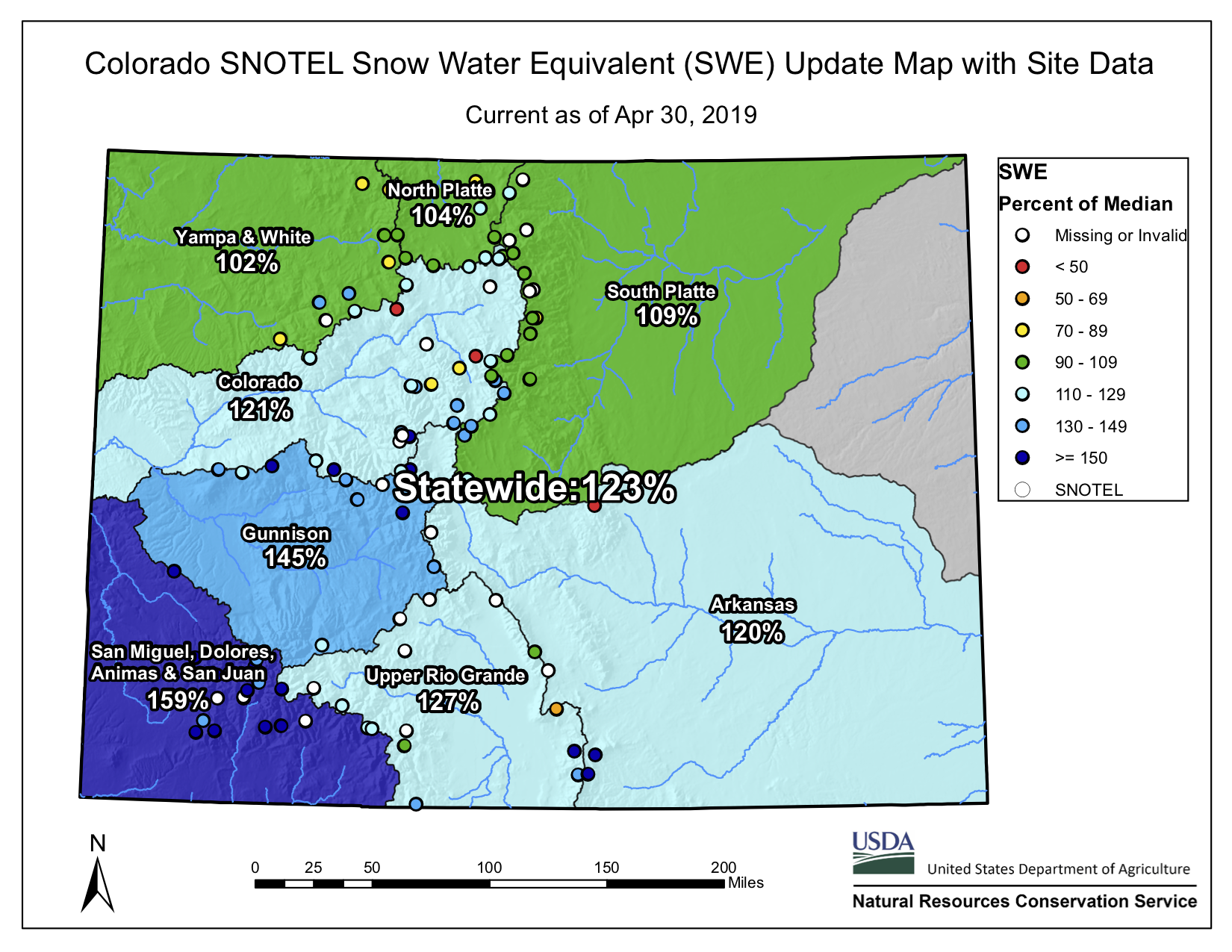
Statewide snowpack basin-filled map April 30, 2019 via the NRCS. FromThe Vail Daily (Scott Miller):
The Eagle River Water & Sanitation District looks at three key areas to measure snowpack: Vail Mountain, Copper Mountain and Fremont Pass. The latter two sites are the nearest measurement sites to the headwaters of Gore Creek and the Eagle River, respectively.
The snowpack, as measured in “snow water equivalent” at Copper Mountain and Fremont Pass are both very good — more than 130 percent of the 30-year median.
Different at Vail
Vail Mountain is a different story. There, the snowpack peaked March 25 — 30 days earlier than the normal peak. It plateaued for a couple of weeks, then started to decline April 14.
Despite a very good snow season, Vail Mountain’s peak was only 92 percent of the 30-year median. As of April 25, Vail Mountain’s snowpack was 78 percent of normal. The warm weather in Vail dropped the snowpack even farther in a matter of days.
Vail’s snow water equivalent peaked at 20.8 inches — again, this is the amount of water in the snow — and sat at 17.6 inches April 25. But there was another one-inch drop from April 26 to April 26, and the measurement site showed a four-inch decline over just 10 days.
The measurement sites at Copper and Fremont had better news. At Copper, snowpack peaked April 14 — two weeks sooner than normal. But the peak was 132 percent of the 30-year median.
As of April 25, the snowpack at Fremont Pass hadn’t yet begun to decline, and was at 135 percent of the 30-year median.
While this water season is setting up to be a good one — depending on a combination of temperatures, speed of the runoff and the arrival of summer rains — Diane Johnson of the Eagle River Water & Sanitation District noted that one good season doesn’t make up for nearly two decades in some sort of drought.
The current cycle has lasted long enough that some climate watchers have stopped using “drought” and are now calling this the “aridification” of the mountain west.
What that means, Johnson said, is that water system customers need to think about water use in new ways.
“People need to change their habits,” Johnson said, particularly regarding landscaping and irrigation. While most water used indoors eventually returns to local streams, most irrigation water soaks into the soil and doesn’t return to streams.
As local streams reached critically low levels in 2018, the Eagle River Water & Sanitation District issued hundreds of letters to people who were using far more water than they should, almost of all of which went to landscape watering.
Johnson said the district issued on “a couple” of substantial fines, adding that most customers voluntarily complied with orders to use less water.
But using less water needs to become the rule, not the exception, Johnson said.
“There are ways to be efficient and still have beautiful landscapes,” Johnson said. “It means being much more thoughtful in what you plant and how it’s designed. There are all sorts of beautiful, cool things that can be done.”
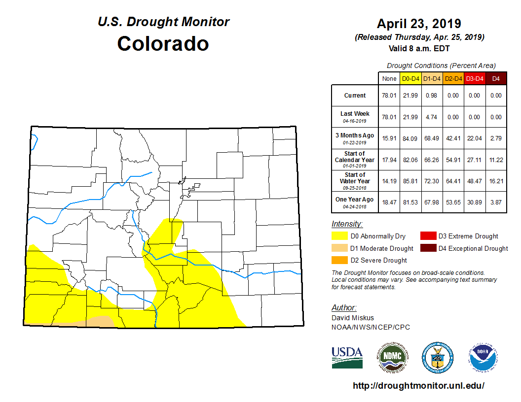
The drought that parched crops, crunched ranchers and drained reservoirs across Colorado in 2018 has quietly come to an end, a new map from the U.S. Drought Monitor shows.
Just 1 percent of the state is still in drought, compared to more than 50 percent earlier this spring.
“This is the best year that you could have after what we had last year,” said Colorado assistant state climatologist Becky Bolinger.
Colorado Drought Monitor April 23, 2019.
Massive February snowstorms and a March bomb cyclone helped bring the statewide snowpack to 122 percent of average. In southwestern Colorado, conditions are so wet that some farmers can’t get to their fields to plant crops.
“It is crazy from before,” said Montezuma County hay producer Brian Wilson with a chuckle. He estimated he’s about two weeks behind schedule.
As Wilson waits for conditions to dry out, he’s purchased more fertilizer and supplies. He expects to grow more hay this than in 2018. But he also worries because he’s spent more money than usual.
“There’s always a gamble, yes,” Wilson said. “We’re hoping to at least break — even make a little bit — to recoup some of the losses we’ve had.”
Wilson and other farmers depend on water from nearby McPhee Reservoir in southwestern Colorado. In early February it was 7 percent full. Now it’s a quarter full and expected to fill up all the way.
“[February and March] just came on like gangbusters,” said Mike Preston, general manager at Dolores Water Conservancy District. “The probabilities are that we’ll fill the reservoir, and we’ll have some excess water.
For Preston, that means letting extra water run down the river for boaters and recreators. That water will travel into the Colorado River system and help fill Lake Powell, a key part of the Colorado River Basin storage system…
This year won’t be easy for farmers, either: Some face declining crop prices while others struggle to find workers to harvest crops. And of course, there’s no telling when another dry year like 2018 might come along. The expectation is that it will get worse as the climate warms.
“What we do know is that if it’s hotter, there will be more evaporation, less recharge and less runoff,” said Reagan Waskom, director of the Colorado Water Institute at Colorado State University. Waskom said CSU is making great strides in developing seeds and technologies that may help farmers in the future. Colorado will likely see more swings like what happened over the past year, and new research won’t get rid of that white-knuckle emotional rollercoaster for farmers.
“So we may have drier drys and wetter wets and hotter hots,” he said. “We’ll figure out how to deal with climate. But it’s those weather extremes — drought, flood, hail — that are really hard to cope with.”</blockquote<
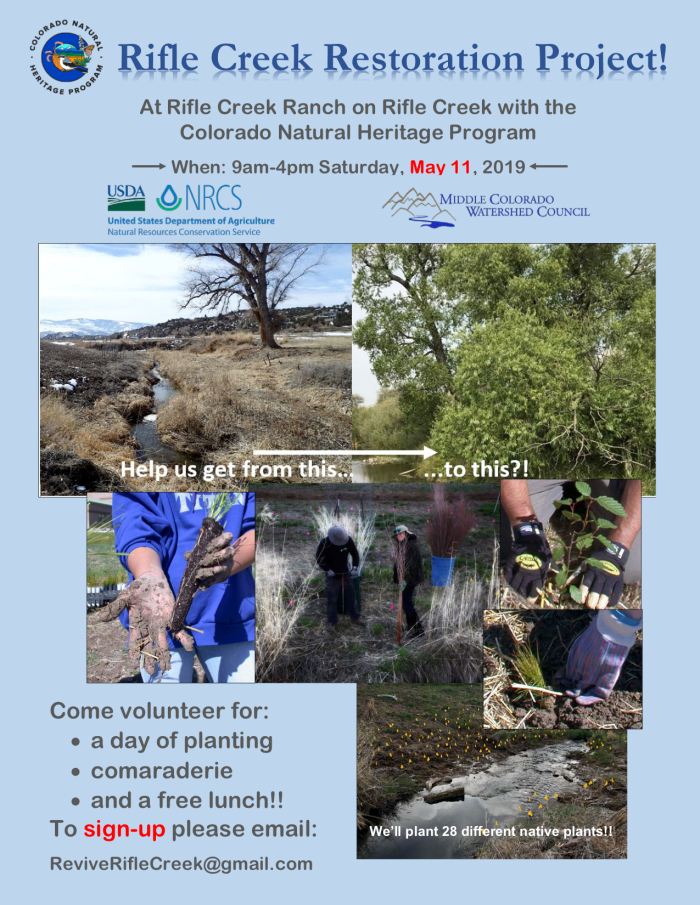
The Middle Colorado Watershed Council is partnering with the Colorado Natural Heritage Program and NRCS to plant native vegetation along the banks of Rifle Creek. This is an effort that will improve water quality, benefit fish and wildlife, and restore ecosystem function. We have already planted over 800 willow and cottonwood cuttings! We will continue this effort by planting a wide variety of different native rooted plants that will hopefully get this stretch of Rifle Creek back towards what it should be.
This event includes lunch, snacks, and camaraderie! It will be 9am to 4pm, come for all or part of the day!
To sign up send an email to ReviveRifleCreek@gmail.com. Also, you can give an RSVP on Facebook.
The goal is for local community members, students, master gardeners’, natural resource buffs, local landowners, and anyone interested to involved and then be able follow the results of the these efforts for years to come. So come help us get 1,400 native plants in the ground on May 11th! Well… and there is always that free lunch!
Persistent moisture and near normal temperatures throughout March resulted in significant drought improvements across the region. While April has seen warmer temperatures and decreased precipitation, water year to date precipitation remains above average statewide. This is helping to reduce the threat of large wildfires. We will continue to monitor throughout the snow melt season to determine inflows to reservoirs, streamflow levels. Post wildfire flooding remains a concern and will be closely monitored. The daily flood threat bulletin can be accessed May 1 through September 30 HERE.
Colorado Drought Monitor April 23, 2019.
As of April 23, a mere one percent of the state remains in moderate drought and an additional 22 percent is abnormally dry. This represents a 71 percent reduction in D1-D4 conditions since the start of the water year.
El Niño conditions are now present, and a weak event is likely to continue through summer (65 percent chance) and possibly fall (50-55 percent chance) of this year. Historically spring & summer during an El Niño are more likely to be wet than dry, and the NOAA Climate Prediction Center outlooks for May, and for the May-June-July period show increased chances of wetter-than-average conditions.
SNOTEL snow water equivalent statewide is 120 percent of median with all basins near or above normal. The highest snowpack is in the Southwest basins of the San Miguel, Dolores, Animas & San Juan at 157 percent of median, while the lowest is the Yampa-White at 100 percent of median.
Statewide reservoir storage as of April 1, is 84 percent of normal but is expected to increase as the runoff season begins. The South Platte, Arkansas, Colorado, and Yampa-White, are all above 90 percent of average, while the Upper Rio Grande basin has 79 percent of normal storage. The Southwest basins of the San Miguel, Dolores, Animas & San Juan, and Gunnison remain the lowest in the state at 58 and 67 percent of normal, respectively.
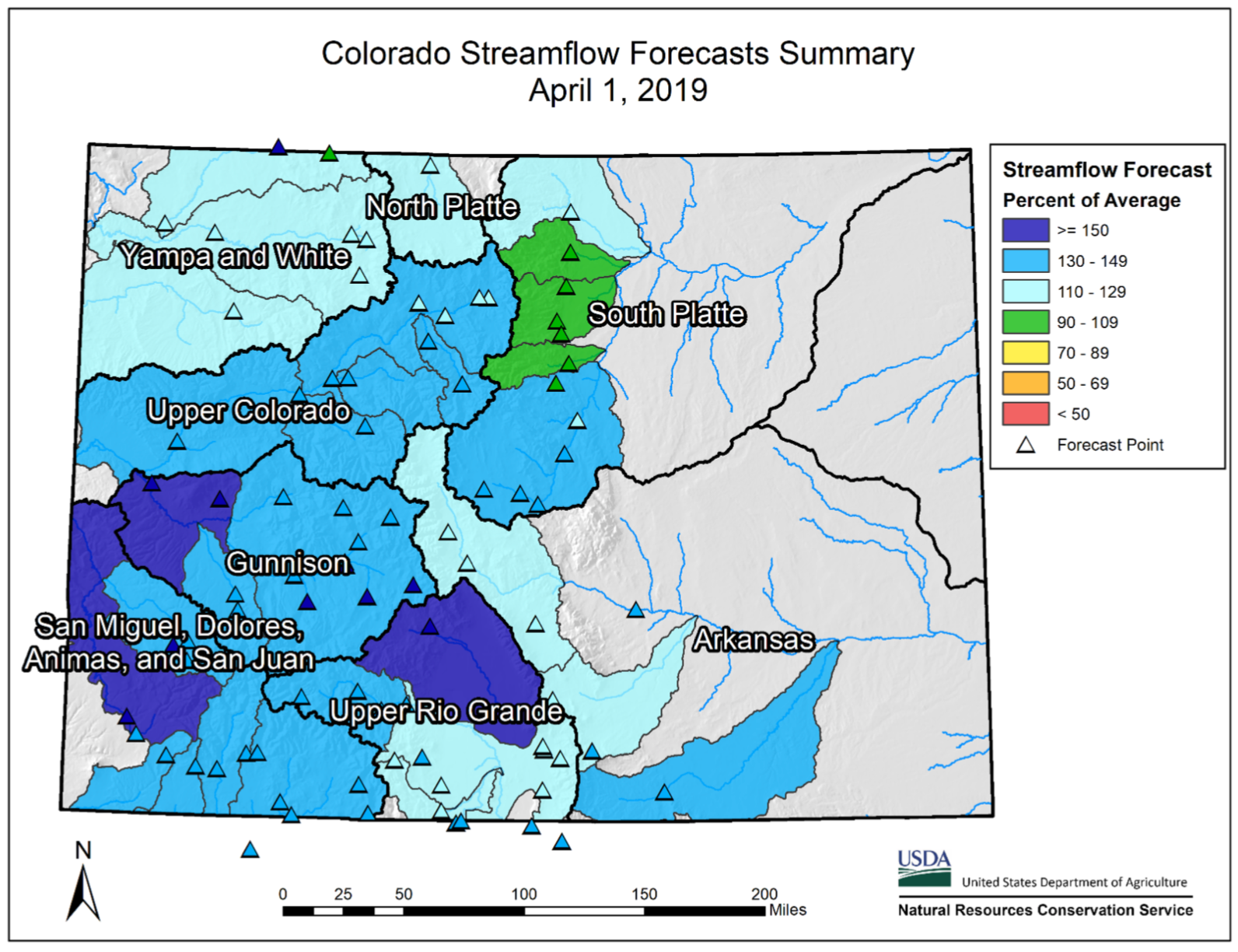
Streamflow forecasts are near to above normal statewide. Snowpack in the southwestern corner of the state is driving streamflow forecasts greater than 150 percent of average in the Dolores, Surface Creek and Saguache-San Luis Basins. Above average streamflows can help to replenish reservoir storage in these regions of the state.
The surface water supply index (SWSI) has improved in recent months with the majority of the state trending to the wetter conditions, this is in part due to strong streamflow forecasts.
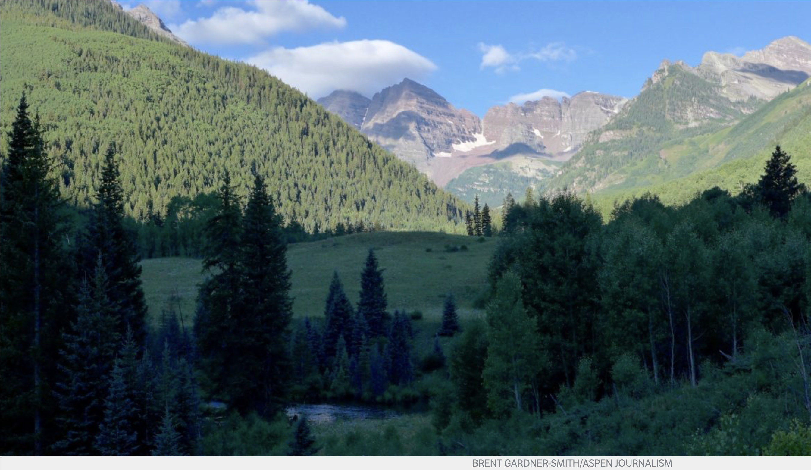
The City of Aspen holds conditional water rights tied to a potential 155-foot-tall dam that would flood a scenic meadow with dramatic views of the Maroon Bells. The city is seeking a diligence ruling on those rights, which it then intends to transfer to other locations. Photo credit: Brent Gardner-Smith/Aspen Journalism
The question of whether the City of Aspen has valid conditional water-storage rights tied to the potential Castle and Maroon creek reservoirs — rights the city now wishes to move to other locations — remains unresolved before state water court.
The latest activity in the two water-court cases about the Castle and Maroon water rights took place April 19, when water attorneys for the city responded to a judge’s request to provide more information about two key legal questions: whether the city has been diligent in its efforts to develop the reservoirs and whether it has a legitimate need for the amount of water it is claiming.
It’s not yet clear whether the information the city submitted to the court April 19 will be enough to satisfy Judge James Boyd, who is overseeing both cases — one involving the Castle Creek Reservoir water right and the other involving the Maroon Creek Reservoir water right — in Division 5 water court in Glenwood Springs.
A case-management conference call in the case was slated for Thursday morning — and that may have provided some insight into how the judge viewed the city’s latest information — but another ongoing trial required the judge to reschedule the conference call about the Castle and Maroon water rights for May 8.
Boyd in November told the city’s water attorney, Cynthia Covell of Alperstein and Covell, that he needed more information on both diligence and need.
“I don’t know if I have any information, really, in the record for me to make the finding that as part of a diligence decree, or diligence burden of proof, of a substantial probability that the project will ultimately reach fruition, so it seems to me I may need some additional actual record to support that conclusion,” Boyd said in November.
Regarding the city’s stated need for up to 13,000 acre-feet of water between the two potential reservoirs, he also said, “There is nothing in the record to really explain why that’s an appropriate number for the court to approve, and I think I may need some record to support that.”
The city is seeking a ruling from the judge that it has been diligent in developing the two potential reservoirs.
The city has told the court that, after obtaining a positive diligence finding, it intends to try to transfer the location of the conditional water-storage rights, which carry a 1971 adjudication date and 1965 appropriation date, from the original locations in upper Castle and Maroon creeks to locations closer to the Roaring Fork River.
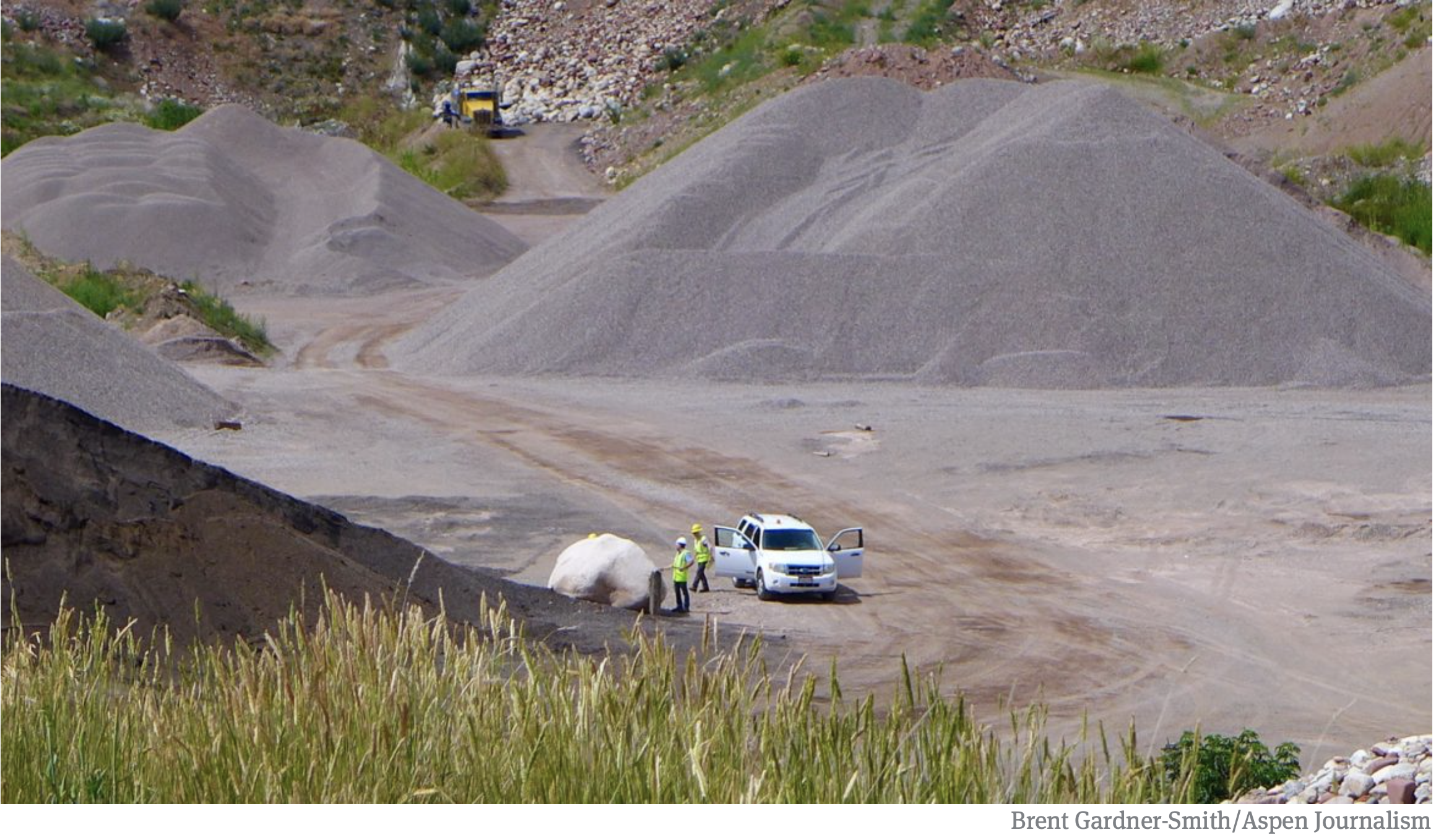
The locations include the city’s golf course, the Maroon Creek Club golf course, the Cozy Point open space, the Woody Creek gravel pit operated by Elam Construction and an empty parcel of land next to the gravel pit now owned by the city.
A look into the deep hole in Woody Creek at the gravel pit operated by Elam Construction. The City of Aspen has included this location on its list of potential locations it might move the water rights from the Castle and Maroon creek reservoirs to, along with an undisturbed parcel next door to the gravel pit. Photo credit: Brent Gardner-Smith/Aspen Journalism
Briefly
In the information submitted to the court April 19, in both cases, Covell made the city’s case in succinct fashion, submitting a six-page, revised proposed decree and a four-page supplement to an earlier motion to approve the proposed decree.
The city has previously told the court that it has been diligent in its efforts to develop the reservoirs and that it does, in fact, need the water to meet future demands, especially given climate change.
And it said so again April 19 — but without adding much, if any, new information to the existing court record.
“Aspen needs the Maroon Creek Reservoir water right,” the city said in the April 19 filing. The city also told the court that it “has exercised reasonable diligence in the development of the Maroon Creek Reservoir water right.”
It made similar statements regarding the water right tied to a potential Castle Creek Reservoir.
Under Colorado water law, decisions about whether an applicant has been reasonably diligent in pursuing the development of a given water project are made by a judge on a case-by-case basis.
The court cases began when the city filed a diligence application with the water court in October 2016 seeking to maintain its conditional water-storage rights for both reservoirs, which the city first filed for in 1965.
Ten parties — Pitkin County, the U.S. Forest Service, American Rivers, Wilderness Workshop, Colorado Trout Unlimited, Western Resource Advocates and four private property owners — filed statements of opposition in response to the city’s 2016 diligence applications.
Two years later, in October 2018, the city announced it had reached agreements with all of the opposing parties in the two cases and submitted those agreements to the court, along with a request that the court issue a new decree finding that the city has been diligent and that the conditional water-storage rights are valid for at least another six years.
The new decree also incorporates the terms of the agreements reached with the opposing parties.
The agreements say the city will not build the Maroon and Castle creek reservoirs in their decreed locations and, instead, will seek to move the location of the conditional water storage rights out of the two pristine valleys.
The city also is now limited to storing no more than 8,500 acre-feet of water in the new locations, instead of potentially storing more than 13,000 acre-feet under the original decrees. The water for the 8,500 acre-feet of storage could come from both Castle and Maroon creeks under the agreements.
Today, the city’s water supply comes primarily from Castle Creek, but the supply is supplemented with water from Maroon Creek. The city has senior water rights for those diversions that are not tied to the conditional water storage rights.
The opposing parties also agreed not to challenge the city’s anticipated request to change the location of the conditional storage rights, but other outside parties may still do so.
Notably, in the latest information submitted by the city, there is a sentence in each case that seems to contradict the city’s agreed-upon position that it no longer intends to build either the Castle or Maroon creek reservoirs.
A sentence in the supplement to an earlier motion in the Maroon Creek case says, “Aspen intends to construct the Maroon Creek Reservoir to provide a legal, reliable water supply to its customers.”
In the Castle Creek case, a similar sentence says, “Aspen intends to construct the Castle Creek Reservoir … .”
Asked about the sentence in the Maroon Creek Reservoir case, which seems at face value to indicate that Aspen still intends to build a big dam within view of the iconic Maroon Bells, Covell said, “They intend to construct the reservoir. They intend to construct it at a different location.”
Aspen Journalism covers rivers and water in collaboration with The Aspen Times and other Swift Communication newspapers. The Aspen Times published this story on Friday, April 26, 2019.
“The city is confident, based upon volumes of analysis, that it has adequate water supply to provide West Steamboat Neighborhoods, even in dry years,” city Water Resources Manager Kelly Romero-Heaney said…
According to a water demand study conducted by the developers, at full build-out, homes in the neighborhood will require a total of 203.9 acre-feet of additional water…
The addition of a school and commercial developments increase this demand to 255.3 acre-feet, Romero-Heaney said…
Between 2006 and 2017, the city of Steamboat Springs used an average of 1,344 acre-feet each year, according to Romero-Heaney.
In 2012, one of the driest years on record in the Yampa River Basin, according to the Natural Resource Conservation Service, about 7,800 acre-feet of water was available to the city from Fish Creek, Romero-Heaney said. The Yampa River added another 2,000 acre-feet.
She estimated that 93% of the water the city uses comes from Fish Creek, with the remaining 7% coming from the Yampa River. The city is working to expand its Yampa River water intake to provide an additional water source should Fish Creek become unusable.
Funding additional water infrastructure
Before the first home is built, West Steamboat Neighborhoods will be required to do the following under the annexation agreement:
Pay $292,000 to a newly established water-firming fund to pay for additional water infrastructure
Install a “water distribution system” either by extending a water main along U.S. Highway 40 that currently ends near Snow Bowl Plaza, by connecting to and extending from water lines in the neighboring Overlook Park development or by building a storage tank in the development
Install pressure-relief valves and boosters
Brynn Grey will be required to pay $15,000 to the water-firming fund upon the closing of each market-rate home. There will be an additional $11,200 payment to the fund on closing when selling homes with secondary units. This amount will be adjusted for inflation according to the Engineering News-Record Construction Cost Index.
This payment is in addition to standard tap fees Brynn Grey will pay when it receives a building permit for each home. Water tap fees equate to about $6,800 for a 1,500-square-foot, two-bath, single-family home.
The developer’s total contribution to the water-firming fund is expected to be more than $4.67 million at full build-out, according to the city.
The water-firming fund would be used to eventually build an additional water-treatment plant and purchase additional water rights, which would be necessary should the city annex land beyond West Steamboat Neighborhoods, Romero-Heaney said.
The city also will build a new water tank on the west side of town within two years of the proposed annexation agreement taking effect. In 2018, the city budgeted $3.82 million for the project.