


Well now, snowpack in the Upper Colorado River basin below 60% of average is concerning. Luckily, reservoir storage is in good shape in most areas including the South Platte River basin. Front Range cities in the basin move several hundred thousand acre-feet of water per year from the Colorado River. Colorado Springs and Pueblo get at least some of their supply from the Colorado River as well.
Direct irrigators can be significantly harmed in a water short year and those reservoirs which are in good shape right now may not refill during the runoff season, setting things behind for water year 2013.
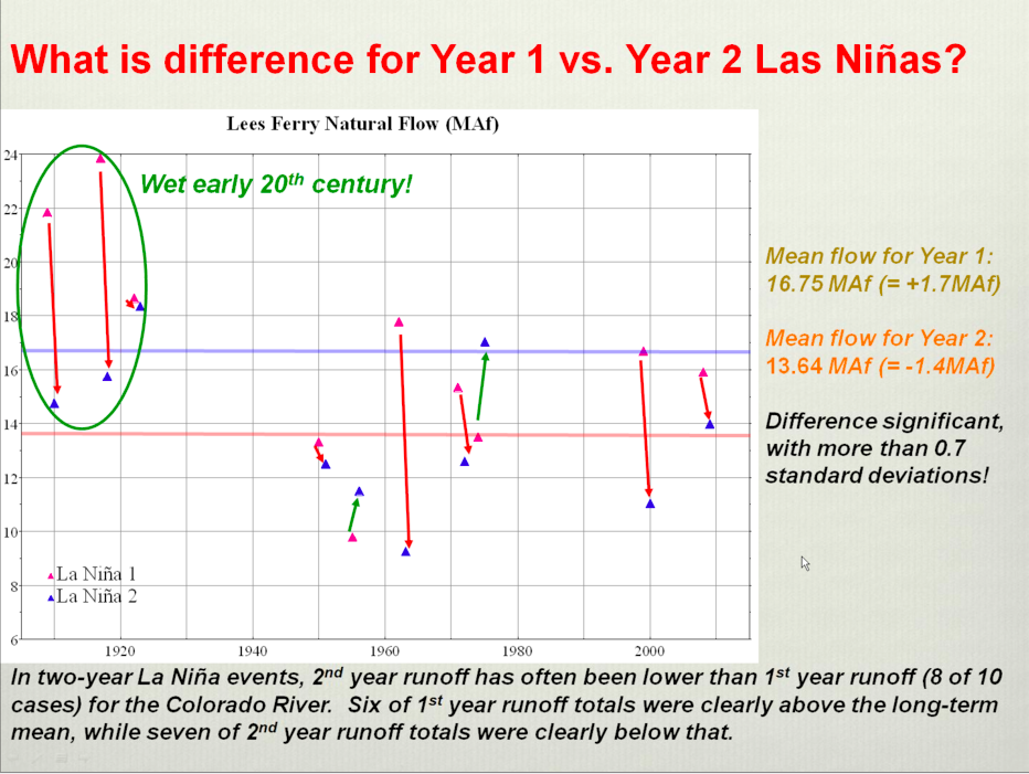
I like to link to this graphic from Klaus Wolter and the Climate Prediction Center that shows reduced flows at Lees Ferry in second-year La Niña events. We’re are in the midst of a second-year La Niña event.
Click on the thumbnail graphics above and to the right for the current snowpack map for Colorado and the precipitation summary from this week’s NIDIS Weekly Climate, Water and Drought Assessment Summary of the Upper Colorado River Basin from the Colorado Climate Center.
From the Summit County Citizens Voice (Bob Berwyn):
“A lot can happen between now and spring,” said Bob Steger, manager of raw water supplies for Denver Water. Reservoir storage is above average and above last year’s, with the Denver Water system at 90 percent of capacity, compared to the average 83 percent for this time of year, Steger said.
And that’s a good thing, because the statewide snowpack is only at [67] percent of average, with the key Colorado River Basin (encompassing Summit County) only at [58] percent of average.
That’s the fourth-lowest level in the past 30 years, according to Mage Skordahl, assistant snow survey supervisor with the Natural Resource Conservation Service. The only years with lower snowpacks at this point in the season during that 30-year span were 1990, 2000 and 2002, she said.
“When you start out like this, it’s not too often that you end up above average … We’d need to have above average snowfall the rest of the season just to get back to average,” she added.
While officials still seem sanguine at this point, Scott Hummer, the former Blue River Basin water commissioner for the State Engineer’s Office, said that, if he were still wearing that hat, he’d be starting to get concerned about long-term water supplies if the current weather trend continues.
Troy Wineland, the new Blue River Water Commissioner, said he’s definitely scratching his head about the upcoming irrigation season, but hoping that a predicted return to a snowy La Niña pattern could help boost the snowpack back toward average.
From The Mountain Mail (Ericka Kastner):
[Jennifer Stark, head meteorologist with the National Weather Service in Pueblo] said this week a ridge of high pressure in the atmosphere has been building over the Colorado Rockies and it brought in “quite a bit of warm weather…
Last winter there was a lot of snow in the west and north central United States, and in the mountains of Colorado, Stark said. “This year it is kind of reversed … the plains and southeast portion of the state have had more snow than this time last year.”
So, how about La Niña. Here’s the link to the latest ENSO diagnostic discussion from the Climate Prediction Center. Here’s the synopsis:
Synopsis: La Niña is expected to continue into the Northern spring 2012.
During December 2011, below-average sea surface temperatures (SST) associated with La Niña continued across the eastern and central equatorial Pacific Ocean. The weekly SST index in the Niño-3.4 region remained near –1.0°C throughout the month, indicating a weak to moderate La Niña. The oceanic heat content (average temperature in the upper 300m of the ocean) anomalies strengthened across the eastern Pacific, reflecting a large area of below-average temperatures in the subsurface. In the atmosphere, anomalous low-level easterly and upper-level westerly winds strengthened over the central and west-central Pacific. Convection remained suppressed in the western and central Pacific and enhanced over northern Australia and parts of Indonesia and the Philippine Islands (Fig. 5). Consistent with these conditions, the Southern Oscillation Index (SOI) also strengthened. This evolution is consistent with past events, in which the atmospheric components of La Niña become strongest and most well-defined during the Northern Hemisphere winter. Collectively, the ongoing oceanic and atmospheric patterns reflect the continuation of a weak to moderate La Niña.
A majority of models predict a weak or moderate strength La Niña to peak during the December – February season, and then to continue into early Northern Hemisphere spring season before dissipating during the March to May period. A slight majority of models predict La Niña to remain weak (3- month average SST anomaly in the Niño-3.4 region between -0.5 and -0.9°C) this winter, while several others predict a moderate-strength episode (anomaly in the Niño-3.4 region between -1.0 and -1.4°C). The latest observations, combined with model forecasts, suggest that La Niña will be of weak-to- moderate strength this winter, and will continue thereafter as a weak event until it likely dissipates sometime between March and May.
During January – March 2012, there is an increased chance of above-average temperatures across the south-central and southeastern U.S., and below-average temperatures over the western and the northwest-central U.S. Also, above-average precipitation is favored across most of the northern tier of states and in the Ohio and Tennessee Valleys, and drier-than-average conditions are more likely across the southern tier of the U.S. (see 3-month seasonal outlook released on 15 December 2011).

