
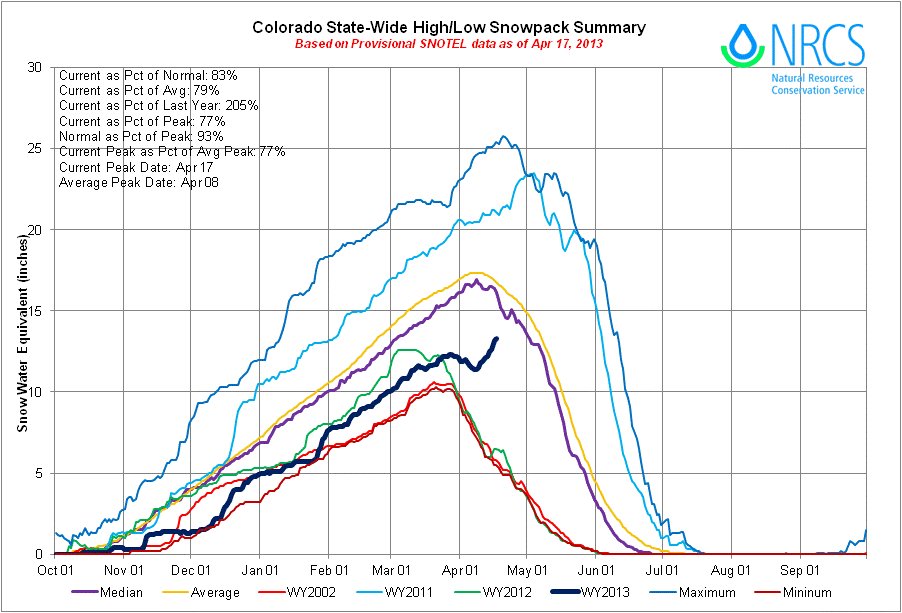
Click on the thumbnail graphics for the statewide snowpack map along with the statewide Basin High/Low graph for yesterday. It’s been a long time since there was any green (average) on the statewide snowpack map. Back on February 12, 2013 the combined San Juan, Animas, Dolores and San Miguel snowpack showed up green, narrowly, at 91% of average. Yesterday, the Upper Colorado River and the North Platte River basins turned green due to the recent snowfall. Keep in mind that the Upper Colorado River Basin is often melting out by now so it is gaining against a declining average. In any case it increased 2-3 inches of SWE this month so far and that is good news.
From The Pueblo Chieftain (Chris Woodka):
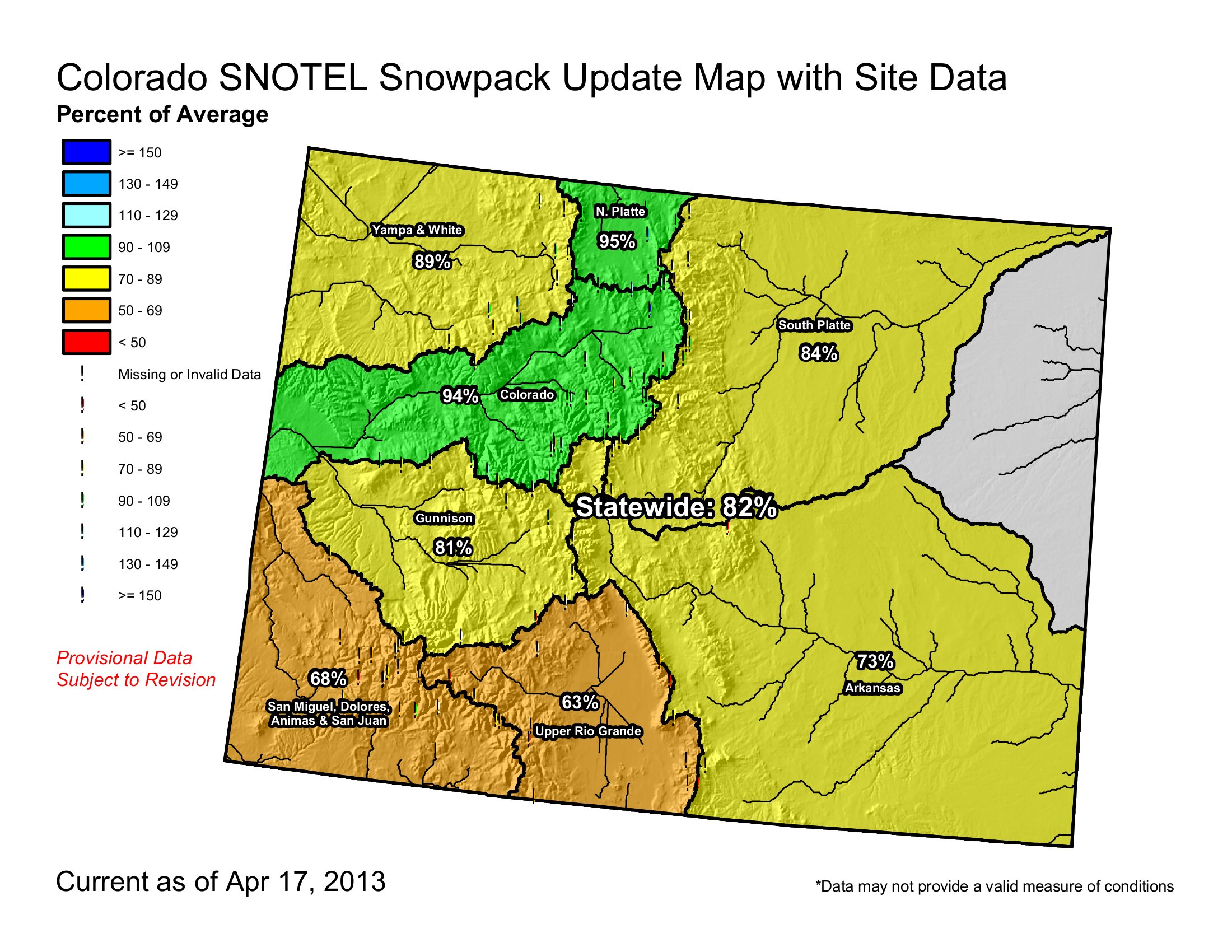
… a steadily increasing snowpack…is approaching nearly normal levels at a few sites in the mountains. Statewide, snowpack was about 82 percent of normal Wednesday, 73 percent in the Arkansas River basin, but 94 percent in the Upper Colorado basin, which provides supplemental water to Arkansas River users. However, snowpack in the Purgatoire River basin, which helps farmers below John Martin Dam, is far below average.
Reservoir levels are well below 2012, and at 2003 levels for Turquoise and Twin Lakes. Lake Pueblo is at 88 percent of normal, better than it was in 2003, after drought had tapped out water supplies.
From the Loveland Reporter-Herald (Tom Hacker):
Five straight days of stormy mountain weather have pushed a once-dismal snowpack much closer to normal. High mountain snows that feed the Big Thompson and Poudre rivers were at 70 percent of normal levels April 8, but on Wednesday they had reached 86 percent of the average for the date. It’s a big jump, and at just the right time. “The good news is that this comes when we’re not watering and we’re not irrigating,” said Mage Skordahl, snow survey supervisor for the Natural Resources Conservation Service in Denver…
Just a week ago, municipal water providers and farmers heard gloomy predictions for the summer ahead from Northern Water, the agency that manages the water supply from the Colorado Big-Thompson Project. And board members of the agency on Friday said Northern Water would distribute just 60 percent of the annual water shares to users. That was before the snow began falling. The forecast for the northern Front Range calls for more mountain snow in the week ahead. “This is a good month, no question about it,” Northern Water spokesman Brian Werner said Wednesday. “It plays hell with my golf game, but I’m willing to forgo golf if it means we’ll have more water.”[…]
…a [SNOTEL site snow] pillow that transmits data from Bear Lake in Rocky Mountain National Park on April 1 counted 10.3 inches of “snow water equivalent” — the conservation service’s most-watched measure. On Wednesday, it hit 14 inches, moving toward the 30-year median April peak of 18.6 inches. “From the point of view of the municipalities, we’re still below normal,” Skordahl said. “We depleted our reservoir storage so much last year that there’s still some concern. But if this keeps up, there’s a chance we could reach our normal peak. It’s great news that these storms have finally arrived.”