
Click on the thumbnail graphic to view the precipitation summary from the Colorado Climate Center. Click here to view all the summaries.

Click on the thumbnail graphic to view the precipitation summary from the Colorado Climate Center. Click here to view all the summaries.
Here’s the release from the Natural Resources Conservation Service (Mage Hultstrand):
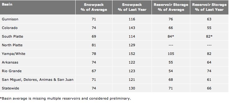
Snowfall in March produced a nominal increase in the statewide snowpack percentage, according to Phyllis Ann Philipps, State Conservationist with the Natural Resources Conservation Service (NRCS). The latest snow surveys confirm that statewide snowpack has increased slightly from 73 percent of median on March 1 to 74 percent on April 1. This is the third consecutive month that the snowpack has increased by just 1 percentage point. Most major basins saw slight improvements to snowpack percentages during March. While the state snowpack remains well below normal, the good news is that most basins continue to accumulate snow and have yet to reach their peaks for the year.
The exception is in the southwest portion of the state which saw significant decreases in snowpack percentages this month. The Gunnison, Upper Rio Grande and the combined San Miguel, Animas, Dolores, and San Juan basins had declines of 3, 11 and 12 percentage points respectively. In these basins it is likely that they have already reached their peak snowpack for this year and are headed into the melt phase.
In the Yampa and White River basins, the snowpack increased from 75 percent of median last month to 78 percent as of April 1. The Colorado River basin’s snowpack increased from 70 percent to 74 percent of the median. The South Platte and North Platte River basins’ snowpack’s both increased by 6 percentage points and the Arkansas River basin had an increase of 3 percentage points.
In a typical winter the state receives around 20 percent of its seasonal snow accumulation during March. This winter however, March precipitation recorded at SNOTEL sites was well below normal with the exception of the South Platte and Colorado River basins. With April 8, the average date the snowpack reaches its peak in this state, less than a week away; there is almost no chance that the snowpack will reach normal conditions before beginning to melt.
Reservoir storage remains well below average statewide and all major basins in Colorado are expected to see below average streamflow runoff this spring and summer.
Click on the thumbnail graphic above to view the NRCS’s table for snowpack and reservoir storage.
Sunny, but chance of rain Wednesday in Morgan County: Morgan County will see a slight chance of rain and s… bit.ly/107JuOh #fb
— Fort Morgan Times (@FortMorganTimes) April 3, 2013
A ridge of high pressure will begin to build in today, bringing warmer and drier conditions, although a few shower twitpic.com/cgmdj3
— NWS Grand Junction (@NWSGJT) April 3, 2013
From the National Weather Service Grand Junction office:
A ridge of high pressure will begin to build in today, bringing warmer and drier conditions, although a few showers will remain possible over the mountains, mainly near the Continental Divide. Further warming will occur on Thursday as the ridge passes overhead. A series of disturbances in westerly flow will cause unsettled conditions Friday through early next week. Periods of showers including mountain snow are anticipated along with a gradual downturn in temperatures.

From The Pueblo Chieftain (Chris Woodka):
Odd as it might sound, Pueblo city parks will be using less water this year in an effort to improve the turf. “We realize we may get a few complaints that the parks aren’t green enough during the first year,” said Brad Bixler, interim parks manager. “But there are benefits to a reduced watering schedule.”
The city plans to reduce water consumption by 30 percent to 40 percent from previous years through deeper, less frequent watering. Watering more deeply less often encourages roots of all plants, including trees, to grow deeper in search of water and will make turf more drought-tolerant in the future, Bixler said. Because seasonal parks staff has been reduced, it also will allow less frequent mowing and maintenance in the park because of slower turf growth.
By eliminating wet conditions in the parks, it will reduce the threat of Japanese beetles, which damage shrubs and trees. “Drying out turf between watering days is one method to help interrupt the life cycle of the Japanese beetle,” Bixler said.
Pioneer and Mountain View cemeteries also have agreed to voluntarily reduce watering days to four times weekly from five times weekly, he said.
The city of Pueblo waters parks in the evenings because people are using the parks in the daylight hours. Watering during the cooler times of day increases effectiveness of irrigation by reducing evaporation. The one drawback will be the increased likelihood of weeds, which the city will manage with an earlier fertilization and weedcontrol schedule, Bixler said.
The Pueblo Board of Water Works provides nocharge or half-price water for public landscaping to the city, county, schools and state. Last year, with less than 5 inches of precipitation, public watering increased by nearly 8 percent, while paid metered consumption increased just 5 percent, according to a water board report. Bixler said the city’s watering changes were being considered before that report was made public.
From The Pueblo Chieftain (Chris Woodka):
Lake Minnequa will continue to shrink if the drought persists, even though a pipeline to bring fresh water into the lake is expected to be completed in June. “The Pueblo Board of Water Works agreed to replace the evaporation when the lake is full, but there was no anticipation of having to fill the lake,” said Terry Book, executive director of the Pueblo water board. “It’s a natural lake.”
Under an agreement among the water board, the city of Pueblo and the Lower Arkansas Valley Water Conservancy District, the water board would commit up to 450 acrefeet annually to replace evaporation. The surface area of the lake is 164 acres, when full. But one clause in the agreement gives the water board authority to make restrictions on delivery of water during times of shortage.
Pueblo is now in its third year of drought, and unless a gullywasher occurs sometime soon, there is little likelihood of the lake filling. The Lower Ark also agreed to run up to 250 acre-feet of its water through Lake Minnequa, but again, that requires a nearly full lake. Right now, the water level is several feet below the discharge outlet to the Arkansas River. “The obligations kick in when levels are outside the natural lake levels,” Book said.
The board and city are completing a 3.7-mile, $1 million gravity-flow pipeline from the Evraz Rocky Mountain Steel reservoirs at Stem Beach to Lake Minnequa. The city is repaying the water board for the construction work.
The only source of water in the lake is stormwater flows from the city’s South Side. Meanwhile, city stormwater crews are working on a portion of Lake Minnequa on the north shore to create deeper pools for fish. Fish die-offs and odor problems have persisted for the last two summers as water levels declined. In late December, there was a brush fire at the lake.
The city began to redevelop the Lake Minnequa area as a park in 2004, and last year completed football fields on the south end. The park also includes a playground, basketball courts and a trail which surrounds the lake.

Meanwhile, down in New Mexico, where surface water forecasts for the season are dire, Pecos River diverters are taking action to shut down groundwater pumpers. Here’s a report from John Fleck writing for the Albuquerque Journal. Here’s an excerpt:
The leaders of the Carlsbad Irrigation District voted this afternoon to demand the state of New Mexico shut off groundwater users upstream in the Roswell and Artesia areas to protect Carlsbad-area farmers’ right to Pecos River water. With the third year of deep drought hovering over New Mexico, the unanimous vote by the irrigation district’s five-member board marks the most serious confrontation this year between New Mexico water users scrapping over increasingly scarce supply. At its worst, the “priority call” could force a large number of groundwater users in the Roswell and Artesia area, including farms, cities and industry to shut down their the pumps that supply their groundwater.
The board’s vote is the latest and most serious volley in a longstanding water conflict between farmers in the Carlsbad area, who largely depend on water from the Pecos River, and farmers to their north in Roswell and Artesia, who use groundwater. The downstream farmers have long complained that the Roswell-Artesia pumping is slowing draining away water that would otherwise flow in the Pecos to their farms. Carlsbad-area farmer Oscar Vasquez, a member of the board, said that last year was the first time in 37 years of farming that he failed to produce a single bail of cotton on his 400 acres…
Meanwhile upstream, pumps in the Roswell-Artesia part of the Pecos Valley were running full blast this week, creating a contrast between water haves and have nots.
A couple snow totals from the mountains this afternoon/evening. 7″ near Ward, 4″ near Breck, 3″ Estes Park. forecast.weather.gov/product.php?si…#COwx
— NWS Boulder (@NWSBoulder) April 3, 2013
From The Grand Junction Daily Sentinel (Dennis Webb):
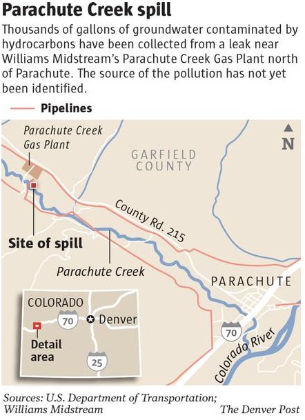
Benzene levels as much as 800 times more than the federal drinking water standard have been found in shallow groundwater in a monitoring well just 10 feet from the banks of Parachute Creek at the site of a liquid hydrocarbon leak. However, Todd Hartman, spokesman for the state Department of Natural Resources, said Tuesday testing of the creek water continues to show no signs of contamination from the leak. Sampling results from the newly completed well shows benzene levels of 1,900 to 4,100 parts per billion. The Environmental Protection Agency’s maximum allowable level for benzene, a carcinogen, in drinking water is 5 ppb.
Readings from three other wells farther from the creek and closer to the contamination site have shown readings ranging from 5,800 ppb to 18,000 ppb. The highest reading is near a recovery trench dug as part of the leak cleanup. That trench, and the area around an above-ground valve set for a 4-inch-diameter natural gas liquids line from Williams’ nearby gas processing plant, are being investigated as possible sources of what investigators think may have been historic releases of hydrocarbons. No active leak sources have yet been found. Williams spokeswoman Donna Gray said Tuesday the 4-inch line went into service in 2008.
The contamination was discovered by Williams in a pipeline corridor March 8 as it was doing location work. Some 6,000 gallons of hydrocarbons were recovered.
Hartman said the new monitoring well is about 325 feet southeast of the valve set and recovery trench. Investigators for the Colorado Oil and Gas Conservation Commission believe groundwater is flowing from the creek toward the contamination site, rather than vice versa, which is helping protect the creek from contamination. “More work to delineate the extent of groundwater impacts continues and surface water sampling in Parachute Creek immediately adjacent to this specific monitoring well is planned for (today),” Hartman said in a daily e-mail briefing to reporters.
Parachute Creek provides irrigation water to the town of Parachute. Town Administrator Bob Knight said Tuesday the town usually releases water from the creek into its irrigation reservoir on April 15. “We are hoping this matter is resolved long before that. But I have no intention of turning water into the reservoir until it is cleaned up and the leak has been found or whatever is causing that,” he said.
He said some residents probably will use the town’s domestic water system for irrigation, which will put more strain on the system’s treatment plant. “But we believe we can handle it for the interim,” he said.

From the Colorado Springs Business Journal (John Hazlehurst):
When Philip Anschutz acquired The Broadmoor in 2011, he also acquired other significant assets owned by Oklahoma Publishing Co., including adjudicated water rights to non-tributary water beneath 7,640 acres of the Greenland Ranch in Douglas County, just north of Monument Hill off Interstate 25.
The ranch, one of the largest tracts of undeveloped land between Denver and Colorado Springs, has had a tangled history. First settled 150 years ago, it remained the property of the Higby family until 1980, when it was sold to a partnership that included Treasury Secretary William “Bill” Simon, Oklahoma businessman Ed Gaylord and Colorado Springs developer Bruce Shepard.
The partnership’s development plans fizzled, as did plans to develop the property’s subsurface water resources. In 2000, the entire 21,000-acre ranch was purchased by the Conservation Fund in a complex partnership with Great Outdoors Colorado, Douglas County, Colorado Division of Wildlife, Colorado State Parks, and Denver billionaire John Malone. The property is protected by a conservation easement, which forbids surface development in perpetuity.
But on the portion of Greenland Ranch formerly owned by Gaylord, water rights were severed from surface rights. A confidential memo offering the rights for sale prior to Anschutz’ acquisition describes the process:
“As part of the sale of the Greenland Ranch in 2000, Sun Resources Inc., a subsidiary of The Oklahoma Publishing Company, reserved the right to all non-tributary groundwater beneath 7,640 acres of the Ranch. The water right entitles the owner to withdraw 1 percent of the total amount per year (14,562 acre-feet) for 100 years. The right is decreed as non-tributary and, therefore is not subject to surface water priorities. In addition, (Sun) has completed significant legal work, as well as preliminary engineering, technical and market analysis. These work products and reports will be transferred with the water right. The right has accompanying surface land easements for well field, treatment facilities, and pipeline infrastructure development that will also be conveyed in the sale. As a result, no further legal proceedings are necessary to develop and sell the water.”
The 14,562 acre-feet would be roughly equivalent to 20 percent of Colorado Springs’ current annual needs…
Last fall, Sun Resources, now an Anschutz-owned company charged with developing the water rights, drilled two deep test wells on the Greenland Ranch property to confirm 1995 estimates of available water. One well, tapping the Arapahoe aquifer, was drilled to a depth of 2,040 feet, and flowed at a rate of 650 gallons per minute during a 72-hour test. The other targeted the Denver aquifer at 1,490 feet and flowed at 350 GPM. These results tended to confirm the 1995 estimates, said Sun CEO Gary Pierson. “We’ve completed those test wells,” said Pierson, “and now we’re in some very intense discussions with interested parties.”[…]
Full development of the water rights would be expensive. Dozens of production wells would have to be drilled throughout the property, power delivered to wellheads, and pump stations and pipelines built to transport the water to potential users…
Should communities rely upon non-renewable resources such as Greenland Ranch groundwater? Colorado Springs Utilities executive Gary Bostrom doesn’t think so.
“That depends on how it might integrate into an existing supply mix,” said Bostrom, who heads the CSU water resources department. “We have well fields, but the value (of non-renewables) is as a supplemental source. That may be attractive to some districts.”[…]
Despite being a non-renewable source, Greenland Ranch water may be attractive to potential users. Making a deal with Anschutz is not like making a deal with an ordinary promoter — you know Anschutz can deliver. His ability to fund a $100 million project is not dependent upon commitments from skittish lenders, or upon the solvency of unrelated parties to any deal.
The water is also of high quality, according to a 2009 independent analysis. It’s low in dissolved solids and uncontaminated by industrial pollutants. That quality likely will remain unchanged, since there will be no surface development either on or adjacent to the property…
Greenland Ranch water, decreed as non-tributary, therefore is not subject to surface water priorities, or any restrictions on its use. In its sweeping 1995 decree, the Water Court couldn’t have been more explicit. “19. Appropriation Doctrine Inapplicable. The rights to groundwater determined herein are not subject to and shall not be administered in accordance with the prior appropriation doctrine or any priority of appropriation. C.R.S. 37-92-305 (11).” The Water Court retains jurisdiction over any eventual Greenland water plan and, based on analysis of drilling results, may adjust the annual withdrawal rate. Pierson appears to believe any adjustment will be upward, mentioning a figure of 17,500 acre-feet annually. CSU’s Bostrom cites 10,000 acre-feet as more likely.