Click here to read the current assessment. Click here to go to the NIDIS website hosted by the Colorado Climate Center.

Click here to read the current assessment. Click here to go to the NIDIS website hosted by the Colorado Climate Center.


Click on a thumbnail graphic to view a gallery of snowpack data from the Natural Resources Conservation Service.
From the Vail Daily:
Snow water equivalent
What does 1 inch of water look like in real snow?
“There are lots of rules of thumb people swear by,” said Diane Johnson of the Eagle River Water & Sanitation District. “Mostly you’ll hear 10 inches or 12 inches of snow to 1 inch of snow water equivalent, but it’s always a matter of how much water content is in the snow. Super light, fluffy powder takes a lot of snow depth to equal 1 inch of water.”
Here’s how local snowpack is doing compared to the 30-year SWE average:
Vail Mountain: 44 percent of average
Copper Mountain: 90 percent of average
Fremont Pass: 116 percent of average
From The Aspen Times via the Glenwood Springs Post Independent:
Just when most people were starting to sweat about the lack of snow, the facet turned on. It snowed enough that Aspen Mountain will open five days ahead of schedule. The storm lasting from Thursday through Saturday dumped 21 to 28 inches on the slopes, according to Aspen Skiing Co. spokesman Jeff Hanle. As a result, Aspen Mountain will open early for the second straight season and third time in the last five years. (It opened a day early in 2010 after a huge snowstorm followed dry conditions.)
The snowpack at Independence Pass went from 42 percent of average on Nov. 13 to 84 percent of average yesterday, according to the Natural Resources Conservation Service’s weather station east of Aspen.
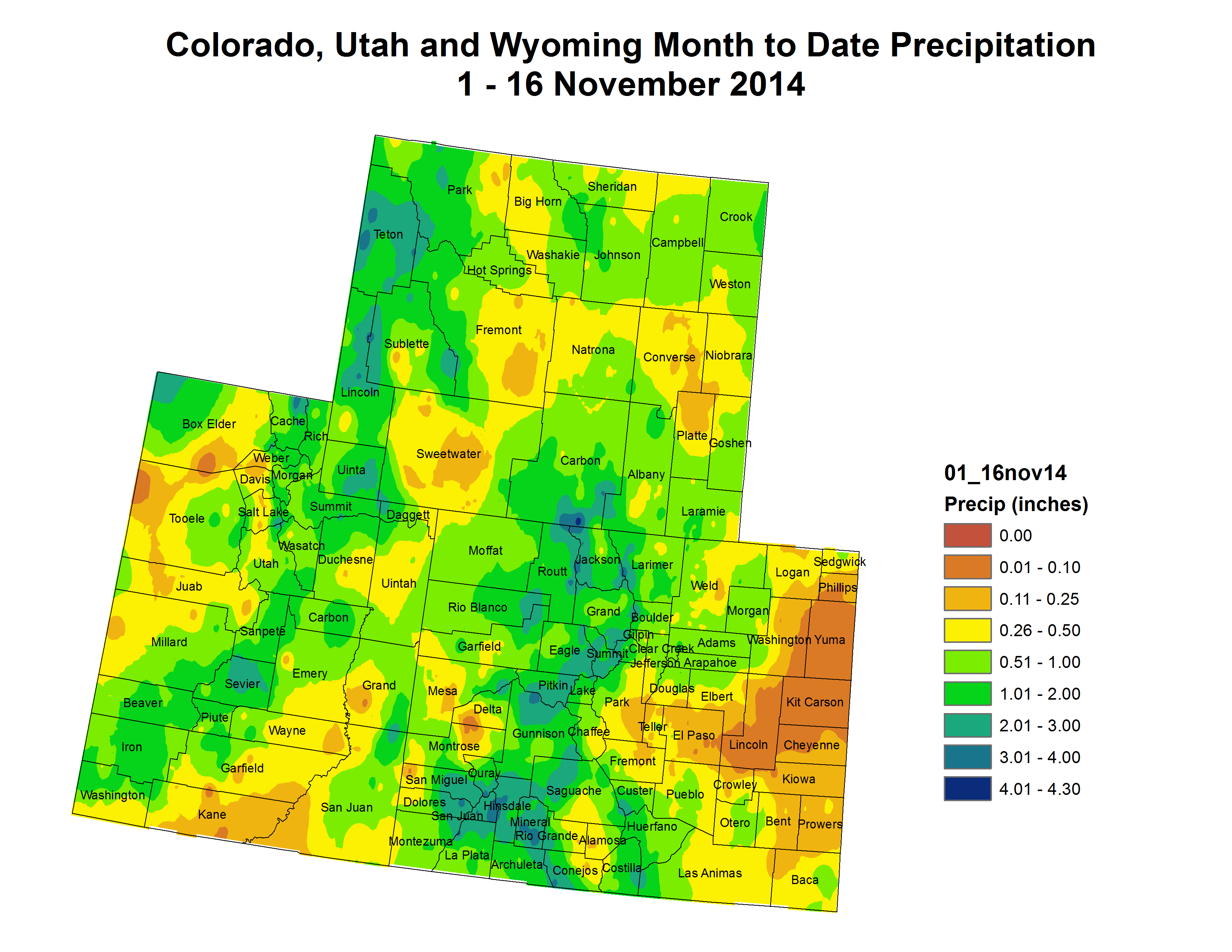
Above average snowfall so far in November for Colorado Springs & Pueblo. A little below average for Alamosa.#cowx pic.twitter.com/oB8WRtYo9A
— NWS Pueblo (@NWSPueblo) November 19, 2014
From The Pueblo Chieftain (Chris Woodka):
Navigating slick streets over the weekend and watching green lawns re-emerge from a white blanket, many people might have thought the early winter weather of late unusual. It’s not. This is when it is supposed to snow.
“Considering the deficit we had coming into last week, it seemed like a lot, but we’re really right back at normal,” said Charles Kuster, who’s been watching the weather around his Leadville home for the past 30 years. “I’m looking for more snow at the end of this week.”
The polar front that moved into Colorado one week ago left anywhere from 6 inches to a foot of snow in most places in the Arkansas River basin, while a second storm moved through late Saturday and early Sunday with almost as much, according to the Community Collaborative Rain Hail & Snow Network.
In Leadville, where the Arkansas River headwaters begin, 27 inches has fallen since the beginning of the month, Kuster said. That’s more than twice the average for November, but September and October were far below normal.
Conditions are similar throughout the valley, and most water indicators for the Arkansas Valley are right where they’re supposed to be at this time of year.
Arkansas River levels below Pueblo Dam dropped Saturday as winter water storage began, but are right on historic averages.
Snowpack at Snotel sites maintained by the Natural Resources Conservation Service are at 114 percent of median, which is better than the rest of the state. Those readings won’t mean much until next spring.
Precipitation levels for Pueblo were at 11.57 inches Monday, just 0.41 inches below normal.
Quagga mussels seem to have made it downstream of Glen Canyon Dam http://t.co/X44Qlud1fp #ColoradoRiver
— John Fleck (@jfleck) November 17, 2014
"The tar sands reserves contain 2x amount of carbon emitted by entire global oil industry—in all of human history." http://t.co/InPA6ZGz6V
— COLab, the Colorado News Collaborative (@colabnewsco) November 18, 2014
BREAKING: The Senate just voted not to approve the #KeystoneXL pipeline http://t.co/VCtqbhxXQk pic.twitter.com/6ETisS3y4g
— Climate Desk (@ClimateDesk) November 18, 2014
Check out @NACWA's Ken Kirk talking about the past, present and future of clean water http://t.co/Td1AFSJgNC #WaterValues
— David McGimpsey (@DTM1993) November 18, 2014
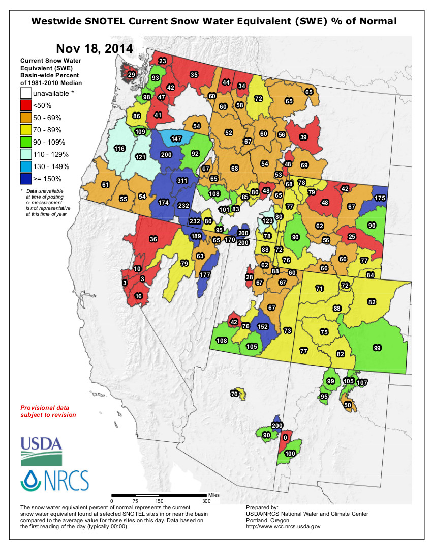
Click here to go to the Intermountain West Climate Dashboard from the Western Water Assessment. Here’s an excerpt:
Highlights
October was much drier than average over most of the region. The first half of November has been more mixed for precipitation, with the Colorado and Wyoming mountains faring the best, and much of Utah remaining on the dry side. After a very slow start to the season, the region’s snowpack has improved markedly since November 1, but is still below normal in most basins. An El Niño event is still likely to occur by spring, but the latest forecasts have again backed off slightly on the odds.

From The Mountain Mail (Joe Stone):
The Upper Arkansas Water Conservancy District board of directors met Thursday in Salida despite wintry road conditions preventing several directors and others from attending the meeting in person. Directors unable to make the drive attended via teleconference, and Cañon City Director of Public Works Bob Hartzman’s report on the Royal Gorge Area Erosion Control Project will be rescheduled.
Board members unanimously approved the 2015 budget as presented by Rich Young of Stotler and Young accounting firm. Young noted that tax revenue projections for the district decreased because of reduced property valuations.
During the budget hearing, Director Jeff Ollinger, Buena Vista, questioned the degree of separation between the conservancy district budget and the Water Activity Enterprise budget. He wondered if an increase in enterprise revenue could translate into a reduction in the district’s mill levy.
District Manager Terry Scanga responded, saying the taxes collected through the mill levy are specifically for the protection of water rights within conservancy district boundaries. Revenue generated through the mill levy, Scanga said, pays for legal fees, court filings and other costs necessary to ensure residents’ water rights are protected. While the conservancy district operates as a governmental entity to protect regional water rights, Scanga said the Water Activity Enterprise operates as a business that uses revenue generated primarily by providing augmentation water to clients. Scanga said those revenues are necessary for the enterprise to acquire additional water sources to meet growing demand.
In other business Upper Ark district directors:
Voted to oppose District 2 Water Court case 2014CW3049, filed by Fremont Paving & Redi-Mix Inc., to change the use of an agricultural water right on the Plum Creek Ditch to augmentation. Learned from Scanga that the state engineer is working to develop new rules that would allow new wells to be developed without a full augmentation plan, similar to wells drilled prior to 1985. Learned from consultant Ken Baker that Senate Bill 14-23, which Gov. John Hickenlooper vetoed this year, will be reintroduced during the next legislative session. Learned from Baker that a bill to provide for management of “invasive phreatophytes” will also be introduced in the legislative session. Phreatophytes are deep-rooted plants that draw water directly from the water table. Learned that Cañon City officials had contacted the Upper Ark district to inquire about purchasing augmentation water. Learned from attorney Kendall Burgemeister that the district’s stipulation in Water Court case 11CW61 has been approved. Adjourned to executive session “to provide direction to staff and receive legal advice for potential purchase of property and water rights.”
More Upper Arkansas River Water Conservancy District coverage here.