
Day: October 8, 2015
The latest ENSO discussion is hot off the presses from the Climate Prediction Center
Click here to read the discussion. Here’s an excerpt:
ENSO Alert System Status: El Niño Advisory
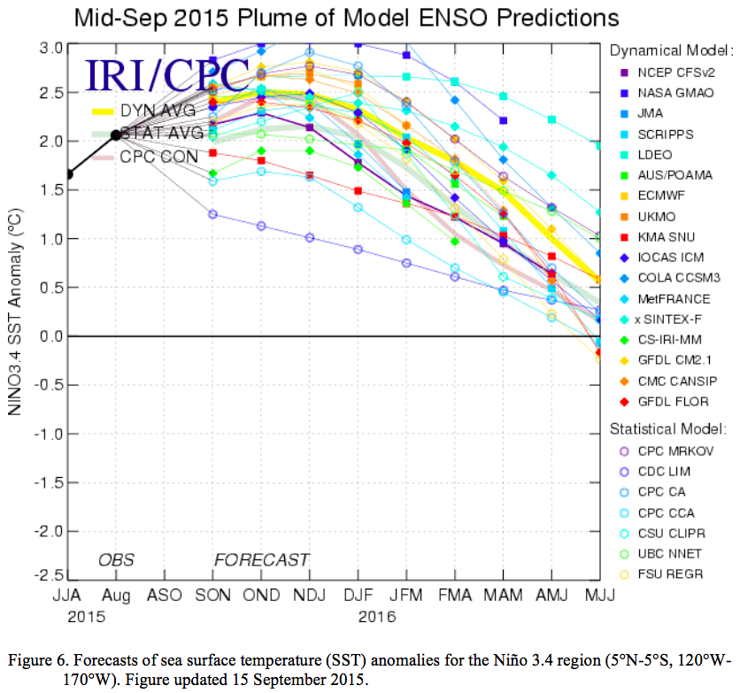
Synopsis: There is an approximately 95% chance that El Niño will continue through Northern Hemisphere winter 2015-16, gradually weakening through spring 2016.
During September, sea surface temperature (SST) anomalies were well above average across the central and eastern Pacific Ocean. The Niño indices generally increased, although the far western Niño-4 index was nearly unchanged. Also, relative to last month, the strength of the positive subsurface temperature anomalies decreased slightly in the central and eastern Pacific, but the largest departures remained above 6°C. The atmosphere was well coupled with the ocean, with significant low-level westerly wind anomalies and upper-level easterly wind anomalies persisting from the western to the east-central tropical Pacific. Also, the traditional and equatorial Southern Oscillation Index (SOI) values became more negative (stronger), consistent with enhanced convection over the central and eastern equatorial Pacific and suppressed convection over Indonesia. Collectively, these atmospheric and oceanic anomalies reflect a strong El Niño.
All models surveyed predict El Niño to continue into the Northern Hemisphere spring 2016, and all multi-model averages predict a peak in late fall/early winter. The forecaster consensus unanimously favors a strong El Niño, with peak 3-month SST departures in the Niño 3.4 region near or exceeding +2.0°C. Overall, there is an approximately 95% chance that El Niño will continue through Northern Hemisphere winter 2015-16, gradually weakening through spring2016 (click CPC/IRI consensus forecast for the chance of each outcome for each 3-month period).
Across the United States, temperature and precipitation impacts from El Niño are likely to be seen during the upcoming months (the 3-month seasonal outlook will be updated on Thursday October 15th). Outlooks generally favor below-average temperatures and above-median precipitation across the southern tier of the United States, and above-average temperatures and below-median precipitation over the northern tier of the United States.
#Drought news: Slow start to snow season in #Colorado

US Drought Monitor October 6, 2015

West Drought Monitor October 6, 2015

Colorado Drought Monitor October 6, 2015
Click here to go to the US Drought Monitor website. Here’s an excerpt:
Summary
Record rains and flooding inundated much of eastern and central South Carolina and extreme southeastern North Carolina as a very slow moving upper-air low over the Southeast funneled tropical moisture from Hurricane Joaquin (stalled over the central Bahamas) into the southern Atlantic Coast region for several days. More than 10 inches of rain fell on the eastern half of South Carolina, and well over 20 inches drenched east-central sections of the state. During the first 6 days of October, maximum Carolina storm amounts totaled 26.88 inches at Mt. Pleasant, SC, and 22.25 inches at Calabash, NC. Heavy rains (more than 2 inches) also fell across much of the eastern third of the Nation, easing or eliminating lingering short-term drought and dryness. An unsettled weather pattern in the West and High Plains also brought unseasonably heavy rains to parts of California, the Great Basin, Southwest, and northern third of the Rockies and Plains. Tropical moisture from former Pacific Hurricane Marty fueled heavy rains in New Mexico and west Texas. Wet weather continued across most of Alaska and Hawaii easing drought and dryness while light to moderate showers across southern Puerto Rico maintained conditions. In sharp contrast, mostly dry weather occurred throughout the Pacific Northwest, Great Plains, and Mississippi Valley. Ever since record wet May and June rains eliminated long-term drought in Texas and Oklahoma, very little precipitation has fallen in parts of the southern Great Plains and lower Mississippi Valley since early July, creating large short-term (at 2- and 3-months) deficits and extreme drought, especially from eastern Texas into central Mississippi…
California and Great Basin
With September and October normally one of the driest months in California, any significant rain (more than 0.5 inches) that falls during this time will usually produce large percentages. This was the case this week when a strong upper-air trough (low pressure) affected the West Coast, drawing in Pacific moisture to most of California and the Great Basin. Unseasonably heavy precipitation (0.5 to 1 inch, locally to 2 inches) was observed in extreme southwestern California (near San Diego vicinity), the Sierra Nevada, and most of northern and western Nevada including the Las Vegas area. Although the rains were welcome and aided in the suppression of wild fire conditions and increased topsoil moisture, it did little for the long-term drought and reservoir storages, thus no changes were made to the drought map. At the end of September, the water conservation efforts in California were noticeable when compared to last year. The amount of water saved came to about 705 KAF – so that this year’s major reservoir storage was only slightly below the storage from a year ago when there were no mandatory water restrictions…
Lower Mississippi Valley and Southern Plains
While the East Coast was getting soaked, a dry week throughout these two regions worsened short-term dryness and drought. The only exception was tropical moisture from remnants of Pacific Hurricane Marty that brought 0.5 to 2 inches of rain to extreme southwestern and western Texas and the Oklahoma Panhandle (which were mostly drought-free), although a small area of D0 and D1 in west-central Texas Panhandle (near Lubbock) was improved a category. Elsewhere, however, after much of Texas and Oklahoma endured record May and June rains and flooding that quickly erased the long-term (hydrological) drought, dry and warm weather since early July has rapidly brought back short-term (topsoil) drought. As a comparison, the Madill, OK Mesonet station measured 43.61 inches of rain from April 1-July 8, and only 1.16 inches in the 89 days since then. In Texas, Muenster (Cooke County) recorded 41.67 inches during April 1-June 30, 4.40 inches July 1-September 30, and only 1.91 inches since July 9. At the USHCN station Blanco (Blanco County), 8.55 inches fell on May 24, but only 0.48 inches since July 1 – so it seems likely that Blanco received as much rain in 14 minutes on May 24 as in the most recent 140,000 minutes (97 days). In Arkansas, several stations established new record lows (Minden 0.02”; Pine Bluff 0.03”; Shreveport 0.07”; and Little Rock 0.12”) for the driest September ever.
During the past 90-days, portions of central and northeastern Texas, southeastern Oklahoma, northern Louisiana, southern Arkansas, and west-central Mississippi have measured less than 2 inches, with several sites reporting under an inch. Normally, central Texas receives 6-8 inches, northeastern Texas and southeastern Oklahoma 8-10 inches, and northern Louisiana, southern Arkansas, and west-central Mississippi 10-15 inches during this 90-day period. This translates into a large area with less than 25% of normal precipitation, and deficiencies ranging from 4-6 inches (central Texas) to 8-12 inches in northern Louisiana and west-central Mississippi. Accordingly, widespread 1-category downgrades were made based upon the severity of the SPIs at 2- and 3-months, plus other products and indices. Fortunately, the record wet May and June in Texas has left statewide monitored reservoirs at 78.6% full as of October 7, although USGS average 28-day stream flows are generally below to much-below normal, as are river gauges in most of Louisiana, southern Arkansas, and Mississippi. According to USDA/NASS statewide statistics on Oct. 4, the percentage of topsoil/subsoil moisture short to very short was: Arkansas (81/74), Mississippi (80/76), Louisiana (69/60), Texas (67/64), and Oklahoma (50/54)…
Northern and Central Plains
A slow-moving frontal system, embedded with waves of low pressure and ample moisture to work with, produced unseasonably heavy precipitation from the Southwest northeastward into the northern Plains. The greatest amounts in the Plains included 1-2 inches in central Montana, western South Dakota, and north-central Nebraska. Most of this area, however, was drought free, except for D0 in eastern and central Montana and southwestern South Dakota where the abnormal dryness was reduced. In contrast, drier weather affected eastern sections, and D0 was expanded as short-term shortages increased (as mentioned in the Midwest summary for the eastern Dakotas and northeastern Kansas)…
Pacific Northwest and Northern Rockies
Little or no precipitation fell across the Northwest as temperatures averaged close to normal. With much of the region in D2 or D3 and the rainy season normally commencing later this month and into November, no changes were made this week. In the north-central Rockies, however, the continued wet weather in southeastern Idaho and northern Utah was enough to warrant a 1-category improvement there, matching the water reservoir storage conditions of the Snake River. Slight improvements were made in the Boise basin due to a wet July and September that significantly helped preserve the reservoir storage within the basin, and which now has the best reservoir conditions in Idaho outside of the Bear River basin in the southeast…
Southwest
The same slow-moving storm system in the Great Basin and Rockies also dropped light to moderate (0.5-2 inches) rain across parts of northern and central Arizona and southern Utah while tropical moisture from the remnants of Pacific Hurricane Marty generated 0.5 to 3 inches of rain in central and eastern New Mexico and west Texas. Most of the significant rains fell on non-drought areas, although the 1-2 inches in southeastern New Mexico was enough to reduce or eliminate short-term deficits (one D0 area shrunk, one erased). Since it had been dry in central and northern Arizona for a while, the rains came in time to prevent degradation…
Looking Ahead
For the upcoming 5-day period (October 8-12), mostly light (0.25-0.75 inches) precipitation will occur in the eastern third of the Nation, with totals of up to 1-1.5 inches possible in the northern Rockies, Great Lakes region, central Appalachians, and eastern Florida. Farther west, heavy precipitation (1-3 inches) is expected in the southern High Plains and Rio Grande Valley, and 2-7 inches in western Washington. Elsewhere, little or no precipitation is expected. Temperatures across the lower 48 States will average above normal, especially in the West and Plains.
For the ensuing 5 days (October 13-17), the odds favor above-median precipitation from the Southwest northeastward into the central Corn Belt, and throughout the southern two-thirds of Alaska. In contrast, sub-median precipitation is favored in the Northwest and Southeast. A strong tilt toward above-normal temperatures is expected in the western half of the U.S., with lower but still above-normal odds in the eastern half of the nation. Alaska also favors above-normal temperature chances, especially in the south.
Bureau of Reclamation Seeking Ways to Measure Food for Threatened and Endangered Fish

Here’s the release from the US Bureau of Reclamation (Lauren Meredith):
The Bureau of Reclamation is launching a $30,000 prize competition seeking improved methods to measure the food resources available for threatened and endangered fish. Advancing technology for monitoring how food is available for fish species can lower the cost and improve the effectiveness of fish recovery efforts.
“Protecting and restoring river systems are vital to ensuring that watersheds are healthy and can continue to meet the West’s water needs,” said Commissioner Estevan López. “Encouraging innovation and collaboration between the federal government and the private sector allows us all to do our jobs better.”
Millions of dollars are spent annually on restoration activities like changing flow regimes, reconstructing wetlands and adding natural structural elements. These efforts to improve and restore habitats are key to the recovery of salmon, trout and other critical fish species. A critical way to learn the effectiveness of habitat recovery is to measure the food resources available to fish species targeted for recovery and protection. Despite its importance, measuring food resources has proven difficult.
The top one to three submissions will receive $10,000 to $15,000 in prize money, totaling no more than $30,000. The winning solutions will help fish recovery managers evaluate the food available to impacted fish species under various habitat restoration strategies.
Reclamation is collaborating with National Oceanic and Atmospheric Administration Fisheries, U.S. Geological Survey, U.S. Fish and Wildlife Service and the U.S. Army Corps of Engineers to lead this competition.
The prize competition closes on November 16, and winners will be announced by January 29, 2016. To submit your ideas, please visit https://www.innocentive.com/ar/challenge/9933647. Learn more about the prize challenges at http://www.usbr.gov/research/challenges/.
On October 7 and 8, the Obama administration is celebrating the five-year anniversary of Challenge.gov, a historic effort by the federal government to collaborate with members of the public through incentive prizes to address our most pressing local, national, and global challenges. True to the spirit of the President’s charge from his first day in office, federal agencies have collaborated with more than 200,000 citizen solvers—entrepreneurs, citizen scientists, students, and more—in more than 440 challenges, on topics ranging from accelerating the deployment of solar energy, to combating breast cancer, to increasing resilience after Hurricane Sandy. Read more here.
Study Ties Warming Temps to Uptick in Huge Wildfires — Climate Central
From Climate Central (Bobby Magill):
Catastrophic wildfires in the Western U.S. are often discussed in superlatives these days, with blazes burning land more violently and more frequently in recent years than at any point on record. Those changes are considered partly driven by global warming, and a new University of Wyoming study shows that even the smallest increase in average temperature — 0.5°C (0.9°F) — could bring a dramatic increase in wildfire activity at higher elevations.
The study also suggests that global warming may be ushering in an era of high-elevation wildfires unlike any seen in more than 1,000 years…
The new study, published Monday in the Proceedings of the National Academy of Sciences, provides more evidence that even a small amount of warming has a huge effect on wildfire.
University of Wyoming researchers studied charcoal samples representing 2,000 years of wildfire that were taken from lake beds in a subalpine forest — above 8,000 feet — in northern Colorado’s Mount Zirkel Wilderness near Steamboat Springs. With them, they were able to measure the increased wildfire frequency during a period of global warming similar to today.
That period, called the Medieval Climate Anomaly, or MCA, was about 1,100 to 1,200 years ago, when average temperatures in Northern Colorado were 0.5°C warmer than they were the preceding century, but moisture levels were not dramatically different.
Before the warm period, about 50 percent of the sites the researchers studied burned per century, increasing to 83 percent during the warm period and declining to 33 percent afterward. Most sites burned roughly at a rate of every 360 years prior to the warm period, increasing to every 120 years during the warm period — a 260 percent increase. Fire frequency declined before temperatures cooled, however, and the researchers think that happened because there was little forest left to burn.
The study is the first to discover how much land across an entire mountain range burned over a period of 2,000 years and shows that large wildfires similar to those burning today only occurred when temperatures increased like they have in recent years, the study’s lead author, University of Wyoming Ph.D. candidate John Calder, said.
“When we look into the past for evidence of these large wildfires we only see them one time when temperatures rose about 1°F,” he said. “Our study then adds more evidence that the recent increase in large wildfires is related to climate change because the only time we see these types of large wildfires in the last 2,000 years is when we had a similar amount of warming.”
The study only applies to dense high elevation forests, not those that have burned at lower elevations elsewhere in Colorado.

West Fork Fire June 20, 2013 photo the Pike Hot Shots Wildfire Today

Hewlett Fire May 5, 2012

Black Forest Fire June 2013 via CBS Denver

Weber Fire near Mancos June 2012 via MNGInteractive.com

Four Mile Canyon Fire September 6, 2010

Waldo Canyon Fire. Photo credit The Pueblo chieftain.

High Park Fire June 14, 2012
#COWaterPlan: Aurora comments submitted — conservation stretch goal of 400,000 hasn’t been “verified”
From The Aurora Sentinel (Rachel Sapin):
“A statement implying that the efforts that cities and water suppliers have used to plan for water supply projects is based on ‘blind hope’ instead of careful analysis is misleading and unacceptable,” wrote Aurora Mayor Steve Hogan to Gov. John Hickenlooper in response to the second draft of the plan, released in September.
The plan — which says that the state will run out of water for a fast-growing population by 2050 — presents a dizzying array of solutions for more water that include improving the permitting process, funding more storage and reducing the state’s projected 2050 municipal water demands by 400,000 acre-feet through conservation. That equates to a nearly 1-percent annual reduction in water use for the state’s cities and towns, according to the advocacy groups Conservation Colorado and Western Resource Advocates.
Joe Stibrich, a water resources policy manager with the city, said the plan also discourages more water diversions, stating Colorado watersheds and ecosystems cannot handle any more of them.
“In fact, new diversions and storage will be needed to develop collaborative, regional projects,” Stibrich and other Aurora Water staff wrote in a response to Hickenlooper about the plan.
Stibrich said Aurora Water is also concerned about the 400,000 acre-feet stretch goal because the number could overly burden Front Range cities.
“The concept itself is good but it’s a number that hasn’t been verified,” he said, adding that the stretch goal will not likely be achievable under current policies and with existing technology. Stibrich said he would like to see experts work with legislators to come up with an achievable range rather than a specific number.
A hearing on the plan in its second draft drew mostly advocacy groups to the Aurora Municipal Center in September. Those who testified at the meeting had concerns similar to those expressed by city officials.
Barbara Biggs, chair of the metro basin roundtable, also questioned the 400,000 acre-feet goal put into the plan at the meeting.
“Applying it in a one-size-fits-all goal makes us nervous. We think the stretch goal needs to recognize what different communities are going to be able to accomplish different things in their water conservation efforts,” she said…
Anne Castle, an expert with the University of Colorado’s Getches-Wilkinson Center for Natural Resources, Energy, and the Environment, testified that the second draft of the water plan remained too vast in its goals and vague in its action plan.
“We’re recommending the hundreds of action items in the plan be prioritized,” she said. “We need to prioritize those actions in order to have a practical implementation strategy. We can’t do everything at once.”
Castle recommended that the state’s water conservation board come up with a criteria for funding water projects and programs. Right now, the plan says the state will need $20 billion to pay for necessary water projects in the coming decades without specifically describing what those water projects are.