Town watching Coal Creek study — The Crested Butte News

Crested Butte
Crested Butte

From The Crested Butte News (Mark Reaman):

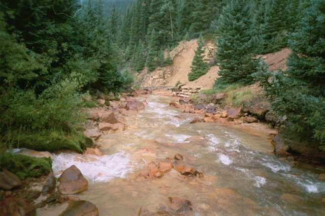
Crested Butte will ask the state to allow the town to be directly involved in the Colorado Water Quality Control Commission’s proceedings dealing with Coal Creek and temporary modifications currently in place.

The request for so-called “Party Status” comes at the request of the Coal Creek Watershed Coalition (CCWC). Coalition board president Steve Glazer came to the council Monday, September 21 with the request.

Temporary modifications of in-stream water quality standards have been in place for Lower Coal Creek for more than 20 years. Those standards are reviewed every three years by the state.

At the 2012 hearing, the state required U.S. Energy, the mining company responsible for the potential molybdenum mine and current water treatment plant on Mt. Emmons, to develop a study plan to address uncertainty regarding pollution sources impacting Coal Creek. Data collection from the study will culminate this year.

The Water Quality Control Commission is set to review the temporary modifications and evaluate progress on the study. Glazer feels the process will likely be continued into 2016 and may include new rule-making involving new standards for Coal Creek.

Given the town’s inherent interest in the watershed, CCWC felt it appropriate to have the town participate.

#ColoradoRiver: Grand County rancher uses 2013 law to leave water in Willow Creek without penalty — Hannah Holm #COriver

From the Grand Junction Free Press (Hannah Holm):

A Grand County rancher has become the first person in Colorado to use a 2013 state law to intentionally leave water in a stream without fear of diminishing his water right. Working with the Colorado Water Trust , Witt Caruthers developed a plan to curtail diversions from Willow Creek when its flows drop to critical levels.

The additional flows will benefit half a mile of Willow Creek and then four and a half miles of the upper Colorado River before encountering the next downstream diversion, where another water user could potentially take the water. This stretch of the Colorado River has been heavily impacted for decades by upstream diversions across the Continental Divide to Front Range cities and farms.

The 2013 law, Senate Bill 13-019, allows some Western Slope water right holders to reduce their water use in up to five out of any consecutive ten years without having the use reductions count against them in water court calculations of “historic consumptive use.” This reduces the “use it or lose it” disincentive for conservation in Colorado water law.

The law applies only to water users in Colorado Division of Water Resources Divisions 4 (Gunnison River Basin), 5 (Colorado River Basin) and 6 (Yampa, White and North Platte River Basins). In order to qualify for the law’s protections, the water use reductions must be the result of enrolling land in a federal land conservation program or participating in an officially-sanctioned water conservation or banking program.

Jim Pokrandt of the Colorado River District, which approved Caruthers’s conservation program, told the Sky Hi Daily News that “we’re glad to be in the vanguard and helping the agricultural community protect their water rights when they want to lend the water rights to environmental purposes.” The same article quotes Caruthers as saying that he and his partners sought to “one, preserve our water rights but also to contribute to the overall maintenance of the ecosystem there by leaving water in the stream when it wasn’t needed.”

The Colorado Water Trust has also pioneered the use of other voluntary and market-based tools for landowners to share water with streams without diminishing their water rights. These include a 2003 law that created a streamlined process for water users to make short-term leases of water to the state for environmental purposes. The Trust first used this tool in 2012 by brokering a deal to support flows in the Yampa River. It has since been used in several other places.

Support and funding for such innovative water conservation efforts is rising as Colorado and the other states and cities that share the Colorado River are seeking ways to prop up water levels in Lakes Powell and Mead in the face of long-term drought.

This is part of a series of articles coordinated by the Water Center at Colorado Mesa University in cooperation with the Colorado and Gunnison Basin Roundtables to raise awareness about water needs, uses and policies in our region. To learn more, go to http://www.coloradomesa.edu/WaterCenter. You can also find the Water Center on Facebook at https://www.facebook.com/WaterCenter.CMU or on Twitter at https://twitter.com/WaterCenterCMU.

Willow Creek via the USGS

#ColoradoRiver: Middle #Colorado Watershed Council Shoshone Power Plant Tour October 26 #COriver

From email from the Middle Colorado Watershed Council:

Come join the Middle Colorado Watershed Council for a tour of the Shoshone Hydroelectric Power Plant east of Glenwood Springs. The Plant plays a pivotal role in western water not because of the power it generates, but because it holds the one of the oldest, largest water rights on the river. The senior right to 1,250 CFS means that water must flow down the Colorado, and it’s a non-consumptive use, so that water is flowing right back into the river for later use. We will learn about the Plant’s legacy over the past century, and what the water right means to us on the Western Slope. Registration is only open through October 12, and all participants must submit a facility waiver form at registration.

Location: Shoshone Power Station, Glenwood Canyon, CO
Date: October 26, 2015
Registration Deadline: October 12, 5:00pm
Time: 9:00am – 12:00pm
Cost: Free
Registration: Online through Eventbrite
Contact: For more information, contact Dan at info@midcowatershed.org

Click here to register.

Link to waiver form.

#Drought news: Abnormal dryness (D0) increased over eastern #Colorado in areas where 60-day <=50% of normal

Click here to go to the US Drought Monitor website. Here’s an excerpt:

Summary

Although increasingly wet weather has been noted over parts of the East, any rain falling after Tuesday morning (8 a.m., EDT) will be incorporated into next week’s U.S. Drought Monitor. For this week’s analysis, above-normal temperatures prevailed across much of the country, though heavy rain and near-normal temperatures were observed over parts of the Gulf Coast and Southeast. In addition, moderate to heavy rain was noted in western portions of the Corn Belt. In contrast, protracted dryness prevailed over the Northeast, while seasonably dry weather continued over the western U.S…

Central Plains

Above-normal temperatures accompanied scattered showers, with little widespread change to this week’s drought depiction. Abnormal Dryness (D0) was increased over eastern portions of Colorado, coinciding with locales where 60-day rainfall has tallied 50 percent of normal or less. There were no changes to the Moderate Drought (D1) in Kansas, where this week’s light shower activity (generally 0.5 inch or less) was insufficient for drought reduction…

Northern Plains

Hot, dry conditions prevailed, with temperatures averaging more than 10°F above normal. Despite the 90-degree readings and a lack of rain during the period, changes to this week’s drought designation were generally minor. Abnormal Dryness (D0) was expanded over southeastern Wyoming into northwestern Nebraska, where pronounced short-term precipitation deficits (60-day rainfall totaling 30 to 50 percent of normal) has led to locally pronounced topsoil shortages…

Southern Plains and Texas

Despite areas of beneficial rain in the west and along the Gulf Coast, the overall trend toward intensifying “flash drought” continued. The intensity and coverage of Abnormal Dryness (D0) to Extreme Drought (D3) increased from southern Oklahoma southwestward across central Texas to the Big Bend. Daytime highs reaching into the upper 90s coupled with another dry week continued to accelerate soil moisture losses, with 90-day rainfall tallying a paltry 5 to 20 percent of normal over many of the Lone Star State’s central drought areas. Pronounced short-term dryness has also intensified over central and southern Oklahoma, where 60-day rainfall has totaled mostly less than 30 percent of normal. Meanwhile, widespread showers and thunderstorms (0.4 to 2 inches, locally more) boosted soil moisture for winter crops and pastures on the southern High Plains and eased D0 along the Texas-New Mexico border. Likewise, 1 to 4 inches of rain reduced D0 to D3 in southern and southeastern Texas, though the heaviest rain largely bypassed the core Texas drought areas…

Western U.S.

The overall trend toward drought persistence continued, though isolated showers were noted in the Pacific Northwest and lower Four Corners. After last week’s cool down, much-above-normal temperatures returned to California and the Great Basin. In the north, most of the region’s core Extreme Drought (D3) areas were dry. However, light to moderate showers on Washington’s Olympic Peninsula (mostly an inch or less) coupled with last week’s heavier rain continued to stave off D3 expansion. Across the California and the Great Basin, drought remained unchanged as the region continued through its climatologically dry summer season. However, heat exacerbated the impacts of the region’s historic drought, with daytime highs reaching or eclipsing 100°F from central California into the southern Great Basin. In the Four Corners States, additional assessment from the field in the wake of last week’s locally heavy rain resulted in further reductions of Abnormal Dryness (D0) and Moderate (D1) in southeastern Arizona and southwestern New Mexico…

Looking Ahead

The complex interaction between a blocking high over eastern Canada, a stationary upper-air low over the Southeast, and Hurricane Joaquin (or the remnants of) will bring the threat of heavy rain to the eastern third of the nation. Rainfall may total 3 to 4 inches (locally much more) across the Southeast, Mid Atlantic, and Northeast, pending the final track of Joaquin. Meanwhile, dry weather is expected from Texas into the upper Midwest. Farther west, a Pacific storm system will move ashore, bringing the potential for locally heavy showers from central and northern California into the northern Rockies. Dry weather is expected over the Southwest, though some late-season showers may arrive in the Four Corners at the end of the period. The NWS 6- to 10-day outlook for October 6 – 10 calls for above-normal precipitation and near- to above-normal temperatures nationwide, with drier-than-normal conditions confined to the lower Southeast.

Just for grins here’s a slideshow of late September early October US Drought Monitor maps for the past few years:

This slideshow requires JavaScript.
NASA to test [snowpack] data technique in upper Rio Grande Basin — The Santa Fe New Mexican

Combined lidar and aerial mapping

From the Associated Press (Dan Elliott) via the Santa Fe New Mexican:

NASA is providing drought-stricken California with valuable data about how much water is locked up in the scant Sierra Nevada snow, and now Colorado is trying the technique in the mountains where the Rio Grande begins its journey to New Mexico and Texas.

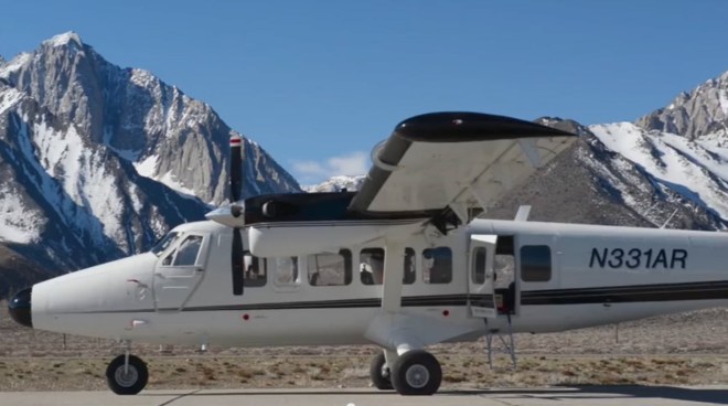
An airplane called the Airborne Snow Observatory flies over California’s Tuolumne River Basin east of San Francisco during peak snow months, using scanners to collect data on how deep the snow is and how much of the sun’s warming rays are bouncing off. That helps project when the snow will melt and how much water it will release into rivers for cities, farms and wildlife…

“Once the water managers get a look at the data, they say, ‘I like that,’ ” said Frank Gehrke, chief of the California Cooperative Snow Surveys Program. NASA has been providing California with snow data from the Tuolumne Basin since 2013, and flights will resume there next spring.

Colorado signed up for three flights over the Rio Grande Basin in the south-central part of the state. The first were in March and September of this year. The third will be next spring…

Estimating how much Colorado snow will melt into the Rio Grande is difficult. The mountains block weather radars that could help gauge how much precipitation is falling, said Joe Busto of the Colorado Water Conservation Board.

Colorado will use the NASA data to improve computer modeling for runoff forecasts…

The Airborne Snow Observatory, a propeller-driven plane, sweeps back and forth over mountain snowfields scanning with lidar — the term combines “light” and “radar” — and an imaging spectrometer.

Lidar measures snow depth by bouncing a laser off the surface and comparing that to an aerial survey done without snow. Coupled with snow density data from ground sites and computer modeling, researchers can project how much water is in the snow.

The spectrometer measures how much sunlight the snow is reflecting and absorbing. That allows researchers to project when it will melt.

The ground sites, scattered across the West, are the primary source of data for most snowmelt projections. U.S. Department of Agriculture employees trek to some sites to measure and weigh the snow. Other sites are automated.

Painter said the airborne survey won’t eliminate ground sites, but he foresees a day when aerial surveys become the standard. Satellites might also play a role, but airplanes can provide a level of detail and frequency that spacecraft cannot, Painter said.

“At least not yet. Maybe in 50 years,” he said.

jplaircraftsnowsurveytuolommebasin

#COWaterPlan: “There is a lot of misunderstanding on water issues” — Leroy Garcia

Colorado Water Plan website screen shot November 1, 2013

From The Pueblo Chieftain (Chris Woodka):

One of the outcomes of the Colorado water plan has been to draw new voices to talk about a question that’s older than the state itself: How can a sparse resource be used to meet the needs of a growing population?

So, a group primarily concerned with the Colorado River recently reached out to Pueblo to gather perspective.

Nuestro Rio — “our river” in Spanish — invited Puebloans to talk about water on the last day for comments on the final plan recently.

“My concern was that people could become more familiar with it and to make sure Southern Colorado knew it has a voice,” said state Sen. Leroy Garcia, D-Pueblo, who helped set up the meeting.

About 50 people, ranging from elected o_cials to farmers, attended. Also present was state Rep. Ed Vigil, D-Fort Garland, a member of the Interim Water Resources Review Committee.

“One of the goals of Nuestro Rio is to remind people of the importance of the river but to also involve more young people,” Garcia said.

While Nuestro Rio formed to emphasize the importance of the Colorado River to Latinos, a series of statewide outreach meetings showed there are concerns common to all rivers in the state, said Nita Gonzales, Colorado director for the organization.

“The main thing we heard was that diverting water cannot be the only solution,” Gonzales said. “Rivers are critical to Latino families, and before we move to big projects, we have to ask how do you protect the rivers.”

That includes maintaining agricultural uses that are the foundation for the economic wellbeing of many Latinos, Gonzales said.

“The other thing we heard is that elected officials are not as involved in water, but it is so important to the communities to make sure it is addressed in policy and budgets,” she said.

Garcia agreed.

“My own colleagues have to see this as one of the most important issues in the state,” he said. “We talk about transportation, education and economic development, but none of those things happens without water.”

On the state water plan, Garcia said he favors some of its openended approaches.
“There is a lot of misunderstanding on water issues,” he said. “The plan is very basin specific.”

@NWSPueblo: The September 2015 Climate Review and October Preview across Southern Colorado

From the National Weather Service Pueblo office:

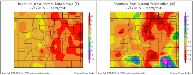
September of 2015 was very warm and mainly dry across much of Colorado. A moist Pacifc weather system brought some rain to southwest and central portions of the state through the first couple days of month, with another Pacific weather system moving across the state on September 22nd and 23rd, bringing beneficial rain to portiions of the southeast Plains. The following graphics depict monthly temperature and precipitation departures from normal across the state for the month of September.

departurefromnoralpreciptemp0901thru09292015nwspueblo

The preliminary average temperature over the past month of September in Pueblo was 71.9 F. This is 7.2 degrees above normal and makes September of 2015 the warmest September on record in Pueblo, smashing the previous record average temperature of 71.0 degrees recorded in September of 1931. Pueblo recorded only 0.03 inches of precipitation through out the month of September. This is 0.74 inches below normal and makes September of 2015 tied with September of 1895 as the 6th driest September on record in Pueblo, remaining just below the trace of precipitation recorded through out September of 1956, 1916 and 1892. Pueblo recorded no snow through out the month of September, which is 0.3 inches below normal.

The preliminary average temperature over the past month of September in Colorado Springs was 67.3 F. This is 6.4 degrees above normal and makes September of 2015 the warmest September on record in Colorado Springs, besting the average temperature of 67.0 degrees recorded in September of 2010. Colorado Springs recorded 0.30 inches of precipitation throughout the month of September. This is 0.89 inches below normal and makes September of 2015 the 19th driest September on record, though remains well above the trace of precipitation recorded in September of 1953 and 1919. Colorado Springs recorded no snow through out the month of September, which is 0.2 inches below normal.

The preliminary average temperature over the past month of September in Alamosa was 58.4 degrees. This is 3.4 degrees above normal and makes September of 2015 tied with September of 1939 as the 3rd warmest September on record in Alamosa, though remains just behind the average temperature of 59.0 degrees recorded in September of 1933. Alamosa recorded 0.78 inches of precipitation through out the month of September, which is 0.13 inches below normal. Alamosa recorded no snow through out the month of September, which is normal.

September 2015 climate data and records for other select locales across south centrral and southeast Colorado can be found here:

http://www.weather.gov/pub/adryandwarmseptembersofar

Looking ahead into October, in Pueblo, the average high and low temperatures of 75 degrees and 40 degrees on October 1st, cool to 64 degrees and 29 degrees by the end of the month, yielding an average monthly temperature of 51.8 degrees. Pueblo averages 0.72 inches of precipitation and 1.3 inches of snow through out the month of October.

In Colorado Springs, the average high and low temperatures of 68 degrees and 41 degrees on October 1st, cool to 58 degrees and 31 degrees by the end of the month, yielding an average monthly temperature of 49.4 degrees. Colorado Springs averages 0.82 inches of precipitation and 2.9 inches of snow through out the month of October.

In Alamosa, the average high and low temperatures of 68 degrees and 30 degrees on October 1st, cool to 55 degrees and 19 degrees by the end of the month, yielding an average monthly temperature of 43.1 degrees. Alamosa averages 0.68 inches of precipitation and 2.1 inches of snow through out the month of October.

Below is the Climate Prediction Center’s (CPC) temperature and precipitation outlook for the month of October, which gives a slight nod to above normal precipitation and equal chances of above, below and near normal temperatures for the month across south central and southeast Colorado.

onemonthetempprecip102015cpc