
Day: April 19, 2018
#Drought news: D4 (exceptional drought) expanded in the Four Corners and NE #NewMexico

US Drought Monitor April 17, 2018.

West Drought Monitor April 17, 2018.

Colorado Drought Monitor April 17, 2018.
Click here to go to the US Drought Monitor website. Here’s an excerpt:
Summary
A powerful spring storm emerged from the West and brought extreme conditions to several regions. For example, historic, late-season snow blanketed portions of the northern Plains, upper Midwest, and Great Lakes region, snarling traffic and severely stressing livestock. Meanwhile, dry, windy weather contributed to a major wildfire outbreak, starting on April 12, and led to blowing dust and further reductions in rangeland, pasture, and crop conditions. Farther east, heavy showers and locally severe thunderstorms swept across portions of the southern and eastern U.S. Elsewhere, unsettled, showery weather lingered in the Northwest, extending as far south as northern California…
A sharp line between no drought and moderate to exceptional drought (D1 to D4) continued to slice across Oklahoma and Texas. On April 15, topsoil moisture was rated 72% very short in Oklahoma, along with 66% in Texas. In stark contrast, topsoil moisture was at least one-third surplus in Mississippi (58%), Tennessee (41%), Arkansas (37%), and Louisiana (34%). In the drought-affected areas, rangeland, pastures, and winter grains continued to greatly suffer. On April 15, nearly two-thirds of the winter wheat was rated in very poor to poor condition in Oklahoma (65%) and Texas (63%). On April 12-13 and 16-17, high-wind events brought blowing dust and a rash of major wildfires to western Oklahoma and portions of neighboring states. As of April 17, the two largest wildfires in Oklahoma had charred more than 300,000 acres of grass and brush and had destroyed more than 100 structures. The Rhea Fire, in Dewey County, had consumed more than one-quarter million acres, while the 34 Complex, in Woodward County, had burned across nearly 70,000 acres…
Heavy snow also blanketed portions of the northern Plains, while dry, windy weather dominated drought-affected areas of the central Plains. The storm contributed to the elimination of severe drought (D2) from the Dakotas, and brought substantial reductions in the coverage of abnormal dryness (D0) and moderate drought (D1). In South Dakota, 2-day April snowfall records were broken on April 13-14 in Mitchell (16.2 inches) and Huron (15.5 inches), while peak gusts were clocked to 60 and 57 mph, respectively. Sioux Falls, South Dakota, received 14.5 inches of snow from April 13-15, and reported a gust to 67 mph on the 14th. Most of Sioux Falls’ snow—13.7 inches—fell on the 14th, easily becoming the snowiest April day on record in that location (previously, 10.5 inches on April 28, 1994). Farther south, however, topsoil moisture was rated 72% very short to short on April 15 in Kansas, along with 61% in Colorado. On the same date, winter wheat in Kansas was rated 46% very poor to poor. In Colorado, there was a significant introduction of exceptional drought (D4) into the southwestern corner of the state, where winter snowfall was abysmal and spring and summer runoff prospects are poor…
Late-season precipitation continued to move ashore as far south as northern California, resulting in some minor reductions in the coverage of abnormal dryness (D0). In the Southwest, however, dry, often windy weather resulted in drought persistence or intensification. Arizona’s rangeland and pastures were rated 86% very poor to poor on April 15, compared to the 5-year average of 30%. On the same date, New Mexico’s rangeland and pastures were rated 50% very poor to poor, while winter wheat was rated 68% very poor to poor. New Mexico’s topsoil moisture on April 15 was rated 91% very short to short. Due to deteriorating agricultural and hydrological conditions, exceptional drought (D4) was expanded in the Four Corners region as well as northeastern New Mexico…
Looking Ahead
A storm system crossing the nation’s northern tier will reach the Northeast on Thursday, bearing rain and snow. A more significant storm will traverse the West and produce heavy snow in the central Rockies before crossing the Plains on Friday. Precipitation totals associated with the storm will be variable, but some drought-stricken areas of the central and southern Plains could receive as much as 0.5 to 2.0 inches of rain. During the weekend, showers and thunderstorms will erupt across the mid-South and spread into the Southeast. By early next week, warm, dry weather should overspread much of the western U.S., while chilly conditions will linger across the South and East.
The NWS 6- to 10-day outlook for April 24 – 28 calls for the likelihood of near- to below-normal temperatures across most of the eastern half of the U.S., while warmer-than-normal weather will cover the West. Meanwhile, near- to below-normal precipitation across the majority of the country should contrast with wetter-than-normal conditions in a few areas, including the Atlantic Coast States and central and southern sections of the Rockies and High Plains.
@CAPArizona accused of manipulating supply and demand #ColoradoRiver #COriver
From H2ORadio:
Officials from Colorado, Wyoming, Utah, and New Mexico recently sent a letter to counterparts in Arizona, hoping to avert a crisis. The problem, if unresolved, could affect people in seven western states.
A potential water war may be breaking out over the Colorado River, a conflict that could pit Arizona against Colorado, and other states. On April 13th, water managers from states in the north of the river system, called the Upper Basin, sent a letter to Arizona officials asking for their continued cooperation in managing the river for the benefit of everyone.
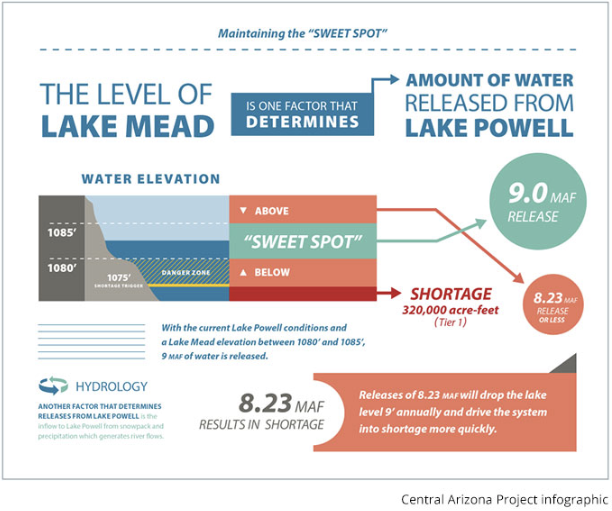
It all started when the Central Arizona Project, managed by Central Arizona Water Conservation District, posted a graphic on its website showing that it could—and should—take more water than it needs from the river—instead of conserving as much as possible. Many people in Colorado, and even in Arizona, think this potential water grab goes too far.
The Colorado River supplies 40 million people with water under a complex set of rules, laws, and agreements among seven states. James Eklund was one of those who signed the letter to Arizona officials. He is the state of Colorado’s representative on the Upper Colorado River Commission. Eklund explained that the Colorado River system has two major reservoirs that are operated to the benefit of everybody in the basin. The reservoir in the Upper Basin is called Lake Powell, which was filled when Glen Canyon Dam was completed, and below it is Lake Mead, which is the product of Hoover Dam.
The Upper Basin states (comprising Wyoming, Utah, New Mexico, and Colorado) send water to Lake Powell to store in order to meet their requirement to deliver supplies to the Lower Basin states of Arizona, Nevada, and California. According to Eklund, the Upper Basin depends on a healthy amount of water in Lake Powell to act as an insurance policy against calls for more water from the Lower Basin.
Think of the reservoirs this way—they are like two bathtubs connected one above the other. When the lower bathtub needs water, the upper one has to let some out. The Central Arizona Project wants to force water to be released from the upper bathtub—even if not needed. This got people in the Upper Basin concerned. Up until this point, the perception was that everyone was acting in everyone else’s interest—all for one, and one for all—but Central Arizona Project’s recent move made it appear it’s acting for its own benefit to the detriment of others—especially those in the Upper Basin.
Eklund said that if we start working in our own self interest at the expense of others, then we start getting into more of a zero-sum game, and that’s a place that’s fraught with peril on this river. He added that they have worked very hard not to have the Upper and Lower basins pitted against each other, but the messaging that the Central Arizona Project put out implies that it wants to game the system.
This maneuver would discourage farmers and cities in Colorado from conserving water to send to the upper bathtub—Lake Powell—to meet Lower Basin requirements. People in the Upper Basin have been working hard to promote those conservation efforts. Jim Lochhead, CEO of Denver Water is concerned enough about this potential water grab that he sent a letter to the managers of the Central Arizona Project on April 16th. He threatens to stop funding some conservation efforts unless the Central Arizona Project shows it is not manipulating the system and is aggressively conserving water with other entities in Arizona.
The potential water war along the Colorado underscores how everybody on the river is tied together—especially in a dry year. James Eklund said that inflow into the system is shaping up to be low this year, and we might skirt by; but, if there are back-to-back dry years like this one, then we are really in a crisis.
A crisis where everyone up and down the Colorado River needs to cooperate.

From Water Deeply (Eric Kuhn, John Fleck):
While some problems on the Colorado River are the result of drought and climate change, Congress set the course for serious trouble in the watershed decades ago by authorizing the Central Arizona Project.
WITH THE POTENTIAL of a Colorado River shortage declaration looming as Lake Mead drops, Arizona is struggling with the politics of who will have to cut their water use, and by how much. As Arizona wrestles, it is important to remember how we got here.
It’s easy to blame today’s problems – an overallocated river and declining reservoir levels – on drought and climate change, and both of these do play a role. But our predecessors knew 50 years ago this was inevitable. In 1968, as Congress debated authorization of the Central Arizona Project (CAP), it was clear there was not enough water to supply the 336-mile-long canal, which diverts Colorado River water. But the federal government, with Arizona’s enthusiastic support and the concurrence of the other six U.S. states in the Colorado River basin, charged ahead.
The objective of the half-century of river development that had gone before had not changed in 1968 – massive dams and canals would supply water to farms and cities, backed by the financial might of the federal government. But the fictions on which the preceding half-century’s water development had been based – enough water for all, and a surplus at that – could no longer be supported by the real-world hydrology of the Colorado River.
Today the Central Arizona Project, pumping 1.5 million acre-feet per year to the farms, tribes and cities of the Phoenix and Tucson valleys, is essential to Arizona’s water supply future. But the record left by the project’s congressional debates a half-century ago is clear. Even before we had an inkling of the implications of climate change, the basin’s leadership understood the CAP’s long-term water supply would be far less than 1.5 million acre-feet. Experts in the 1960s agreed that by 2030 the CAP’s reliable water supply, as the project with the most junior priority on the lower river, would be less than 900,000 acre-feet per year and that in many years its actual diversions would be zero.
It was Floyd Dominy, the legendary head of the U.S. Bureau of Reclamation, who delivered the bad news in 1965 as hearings on the Central Arizona Project began. “Sooner or later,” Dominy told members of the House Subcommittee on Irrigation and Reclamation, “and mostly sooner, the natural flows of the Colorado River will not be sufficient to meet the water demands, either in the lower basin or the upper basin, if these great regions of the nation are to maintain their established economies and realize their growth potential.”
Since the early 1900s, we have repeatedly overestimated how much water the Colorado River could provide. Scientists who suggested otherwise were ignored or marginalized. The negotiators of the 1922 Colorado River Compact believed the natural flow of the river at Lee’s Ferry was 17.5 million acre-feet per year. By the mid-1960s, the reality of the river’s actual hydrology, a natural flow of 15 million acre-feet per year, could no longer be ignored. Absent enough water to fill the CAP canal, the politicians and basin water officials turned to a dreamy fiction. All the basin needed to do was augment the river with a series of canals, pumping plants and pipelines to import water from the Columbia River basin in the Pacific Northwest. If the compact and treaty with Mexico allocated 17.5 million acre-feet, but the river only provided 15 million, they would find 2.5 million acre-feet somewhere else.
But the Columbia basin states blocked that option. Despite the reality that there would be no augmentation, Congress, with the acquiescence of the Colorado River basin, approved the CAP. This guaranteed the situation we have today. The CAP, a project essential to the water supply of one of the fastest-growing states in the nation, has, by legislative design, an unreliable water supply.
It would be easy to blame Arizona for expanding based on the fiction that there was enough water to fill its CAP, but it is not alone. California, too, overbuilt based on unrealistic expectations of a surplus on the river large enough to fill its Colorado River Aqueduct, which provides critical water to millions of people from Los Angeles to San Diego. The managers of these projects now face the politically daunting task of cannibalizing their agricultural neighbors, with the senior rights, to provide the water their customers rely on, a process that is already well underway in California.
In the upper basin, the transmountain diversions that provide water to growing cities on the Colorado Front Range and Utah’s Wasatch Front are in the same situation. Even as others continue to harbor grand plans to export even more water out of the basin, project sponsors try to improve the reliability of their junior rights at the expense of their agricultural neighbors.
This will not get easier. With climate change, we face the probability that the 15 million acre-foot river at Lee’s Ferry we refused to accept in 1968 is now a 13 million acre-foot river, and headed down. The genius of the 1922 Colorado River Compact was a social contract between the faster- and slower-growing basins that enabled the political coalitions necessary to pass federal legislation to develop the river. Today, with the basin fully developed and overallocated, the problem is the reallocation of supplies between agricultural districts with senior rights and cities that, though holding junior rights, require certainty. Can we find a similar social contract between cities, agriculture, tribes and the environmental and recreation communities to allow reallocation to proceed in a manner acceptable to all?
From InkStain (John Fleck):
Four years ago, when I was young and naive, I pointed to what in retrospect I now realize was a warning sign of the train wreck we’re now seeing. Phoenix had rights to some extra Colorado River water it wasn’t using, and it wanted to leave it in Lake Mead. The Central Arizona Water Conservation District, the government agency that runs the Central Arizona Project, had the power to block this, and did.
It’s an example of what an academic colleague described to me at the time as “the anticommons” – where single users of a common pool resource have the power individually to block solutions that are in the collective best interest of the users as a whole.
From the Associated Press (Dan Elliott):
The four states — Colorado, New Mexico, Utah and Wyoming — plus Denver’s water utility said the Central Arizona Project was trying to avoid a reduction in its share of the Colorado River while others are voluntarily cutting back to avoid a crisis amid a prolonged drought.
“It’s one water user taking advantage of a situation for their own benefit, to the detriment of a river that supplies nearly 40 million people,” said Jim Lochhead, manager of Denver Water, which gets about half its supply from the Colorado River.
The Central Arizona Project denied the allegations and said it’s been conserving…
Last winter was exceptionally dry across most of the central and southern Rocky Mountains, so there will be below-average melting snow to feed the river.
The dispute over the Central Arizona Project revolves around how much water flows from the upper part of the Colorado River system to the lower. The upper part, called the Upper Basin, includes the four states challenging the Arizona utility. The Lower Basin includes Arizona, California and Nevada.
Each basin is entitled to about half the river’s water under rules laid out in a collection of interstate agreements, court rulings and international treaties. To make sure the Lower Basin states get their share, the Upper Basin states send water from the massive Lake Powell reservoir to the even bigger Lake Mead reservoir downstream. In 2007, the Upper Basin states agreed to send Lake Mead additional water if conditions were right to keep that reservoir from dropping too low.
The Upper Basin states now claim the Central Arizona Project is manipulating its share in a way that keeps Lake Mead low enough that the Upper Basin is required to send extra water, but high enough to avoid mandatory cutbacks in Lower Basin consumption.
Ted Cooke, general manager of the Central Arizona Project, called that level the “sweet spot.” In remarks posted on the project’s website, he indicated the utility wants to keep Lake Mead there for as long as possible.
That prompted the four Upper Basin states to send Arizona an unusually blunt letter Friday. They accused the Central Arizona Project of ignoring the river’s dire condition and endangering water supplies for millions of people. They warned they wouldn’t voluntarily conserve water if the Arizona utility was going to take it.
In an interview, the Colorado representative who signed the letter, James Eklund, said the Arizona utility has made “gaming the system” a policy goal.
“That’s just not conducive to collaboration,” he said.
Lochhead sent his own letter to Arizona officials on Monday, saying Denver Water would stop contributing to a fund that promotes Colorado River conservation unless the Central Arizona Project stopped manipulating the river.
In a tweet last week, Cooke denied the utility was manipulating the river and described its practices as wise management.
He declined comment this week through a spokeswoman. The utility released a written statement saying it was surprised and disappointed by the Upper Basin states’ letter and wanted to “clarify apparent misunderstandings.”
What happens next wasn’t immediately clear. Eklund said the topic could come up at meetings this month among the Colorado River states and federal officials.
The states have a long history of cooperating on ways to conserve the waterway, Eklund said, and the Upper Basin states want that to continue.
He said they can’t afford to wait, because another dry winter could trigger mandatory cutbacks for water users under the rules governing the river.
“We’re really hoping that we get good precipitation, but that is not something we can control,” Eklund said. “What we can control is how we deal with each other.”
