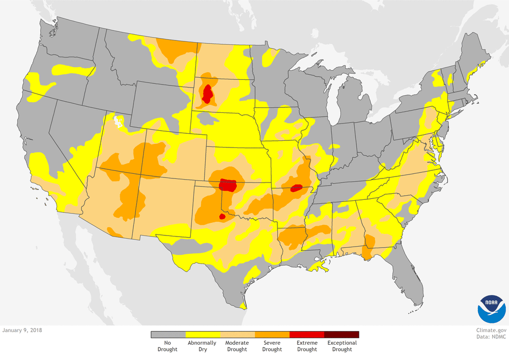
The changing of the seasons from winter to spring has brought an unwelcome worsening of drought across the U.S. Southwest and Southern Plains. This animated gif shows drought conditions becoming more intense and widespread between the start of the animation on January 9 and the final frame on April 17, 2018.
At the start of the year, only a few small areas of extreme drought existed in the contiguous United States, the largest of them in Oklahoma and South Dakota. As the season advanced, extreme drought conditions expanded from Oklahoma into Texas and Kansas, with detached pockets also appearing in Arizona and New Mexico by mid-February.
By mid-March, drought in the panhandle of Oklahoma had reached “exceptional” status, and severe drought had pushed northward from Arizona and New Mexico into Utah and Colorado. As of mid-April, parts of seven Southwest states had progressed into exceptional drought.
Drought impacts are piling up. Endangered fish in the Rio Grande had to be rescued and relocated to wetter stretches as parts of the river in New Mexico dried up. In Arizona and New Mexico, birds and elk have been observed coming to stock ponds and yards for water and food as natural sources of surface water and vegetation become scarce.
In Colorado, livestock operators are hauling water for cows and sheep as stock ponds and streams dry up, and farmers along the Middle Rio Grande in New Mexico have been told to expect half their normal irrigation allotment. Fire danger is extremely high for so early in the season, and burn bans are in place across many counties and forest service districts in multiple states.
You can find weekly drought maps along with drought outlooks in our Data Snapshots map collection. For details about drought conditions, visit http://Drought.gov.
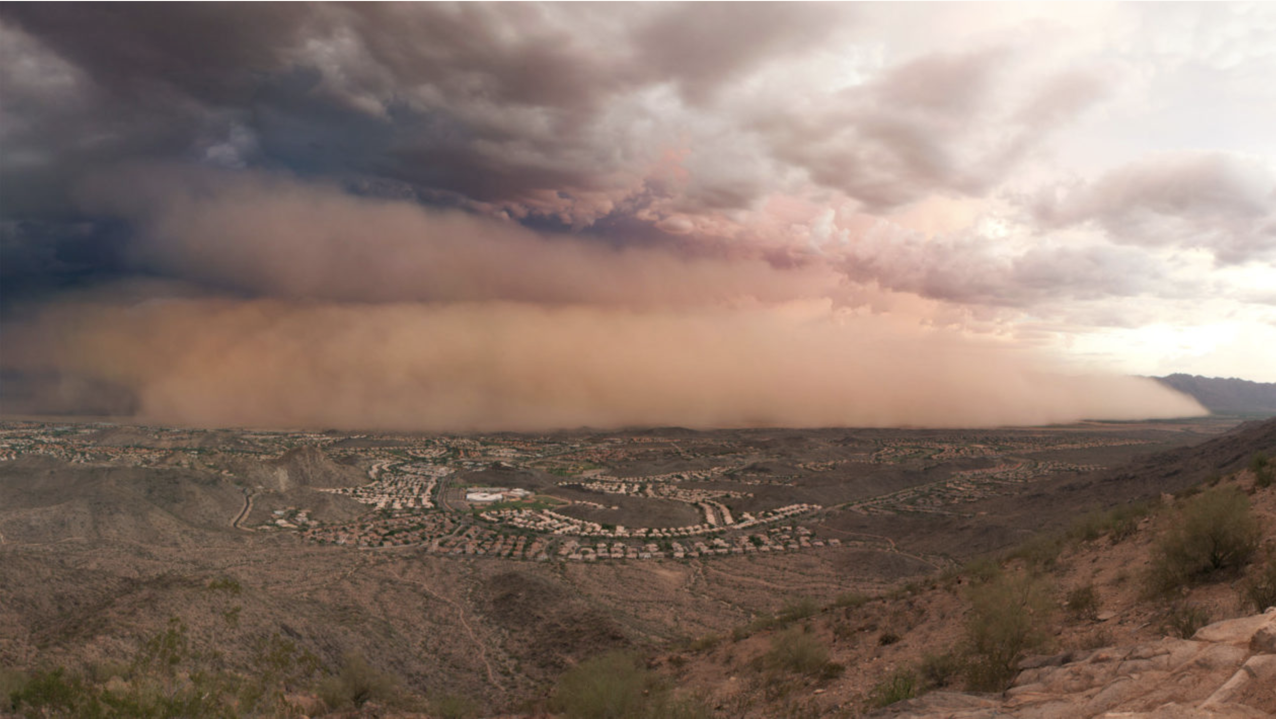
A dust storm approaches Phoenix. ALAN STARK/FLICKR and Yale Environment 360.
The arrival of northern Arizona’s windy spring season often brings the kind of dust storms Snider encountered. They can be a hazardous force, sometimes making it hard to see and breathe as they churn across the southern part of the Colorado Plateau. But they have an even broader impact when the dust settles on snowpack hundreds of miles away on the Rocky Mountains. There, the windblown particles create a darker coating on the snow that causes it to melt earlier and faster in the springtime and reduces the total amount of water that runs downstream.
Together those changes affect millions of people in Arizona and elsewhere in the Southwest who rely on rivers like the Colorado that are fed by Rocky Mountain snowmelt and are already stressed by the impacts of a warming climate.
This year’s dry fall and winter — the sixth driest on record in Flagstaff — have produced prime conditions for wind to whip up dust across the region. Vegetation that serves to anchor dryland soils against the wind is already showing signs of stress, with a good chance of low growth and production throughout the spring, said Seth Munson, a research ecologist with the U.S. Geological Survey.
DARKER SNOW
Just like the heat difference between an asphalt street and a light-colored concrete sidewalk in the summertime, snow coated with a layer of darker dust absorbs more sunlight and gets warmer than bright white, pristine powder. In the Colorado Rockies, that solar radiation, which gets amplified by dust particles, provides five to 10 times as much melt energy to snow as warming air temperatures in the springtime, said . A research paper Deems co-authored traced the downstream effects of dust on snow and found that during years of heavy dust loading, the Colorado River’s flows at Lees Ferry peaked three weeks earlier than low-dust years. It also found that earlier melting of dust-coated snow increased evapotranspiration and reduced total runoff into the Colorado by about 5 percent.
From a water resources perspective, the problem with snow disappearing faster and earlier in the season is the loss of the system’s most important reservoir, Deems said. Snowpack stores winter moisture that then melts slowly and feeds into river systems throughout the spring and summer, when it is most needed. When snow melts faster and earlier in the spring, it overwhelms the capacity of manmade reservoirs during a time when water demand is lower so the systems are forced to let it spill downstream unused, said Rich Reynolds, a scientist emeritus with the U.S. Geological Survey.
COLOR AND CRYSTALS
The bulk of the dust that causes the largest concerns about snowmelt in the Colorado River Basin comes from southern Utah, northern Arizona and northern New Mexico, Deems said.
The brown, red and orange hues that define these parts of the Colorado Plateau boost absorption of solar radiation more than light-colored dust that comes from areas like Nevada and parts of Utah, he said.
But it’s not just their darker color that make these particles particularly potent snow melters, said Reynolds, who studies atmospheric dust. The reddish-orange iron oxide minerals themselves have a heightened capacity to absorb solar radiation, Reynolds said. While more research needs to be done, Reynolds said the minerals’ crystal structure and their small size and large surface area play a role…
TRACKING DUST
The first noticeable increase in dust emissions, tracked through sediment cores collected from alpine lakes, were measured in the mid-1800s when railroads brought increased settlement and widespread grazing to the West, Deems said. Together, human development and livestock tore up native vegetation, introduced invasives and trampled biological soil crust that acts as a living armor, protecting desert soils from the elements, he said.
Levels of dust measured in the lake sediment cores jumped seven-fold over that period, Deems said. Dust loading then began to recede as several severe winters in the early 1900s killed large numbers of livestock and the Taylor Grazing Act of 1934 imposed regulations on livestock grazing.
But in at least the past decade or so, measurements show dust emissions are again on the rise, Deems said. While dispersed dust sources are difficult to capture, scientists can now use optical satellite imagery to track dust plumes as they crawl toward the mountains, he said.
Less than eight months after Hurricane Harvey pelted the Texas Gulf Coast with torrential rainfall, drought has returned to Texas and other parts of the West, Southwest and Southeast, rekindling old worries for residents who dealt with earlier waves of dry spells and once again forcing state governments to reckon with how to keep the water flowing.
Nearly a third of the continental United States was in drought as of April 10, more than three times the coverage of a year ago. And the specter of a drought-ridden summer has focused renewed urgency on state and local conservation efforts, some of which would fundamentally alter Americans’ behavior in how they use water.
In California, for example, officials are considering rules to permanently ban water-wasting actions such as hosing off sidewalks and driveways, washing a vehicle with a hose that doesn’t have a shut-off valve, and irrigating ornamental turf on public street medians. The regulations, awaiting a final decision by the California State Water Resources Control Board, were in force as temporary emergency measures during part of a devastating five-year drought but were lifted in 2017 after the drought subsided.
Water restrictions, either forced or voluntary, are nothing new to states and communities where battling drought is often a part of life. In Amarillo, Texas, the city’s water department stresses conservation with the message, “every drop counts,” and urges customers to do “at least one thing a day to save water.” A similar mantra — “squeeze every drop” — is part of the water-saving culture in Oklahoma City, where officials enforce mandatory lawn-watering restrictions and impose higher rates for excessive water use.
Years of studies by government and environmental groups have warned that future demand for water is threatening to outstrip availability, particularly in the drought-plagued West and Southwest, unless policymakers take steps to reverse those trends.
“More and more cities around the world are running into limits on how much water they have available to meet their needs,” said Peter Gleick, co-founder of the Oakland-based Pacific Institute and an expert on water and climate issues…
U.S. government and environmental experts generally agree that no major city is in imminent danger of the kind of scenario confronting Cape Town. But residents in some small communities have struggled, and at the same time, U.S. experts worry that protracted global warming, worsening droughts, vanishing groundwater and growing populations will erode future supplies and make Americans increasingly vulnerable throughout the 21st century…
The Environmental Protection Agency, in a January 2017 snapshot of the impact of climate change, predicted that the Southern Plains will face more “extreme heat” in the future, saying that the number of days of 100 degrees or hotter will quadruple by 2050.
“Increasing temperatures and more frequent and severe droughts,” the EPA said, “are expected to heighten competition for water resources for use in cities, agriculture and energy production.”
Adding to America’s water insecurity is a decadeslong decline in groundwater resources, which supply half of the nation’s residents and nearly all of its rural population, according to the U.S. Geological Survey.
Sustained groundwater pumping has steadily taken its toll on aquifers throughout the country, lowering groundwater levels by hundreds of feet in some places. Water levels in the High Plains aquifer system, which underlies parts of eight states, have dropped by more than 100 feet in places, largely as a result of extensive irrigation, according to the USGS.
Federal water managers will be facing difficult decisions as the worsening drought is significantly affecting flows on one of the country’s longest river systems and prompting rescue missions for a tiny endangered fish.
The U.S. Bureau of Reclamation and U.S. Army Corps of Engineers released their operating plan for the Rio Grande on Thursday.
With some of the lowest snowpack reports on record, officials said they will have little water this season as they decide when and how best to move what is stored in the reservoirs for downstream users and for the Rio Grande silvery minnow.
The tiny fish, listed as endangered in 1994, was once abundant throughout the Rio Grande Basin from Colorado to Texas and into Mexico. It’s now found only in a fraction of its historic habitat as the river system has seen dam building and the straightening of its once meandering channels over the last 150 years.
The minnow population just five years ago marked one of the lowest levels since surveys began in the mid-1990s. At that point, the fish was showing few signs of reproduction in the wild and that year’s fast-moving drought left biologists trying to salvage as many of the minnows from puddles in the drying river.
This year, water managers say more than 10 miles of the river have already dried in the area of Bosque del Apache National Wildlife Refuge, prompting the need for another intensive salvage effort.
Tom Sinclair, project leader with the U.S. Fish and Wildlife Service’s regional conservation office, said he and his team are finding a lot of minnows in the river since the last two years were favorable for the fish due more robust flows.
The rescue efforts began April 2, marking one of the earliest starts to salvage operations, Sinclair said…
Biologists have collected as many as 10,000 minnows on some days and many of the females appear ready to spawn. The fish are transported to wetter sections further upstream and released.
The Bureau of Reclamation is working with other agencies to coordinate river operations to ensure there’s a bump in spring flows for spawning and egg collection.
The salvage work is expected to continue as biologists get reports about more sections of the river going dry.
Water managers warned during a briefing Thursday that residents in the Albuquerque area — the state’s most populous region — should be prepared to see a dry riverbed later this spring and summer.
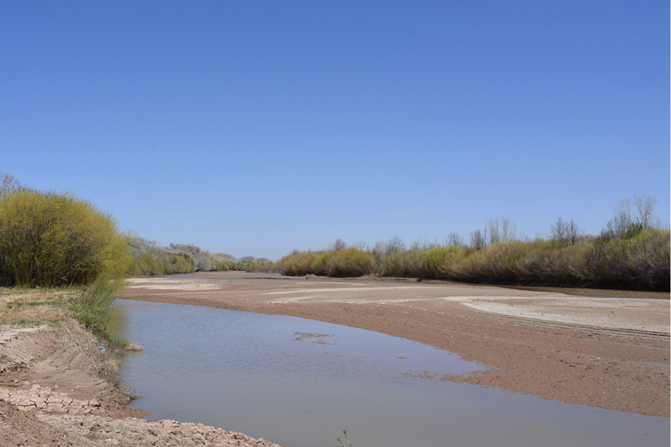
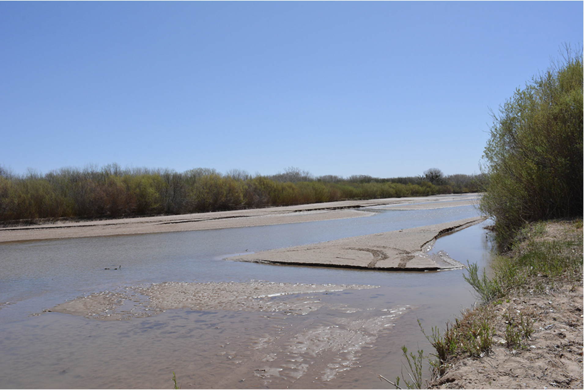
The drying riverbed of the Middle Rio Grande near the Bosque del Apache National Wildlife Refuge on April 4, 2018. Photo credit: USBR
From the U.S. Bureau of Reclamation (Mary Carlson):
In the face of a worsening drought, the Bureau of Reclamation’s Albuquerque Area Office and U.S. Army Corps of Engineers today released their Annual Operating Plan for the Rio Grande. Some of the lowest snowpack reports on record will leave water managers with very little water to manage and some difficult decisions on when and how to move water down the Rio Grande to benefit downstream water users and to implement a survival strategy for the Rio Grande silvery minnow, which is protected under the Endangered Species Act.
The April forecast data released by the Natural Resources Conservation Service shows the Jemez River Basin at 6 percent of average, the Chama River Basin at 18 percent of average, and the Upper Rio Grande at 50 percent of average. Inflow into Heron Reservoir is estimated to be approximately 30,000 acre-feet. This, combined with the previous allocation of 55,000, should bring San Juan-Chama Contractors close to a full allocation this year. El Vado Reservoir is projected to have an inflow of about 41,000 acre-feet and could be nearly empty by July.
Reclamation has about 11,600 acre-feet of water available to supplement flows through the Middle Rio Grande and is currently releasing about 200 acre-feet. More than 10 miles have already dried in the Bosque del Apache area. Reclamation is working closely with its partners and is focused on implementing a survival strategy for the Rio Grande silvery minnow as outlined in the 2016 Middle Rio Grande Biological Opinion. Reclamation is coordinating with Interior’s U.S. Fish and Wildlife Service to ensure fish rescue crews are active in the areas of the river that have dried. We are also working with the Middle Rio Grande Conservancy District, Albuquerque Water Utility Authority, and other stakeholders on an operational pulse to facilitate silvery minnow egg collection efforts.
On the Rio Grande Project in southern New Mexico, the allocation to the two irrigation districts and Mexico is about 60 percent of a full allocation. Both irrigation districts had some carryover water in storage from last year. Little inflow is expected to Elephant Butte Reservoir this spring, and it could be left holding less than 5 percent of its capacity at the end of the irrigation season.
The drying riverbed of the Middle Rio Grande near the Bosque del Apache National Wildlife Refuge on April 4, 2018. Photo credit: USBRReclamation operates pumps to move water from the Low Flow Conveyance Channel into the Rio Grande. The LFCC acts as a drain for the lower part of the Middle Rio Grande. Photo credit: USBR
This year, across much of the West, particularly the Southwest, there’s little in the way of abundance. At Lake Powell, the second-largest reservoir in the West, runoff is predicted to be only 43 percent of average. Arizona is looking at one of its lowest runoff years in history. And in New Mexico, stretches of the Rio Grande have already run dry, months ahead of normal.
The only consolation is that last year was a wet year and reservoirs received a boost. While it’s typical in the West to have big swings in precipitation from year to year, what has concerned scientists lately is that even good years are no longer producing the kind of runoff seen historically.
It’s even prompted a group of scientists with the Colorado River Research Group to call for a new language to describe the conditions they’re seeing.
“There’s lots of talk of drought but there’s not enough talk that this is likely the new normal,” said Brad Udall, a member of the group and a senior water and climate research scientist at Colorado State University. “We really need to think in the long term that we are actually going to see less water in the [Colorado River] basin and we’re never going back to the 20th century.”
And in the Southwest, this “new normal” may look more like “aridification” than drought.
In a recent white paper from the Colorado River Research Group, scientists write that while drought may be occurring, it doesn’t give the full picture. “For that, perhaps the best available term is aridification, which describes a period of transition to an increasingly water-scarce environment – an evolving new baseline around which future extreme events (droughts and floods) will occur.”
Since the turn of the 21st century, the Colorado River basin has been experiencing drought conditions. Bad water years have taken a toll on the system and good years haven’t aided the recovery enough. “We’ve had [fewer of] the normal big years; those are the years that refill our reservoirs and those seem to have gone away or at least now they are less frequent and they seem to be smaller,” said Udall.
Drought, he added, implies something temporary. “And we don’t think this is in fact temporary.”
And that’s because it’s not just about the amount of precipitation. In the past few years, studies have also shown a decline in “runoff efficiency” – or how much water actually makes it to rivers.
One of the biggest reasons is temperature.
“In large part, the answer is that the basin has become hotter, which modifies several facets of the hydrologic cycle that lie between precipitation and runoff, including evapotranspiration and sublimation rates, the timing of snowmelt and soil moisture characteristics,” according to the paper.
Research published last year by Udall and Jonathan Overpeck found that flows declined on the Colorado River by 19 percent between 2000 and 2014 and on average one-third of that falloff was due to rising temperatures.
The science is clear on increasing temperatures in the region, but how much changes in precipitation affect long-term trends remains to be seen. The basin could experience more precipitation with climate change, or bigger swings between wet and dry years or possibly even longer, more severe “megadroughts.” “You can have aridification under climate change even if precipitation stays the same or goes up,” Udall said.
The Colorado River basin is not the only area impacted by this scenario – the Rio Grande basin is in a similar situation, said David Gutzler, a professor of Earth and planetary sciences at the University of New Mexico. “As the climate warms up, now what we see is even when there is a pretty good snowpack, like we had last year, we don’t get enough snowmelt runoff to make a huge impact on [Elephant Butte] reservoir,” which is the main area of storage for the Upper Rio Grande.
Gutzler coauthored a recent study looking at changes in streamflow volume and temperature in the Upper Rio Grande watershed near the river’s southern Colorado headwaters from 1958 to 2015. The study found that, on average, temperatures during winter and spring had increased during the study period and the amount of the snow-water equivalent (or the water in the snowpack) decreased by 25 percent. There was a small decline in streamflow as well, despite a small increase in precipitation on average.
The findings are consistent with previous studies showing that warming is already impacting the West, with a shift to earlier spring snowmelt and more precipitation falling as rain instead of snow.
“We’re seeing the climate change signal of warming temperatures most strongly in the spring season here,” said Gutzler. “That makes these low-flow conditions that we see right now potentially even worse.”
With warmer temperatures, what snow there is melts earlier, and evaporation rates go up, reducing water supply even more. “It’s part of the tendency toward aridity that we’re experiencing in the West,” said Gutzler, which presents a big management challenge.
That doesn’t necessarily mean that a crisis is in store, but a change in the way rivers are managed may be. “We should be able to work out a way to deal with 20 percent less water in a way that doesn’t harm the economy, that doesn’t harm the environment, and if you do it right, it causes minimal harm to agriculture,” said Udall.
The solutions don’t just involve talking about water management, but also reducing greenhouse gas emissions. “There is this total political hang-up on having the discussions we need to have on greenhouse gas emissions,” Udall said. “This is so important and yet we somehow have managed to think we can ignore it – even well-meaning people think they can ignore it and it’s just not the case. We have to, as individuals and states and municipalities, begin to grapple with how to get greenhouse gas emissions down as fast as we can.”
“If you look at the overall flow of the Colorado River – at Lake Powell, the main measurement point for the entire Colorado River Basin, it’s less than half of normal,” said [John] Fleck.
That low flow impacts cities, agriculture and Western ecosystems for the rest of the year, if not longer. Already the Rio Grande River is so low that researchers are rescuing stranded fish by carrying them to wetter parts of the river. In California, instead of snow, the state experienced record-breaking wildfires and floods. Throughout most of the winter rainy season the state looked like it was headed for another devastating drought after only one year of relief.
“But then, March came along, and we actually got quite a lot of precipitation,” said Lohan. “Even with the snowpack tripling in March, it ended up being just over 50 percent of normal. So, it ended up being, not a catastrophic year, but definitely not a great year either. “
Fleck said that this was “maybe the sixth worst year that we’ve had in the last century” in the Colorado River basin. Coming in sixth might not seem too bad, but the bigger picture is that the number of droughts has dramatically increased, according Fleck. Climate change has created a “new normal” in the West, where the term “drought” may not even apply.
“It implies that the situation we’re in is abnormal. Clearly, it’s not,” said Fleck, “it’s a permanent state of affairs.”
It’s serious, folks. The drought conditions for Archuleta County are tipping into the farthest part of the scale at “exceptional.” We are surpassing the conditions we faced in 2002 and 2012.
What does that mean for us? We are primed for a disastrous wildfire season, we will have less water in our reservoirs and we will see higher prices at the grocery store because of crop failures. We are already saw winter crop failure in the Cortez area, and the Front Range is reporting crop failure predictions.
March typically begins the ramp up of spring precipitation to help kick-start the growing season. But for many areas of southern Colorado, precipitation was less than 20 percent of average. As we continue toward summer, these deficits become harder to make up. Around the Four Corners and down into the higher elevations of New Mexico and Arizona, the water year total deficits range from 4 to 9 inches — amounts that are unlikely to be made up prior to the start of the monsoon season (Colorado Climate Center).
Drought is something that affects us all. The environmental and economic impacts will touch everyone who lives and visits our area.
What can you do to help alleviate the effects? Watch your water consumption. Even though we want to keep our beautiful landscapes alive, please consider using high-drought-tolerance plants. Or, better yet, skip the landscaping plans all together. If you do have landscape that you have to water, use mulch to keep the soil moist, cool and protected from wind. Keep an eye on the weather and don’t water when Mother Nature takes a turn.
Snowpack in the Colorado River watershed is already at record lows as we move into the longer and drier days of summer. Water managers and fire forecasters are sounding the alarm about less water flowing in streams and reservoirs. Dust adds one more layer of complexity to an already precarious year.
To see it you need to dig a pit. In the spring, that’s usually where you’ll find Jeff Derry, waist deep in a snow pit somewhere in the southern Rocky Mountains. His job as the director of the Center for Snow and Avalanche Studies in Silverton, Colorado, forces him to pay close attention to the amount of dust that winds up embedded in snow.
Think of it like the rings of a tree. If you dig deep enough, you see the entire winter’s story, made up of layers of snow, reminders of each storm that’s built the snowpack. But when Derry digs pits it’s not just so he can get nostalgic for snow storms of yore. He’s on a fact-finding mission.
“I’ll be curious if you’re going to be able to see the dust event we had February 18 and 19,” Derry says as he shovels snow over the edge of the pit. “Because it is very subtle.”
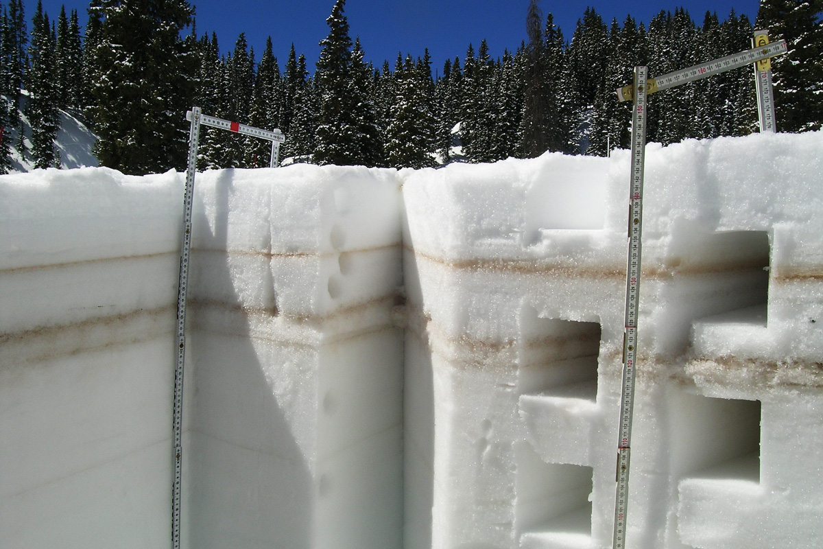
Layers of dust stripe the sides of a pit dug into the snow in Colorado. Dust deposited or exposed on the surface of the snowpack contributes to faster warming and melting. Center for Snow and Avalanche Studies
There are a range of instruments to measure every aspect of snowpack. They’re fine-tuned for temperature, density and reflectivity. Water managers, farmers and cities are always curious about the amount of water held in snow, which gives a glimpse into what the spring runoff will bring. But the best way to gauge the magnitude of a dust layer is with the human eye, Derry says.
“It’s very qualitative in a sense,” he says. “You go out, you look for it, you dig, you see what you see.”
Derry takes his hand, brushes off the cross-sectioned snowpack, and there it is. About seven inches down is a beige-colored band of dust.
This tiny little strip of dust has the potential to upend how we manage water in the West, Derry says. Eventually this snow will melt and empty into the Colorado River, via the Uncompahgre and the Gunnison. The watershed provides water for some 40 million people in the southwest.
The dust, just by showing up, can speed up spring runoff, causing streams to peak weeks earlier and make melting more intense and erratic.
When there’s no dust on the snow, it’s brilliantly white. On a sunny day it’s reflective enough to cause eye damage. Snow has a high albedo, a measurement of reflectivity. Unadulterated snow is the most reflective surface found in nature. Without dirt or dust snow melts off slow and steady like the drumbeat of a drip from a faucet.
This is what water managers love. It’s predictable. But when you add in dust, the snow gets darker, like it’s wearing a black T-shirt, and it absorbs more sunlight…
Back in the San Juan mountains, dust detective and snow scientist Jeff Derry says he’s bracing for more dust events this spring. The mountain range has registered five dust events since October. Derry says the San Juans are ground zero for this problem. And because they’re a key part of an already overtaxed Colorado River system, he says everyone in the seven U.S. states and in Mexico that depend on the river should be concerned.
“We’re located at the headwaters of four major watersheds,” Derry says. “And our mountain systems are undergoing change at a fundamental level.”
Change that could make the West an increasingly dry — and dusty — place.
This story is part of a project covering the Colorado River, produced by KUNC and supported through a Walton Family Foundation grant. KUNC is solely responsible for its editorial content.
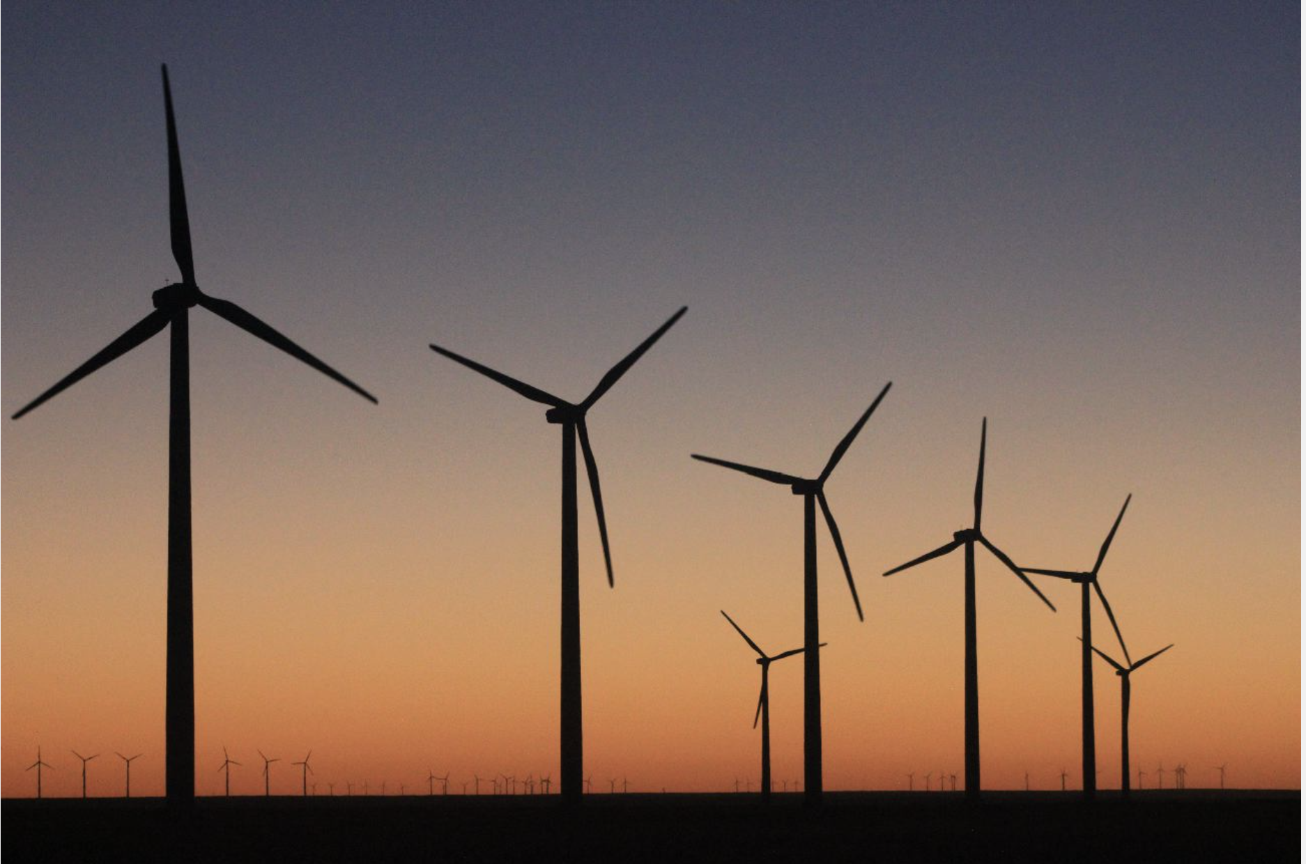
Even though new U.S. wind power installations were down in 2017, wind energy is expected to pass hydro as the nation’s top renewable energy source this year.
A new report underscores that even as Republican leaders remain resistant or even hostile to action on climate change, their states and districts are adopting renewable energy at some of the fastest rates in the country.
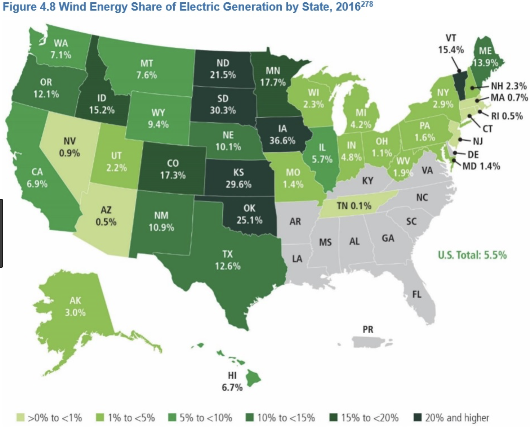
Four states—Iowa, Kansas, Oklahoma and South Dakota—now get more than 30 percent of their in-state electricity production from wind, according a new report by the American Wind Energy Association…
While the U.S. wind power industry continued to expand last year, however, its growth rate slowed, with 7 gigawatts of capacity added in 2017, down from more than 8 gigawatts added in 2016.
The slower growth likely was due in part to changes in tax credits. Developers could take full advantage of the federal Renewable Energy Production Tax Credit for wind energy through the end of 2016, but it began phasing down starting in 2017. And the governor of Oklahoma, the state with the second-highest wind power capacity, signed legislation in 2017 to end state tax incentives for the industry three years early amid a budget crisis…
But the total slice of renewables—which provide about 17 percent of the nation’s electricity—is far short of the energy transition experts say is needed to avoid dangerous warming. A paper last year by some of the world’s leading climate change experts said renewables need to make up 30 percent of the global electricity supply by 2020 in order to meet the goals of the Paris climate agreement.