On Tuesday, April 24, 2018, Gov. John Hickenlooper signed the Mussel-Free Colorado Act into law in a short ceremony at the Colorado State Capitol Building in Denver. The new law provides a stable funding source of $2.4 million for Colorado Parks and Wildlife’s Aquatic Nuisance Species Program for 2019 and beyond.
In February, the House passed the bill 44 – 20. The bill passed the Senate 24 – 10 in March.
“This is a huge win for protecting Colorado’s water,” said CPW Director Bob Broscheid. “Stable funding for the ANS program means a stable future for Colorado.”
The law requires Colorado residents to purchase a $25 ANS stamp for their boat. Non-residents must purchase a $50 stamp. The new law also:
Continues Tier 2 Severance Tax appropriations, when available, to cover the remainder of the $4.5 – $5 million annual cost of ANS program implementation
Increases fines for ANS-related violations. The fine for unlawful boat launches without inspection will be raised from $50 to $100. The fine for knowing importation of ANS into the state will be raised from $150 to $500 for a first offense.
Allows CPW to charge labor/costs incurred to store and decontaminate intercepted vessels.
Encourages federal partners to take responsibility for ANS inspection funding at their reservoirs.
Why do we need a mussel-free Colorado?
Zebra and quagga mussels are not native to the nation’s rivers, lakes and reservoirs and are considered our most serious invasive species threat. Adult infestations harm aquatic ecosystems and fisheries by disrupting the food web and outcompeting native species. They cause enormous problems for water infrastructure used for municipal, agriculture and industrial purposes by attaching to, clogging and impairing water storage, treatment and distribution systems.
Eradicating an adult mussel infestation in an open water body is nearly impossible. Controlling infestations becomes a permanent and expensive part of normal operations post invasion. Colorado has implemented an effective prevention program to stop mussel introduction by inspecting and decontaminating watercraft before they enter our waters and ensuring that users clean, drain and dry their own watercraft in between each use.
Almost all the states east of Colorado have a zebra or quagga mussel infestation. A mandatory watercraft inspection and decontamination program, coupled with monitoring and education, is the best approach to keep Colorado free of the invasive mussels and other ANS.
In 2017, Colorado inspectors intercepted 26 boats infested with adult mussels coming in from out of state – a new record. Colorado has intercepted more than 145 boats infested with adult mussels since the ANS Program began in 2008. The number of infested boats increase each year and there have already been six infested boats intercepted in 2018.
Colorado’s ANS Program was in Jeopardy
The Colorado ANS Program was authorized by the Colorado Legislature in 2008 utilizing severance tax funds. CPW has leveraged those funds with federal and local grants to fund the ANS Program since inception. However, severance tax is a fluctuating source and federal funds have been reduced in recent years. The Mussel-Free Colorado Act is essential to providing a stable base of funding for the ANS Program to be leveraged with other dollars for the continued protection of water infrastructure, natural resources and maintaining recreational access to lakes and reservoirs. This funding source is critical to protecting our waters and water infrastructure from irreversible invasion.
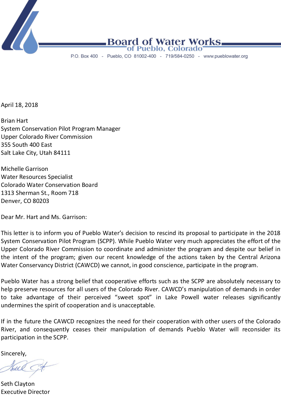
Pueblo Water’s decision comes after four states and Denver’s municipal water agency accused the Arizona agency — the Central Arizona Water Conservation District — of undermining Lake Powell elevations by manipulating the complicated supply-and-demand rules that govern water orders.
“Given our recent knowledge of the actions taken by [CAWCD] we cannot, in good conscience, participate in the program,” Seth Clayton, Pueblo Water’s executive director, wrote in the letter.
The letter, dated April 18, comes as the Arizona agency is set to meet next week with negotiators for the Upper Basin states of Colorado, New Mexico, Utah and Wyoming. The Colorado River is split into two basins with two main reservoirs. The Upper Basin stores water in Lake Powell and the Lower Basin stores water in Lake Mead, 30 miles outside of Las Vegas.
The Arizona agency at the center of the controversy, CAWCD, has kept quiet in recent days, despite increasing media attention, so as not to affect the outcome of those discussions.
The Lower Basin states of Arizona, California and Nevada are also scheduled to meet on May 2, although that meeting had been scheduled before the letters to CAWCD were reported last week. The commissioner for the Bureau of Reclamation had been invited to that meeting.
The Pueblo letter confirms what Upper Basin water managers feared — that Arizona’s actions would dissuade water users from joining the conservation program. The program, which is in its pilot phase, pays water users to conserve. The hope is that the conserved water, by not leaving the system, will boost the elevation of Lake Powell. The Arizona agency has said it wants to maximize the amount of water it gets from the Upper Basin, which stores water in Lake Powell.
“[Upper Basin water users] do not want to be putting water into Lake Powell if it gets immediately pulled down to feed this policy that the district is trying to advance,” said James Eklund, who represents the state of Colorado on the Upper Colorado River Commission.
CAWCD has said its strategy is to help Arizona prepare for shortage, noting that its actions are permissible under current Colorado River rules. In a statement last week, a spokesperson said: “We have been reaching out to our partners in the Upper Basin, hoping to clarify apparent misunderstandings, and to facilitate in-person, collaborative discussions aimed at finding solutions that will benefit the communities and environment served by this mighty river.”
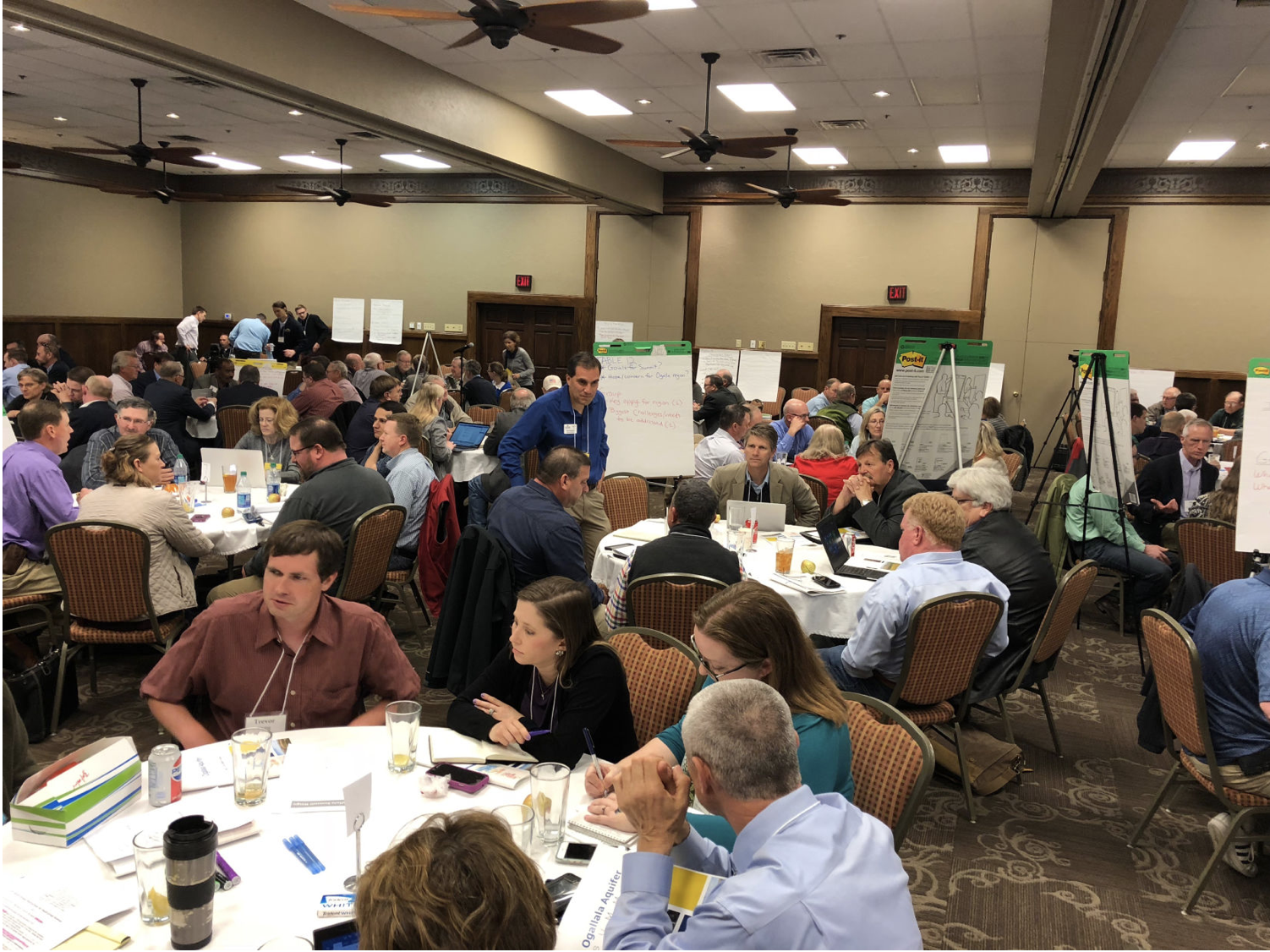
The inaugural Ogallala Aquifer Summit was April 9 and 10. Its goal was to bring together agricultural, municipal, research and industry stakeholders in one room to look at the realities of the aquifer today and create solutions to work toward conserving this vast resource for the future.
The summit was a product of the state of Kansas’s 50-Year Water Vision Plan, created in 2013. It recognized that the Ogallala Aquifer’s future not only directly affects Kansas, but also neighboring states and that any conservation efforts would need to be multi-state.
“People are impacted in all eight states by the aquifer,” explained Kansas Lt. Gov. Tracey Mann in his welcome. “The Ogallala Aquifer is the source of water for one-third of our state, and 44.5 percent of our economy is tied to agriculture. We have 3.5 million irrigated acres in Kansas, and 1.4 million of those are irrigated through the Ogallala Aquifer.”
[…]
John Stulp, special counsel to the Governor of Colorado on water, and a former Commissioner of Agriculture of Colorado, farms in eastern Colorado and understands firsthand the importance of the Ogallala Aquifer to agriculture…
Attendees at the first Ogallala Aquifer Summit, April 9 and 10, Garden City, Kansas, were broken into diversified focus groups by the organizers to better hash out issues that affect all eight states that sit above the aquifer. (Journal photo by Jennifer M. Latzke.)
“We have 12 million irrigated crop acres over the Ogallala Aquifer,” Stulp said. “About $12 billion of revenue is created out of this asset that we sit on top of here.”
Robert Mace, associate director and the chief water policy officer at the Meadows Center for Water and the Environment, laid out the history and the current status of the Ogallala Aquifer for participants.
Large irrigated region
Today, about 43,000-acre feet of water is pumped each day from the Ogallala Aquifer across the High Plains. It accounts for the largest area of irrigated cropland in the world and is 31 percent of the total irrigated land in the U.S., Mace said.
“We have seen more than 150 feet of decline in parts of Texas,” Mace said. While there are some parts that are rising, overall the saturated thickness of the aquifer has declined. In some areas of Texas, that’s more than 50 percent of the aquifer now depleted.
Over the two-day summit, participants shared information about scientific research into the status of the aquifer, the politics of the eight states above the aquifer, and measures that can be taken to extend its life.
Producers look to innovate
Darren Buck farms on the border between Kansas and Oklahoma, and he is staring at the end of the useful life of the aquifer under his farm ground. To extend the life of his wells to the next generation and beyond, he’s switched to no-till and strip-till farming, which helps him conserve as many drops of 17 inches of annual rainfall as is possible.
“We also have telemetry on our center pivots,” he said. This allows him to be able to stop and change the speed and direction of his pivots. By monitoring his pivots remotely he can catch wasteful situations quicker, thus preserving the water he’s pumping.
“On one of my pivots, I can apply an amount of water comparable to two days water supply for a town of 2,000 people,” Buck said. “One pivot, over 10 hours.”
Additionally Buck practices track management, which sounds simple but can save a lot of water when properly applied in clay loam soils like his.
“We run our pivots routinely 1,500 or more hours a year, and we get tracks,” he said. “At the end of the season, the evapotranspiration need of the corn starts to tail off, so the need for water on the corn goes down. But, if you get a rain shower, you don’t let the pivots stop because they’ll get stuck if you shut them down. And if you need them in a hot and dry snap to help corn fill properly to the end of the season, it could be a problem. That’s why you see pivots running when it’s raining.” Being able to shut down the water and start back up again saves a lot of water.
Summits help, official says
Jim Butler, of the Kansas Geological Survey, brought home the importance of summits like this. The survey has new modeling framework that accounts for the water levels of the aquifer and the water use data from the wells on it to answer the question of how much do we need to reduce pumping on the aquifer to keep it at current levels?
The survey found that on the far western third of Kansas, directly over the bulk of the aquifer, pumping would have to reduce by 27 to 32 percent to keep the aquifer at current levels.
“If you want to reduce the rate of decline by half, then you take those numbers and divide by two and see that a relatively modest reduction in pumping could have a large impact on the decline rate,” Butler said.
Regulating the aquifer through state statutes and policies can be tricky because each state deals with individual water rights by judicial precedence and politics that go back a 100 years or more. Organizers said that was one major reason it’s critical to have summits like this regularly to get stakeholders actively involved in solving problems and sharing knowledge.
Meeting helps citizens, officials from eight states to share ideas and concerns
More than 200 people from agriculture and other industries came together April 9-10 to discuss the challenges and opportunities for preserving groundwater in the Ogallala Aquifer region, a large resource that touches parts of eight states from South Dakota to Texas.
The Ogallala Aquifer Summit marked a key accomplishment in the 50-year water vision for Kansas, a plan set forth in 2013 by then Kansas Gov. Sam Brownback.
“The Ogallala was one of the two marquee parts of the governor’s 50-Year Water Vision, along with the reservoirs in the eastern part of the state,” said Tracy Streeter, director of the Kansas Water Office, which organized the summit along with Kansas State University and Colorado State University.
“This conference is very important in helping us achieve our goals under the 50-year water plan that the governor set us on three years ago.”
Dan Devlin, the director of the Kansas Water Research Institute at Kansas State University, noted that the meeting was also in response to citizen’s requests.
“It was really interesting back when Gov. Brownback was doing the meetings for the 50-Year Water Vision for Kansas, we heard at meeting after meeting from citizens that they wanted to talk to the other Ogallala states,” Devlin said. “They said, ‘we want to know what they’re doing. We want to know what we can learn from them and we can also share things.’”
The Ogallala Aquifer underlies 175,000 square miles, or about 112 million acres in parts of eight states. For nearly 80 years, farmers and communities have been using the aquifer for agriculture and public water supplies. The Ogallala supports about 30 percent of all U.S. crop and livestock production, accounting for an estimated $35 billion in agricultural products annually.
But the resource is dwindling…quickly. Southern parts of the aquifer – including many areas of Texas and New Mexico – are nearly dry and in western Kansas, an extremely productive agricultural region, wells are slowing down as the amount of water available to farmers is becoming increasingly scarce.
“When we are dealing with issues like the Ogallala Aquifer, addressing them from one state’s perspective is just not the best way to get something done,” said Jackie McClaskey, secretary of the Kansas Department of Agriculture, who participated in the two-day meeting.
“By pulling together all of the states impacted by the Ogallala it allows us to bring lots of great ideas and lots of minds and lots of folks together to really say how can we work together to address concerns in the Ogallala, whether that be decline or economic conditions surrounding the Ogallala…all the different types of issues that not only Kansans are concerned about, but all of the folks that live on the Ogallala.”
Summit participants heard presentations on science and research, technology, producer practices and water policy, and shared their views on each during small group sessions. Their opinions were compiled and will be part of a report due out later this year.
“For me, the importance of this meeting is just kind of listening to some of the concerns in the other states,” said Harold Grall, a farmer near Dumas, Texas. “We’re all pumping out of the same aquifer. Each of the states has its own set of rules and regulations on how they conserve water and I like hearing those different ideas.”
He added: “At times, it just seems because we’re depleting a finite source, that our time is limited, but talking to the people around here helps us to be hopeful that maybe we’ve got a longer time than we think.”
A common theme at the meeting was that farmers want to do what’s right and sustain the resource for generations to come. It wasn’t a message lost on 16-year-old Grace Roth, an officer in FFA and a Kansas Youth Water Advocate.
“It encourages me and also makes me feel kind of relieved because these people have a genuine care for the future and these people want to do something for our generation,” Roth said. “They want to take action today so that we can ensure our future; we can ensure the future not only of agriculture but also the future of our world.”
Roth, who gave an impassioned 10-minute talk during the meeting, said every person should be interested about issues that help to preserve and protect water.
“Just imagine if one day you turn on your sink and nothing came out,” she said. “How would you continue on with your life? It’s a very scary thought of not being able to prosper in the future.”
Much of the university research currently being conducted in the Ogallala Aquifer region is a result of a Coordinated Agriculture Project (CAP) grant from the National Institute of Food and Agriculture. CAP grants are designed to involve researchers from many universities and organizations, and to communicate information to citizens.
“We want producers to be the voice that is spreading the message,” said the Kansas Water Office’s Streeter. “It’s one thing for ag departments, universities, water office folks to get up and tell these success stories, but it’s much better for the producers themselves to do it, and that voice does get heard by other producers.”
McClaskey added: “What I think is unique about (the Ogallala Summit) is that we have universities engaged, we have government agencies engaged, but most important we have farmers and ranchers engaged. And those are the folks that are going to hold the rest of us accountable to keep moving forward and make sure that progress happens.”
Here’s the update from the CWCB/DNR (Taryn Finnesey/Tracy Kosloff):
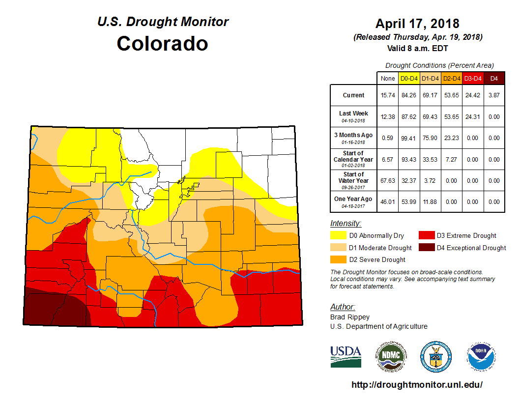
Exceptional drought has been introduced into the four corners region of Colorado as persistent precipitation deficits continue. While early April storms have helped improve conditions throughout northern Colorado, the southern half of the state remains extremely dry. Conditions are somewhat tempered by strong reservoir storage, but water providers are already seeing increased demands and implementing restrictions. Agriculture is also seeing loss of winter wheat and strong winds have fueled early fires. Water year-to-date accumulation at Mesa Verde is the lowest in its 95 year record.
As of April 19, exceptional drought has been introduced in southwest Colorado, covering 4 percent of the four corners region, primarily in Montezuma and La Plata County. Extreme drought, D3, covers 21 percent of the state; severe drought 29 percent and 16 percent is classified as moderate drought. An additional 15 percent of the state is currently experiencing abnormally dry conditions (see image on reverse side).
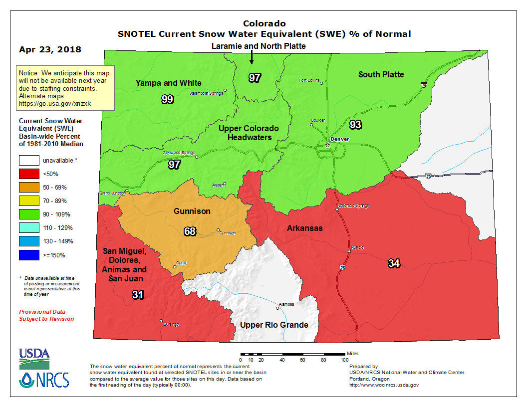
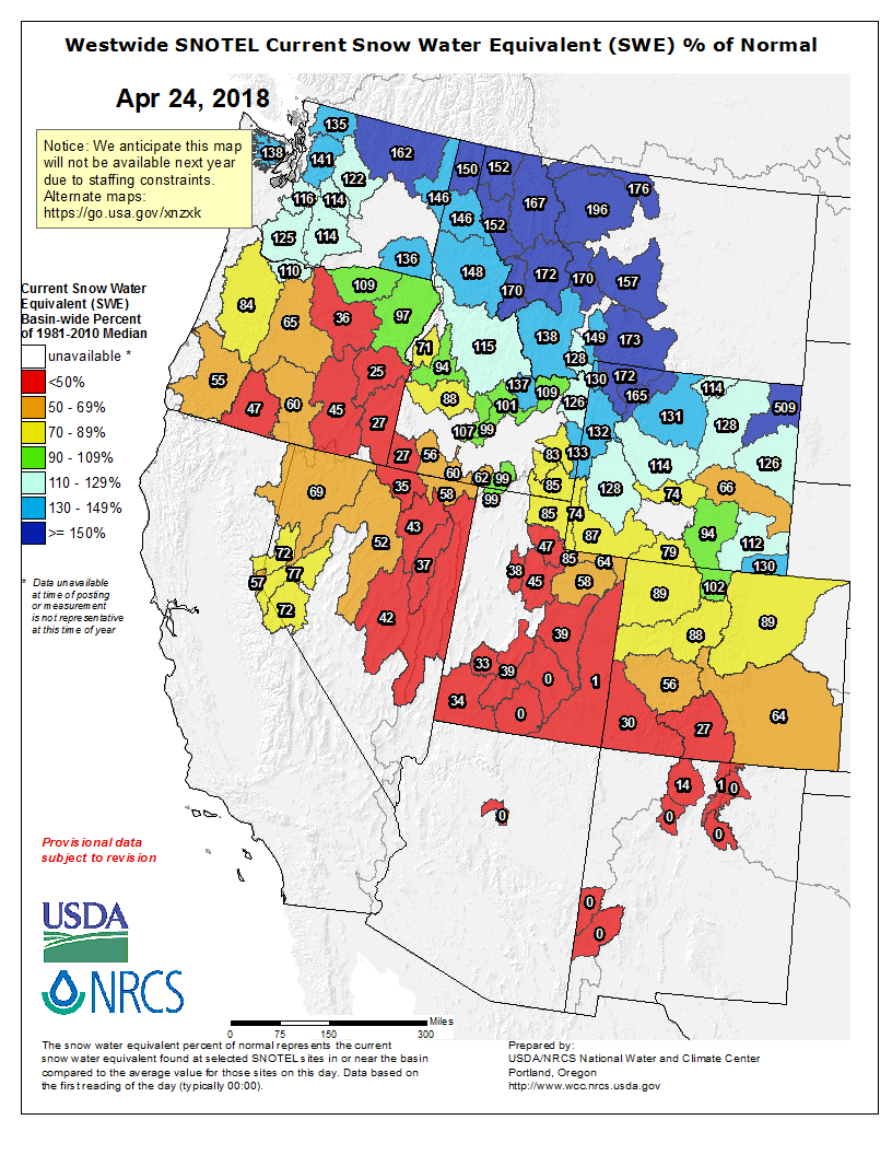
As of April 19, statewide snowpack at SNOTEL sites is 69 percent of average. However, there is a stark contrast between conditions in the southern half of the state and the northern half. The Gunnison basin has the lowest snowpack on record while the Southwest basins and Rio Grande have already achieved their peak snowpack and have now seen a 50 percent melt off of their snowpack.
Many southern basins’ year –to-date precipitation, based on SNOTEL is tracking near 2002; while other sites have the lowest in the nearly 40 year record (see image on reverse side).
Reservoir storage statewide is at 114 percent of normal, with all basins above average. The Arkansas basin is reporting the highest average storage at 131 percent. The Southwest basins of the San Miguel, Dolores, Animas & San Juan have the lowest storage levels in the state at 101 percent of normal. While still above average, storage levels have begun to decline from previous months.
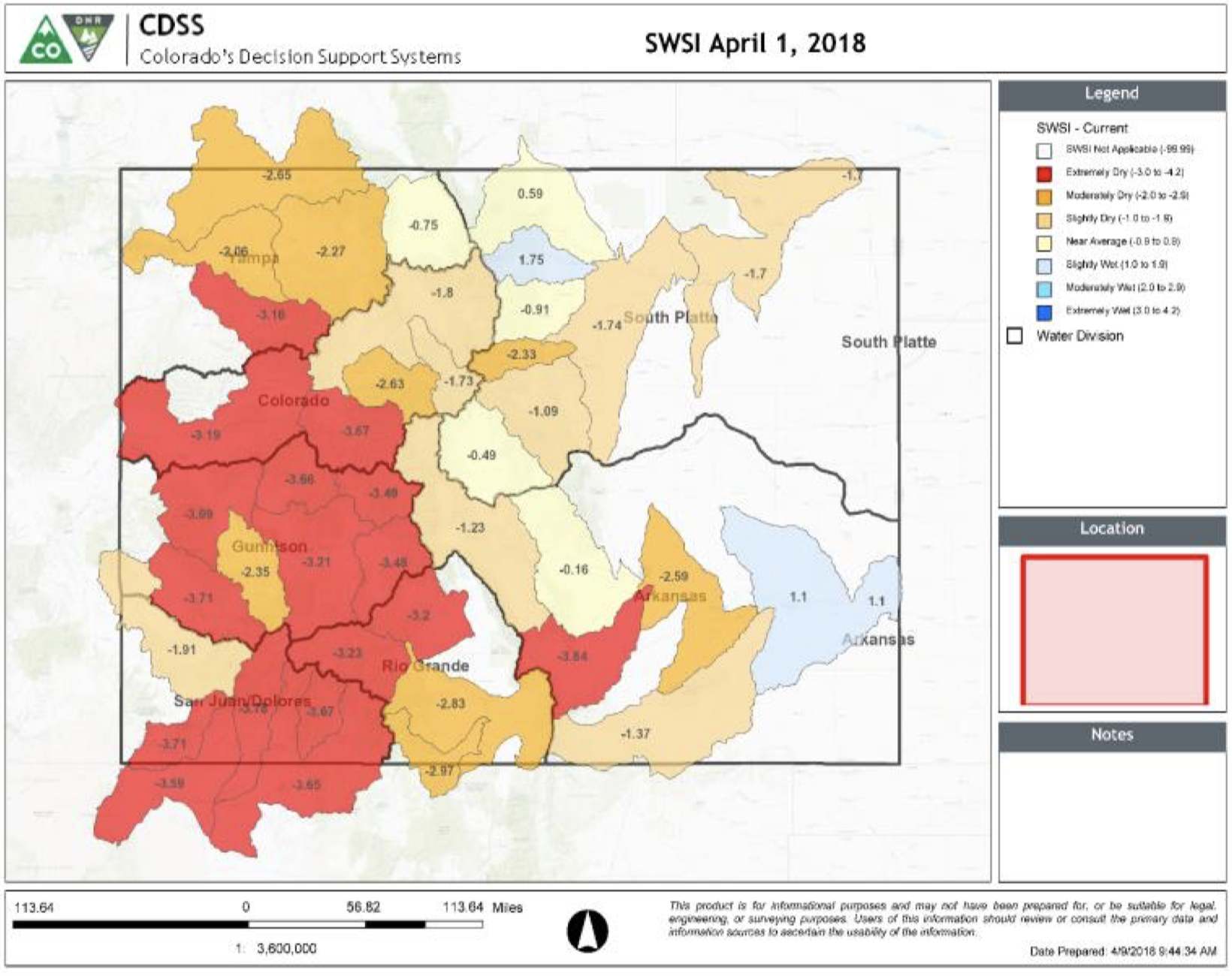
The Surface Water Supply Index (SWSI) values have declined for April 1, with much of the western slope classified as extremely dry. These values are largely driven by below average streamflow forecasts. The sub- basins with the highest values are a result of large reservoirs such as Lake Granby and John Martin Reservoir (See image on reverse side).
Streamflow forecasts are well below average for the vast majority of the state with the South Platte the only basin with any near normal projections. The southern half of the state continues to see declines, and the southwest corner has streamflow forecasts below 50 percent of average.
Longterm forecasts indicate below average precipitation into May coupled with increased likelihood of above average temperatures.
Statewide snowpack basin-filled map April 23, 2018 via the NRCS. Note Rio Grande did not render correctly. It was at 31% of normal on April 22, 2018.
Statewide SNOTEL water year-to-date precipitation is below average across much of the state but particularly in the south with some sites in the San Miguel, Dolores, Animas and San Juan Basins recording all time lows.
Colorado Drought Monitor April 17, 2018.
Southern Colorado has continued to see an expansion of drought conditions through the snow accumulation season, with exceptional conditions now present in Montezuma and La Plata counties.
April 1 Surface Water Supply Index values are well below normal for the western half of the state, with the driest regions in the four corners area.
Despite subpar snow accumulation in the heart of winter 2017/18, the snowpack in the mountains near Steamboat Springs — and with it, the water supply that refresh the river — has continued deeper into the spring than is normal.
Karl Wetlaufer, a hydrologist with the Natural Resources Conservation Service told Steamboat Today in May 2017 that snowpack typically peaks in this region April 10. The good news for irrigators and paddlers is that the snowpack has continued to build into April 2018.
Improbably, the meager snowpack that accumulated in January and February has been compensated for by heavy spring snow at elevations above 9,000 feet. And that bodes well for filling reservoirs and fueling kayak play parks.
The Yampa peaked at 2,640 cfs in 2017.
The view of the upper Yampa Valley from the west side of Rabbit Ears Pass this week belies the amount of water yet to flow from the southern end of the Park Range and feed spring runoff in the Yampa River.
From a pullout on U.S. Highway 40, it was plain to see April 21 that the valley floor was completely devoid of snow and low elevation runoff from the hay meadows is complete.
The Yampa River was flowing well below the median for the date at 320 cubic feet per second April 22, according to the U.S. Geological Survey. But that same day, the river began to rise steeply until it reached 600 cfs on April 24.
That flow was still a little more than 200 cfs below median for the date. But the current trend doesn’t necessarily signal a weak spring runoff.
The Conservation Service was reporting Tuesday that the water stored in the remaining snow in the mountains of the Yampa/White River Basin has climbed to 89 percent of median this spring. On the west side of Rabbit Ears Pass, the number is 93 percent of median.
Colorado snow survey supervisor Brian Domonkos reported this month that Northwest Colorado represents the healthiest snowpack in the state. And the Colorado Basin River Forecast Center in Salt Lake City, Utah, predicts the Yampa will begin to climb through April 29 to almost 700 cfs when the National Weather Service expects daily high temperatures on the valley floor to range into the mid- to high-60s on Friday and Saturday.
After a winter of below-average snowfall, Steamboat Springs water providers have implemented Stage 2 water restrictions that will go into effect Tuesday.
The restrictions will impact customers of Mount Werner Water, the city of Steamboat Springs, Steamboat II Metro District and Tree Haus Metro District.
Among the restrictions, homeowners will only be allowed to water their lawns on certain days in an effort to conserve water…
As of Tuesday, the snowpack on Buffalo Pass was 91 percent of average. For most of the winter the snowpack was below 80 percent of average.
Before enacting restrictions, water providers also look at long-term weather forecasts.
According to the three-month outlook prepared by the National Oceanic and Atmospheric Administration, there is a 33 percent chance that precipitation in the region will be below average during the next three months. There is a 40 percent chance that the temperatures will be above average…
During Stage 2 water restrictions, no outdoor watering is allowed between 10 a.m. and 6 p.m.
People with an odd-numbered address are only allowed to water on Monday, Thursday and Saturday. Those with an even-numbered address can water Sunday, Tuesday and Friday. No one is allowed to water on Wednesdays.
If one irrigation system is used by multiple addresses, either schedule can be used.
Special permits can be issued for new lawns and trees.
People washing their vehicles at home should use a bucket and a spring-loaded hose nozzle.
Drinking water should not be used to clean hard surfaces like driveways and sidewalks.