A map of the Aqueduct route from the Colorado River to the Coastal Plain of Southern California and the thirteen cities via the Metropolitan Water District of Southern California.
So far this winter, snowpack numbers at area snow-measurement sites are running close to historic averages. Compared to last year’s snow-short winters that’s a lot…
Diane Johnson, the communications and public affairs manager for the Eagle River Water & Sanitation District, said that last winter the snow-measurement sites at Copper Mountain — the closest to Vail Pass — and Fremont Pass — the closest to the Eagle River’s headwaters — showed above-average snowfall virtually all winter. Those sites are located higher than the one at Vail…
“I’m so glad it’s cold,” Johnson said, adding that she often surprises people who complain about frigid temperatures.
“People will say, ‘It’s so cold,'” Johnson said. “I tell them, ‘yeah, that’s great.'”
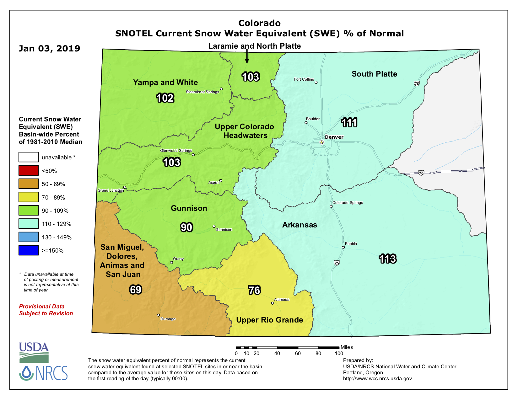
As of Dec. 31, 2018, the Yampa and White River basin had 107 percent of the median snow water equivalent, which is a measurement of how much water is contained within snowpack. At the same time last year, the valley had received 65 percent of the median.
“It’s refreshing to see our snowpack levels kick off at average,” said Kelly Romero-Heaney, water resources manager for the city of Steamboat Springs and a Routt County representative on the Yampa-White-Green River Basin Roundtable…
Steamboat Resort has more snow days than not, with snow falling on 37 of the 63 days the resort has been open. Fifteen of those days were powder days, according to Steamboat Ski and Resort Corp. Senior Communications Manager Loryn Kasten.
In Routt County, the Natural Resource Conservation Service’s snow telemetry sites have received an average of 34 inches of snow. The thickest snowpack is at the Tower site on Buffalo Pass, with 64 inches. The thinnest snowpack is at the Bear River and Lynx Pass sites in South Routt, both with 25 inches.
“Keep doing your snow water equivalency dance,” [Kelly] Romero-Heaney said with a laugh.
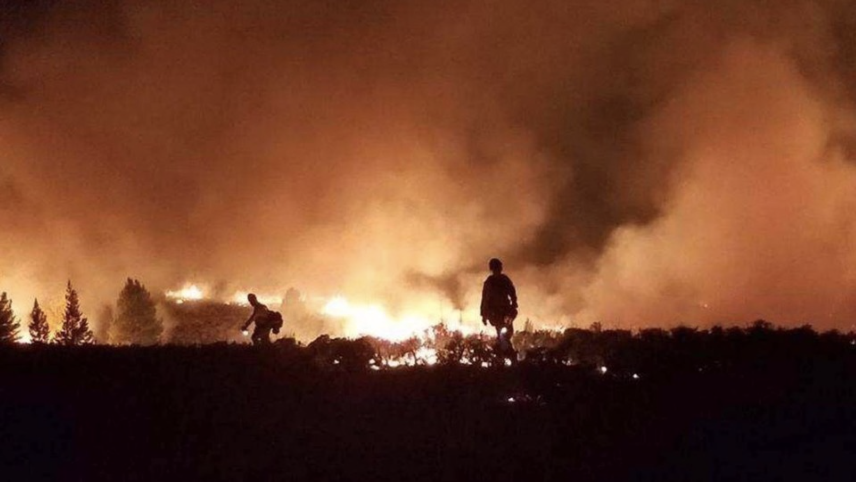
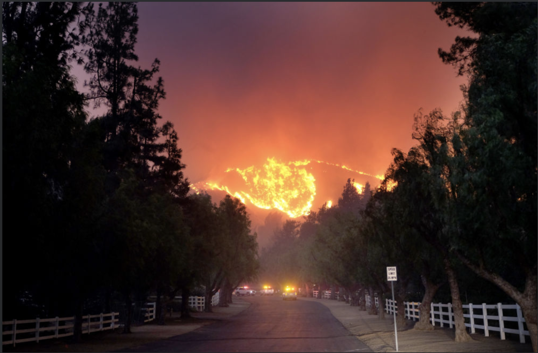
As more people build homes in fire-prone areas, and as climate change and other factors increase the frequency of fires, there is a growing risk to life and property throughout the West — and a lesser known risk to the region’s already endangered water supply. At least 65 percent of the public water supply in the Western U.S. comes from fire-prone areas.
Blazes like the Tubb Fire and 2018’s massive Camp and Carr wildfires can expose the drinking water for millions of people to the risk of contamination by toxic chemicals and parasites. Experts are concerned the new scale of wildfires torching urban areas could cause damage to public water supply that isn’t immediately apparent.
“Lots of structures, vehicles, and man-made materials were involved in the Camp and Carr fires and there isn’t a lot of information on how the environment is affected when these materials burn,” said Clint Snyder, assistant executive officer of California’s Central Valley Water Board.
The concern is prompting more intensive water testing programs following wildfires and spurring utility companies to invest in wildfire mitigation projects across the West.
HOUSES IN THE WOODS
One-third of U.S. homes are now built in what’s called wildland-urban interface (WUI) areas, areas near or on land prone to wildfire. It’s the fastest-growing land use type in the continental U.S.
According to U.S. Forest Service data, in just 20 years, new WUI areas grew by more than 46 million acres, covering an area larger than Washington State.
When these homes become wildfire tinder, insulation, roofing and home furnishings release toxins as they go up in flames, creating new sources of water contamination.
In addition to releasing toxins into the water supply, fires kill healthy tree roots. Without the roots, contaminating sediment and ash are flushed by rain into the reservoirs, rivers and lakes that supply cities with drinkable water.
In 2017 the U.S. Geological Survey published a study that predicted wildfires could double the amount of sediment in a third of the largest western watersheds by 2050. In some areas, sediment could increase 1,000 percent, potentially carrying parasites and harmful metals and chemicals with it.
According to representatives at the California State Water Resources Control Board, bacteria and parasite contamination, rather than chemical contamination, are the main worries in the wake of the Camp Fire, which burned 153,000 acres and 19,000 structures north of Sacramento, killing at least 86 people.
In Paradise, the town most affected by the Camp Fire, 22 out of 24 water systems were tested for contamination and cleared at the time of writing this article, but until the remaining two can be confirmed as uncontaminated, a Boil Water Notice, first released on Nov. 9, will remain in effect.
Solomon’s biggest concern is a parasite called cryptosporidium. When bare soil is exposed because vegetation has burned, the sediment that is flushed into water sources often contains spores of the intestinal infection-causing parasite. While a discomfort to healthy people, cryptosporidium can become life-threatening to people who are undergoing chemotherapy, have AIDS, or are elderly.
“Cryptosporidium form spores and that’s a problem because spores are like armored tanks, encasing the pathogen in a way that allows it to invade even significant amounts of chlorine,” said Solomon.
The increased sediment also creates a costly problem for water treatment plants.
Sediment clogs the microfiltration systems that filter parasites in large water treatment systems, requiring expensive clean-ups.
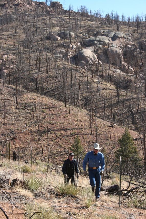
Slopes above Cheesman Reservoir after the Hayman fire photo credit Denver Water.
In 2002, the Hayman Fire cost Colorado utility company Denver Water $27 million, when heavy rains following the fires washed sediment, fallen trees, and man-made debris into the Stronita Springs and Cheeseman Reservoirs. The contaminants had to be filtered out before the water was safe for consumers.
To date, the Tubb Fire is one of California’s starkest examples of post-wildfire water contamination.
Before last year’s larger, deadlier Camp Fire, it was the most destructive California wildfire ever recorded. It burned nearly 37,000 acres, 5,636 homes and businesses, and killed 22 people.
But despite the scope of the blaze, it took a phone call from Gerald Buhrz to alert local authorities to the possibility of water contamination.
“If [he] hadn’t called in to report a chemical smell in the water, we may never have known about it,” said Bennett Horenstein, who was director of Santa Rosa Water during the fire. “It makes me wonder how many times this has happened and gone unreported.”
In total, the City of Santa Rosa had to spend $8 million replacing hydrants, valves, and other water system components in 352 properties, including 1,265 feet of water main.
“What happened in Fountaingrove should be a learning opportunity for water systems nationally,” Horenstein said…
Denver Water, which manages 12 water storage facilities throughout Colorado, announced in January that it’s pledging $16.5 million to the From Forest to Faucets Project, a partnership with the U.S. Forest Service that will protect crucial watersheds from wildfire. Colorado has more than 14 million acres of U.S. National Forest land and almost 90 percent of it is located in watersheds that feed public water supplies.
Officials in Arizona enacted a plan in July that prescribes tree thinning and controlled burns for the three watersheds that feed the C.C. Cragin Reservoir. The project is funded in part by a local utility company called Salt River Project…
“Fire mitigation projects are not just urgent because of the fact that people live near these forests, but the fact that people live downstream from these watersheds,” [Linda Wadleigh] said.