#Drought news: Widespread precipitation is erasing aridity across #Colorado

Click here to go to the US Drought Monitor website. Here’s an excerpt:

Summary

Bitterly cold conditions settled over central portions of the nation, while stormy weather prevailed over parts of the eastern and western U.S. The Southeastern rain afforded localized relief from dryness, while a continuation of the west’s stormy weather pattern brought more drought relief to locales from the Pacific Coast into the Rockies. In contrast, short-term dryness intensified across the southcentral U.S., in particular central Texas…

High Plains

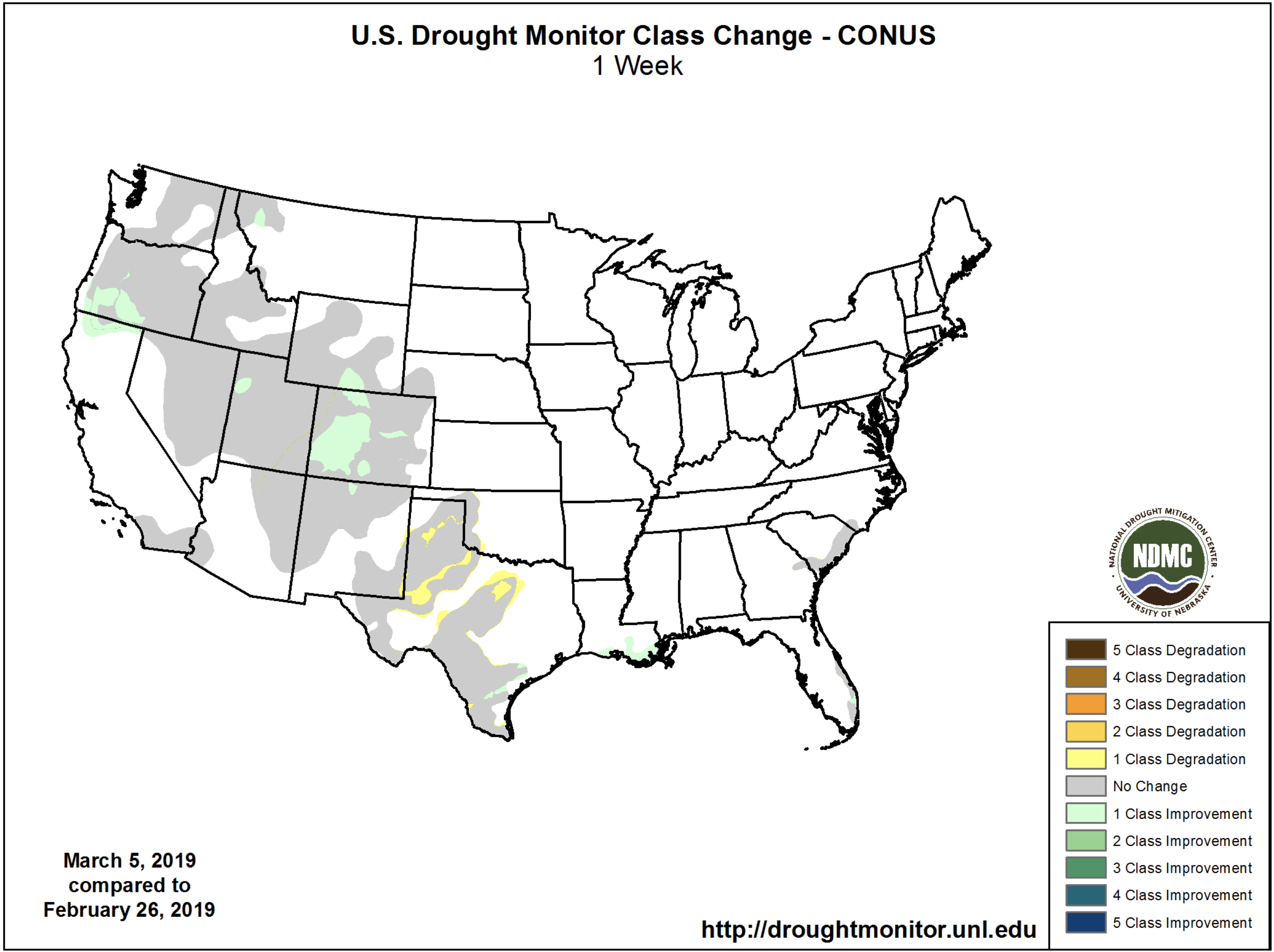
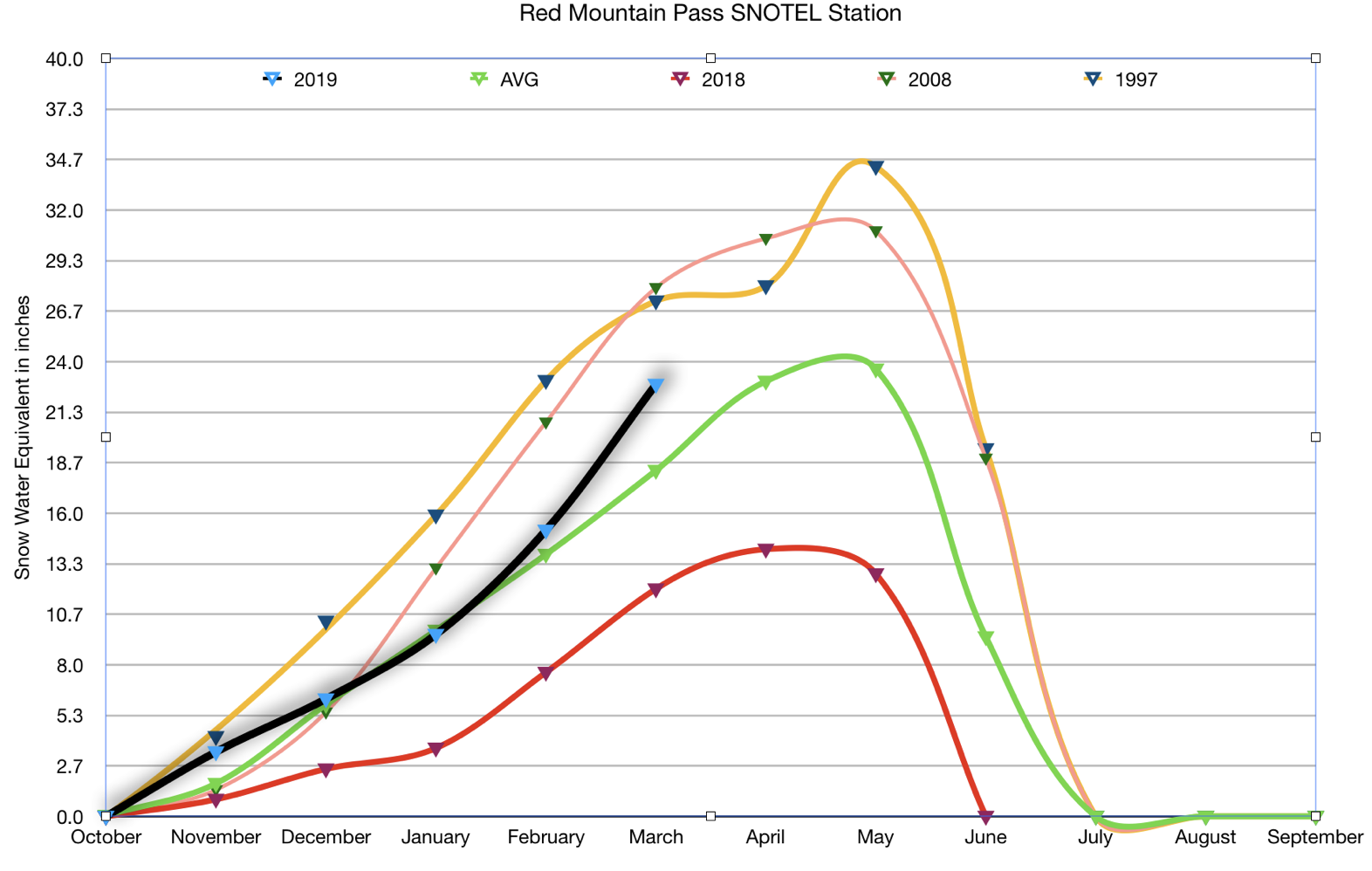
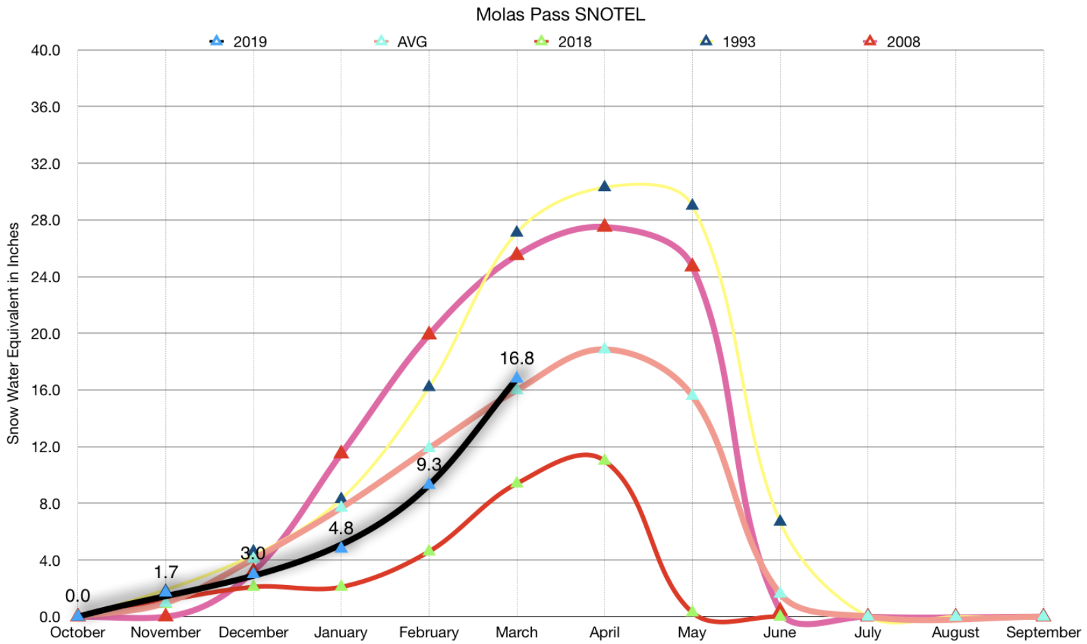
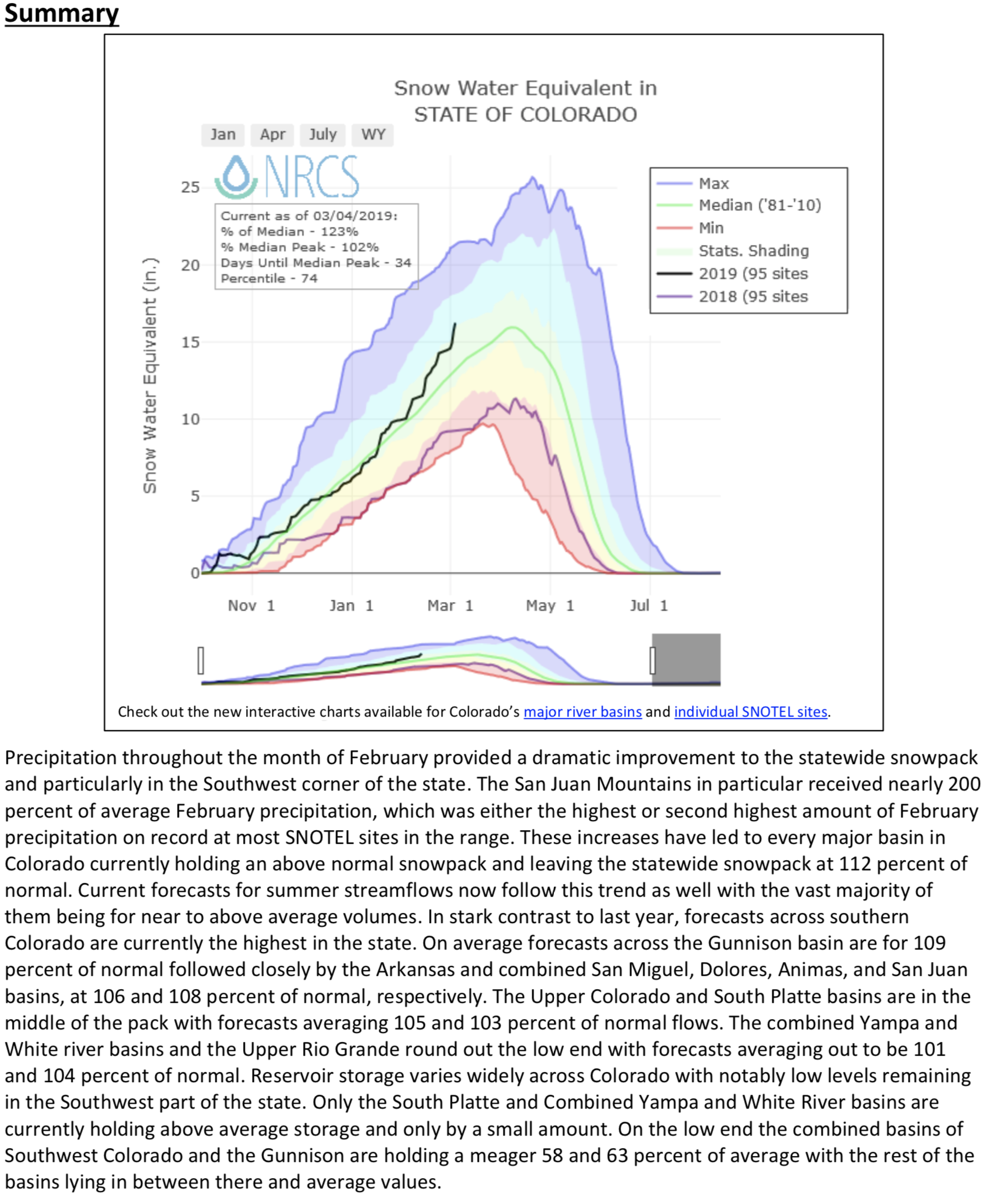
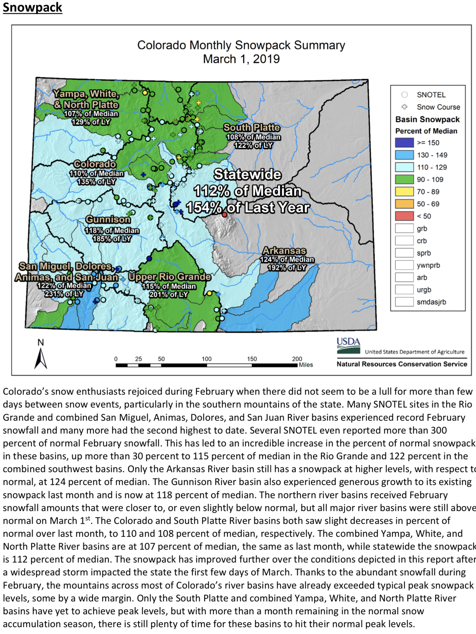
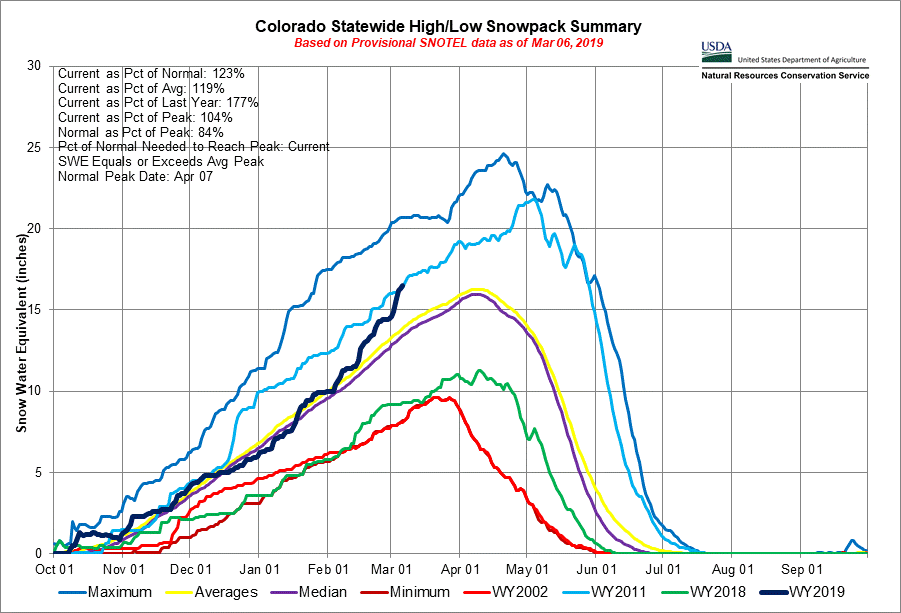
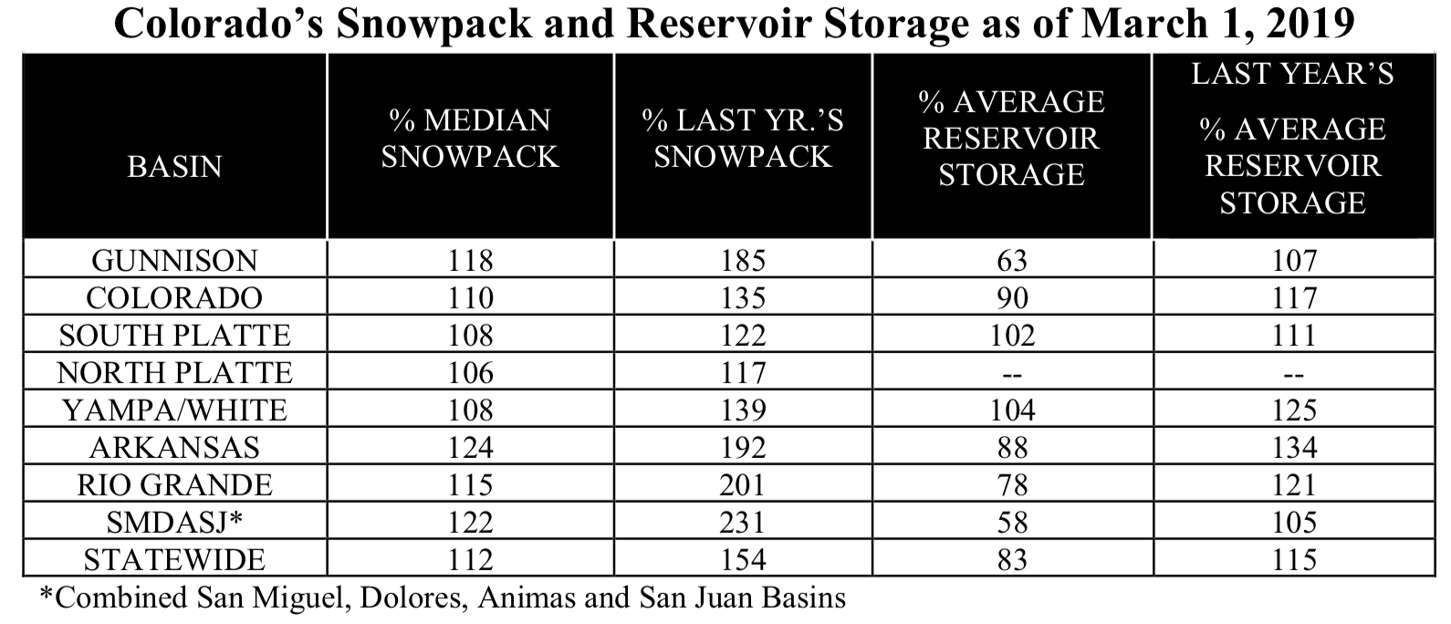
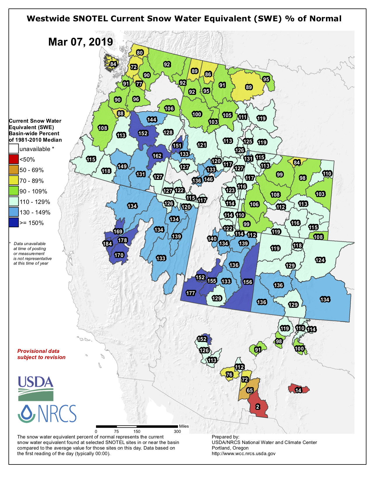
Most of the High Plains remained free of dryness and drought, with a moderate to deep snowpack coincident with temperatures averaging more than 20°F below normal. However, western portions of this region (notably, the mountains) continued to experience significant recovery from long-term Moderate (D1) to Severe (D2) Drought. During the 7-day monitoring period, precipitation totaled 1 to locally more than 3 inches (liquid equivalent) from the Park Range in northern Colorado to the San Juan Mountains in the south. Water-year precipitation has totaled 100 to 150 percent of normal, and mountain snow water equivalents (SWE) are in the 75th to the 100th percentile, indicative of favorable spring runoff prospects. The lingering drought remains most apparent in the longer term, with 24-month precipitation still averaging 50 to 75 percent of normal in the region’s D1 and D2 areas…

West

The ongoing recovery from long-term drought continued over much of the west, though dry conditions lingered over northern- and southern-most portions of the region.

In the Four Corners States, locally heavy precipitation (1-4 inches, locally more) in northern portions of the region afforded relief from Moderate to Extreme Drought (D1-D3) from the central Rockies into northern New Mexico. Water-year precipitation has totaled an impressive 110 to 225 percent of normal over most of the Four Corners, with below-normal precipitation confined to southwestern and northwestern New Mexico. Spring runoff prospects are likewise favorable, with mountain snow water equivalents (SWE) currently at or above the 70th percentile, save for subpar SWE in the Gila Mountains. The Four Corner’s drought is mostly apparent in the longer-term, with 24-month precipitation averaging 55 to 75 percent of normal in the region’s core drought areas.

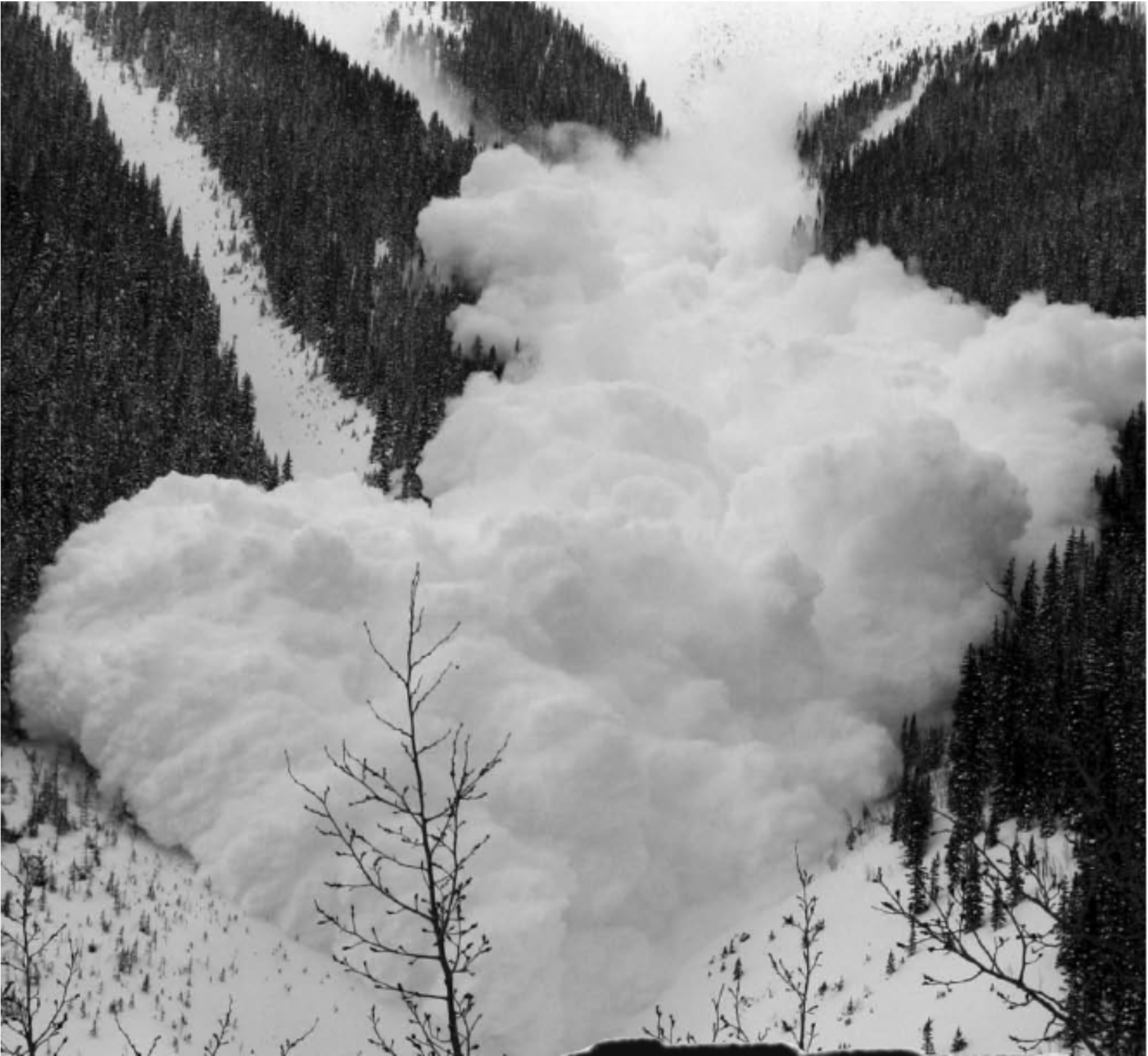
Farther north, heavy rain and mountain snow continued to slam locations from the northern California Coast into the northcentral Rockies. Precipitation over the past 7 days totaled an impressive 2 to 10 inches (locally more) from San Francisco north into the southern Cascades and east to the Sierra Nevada. Outside of a few locales in the southern San Joaquin Valley and in the far north, almost all of California is now reporting precipitation surpluses for the water year. To further illustrate, California’s disappearing Moderate Drought (D1) was limited to small portions in the far north, while Abnormal Dryness (D0) was confined to relatively small sections in northern and southern portions of the state. The wet weather in the north has also afforded additional drought relief in southwestern Oregon, with water-year deficits nearly eradicated from Medford into the southwestern Harney Basin. Despite the overall wet weather pattern, the water year has featured sub-par precipitation (70-80 percent of normal) in the central and northern Cascade Range. Snowpacks are in good to excellent shape in the Sierra Nevada (80th-98th percentile), southern Cascades (60th-92nd percentile), and from the Great Basin into the northcentral Rockies (55th-100th percentile). Conversely, subpar snowpacks remained a concern in the northern Rockies (locally below the 20th percentile) and northern Cascades (10th-30th percentile)…

Looking Ahead

A stormy weather pattern will continue over much of the nation. A series of fast-moving Pacific storms will bring significant precipitation to most of the contiguous U.S., save for parts of the Gulf Coast States, southern California, and from the northern High Plains into the upper Midwest. Fresh snowfall is likely from the Cascades and Sierra Nevada into the Rockies, while another round of moderate to heavy snow may also blanket locales from the central High Plains into the Great Lakes Region. Potentially moderate to heavy rain is also in the offing from the southern Plains into the lower Ohio Valley. The NWS 6- to 10-day outlook for March 12–16 calls for above-normal precipitation across the entire nation, except for drier-than-normal conditions from California into the northern Rockies. Colder-than-normal weather over the western half of the nation will contrast with above-normal temperatures east of the Mississippi.

US Drought Monitor one week change map ending March 5, 2019.

San Juan #Snowpack 2019: Big, but not the biggest (yet) — Jonathan Thompson (@jonnypeace) #ColoradoRiver #COriver #aridification

From RiverOfLostSouls.com (Jonathan Thompson):

Photo credit: http://riveroflostsouls.com

Let there be no doubt: It has been a snowy winter in the San Juan Mountains in southwestern Colorado, along with the rest of the state and much of the nation. Six people have been killed in Colorado avalanches, three of them in the San Juans. The highways leading into Silverton have been closed multiple times this winter due to avalanches, and Red Mountain Pass remains shut and buried with miles of slide debris as I write this early on March 7. Skiing, by all accounts, has been fantastic. If someone were to have gone into hibernation a year ago in the San Juans, and had just woken up today, they’d probably think they had been transported into a completely different world.

A CDOT driver clears debris from the East Riverside slide south of Red Mountain Pass in early March. This slide is the deadliest on Hwy 550 between Durango and Ouray. In the ’60s a reverend and his two daughters were killed here, and plow drivers were killed by the Riverside in ’78 and ’92, not long after the (too-short) snowshed was built. Courtesy Colorado Department of Transportation.

And yet, according to data from a sampling of SNOTEL stations across the San Juans, the March 1 snowpack still did not crack the top three highest levels on record, even though the SNOTEL records only go back less than four decades. Yeah, I know, those of you who have spent much of the winter shoveling out or catching sweet face shots are probably wondering what kind of Bulgarian weed this guy’s smoking. But I’m just the messenger, here, delivering data gathered by remote, automated, and perfectly sober stations, specifically those located near Molas Lake, on Red Mountain Pass, and in Columbus Basin in the La Plata Mountains.

The graphs below show this water year’s snow water equivalent for the first of each month so far, average level for the period of record, 2018 levels, and the two highest snowpacks on March 1 during the period of record.

Red Mountain Pass is so far seeing its 8th heaviest snowpack for 3/1 since 1981.
We’re not sure what’s going on at Molas, where the SNOTEL station showed the March 1 snowpack sitting at average levels. This year is at 14th biggest snows since 1987.
While the snowpack is sitting well above average at Columbus Basin, it remains far below previous years, sitting in sixth place since 1995.

The main takeaways: • The snowpack, i.e. the snow water equivalent, is sitting well above average for the period of record for each station. • The snow water equivalent for each station is currently about two times what it was a year ago. • A lot more snow will have to fall in order to make this the biggest winter on record.

And now for some caveats: • These graphs show snowpack levels at the first of the month, and all three of the sample stations have received two to three more inches of SWE since then in massive early March storms, which could have boosted this year’s ranking a bit. • I chose these three stations because they sit at a high altitude (and had values > 0 last year), and because they are geographically diverse. It’s possible that lower elevation stations have more snow this year than they ever have. I’ll look into that for a future post. • These data are merely for the amount of water in the snow at a specific point of time. They do not necessarily reflect total snow accumulation for the water year. It’s possible that more snow has fallen than in “bigger” years, but that warmer temperatures have melted it. I’ll also look into how this winter’s temperatures compare to previous years in a future post.

February Provides Substantial Increases to Colorado Snowpack — NRCS

Here’s the release from the NRCS (Brian Domonkos):

The month of February brought ample precipitation across the state of Colorado with the South Platte basin being the only in the state that received below average monthly precipitation. The mountains of southwest Colorado fared particularly well. The combined San Miguel, Dolores, Animas, and San Juan basins received 196 percent of average precipitation followed by the Upper Rio Grande and the Gunnison at 175 and 151 percent, respectively. This is great news for those basins after last year’s extremely low streamflows led to depleted reservoir storages going into winter. “Recent storms have led to every major basin in Colorado currently holding above normal snowpack. Additionally, statewide the snowpack has already risen to above the normal peak accumulation which commonly occurs the second week in April. This is good news for the summer water supply situation across Colorado.” notes Karl Wetlaufer, Hydrologist and Assistant Supervisor with the NRCS Colorado Snow Survey.

Statewide Basin High/Low graph March 6, 2019 via the NRCS.

Reservoir storage values remain highly variable across the state and the only basins currently holding above average storage levels are the South Platte and combined Yampa, White, and North Platte which are at 102 and 104 percent of normal, respectively. On the low end the combined San Miguel, Dolores, Animas, and San Juan basins have only 58 percent of average followed closely by the Gunnison at 63 percent. Wetlaufer continued, “Both of these basins are holding some of the lowest reservoir levels seen over the last several decades, so the recent snowfall is welcome news in those areas and will help to begin replenishing reservoir storage after the very low streamflows of 2018.”

Following the trend in snowfall, after this last month all major basins in Colorado now have above average water year-to-date precipitation. As of March 1st, all basins had received a very similar amount of precipitation since the beginning of October, relative to normal, in a range between 108 and 114 percent of average.

Streamflow forecasts in Colorado are currently for near to above average summer streamflow and in many areas the forecasts have notably increased over last month. On the high end the Gunnison basin as a whole is forecast to have 109 percent of average streamflow followed closely by the Arkansas and combined San Miguel, Dolores, Animas, and San Juan basins at 106 and 108 percent, respectively. The average of streamflow forecasts in the Upper Colorado basin is 105 percent of normal and 103 percent in the South Platte. On the low end, but still above normal is the combined Yampa and White River basins which are forecast to have 101 percent of normal flows and 104 in the Upper Rio Grande.

For more detailed information about March 1 mountain snowpack refer to the March 1, 2019 Colorado Water Supply Outlook Report. For the most up to date information about Colorado snowpack and water supply related information, refer to the Colorado Snow Survey website.

#Runoff/#Snowpack news: Huerfano County flood preparedness meeting recap

A firefighting helicopter flies in the foreground while the Spring Creek Fire (August 2018) rages behind it. Photo credit: El Paso County

From KOAA.com (Caiti Blase):

Residents in Huerfano County are preparing for the worst as major flooding could hit the region this year due to the huge burn scar left by the 2018 Spring Creek Fire.

A flood preparedness meeting was held Wednesday night at the Fox Theatre in Walsenburg with dozens of people attending to find out what steps they need to take to get ready for potential flooding.

Officials are warning – whatever you thought you knew about flooding think again.

John Galusha, county administrator for Huerfano County, said, “The burn severity is the highest burn severity recorded in a fire in the United States ever.”

Last summer’s Spring Creek Fire may be over, but the damage it left behind is going to rear its ugly head in the coming months.

Galusha said, “We know that we’re going to have extreme runoff so it’s going to be 7-15 times higher than our average runoff.”

Thousands of homes in Huerfano County could be flooded either by rapid snow melt or monsoon season. The soil in this area was burned so deep during the Spring Fire that it will actually repel water.

From The Farmington Daily Times (Mike Easterling):

The abnormally dry conditions that have prevailed in the Four Corners region for the past year and a half, leaving most of San Juan County in a major drought, have shown signs of dissipating this winter.

But even with the snowpack in the southwest Colorado high country at an encouragingly high level, an official at the National Weather Service in Albuquerque is offering a mixed perspective on the region’s long-term moisture situation.

“That’s the big question,” Royce Fontenot, the senior service hydrologist for the NWS office in Albuquerque, said today. “Do we balance the stronger short-term upswing (in moisture) versus the longer-term deficit?”

Fontenot said the NWS is nowhere near ready to declare an end to the drought.

“We’re cautiously optimistic we’re going to continue to see improvement, but we’re still looking at the long-term drought and the damage it has done to the system.”

Dry conditions settled in over San Juan County in early October 2017, Fontenot said, resulting in a devastatingly dry winter of 2017-2018 and a poor monsoon season last summer. Over the past 17 months, the county has received only 55 percent of its normal moisture, and that has left most of the county locked in varying stages of drought, according to the U.S. Drought Monitor.

The far west edge of the county is in a severe drought, the third-worst classification. Most of the rest of the county is in extreme drought, the second-worst classification. And an oval-shaped patch extending east from Farmington to the Rio Arriba County line is in an exceptional drought, the worst stage. That classification is typified by exceptional and widespread crop/pasture loss and shortages of water creating water emergencies.

But Fontenot said conditions have improved over the last 90 days. Over that period, the normal amount of precipitation the Farmington area would have expected to see was 1.65 inches. Instead, he said, it has gotten. 2.97 inches — 180 percent of normal…

Even more moisture has fallen in the mountains of southwest Colorado, the watershed that feeds San Juan County’s rivers. According to the U.S. Department of Agriculture’s Colorado SNOTEL website, the snowpack in the San Miguel, Dolores, Animas and San Juan rivers watershed was 131 percent of median today, the wettest region in all of Colorado…

Windy conditions can disperse much of that snow, and it can simply evaporate, Fontenot said. And if it turns warm too quickly this spring, the snowpack can all melt at once, sending much of that moisture downstream before it can be used.

Another factor working against the region, he said, is the soil moisture content. The period from October 2017 to December 2018 was so dry, he said, that much of the snow that has fallen from the sky won’t wind up in a river as it normally would.

From The Associated Press (John Antczak):

California is drenched and its mountains are piled high with snow amid a still-unfolding winter of storms that was unimaginable just a few months ago.

Drought conditions have almost been eliminated, hills blackened by huge wildfires are sporting lush coats of green, and snow has fallen in the usually temperate suburbs of Southern California, where chilly conditions have made jackets and scarves the rule…

Blizzards have pounded the Sierra Nevada, burying the towering mountain range in massive amounts of snow. On the eastern side of the range, for example, the Mammoth Mountain resort reported nearly 47.8 feet (14.5 meters) of snow at the summit so far this season.

While frequently disrupting travel, the storms stoked a big part of the state’s water supply — the Sierra snowpack that melts and runs off into reservoirs during spring and summer.

The California Department of Water Resources reported Thursday that the Sierra snowpack is now 153 percent of average to date.

A manual measurement at Phillips Station off U.S. 50 near Sierra-at-Tahoe found a snow depth of 113 inches (287 centimeters) and a snow water equivalent of 43.5 inches (110.5 centimeters), more than double what was recorded there in January.

Phillips Station is where then-Gov. Jerry Brown attended a snowpack survey in April 2015 that found a field barren of any measureable snow. Brown later ordered Californians to use less water. On Thursday, the department was unable to livestream the measurement because stormy weather cut the cell connection…

Where it hasn’t snowed, there has been rain, and a lot of it.

Nearly 21 inches (53.3 centimeters) of rain fell in 48 hours this week near the Northern California wine country city of Guerneville, where the Russian River was slowly receding Thursday after extensive flooding…

The U.S. Drought Monitor reported Thursday that more than 87 percent of California was now free of any level of drought or unusual dryness. Just 2.3 percent — along the Oregon border — was in moderate drought, and the remainder was in a condition called abnormally dry.

Three months ago, nearly 84 percent of the state was in moderate, severe or extreme drought, and the rest was abnormally dry.

Westwide SNOTEL basin-filled map March 7, 2019 via the NRCS.

2019 #COleg: SB19-184 (Authority Colorado Water Institute Study Blockchain Technology) would authorize research of block chain applicability to markets, water banking, water rights, and administration

A headgate on an irrigation ditch on Maroon Creek, a tributary of the Roaring Fork River. Photo credit: Aspen Journalism/Brent Gardner-Smith

From CoinDesk.com (Yogita Khatri):

Lawmakers in Colorado want the U.S. state to study the potential of blockchain technology in water rights management.

Republican senator Jack Tate, along with representatives Jeni James Arndt (Democratic) and Marc Catlin (Republican), filed [SB19-184 (Authority Colorado Water Institute Study Blockchain Technology)] on Tuesday, proposing that the Colorado Water Institute should be granted authority to study how blockchain technology can help improve its operations.

The institute, an affiliate of Colorado State University, should study various use cases of blockchain tech, including water rights database management, the establishment of water “banks” or markets, and general administration, according to the bill.

The study would be carried out only after the institute has received enough money, and would be allowed to solicit and accept donations from private or public institutions for the purpose. The findings should later be reported to the general assembly, the lawmakers said.

The Colorado Water Institute has the mission to “connect all of Colorado’s higher education expertise to the research and education needs of Colorado water managers and users.”