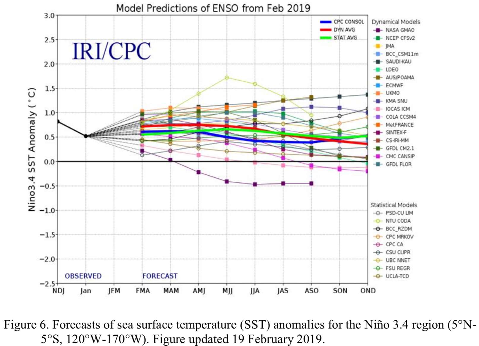
Synopsis: Weak El Niño conditions are likely to continue through the Northern Hemisphere spring 2019 (~80% chance) and summer (~60% chance).
El Niño conditions strengthened during February 2019, as above-average sea surface temperatures (SSTs) increased across the equatorial Pacific Ocean and the associated atmospheric anomalies became increasingly well-defined. The SST index values in the Niño3, Niño3.4 and Niño4 regions all increased during February, with the latest weekly values near +1C in each region. The anomalous upper-ocean heat content (averaged across 180°-100°W) increased appreciably during February, due to an increase in above-average temperatures at depth in association with a downwelling equatorial oceanic Kelvin wave. Enhanced equatorial convection prevailed near the Date Line, while suppressed convection was observed over Indonesia. Low-level wind anomalies were westerly in the central Pacific Ocean, while upper-level wind anomalies were mostly westerly over the far western and far eastern Pacific. The equatorial and traditional Southern Oscillation Index values were both negative (-1.4 standard deviations). Overall, these features are consistent with weak El Niño conditions.
The majority of models in the IRI/CPC plume predict a Niño 3.4 index of +0.5C or greater through the Northern Hemisphere early autumn 2019. Given the recent downwelling Kelvin wave, and the increase in both the SSTs and subsurface ocean temperatures, most forecasters expect positive SST anomalies to persist across the central and eastern Pacific for at least the next several months. During that time, forecasters predict the SST anomalies in the Niño 3.4 region to remain between +0.5C and +1.0C, indicating weak El Niño conditions. However, because forecasts made during spring tend to be less accurate, the predicted chance that El Niño will persist beyond summer is currently about 50%. In summary, weak El Niño conditions are likely to continue through the Northern Hemisphere spring 2019 (~80% chance) and summer (~60% chance); click CPC/IRI consensus forecast for the chance of each outcome for each 3-month period.
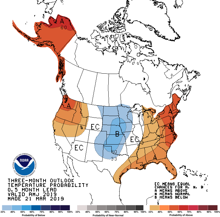
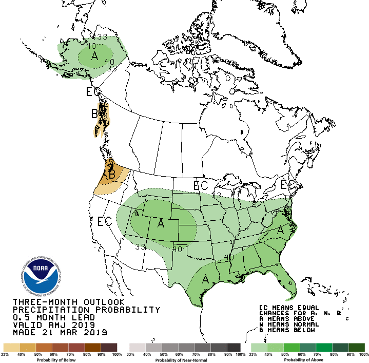
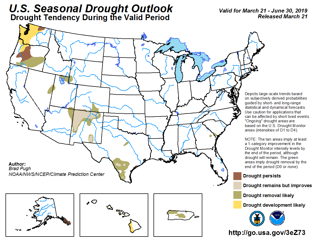
Seasonal temperature outlook through June 30.2019 via the Climate Predication Center.Seasonal precipitation outlook through June 30.2019 via the Climate Predication Center.Seasonal drought outlook through June 30.2019 via the Climate Predication Center.
Click on a thumbnail graphic to view a gallery of drought data from the US Drought Monitor.
US Drought Monitor March 19, 2019.
West Drought Monitor March 19, 2019.
Colorado Drought Monitor March 19, 2019.
Click here to go to the US Drought Monitor website. Here’s an excerpt:
Summary
A historic major winter storm impacted much of the country this past week with blizzard conditions, category-2 hurricane-force winds, heavy rain, thunderstorms, tornadoes, and flooding. Funnel clouds and tornadoes were seen in south central Arizona and southeastern New Mexico. Up to a foot of snow fell across the Denver, Colorado, area, while up to two feet fell over southeastern Wyoming, western Nebraska, and into southwestern and central South Dakota. To the south, thunderstorms rolled across Texas and parts of the lower Mississippi River Valley into the Tennessee and Ohio Valleys, including eastern Arkansas, southwestern Tennessee, and northwestern Mississippi. Heavy rainfall melted snow and led to flooding from Kansas, Nebraska, and South Dakota to the western Great Lakes. Much of the South, however, from southern Texas eastward, missed out on most of the precipitation and conditions continue to dry…
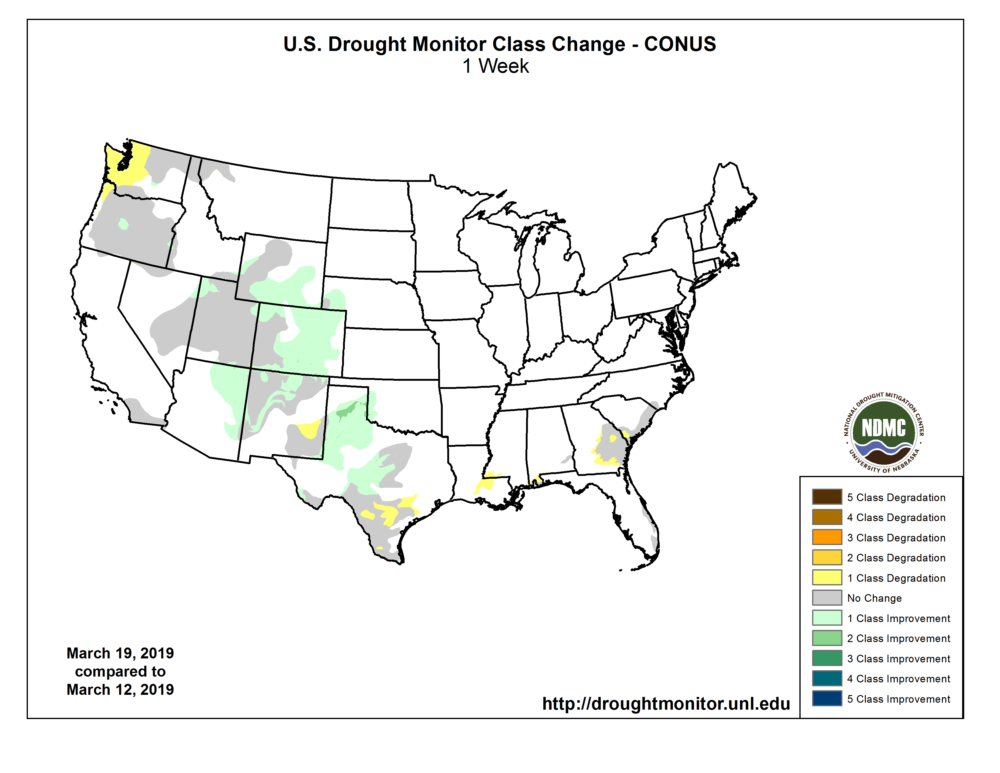
Most of the High Plains were impacted by a major winter storm early in the drought week that brought blizzard conditions, heavy rain, and dangerous flooding. Except for the western region where abnormally dry conditions (D0) are present, the remainder of Colorado saw widespread improvement, due to the recent storm and a generally very active weather pattern since February that has left excellent snowpack, with much of the north half and east returning to normal conditions. Severe drought (D2) shrank significantly in the southern part of the state. With heavy snow–one to two feet in areas–abnormally dry conditions were alleviated across most of the western Nebraska panhandle and in eastern and southern Wyoming…
Last week, California emerged from drought conditions for the first week since December 11, 2011, breaking its 376-week streak. Reservoirs continue to slowly replenish in areas of the state still experiencing abnormal dryness (D0) and no further changes were made here. However, areas of abnormal dryness and drought continued to decline in other western states this week, due to recent above-average precipitation and excellent snowpack conditions at higher elevations. Arizona and New Mexico in particular saw widespread 1-category improvements. Notably, exceptional drought (D4, the worst category depicted on the drought map) was eliminated and extreme drought (D3) broadly contracted in northern New Mexico. In Oregon, the small area of severe drought (D2) in Deschutes County was eliminated. Moderate drought in the rest of the state remains unchanged as temperatures begin to warm and soil moisture is still dry when considering conditions over the past year or so. In contrast to other parts of the West, western Washington and along the northern coast of Oregon have seen below-normal precipitation over the past few months on average and stream flows are quite low here, even record low in some places. Abnormally dry conditions were expanded across this area. Reports indicate that the dry weather has caused an increase in brush fires in Whatcom, Mason, Grays Harbor, Cowlitz, and Clark Counties in Washington…
Heavy precipitation from a major storm system on the 13th fell over abnormally dry (D0) and drought areas in western Oklahoma and northern and central Texas, where conditions widely improved by 1 category, and even 2 categories from western Swisher County northeastward to western Gray County. Those areas received enough rainfall to alleviate deficits at both long- and short-term time scales. The precipitation largely missed southern parts of Texas, Louisiana, and Mississippi. Abnormally dry conditions spread from southern Alabama into the southeastern corner of Mississippi and an area was introduced from the southwest corner of the state southwestward through Lafayette Parish to the northern tip of Vermillion Parish near the Gulf of Mexico. Dryness and drought expanded eastward in southern Texas, and three pockets of severe drought (D2) were introduced: two center on Zavala and Atascosa Counties and one area sits on the border of Jim Hogg and Starr Counties in the far south…
Looking Ahead
Over the week beginning Tuesday, March 19, according to NOAA’s Climate Prediction Center, light rain is generally expected over much of the contiguous United States, with regional and localized amounts of around an inch or so anticipated across several states, from California to Arkansas, along with most of the eastern seaboard from North Carolina to Maine. Already dry areas in the Southeast are expected to continue to dry. Looking further ahead to March 25-29, there is a high probability Alaska will see above-average temperatures and precipitation. The central contiguous U.S. and Pacific Northwest may also see above-average temperatures, while most of California, eastern Nevada, and the Northeast may have below-average temperatures. This timeframe may also be wetter than average across most of the region, with the exception of the upper Northeast and northern Michigan. Please note the forecast confidence for this period is below average.
US Drought Monitor one week change map through March 19, 2019.
Water leaders from the seven states that make up the Colorado River basin are one step closer to finalizing a drought contingency plan. Representatives from Colorado, Wyoming, Utah, New Mexico, Nevada, California and Arizona met in Phoenix Tuesday to sign a letter to Congress asking for federal approval of the plan.
Recent heavy snows in the southern Rockies have relieved some short-term pressure on the region’s water supplies. If dry conditions in the southwest return in the next six years, the plan would force Arizona, Nevada, California and Mexico to cut back the amount each takes from the overallocated river system.
If snowpack remains high the next few years the plans might never be used.
“Today is a very important day in the history of the Colorado River,” said U.S. Bureau of Reclamation commissioner Brenda Burman, who for more than a year has pressured state water managers to agree on voluntary cutbacks. “Today the seven basin states have come to an agreement and signed together a letter to Congress memorializing that agreement. The intrastate drought contingency plans are done. They are complete.”
In the letter, water leaders from throughout the basin say they want to execute the drought contingency plan no later than April 22, 2019.
In declaring the plans done, Burman also decided to rescind her call to Colorado River basin state governors for input to craft a federal plan should the states fail to coalesce.
The plan has been cobbled together through a series of agreements over the last five months among the states that make up the Colorado River watershed. Nevada first approved its portion of the plan in November 2018. Colorado, Wyoming, Utah and New Mexico followed suit in December. Starting Jan. 31, 2019 California and Arizona failed to meet a series of federal deadlines while the two states attempted to calm warring intrastate factions.
In Phoenix, water officials attempted to provide closure to the drought contingency plan process, while acknowledging big hurdles remain, including projected climate impacts to snowpack and the river’s structural deficit where more water exists on paper in the form of water rights than in the system itself…
“This is definitely a euphoric high point that we’re in right now, but there are miles and miles to go before we sleep,” said Upper Colorado River Commission member James Eklund. He signed the letter on behalf of the state of Colorado.
The euphoria isn’t shared by all users in the southwestern watershed. The plan now moves forward without the support of the single largest user of the river’s water. The Imperial Irrigation District (IID) in southern California said it would only sign on to the drought plan when it received $200 million in federal funds to mitigate public health and environmental problems brought on by the shrinking Salton Sea.
“By forging ahead, what they are saying is that the only acceptable way to check the boxes marked ‘IID’ and ‘Salton Sea’ is to erase them,” said IID board president Erik Ortega in a written statement. “What they’re also saying is that getting the [drought contingency plan] done is more important than getting it right.”
[…]
The drought contingency plan overlays onto a set of 2007 guidelines that govern how the river’s reservoirs are managed. Those guidelines weren’t able to keep up as dry conditions and chronic overuse in the basin caused reservoirs to drop to critical levels. The plan is meant to provide temporary stability while water managers negotiate a new set of operating guidelines which go into effect in 2026…
“If we were aliens visiting Earth from another system years from now would we run it this way? Probably not,” said Eklund, of the Upper Colorado River Commission. “But there are history and legacy, pieces of law and policy, politics in this basin that have guided us to where we are and what we have to do. And I think given the hand we’ve been dealt this is a pretty outstanding moment.”
FromThe Denver Post (Bruce Finley) via The Fort Morgan Times:
This “drought contingency” plan completed by the seven Western states to meet an extended federal deadline is “meant to avoid a crisis on the river,” said U.S. Bureau of Reclamation Commissioner Brenda Burman.
After 2026, the feds will look at flows in what scientists project will be a more diminished Colorado River and, working with states, “we will negotiate our next step,” Burman said.
This complex water plan hashed out since 2017 depends on all residents of the West using less water to deal with a 19-year shift toward aridity. Negotiators tinkered with fundamentals of the 1922 law that divvies up shares of Colorado River water for each state — an improvisation to try to address one of the planet’s toughest water problems caused by chronic overuse and climate change.
For two years, federal water authorities at the brink of declaring a shortage — which would trigger a federal takeover of managing deliveries from the Colorado River — have been pushing states to hash out drought plans as a temporary bridge toward sustainable use of the river. Congressional officials have scheduled hearings next week aimed at implementing the plan…
Federal scientists have projected that, if dry times continue, reservoir operators within five years will not be able to deliver water as usual to downriver cities including Phoenix, Los Angeles, Tucson and San Diego. The other main reservoir on the Colorado River, Lake Mead, remained only 41 percent full, with feds projecting that by the end of 2019, the water level will barely exceed (by about 6 feet) the threshold for federal declaration of that official shortage.
“This plan means we have seven states concerned about how to move forward and, instead of balkanizing the basin into fractured state interest groups, we’re all working together to control our own destiny,” said James Eklund, the Denver-based attorney who represented Colorado through extended multistate negotiations.
The outlook for the Colorado River “has not been rosy for the last 20 years. This snowpack does look decent. It may be an outlier. We have got to plan for the worst and hope for the best,” Eklund said in an interview with The Denver Post on Tuesday.
For Colorado, the plan “does not obligate us to use less water,” Eklund said, but instead creates incentives for conservation. It allows Colorado and other upper basin states (Wyoming, Utah, New Mexico) to use Lake Powell as a bank account for extra water. Under river drought protocols negotiated in 2007, extra water in Powell above the amount those states are required to deliver to the lower basin states (Arizona, Nevada, California) could be moved out toward Lake Mead to help address the chronic depletion there.
That now has changed so that ranchers, growers, cities and industries that use less water can store it in Lake Powell. Federal officials said they hope this plan, once Congress directs implementation, will immediately create incentives for using less water.
“If the Colorado River reservoirs keep going down and down and down, then two sectors will feel the brunt of the pain: the environment and people in poverty. Those are the two that always, globally, when there is water stress, feel the pain disproportionately,” Eklund said. “We’re trying, with this contingency plan, to go a different route that allows us to manage our water and the river system so that it stays healthy longer. It allows us to keep away from that acute crisis that, if history is any guide, would hit hardest on the environment and people in poverty.”
A key concern for upper basin states has been the electricity generated at the federally run dam atop the Grand Canyon. If Lake Powell water, formed by that dam, drops 81 feet lower than it was this week, cities including Denver, Pueblo, Colorado Springs and scores of rural electrification districts that rely on distribution of electricity by the Western Area Power Administration could see sharp increases in their power bills…
Beyond the West’s booming cities, expanding fossil fuels and other industries, and agricultural operations, semi-arid landscapes and wildlife, including endangered fish and bird species, depend on healthier ecosystems along the Colorado River…
“If we don’t do something to address the drought situation for agriculture, cities and industry, and stabilize the river system, then the environment is going to suffer. This is a critically important step,” said Matt Rice, Colorado River Basin program director for the advocacy group American Rivers.
“Realistically we have to understand that with the huge economy driven by this river, we have to figure out ways to stabilize it,” Rice said, “or else rivers, the natural environment and recreation are going to suffer most.”
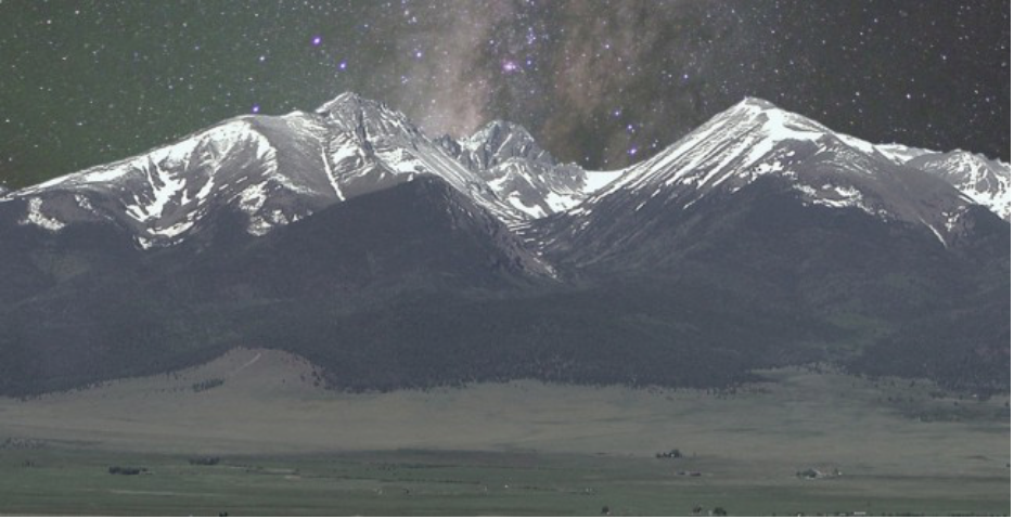
Headwaters of the Arkansas River basin. Photo: Brent Gardner-Smith/Aspen Journlaism
From the Upper Arkansas Water Conservancy District (Terry Scanga) via The Ark Valley Voice:
Most discussions involving water supply or quality require a good examination of historical perspective of water development. For this reason, understanding the system by which water is and has been allocated in Colorado since statehood, is a good starting point.
Water in Colorado is allocated as a private property right through a system referred to as the Appropriation Doctrine. It is the only arid Western state that utilizes a pure form of this doctrine called the “Colorado Doctrine”. This doctrine is enshrined in the state’s constitution. It is a constitutional right for the citizens of Colorado to an appropriation of water based on its beneficial use. Although many legislative statutes deal with water appropriation and use, these all rely upon, and must comport, with the basic constitutional right granted the citizens of the state.
This article is not intended to delve into the Appropriation Doctrine, except to point out that water rights and decrees are granted as a private property right. In fact, this system is automatically designed to apportion available water supply without undue interference from government, except for the administration of the existing water decrees or through the water court.
In 2005 legislation was passed creating the inter-basin compact committee and the nine basin roundtables. The basins utilized the Statewide Water Supply Initiative (a project to calculate the available water supply compared to demand –a needs assessment) to identify the projects and processes needed to address any water supply gap out to the year 2050; for all uses– municipal, industrial, irrigation (agricultural), environmental and recreational. Water entities and individuals were involved in each basin throughout the state to develop these plans.
Projects were identified and some were funded in part with grants from the state’s Colorado Water Conservation Board. The Colorado Water Plan was developed from these plans and processes. These projects have gone a long way to make available the necessary water supplies for the future. Many of the projects are ongoing and more will be needed to meet future needs.
Colorado is an arid state with future shortages forecast in the higher growth regions. In the Arkansas Basin, many junior water rights were established during high precipitation periods. Due to this, the Arkansas Basin today is considered an over-appropriated basin meaning that on average there are more decreed water rights than water available. Most of these junior water rights are decreed for irrigation use in agriculture. In the Arkansas Basin shortages are forecast for all water uses.
The Colorado Water Plan is a collection of the ideas and projects on how we can meet future water demands. Meeting the future need revolves around developing new Colorado River Supplies and Alternative Agricultural Transfers coupled with storage. The Colorado River normally has water that is unused and could be utilized to fill the gaps in the higher growth regions. Presently Colorado is well ahead in meeting its Compact obligations on the Colorado River, despite unsubstantiated claims from some state politicians and the administration that Colorado may be unable to meet its obligations.
Agricultural irrigation uses 80 percent or more of the available supply statewide. Some of these uses could be temporarily interrupted through court approved Lease-Fallowing agreements, and the water owner compensated, to meet shortages in drier years. In wet years existing storage and new storage could be utilized to save the excess for drier times. Storage projects, including alluvial storage, need to be built to meet the future needs. Water storage operations could be adapted to meet multiple uses for stream management, to meet increased demands for the environment and recreation.
Through the existing Appropriation System, the above plans and others are underway to meet this future need. All this can, and should, be completed through the Colorado Doctrine of Appropriation, a strong legal framework to guarantee the security, reliability and flexibility in the development and protection of water resources.
In terms of water supply, the greatest threat for the future would be a loss or erosion, through legislative or administrative action, of the time-tested Colorado Doctrine of prior appropriation. Actions are underway to use the water plan as a framework to advocate for the use of policy to appropriate water. Using policy for water appropriation would give the administration and legislature a pathway or initiative to utilize legislation, in lieu of the more deliberate Appropriation system that is designed to protect existing water rights from injury. This strongly suggests that the legislature and administration may attempt to act upon perceived crises to garner support to move future appropriations or changes of current water use through legislation instead of the water court system.
Already underway is a Demand Management Plan that will allow administrative policies to transfer water rights from agriculture through Deficit Irrigation, or by utilizing an undefined process termed “Conserved Consumptive Use”, to Lake Powell, or to municipal use. In the Arkansas Basin most irrigation is already in a deficit so there is no water to be saved. Under Colorado’s pure form of prior appropriation, in low flow periods, water rights are curtailed automatically to force reductions in use. There is no need to use state policy to create conservation.
The frightening part of these actions is that, if successful, the only way for water right owners to protect themselves from injury will be expensive court action. If legislation is successful in adopting the concept of “Conserved Consumptive Use” it is possible we will see lower flows in the Arkansas River due to a reduction in trans-mountain diversions. These diversions support all uses in the river, such as the voluntary flow management program. Instead of water flowing to the Arkansas River, some may flow down the Colorado River to Lake Powell for storage and eventual evaporation there, under a plan called Demand Management.
In the Upper Arkansas Basin water quality has been addressed is various ways. The Arkansas River was polluted by mining runoff and is normally affected by natural geologic formations. Most of this pollution has been cleaned-up, and today there are large sections of gold medal fishing. Studies conducted by the US Geologic Survey have concluded that most of our ground water is of good quality. These are good things.
But the threat to water quality from sediment runoff from burn areas in our forests are real. Due to the beetle infestations and decimation of the forest stands in the US Forest lands, fire is more likely and has occurred.
The after effects of fire is larger than normal storm runoff. This will, and has already caused, heavy sediment loading on our streams and the Arkansas River. The Upper Arkansas Water Conservancy District (UAWCD) and the Arkansas Basin Roundtable is working with the US Forest Service and local entities to address some of these areas. Locally, the UAWCD is working with the Forest Service on a pilot project to remove beetle killed forest stands and make it a commercially viable resource. If successful, this may be part of the solution.
In the lower part of the Upper Arkansas River Basin, in Eastern Fremont County, there is a geologic formation that contains selenium that contributes to contamination in this part of the Arkansas River. At this time simply identifying these areas is a challenge, but it is being worked on by the US Geologic Survey. Most of this type of contamination primarily affects the Lower Arkansas Basin. Delivery of good municipal drinking water supplies is being undertaken by the South Eastern Colorado Water Conservancy District, with the construction of a pipeline from Pueblo Reservoir to the Lower Basin communities.
Colorado’s U.S. senators said this week they will both fight hard for full funding of the Land and Water Conservation Fund despite the Trump administration’s plans to gut the program that’s pumped more than $268 million into the state for parks, ball fields, trails and open space.
“Congress finally secures LWCF for future generations, and the administration turns around and tries to cut its funding. This is exactly why Coloradans are so frustrated with Washington,” Democratic Sen. Michael Bennet told the Vail Daily on Tuesday via a spokeswoman.
Bennet was referring to the signing last week of the John D. Dingell Jr. Conservation, Management and Recreation Act (formerly the Natural Resources Management Act) by President Donald Trump — the day after the White House released a proposed 2020 budget with deep cuts to the LWCF and other public lands programs…
Established by Congress in 1965, the LWCF uses offshore drilling lease fees to develop parks, wildlife refuges and recreational facilities on federal, state and local lands. It also funds additions and upgrades to national parks, forests and other public lands, including projects in western Colorado. Trump’s budget would reportedly slash LWCF funding by 95 percent…
State groups dependent on the funding would love to see an end to the annual budget battle for the program, which is now permanently reauthorized and collecting money from drilling operations.
“I struggle with that; I struggle with the whole (funding) concept, not just LWCF but the Forest Service and BLM budgets as a whole,” said Scott Jones, chairman of Colorado Parks and Wildlife’s State Recreational Trails Committee. “When Land and Water Conservation Fund money went away, the non-motorized side of the state trails program almost disappeared. It would have been less than a million bucks a year, and that was going to be a big problem.”
[…]
The ongoing construction of the Continental Divide Trail depends on LWCF money, particularly in areas where there’s no nearby federally owned public land. In those cases, proponents of the trail use LWCF funds to acquire private land for the trail.
In a statement, the Continental Divide Trail Coalition blasted the president’s “drastic cuts to LWCF,” which the coalition argued “undermined White House claims of support for the program.”
Teresa Martinez, executive director of the Golden-based CDTC, celebrated the renewal of the program but said it’s time to “get back to work to fight to ensure strong funding for LWCF.”