December 20, 2025
The past several weeks have felt more like an extension of fall rather than the beginning of winter in Colorado. While the warmth has been a welcome reprieve to the winter-loathers, it has been accompanied by dry conditions that have brought worsening drought, poor snowpack, and fire danger. In this post, we’ll look back at some recent trends we’ve been watching and provide a look forward at what we might expect as we head into the start of 2026.
Snowpack and snowfall
We’ll kick off the post with a late December snowpack check-in. Unfortunately for CO (and the West more broadly), there is little good news to report. Looking at percent of 30-year average (1991-2020) snow water equivalent (SWE), a fundamental snowpack metric, shows all of Colorado’s river basins running much below average as of December 18. Conditions are similarly poor throughout the state, with all major river basins sitting between 54% to 63% of their normal snowpack.
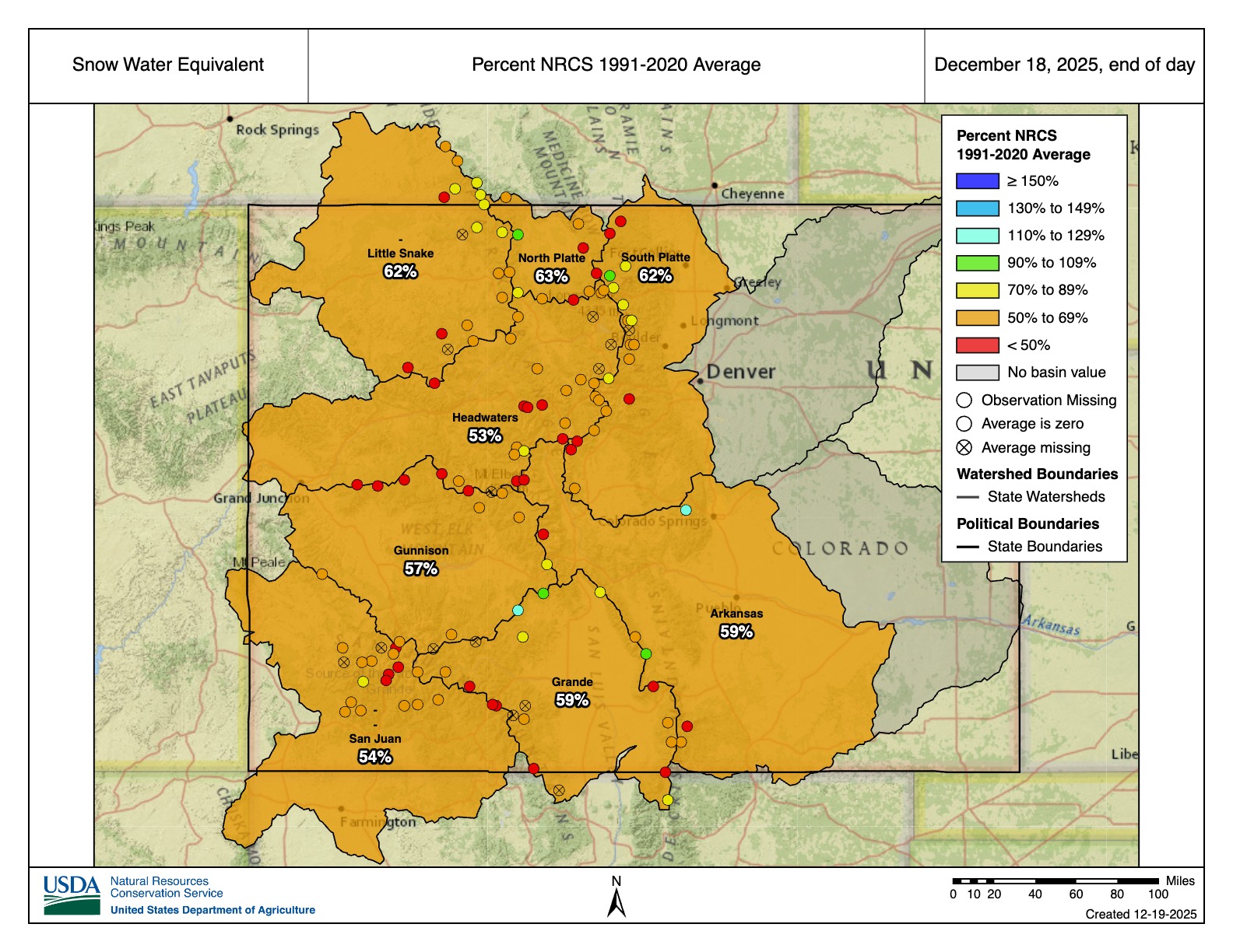
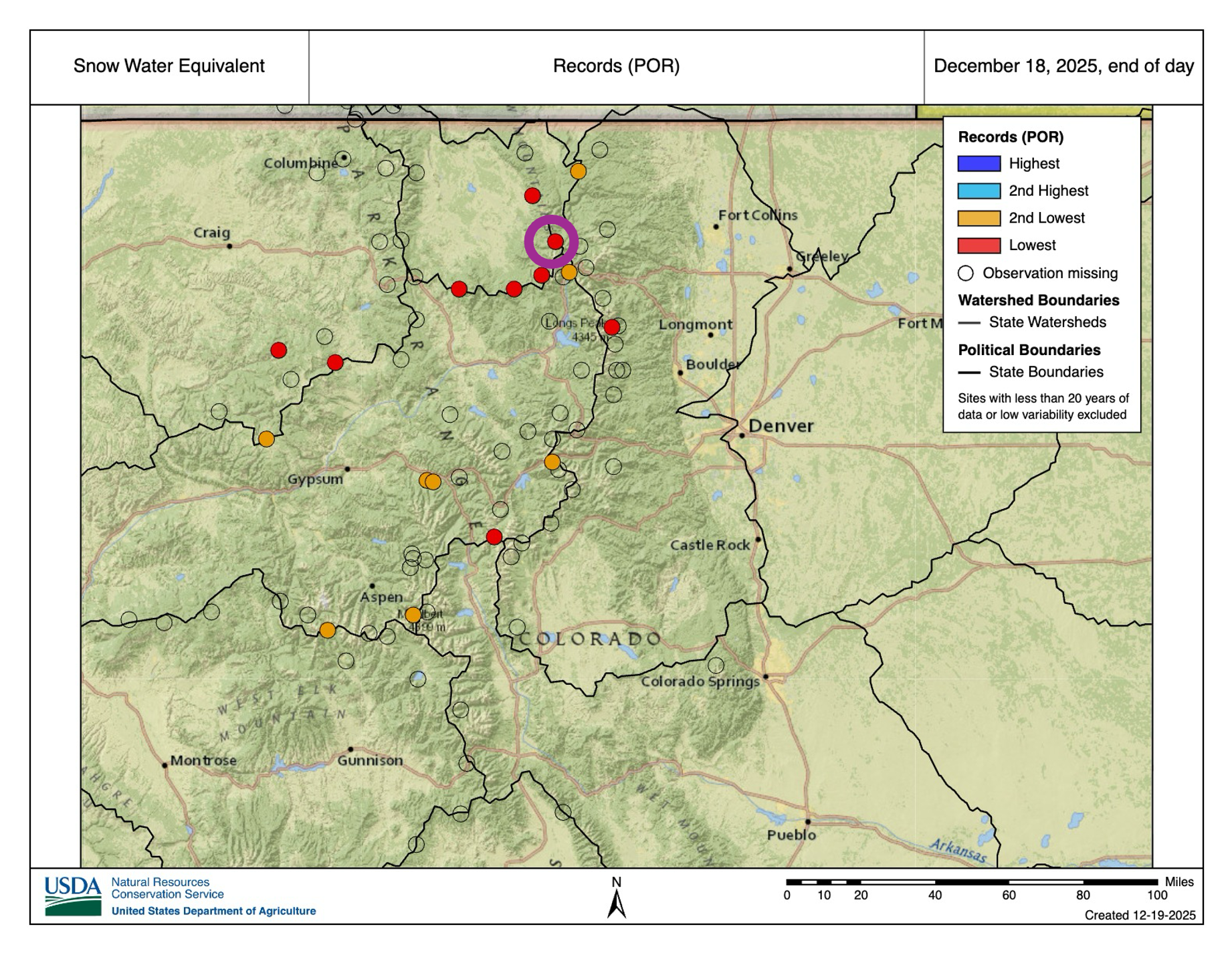
While basin-wide percentages are similar across the state, there are some particularly concerning numbers across the state’s northern basins. There, several SNOTEL stations are currently reporting their lowest or second-lowest snowpack on record. While it’s worth noting that several of these sites have relatively short record periods (~22 years) compared to others in the SNOTEL database, there are some stations with 40+ year records that are reporting record or near-record low values for this time in the winter. Even though a major portion of the snow accumulation is still ahead of us, with more dry weather in the forecast (more on that below), that is all bad news from a water perspective.

Across the lower elevations, snow is also in short supply. Boulder and Denver each saw their latest and 2nd-latest first snows on record at the tail-end of November. And so far, the Front Range Urban Corridor has only seen one shovel-able snowstorm this winter (that happened on Dec. 3). Aside from those two events, Front Range flakes have been few and far between, as warm temperatures have often favored rain over snow (though liquid precipitation has also been in short supply). And further east on the Plains, many have yet to see their first flakes.
Record-setting temperatures
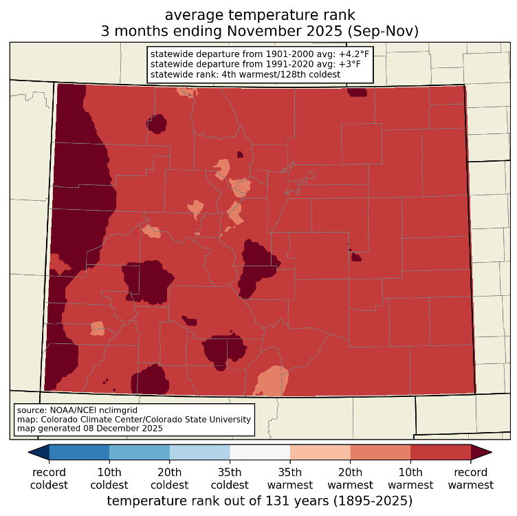
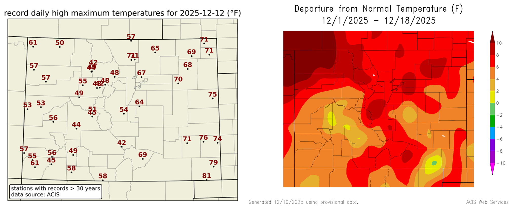
Above-normal temperatures have been a familiar story throughout autumn and early winter. Fall 2025 (September-November) was the 4th warmest on record, and much of that abnormal heat can be attributed to November (ranked the 3rd-warmest on record for Colorado according to NOAA NCEI). No areas of the state were spared from the unusually warm temperatures, but the heat was most notable along the West Slope, where some locations saw their warmest fall on record.
Mid-December has offered little relief from the record-setting heat, with widespread daily records in all corners of the state several days in mid-December. Here in Fort Collins, we notched our warmest 7-day December period on record over December 9-15. Denver recorded 9 straight days of temperatures exceeding 60°F, the 2nd-longest December streak of 60°F+ days on record (h/t to Chris Bianchi). December temperatures so far are running above average nearly everywhere in Colorado, exceeding 8-10°F (or more) above average in some parts of the state.
Drought
The worst drought in the state continue to be in western Colorado, though conditions have begun to worsen in other parts of the state. A notable precipitation event just before Thanksgiving prevented drought from worsening in western and southwestern Colorado, and some locations even saw some minor drought improvements according to the U.S. Drought Monitor. The story is quite different if you look at north-central Colorado, however. A very dry November led to worsening drought conditions for areas that were previously drought-free. Degradations have also occurred across south-central Colorado. As of December 16, ~36% of the state is experiencing drought. That is up from ~29% at the start of November.
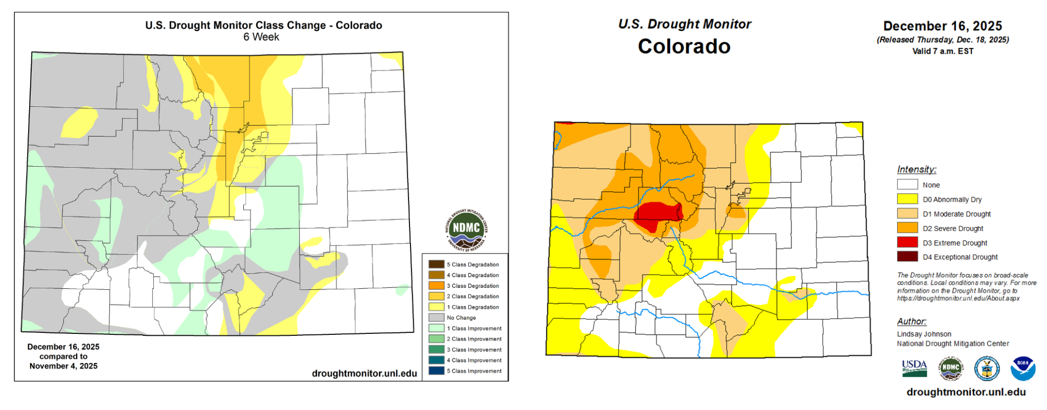
Warm and dry conditions have been accompanied by high wildfire risk. Strong winds coupled with the lack of precipitation and snow-free ground cover in the Foothills has brought favorable fire weather conditions throughout this past week. On December 17, downslope winds produced severe wind gusts in excess of 100 mph. A cold front later in the day pushed gusty winds across the Eastern Plains, fanning several fires near Yuma that were ignited by downed power lines. Exceptionally dry and windy conditions returned on December 19, prompting the NWS in Boulder issued its first-ever Particularly Dangerous Situation (PDS) Red Flag Warning on December 19, a descriptor reserved only for the most severe fire risk days. The NOAA Storm Prediction Center also included parts of the Front Range Foothills and Urban Corridor in an “extremely critical” risk area in their Fire Weather Outlook, which is uncommon to see anywhere in Colorado (no more than a few of those forecasts are issued statewide each year), but they are exceptionally rare during the wintertime. Forecast products aside, fire season is year-round for Colorado’s lower elevations, as was underscored by the devastation brought by the Marshall Fire in December 2021.

Outlook
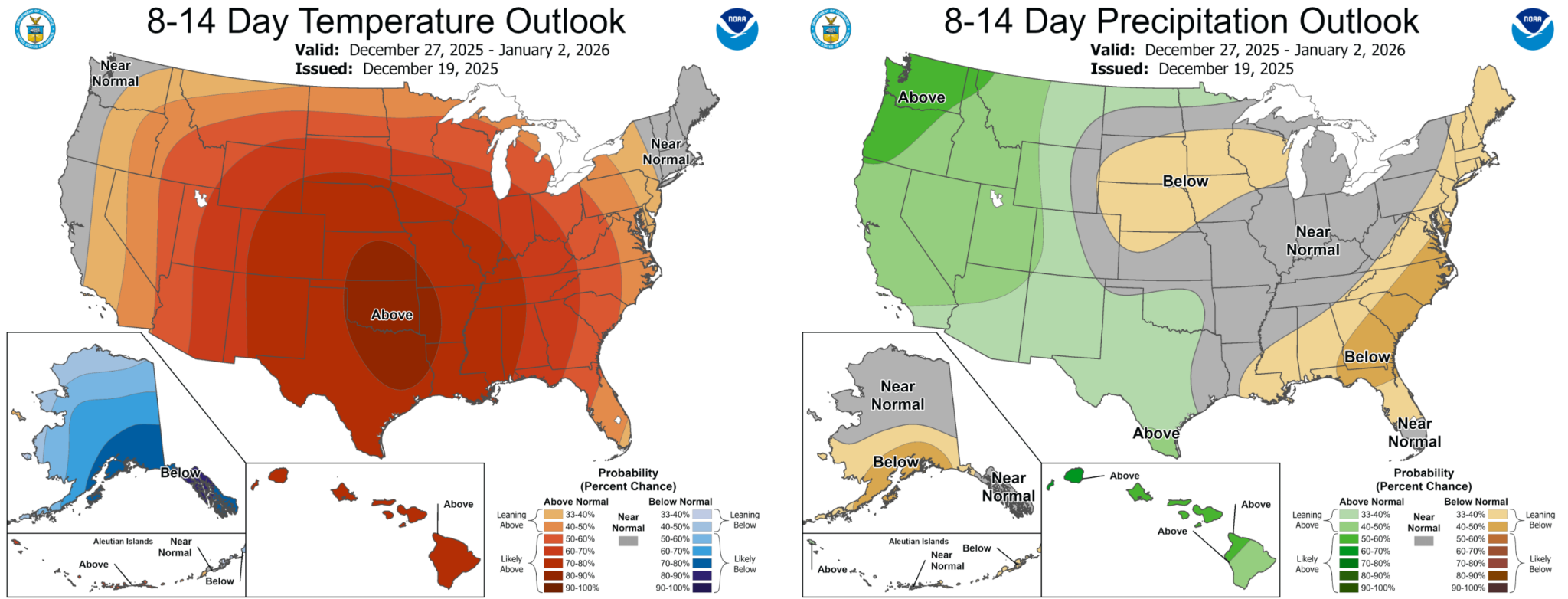
Looking ahead at the rest of December, there is high confidence that above-normal temperatures will persist across Colorado. The 8-14 Day NOAA Climate Prediction Center Outlook shows a 70-80% chance that temperatures will be above average during the final week of 2025. For precipitation, it is likely that a series of atmospheric rivers will make landfall along the West Coast throughout the last couple of weeks of December. While impacts will be greatest for the coastal states, global numerical weather prediction models indicate that these events will bring increased moisture to Colorado, especially the western part of the state. As a result, the CPC shows elevated chances for above-normal precipitation over Western Colorado during the December 26-January 1 period, which is welcome news from a drought and snowpack perspective. Current forecast model data shows that precipitation chances over the next two weeks diminish as you head further east across Colorado, and the CPC suggests that below-normal precipitation is favored for the 8-14 day period over the far eastern part of the state.
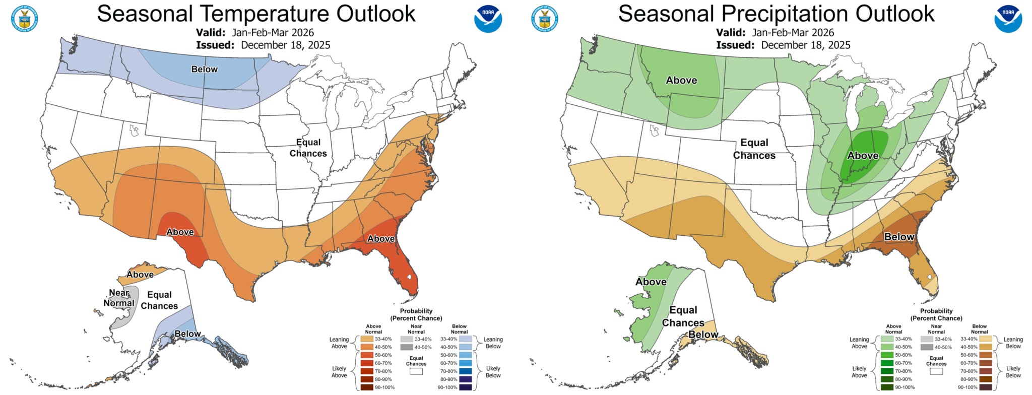
Looking further ahead towards the seasonal outlook for January-March, precipitation and temperature outlooks are less certain. The CPC outlook for the first three months of 2026 shows increased likelihood for above-average temperatures in Southwest Colorado and equal chances for above- or below-normal temperatures elsewhere. In terms of precipitation, the January outlook has Colorado sitting between increased chances of wetter than normal conditions over the Northwest U.S. and increased chances of drier than normal conditions over the Southwest U.S, highlighting uncertainty in what the rest of winter will bring. This pattern in the outlook is reflective of a typical wintertime La Niña setup, which usually situates Colorado between dry conditions to the south and wet conditions to the north (though results found in our Climate Change in Colorado Report suggest La Niña correlates with wetter conditions over the Northern Mountains, making the recent snowpack numbers even more concerning). La Niña conditions are expected to persist into early 2026 and are forecasted to shift towards the ENSO neutral phase sometime in late winter or early spring.